|
River Coe
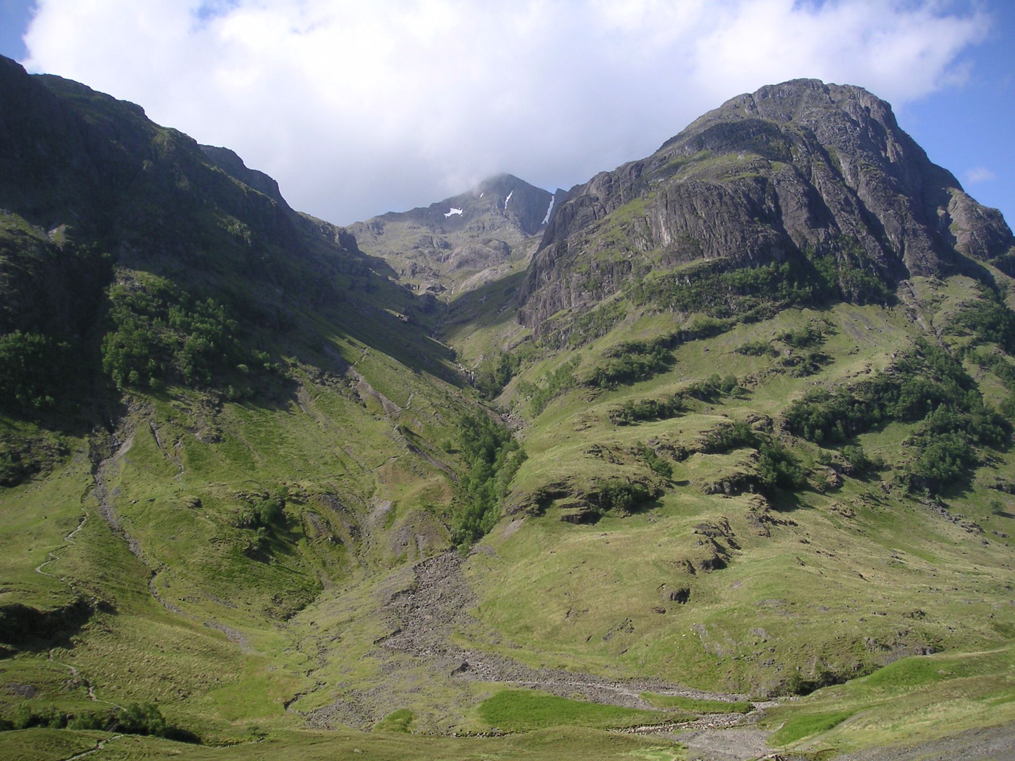
The River Coe ( gd, Comhan) rises at the north-eastern base of Buachaille Etive Beag in Scotland and flows west along Glen Coe. After dramatic waterfalls at the Pass of Glen Coe, it runs through the small Loch Achtriochtan before it turns north west. It then runs past the site of the Massacre of Glencoe and passes through Glencoe village, shortly before flowing into the sea loch of Loch Leven (a salt-water arm of Loch Linnhe Loch Linnhe () is a sea loch on the west coast of Scotland. The part upstream of Corran is known in Gaelic as (the black pool, originally known as Loch Abar), and downstream as (the salty pool). The name ''Linnhe'' is derived from the Gaelic ...) at Invercoe. Lochaber Coe Glen Coe {{Scotland-river-stub ... [...More Info...] [...Related Items...] OR: [Wikipedia] [Google] [Baidu] |
Buachaille Etive Beag
Buachaille Etive Beag (, gd, Buachaille Èite Beag, 'little herdsman of Etive') is a mountain between Glen Coe and Glen Etive in the Highlands of Scotland. It lies west of Buachaille Etive Mòr, its larger neighbour, from which it is separated by a high mountain pass called Lairig Gartain. Like its neighbour, Buachaille Etive Beag is a ridge about 3 km long that runs in a southwest–northeast direction. It has two peaks of Munro status: Stob Dubh (958 m) at the southern end, and Stob Coire Raineach (925 m) in the middle. The latter became a Munro in the 1997 revision of Munro's Tables, in which all tops with a topographic prominence of more than 500 feet (152.4 m) were promoted to full Munro status. The smaller peak at the northern end is Stob nan Cabar. Climbing The most common route on the mountain starts from the A82 at the head of Glen Coe. A cairn and a sign mark the existence of a right-of-way to Glen Etive, following the through the Lairig Eilde tha ... [...More Info...] [...Related Items...] OR: [Wikipedia] [Google] [Baidu] |
Glen Coe
Glen Coe ( gd, Gleann Comhann ) is a glen of volcanic origins, in the Highlands of Scotland. It lies in the north of the county of Argyll, close to the border with the historic province of Lochaber, within the modern council area of Highland. Glen Coe is regarded as the home of Scottish mountaineering and is popular with hillwalkers and climbers. A 2010 review by Scottish Natural Heritage into the special qualities of Scotland's National scenic areas listed the "soaring, dramatic splendour of Glen Coe", and "the suddenness of the transition between high mountain pass and the lightly wooded strath" as being of note. The review also described the journey through the glen on the main A82 road as "one of the classic Highland journeys". The main settlement is the village of Glencoe located at the foot of the glen.Ordnance Survey Landranger 1:50000, Sheet 41 On the 13 February 1692, in the aftermath of the Jacobite uprising of 1689, an incident known as the Massacre of Glencoe ... [...More Info...] [...Related Items...] OR: [Wikipedia] [Google] [Baidu] |
Massacre Of Glencoe
The Massacre of Glencoe ( gd, Murt Ghlinne Comhann) took place in Glen Coe in the Highlands of Scotland on 13 February 1692. An estimated 30 members and associates of Clan MacDonald of Glencoe were killed by Scottish government forces, allegedly for failing to pledge allegiance to the new monarchs, William III and Mary II. Although the Jacobite rising of 1689 was no longer a serious threat by May 1690, unrest continued in the remote Highlands which consumed military resources the government needed for the Nine Years' War in Flanders. In late 1690, the Scottish government agreed to pay the Jacobite clan chiefs a total of £12,000 in return for swearing an oath of loyalty to William and Mary; however, disagreements over how to divide the money meant by December 1691 none of them had taken the oath. Under pressure from William, Secretary of State Lord Stair decided to make an example as a warning of the consequences for further delay. The Glencoe MacDonalds were not the on ... [...More Info...] [...Related Items...] OR: [Wikipedia] [Google] [Baidu] |
Glencoe, Highland
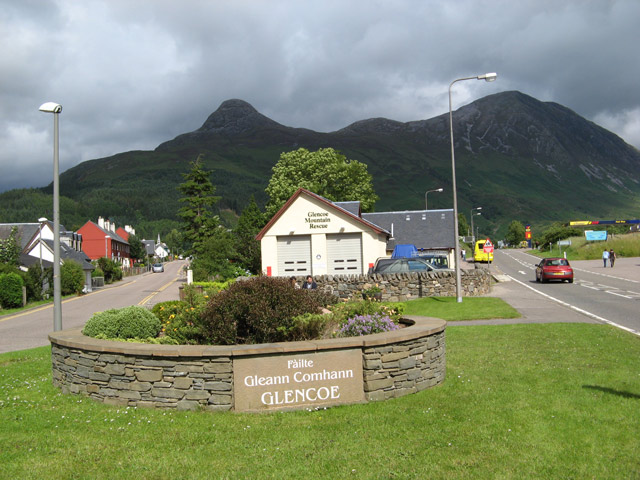
Glencoe or Glencoe Village ( Gaelic: ''A’ Chàrnaich'') is the main settlement in Glen Coe in the Lochaber area of the Scottish Highlands. It lies at the north-west end of the glen, on the southern bank of the River Coe where it enters Loch Leven (a salt-water loch off Loch Linnhe). The village falls within the Ross, Skye and Lochaber part of the Highland council area for local government purposes. It is part of the registration county of Argyll and the lieutenancy area of Inverness for ceremonial functions. The use of the term 'Glencoe Village' is a modern one, to differentiate the settlement from the glen itself. History The village is on the site of the Massacre of Glencoe in 1692, in which 38 members of the Clan MacDonald of Glencoe were killed by forces acting on behalf of the government of King William III following the Glorious Revolution. Treachery was involved, since the Clan had fed the soldiers and given them shelter for nearly two weeks before they turned on ... [...More Info...] [...Related Items...] OR: [Wikipedia] [Google] [Baidu] |
Loch Leven (Highlands)
Loch Leven (Scottish Gaelic: ''Loch Liobhann'') is a sea loch located on the west coast of Scotland. It is spelled ''Loch Lyon'' in Timothy Pont's map of the area and is pronounced Li' un. The local Gaelic pronunciation is Lee' oon Loch Leven extends , varying in width between and just over . It opens onto Camus a' Chois at North Ballachulish, part of Loch Linnhe at its western end. There are nine small islands, some rocky and covered with heather and some just smooth green grass, near the western end of the loch. The village of Glencoe ( gd, A' Chàrnaich) lies on its southern shore. The burial place of the MacDonald clan of Glencoe lies on an island - Eilean Munde, St.Munda's or St Munn's or Saint Fintan Munnu's Island, opposite the village. The island burial place was also shared by the Camerons of Callart, on the north shore of the loch, the Stewarts of Ballachulish and Appin and other local families. The village of Kinlochleven at the head of the loch was established ... [...More Info...] [...Related Items...] OR: [Wikipedia] [Google] [Baidu] |
Loch Linnhe
Loch Linnhe () is a sea loch on the west coast of Scotland. The part upstream of Corran is known in Gaelic as (the black pool, originally known as Loch Abar), and downstream as (the salty pool). The name ''Linnhe'' is derived from the Gaelic word , meaning "pool". Loch Linnhe follows the line of the Great Glen Fault, and is the only sea loch along the fault. About long, it opens onto the Firth of Lorne at its southwestern end. The part of the loch upstream of Corran is long and an average of about wide. The southern part of the loch is wider, and its branch southeast of the island of Lismore is known as the Lynn of Lorne. Loch Eil feeds into Loch Linnhe at the latter's northernmost point, while from the east Loch Leven feeds in the loch just downstream of Corran and Loch Creran feeds into the Lynn of Lorne. The town of Fort William lies at the northeast end of the loch, at the mouth of the River Lochy. According to the Bard Fr. Allan MacDonald, an important figure ... [...More Info...] [...Related Items...] OR: [Wikipedia] [Google] [Baidu] |
Lochaber
Lochaber ( ; gd, Loch Abar) is a name applied to a part of the Scottish Highlands. Historically, it was a provincial lordship consisting of the parishes of Kilmallie and Kilmonivaig, as they were before being reduced in extent by the creation of '' Quoad Sacra'' parishes in the 19th century. Lochaber once extended from the Northern shore of Loch Leven, a district called Nether Lochaber, to beyond Spean Bridge and Roybridge, which area is known as Brae Lochaber or ''Braigh Loch Abar'' in Gaelic. Lochaber is now also used to refer to a much wider area, one of the 16 ward management areas of the Highland Council of Scotland and one of eight former local government districts of the two-tier Highland region. The main town of Lochaber is Fort William. According to legend, a glaistig, a ghostly woman-goat hybrid, once lived in the area. Name William Watson outlined two schools of thought on this topic. He favoured the idea that ''Abar'' came from the Pictish and Welsh for "r ... [...More Info...] [...Related Items...] OR: [Wikipedia] [Google] [Baidu] |
Rivers Of Highland (council Area)
A river is a natural flowing watercourse, usually freshwater, flowing towards an ocean, sea, lake or another river. In some cases, a river flows into the ground and becomes dry at the end of its course without reaching another body of water. Small rivers can be referred to using names such as creek, brook, rivulet, and rill. There are no official definitions for the generic term river as applied to geographic features, although in some countries or communities a stream is defined by its size. Many names for small rivers are specific to geographic location; examples are "run" in some parts of the United States, "burn" in Scotland and northeast England, and "beck" in northern England. Sometimes a river is defined as being larger than a creek, but not always: the language is vague. Rivers are part of the water cycle. Water generally collects in a river from precipitation through a drainage basin from surface runoff and other sources such as groundwater recharge, springs, ... [...More Info...] [...Related Items...] OR: [Wikipedia] [Google] [Baidu] |


