|
Rheindahlen
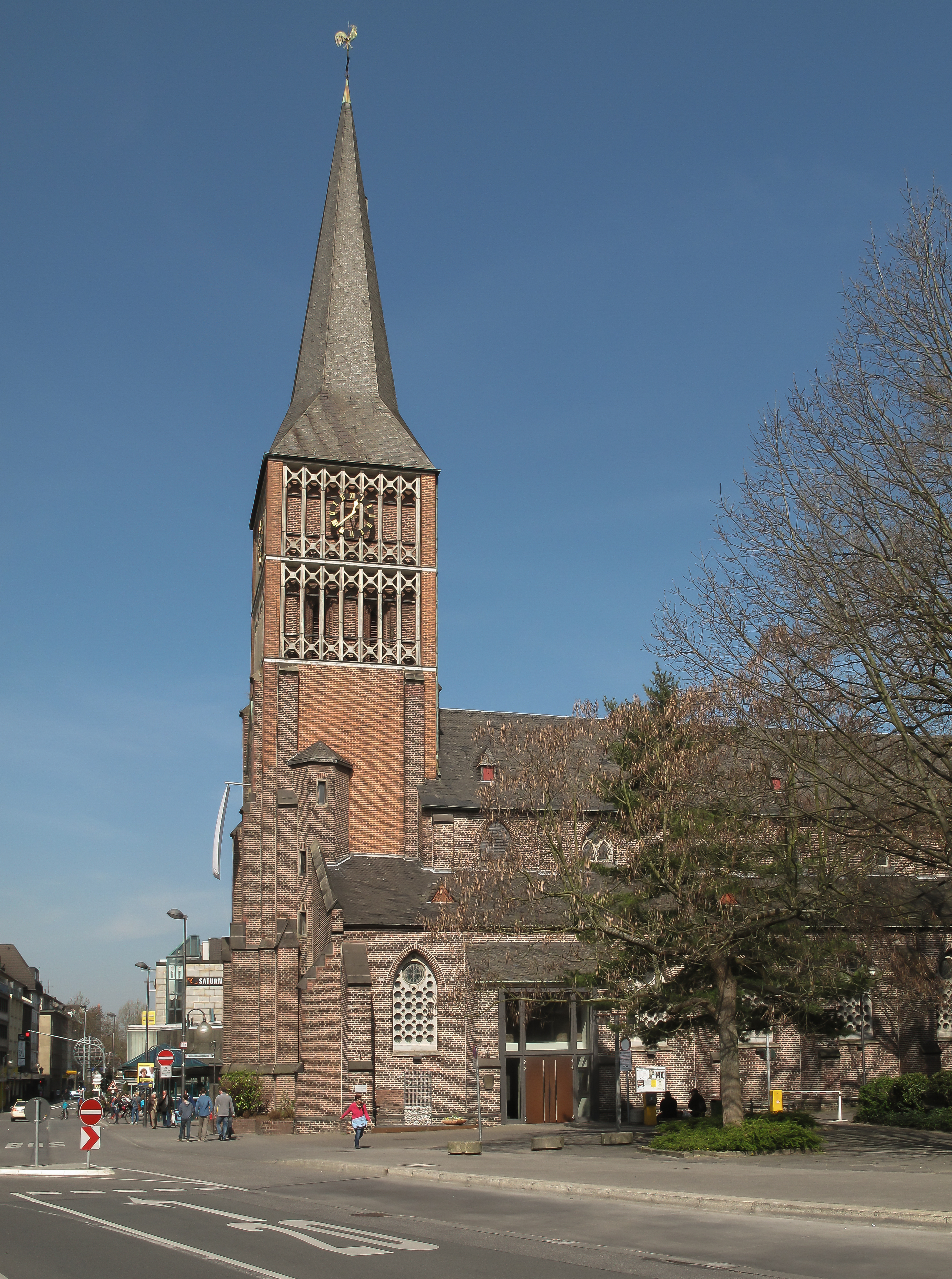
Rheindahlen (called ''Dalen'' from the Early Middle Ages to the Early Modern Period around 1700, and ''Dahlen'' until 1878) is a town in the western and largest borough of the city of Mönchengladbach in the German state of North Rhine-Westphalia. Since the reorganisation of Monchengladbach's boroughs (''Stadtbezirke'') on 22 October 2009 Rheindahlen has been part of Mönchengladbach West. From the granting of Nideggen town rights in 1354 until the incorporation of the mayoralty of Rheindahlen into M.-Gladbach on 30 June 1921, the place was an independent town. In 1878, the town was renamed from ''Dahlen'' to ''Rheindahlen'' in the Prussian Province of Düsseldorf by order of Emperor William I. Its renaming was primarily for postal reasons in order to avoid confusing the Dahlen in the Rhine Province with the municipality of Dahlen in Saxony within the North German Postal Zone. Its old name linguistically meant ''Delle'' or "hollow", which refers to the location of the village ... [...More Info...] [...Related Items...] OR: [Wikipedia] [Google] [Baidu] |
JHQ Rheindahlen
JHQ (Joint Headquarters) Rheindahlen was a military base in Mönchengladbach, North Rhine-Westphalia, Germany active from 1954 to 2013. It functioned as the main headquarters for British forces in Germany and for the NATO Northern Army Group. Latterly it was also known as the Rheindahlen Military Complex, part of Rheindahlen Garrison. It was named after the local village of Rheindahlen, part of the city borough of Mönchengladbach. History In 1952, work began on the British Forces Maintenance Area West of the Rhine. Part of the project included the construction of a joint British Army and Royal Air Force headquarters for the British Army of the Rhine (BAOR) in Rheindahlen. Colonel Henry Grattan was Chief Engineer of the construction project. HQ BAOR moved from Bad Oeynhausen to Rheindahlen in October 1954, centralising headquarters functions previously located across several towns in Northern Germany. It was originally the HQ of the Northern Army Group (NORTHAG), Second Allied Ta ... [...More Info...] [...Related Items...] OR: [Wikipedia] [Google] [Baidu] |
Mönchengladbach West
Mönchengladbach (, li, Jlabbach ) is a city in North Rhine-Westphalia, Germany. It is located west of the Rhine, halfway between Düsseldorf and the Dutch border. Geography Municipal subdivisions Since 2009, the territory of Mönchengladbach has comprised four (previously ten) boroughs which are subdivided into 44 districts. The boroughs and their associated districts * ''Nord:'' Am Wasserturm, Dahl, Eicken, Gladbach, Hardt-Mitte, Hardter Wald, Ohler, Venn, Waldhausen, Westend, Windberg * ''Ost:'' Bettrath‑Hoven, Bungt, Flughafen, Giesenkirchen‑Mitte, Giesenkirchen‑Nord, Hardterbroich‑Pesch, Lürrip, Neuwerk‑Mitte, Schelsen, Uedding * ''Süd:'' Bonnenbroich‑Geneicken, Geistenbeck, Grenzland‑Stadion, Heyden, Hockstein, Mülfort, Odenkirchen‑Mitte, Odenkirchen‑West, Pongs, Rheydt, Sasserath, Schloss Rheydt, Schmölderpark, Schrievers * ''West:'' Hauptquartier, Hehn, Holt, Rheindahlen‑Land, Rheindahlen‑Mi ... [...More Info...] [...Related Items...] OR: [Wikipedia] [Google] [Baidu] |
Mönchengladbach
Mönchengladbach (, li, Jlabbach ) is a city in North Rhine-Westphalia, Germany. It is located west of the Rhine, halfway between Düsseldorf and the Dutch border. Geography Municipal subdivisions Since 2009, the territory of Mönchengladbach has comprised four (previously ten) boroughs which are subdivided into 44 districts. The boroughs and their associated districts * ''Nord:'' Am Wasserturm, Dahl, Eicken, Gladbach, Hardt-Mitte, Hardter Wald, Ohler, Venn, Waldhausen, Westend, Windberg * ''Ost:'' Bettrath‑Hoven, Bungt, Flughafen, Giesenkirchen‑Mitte, Giesenkirchen‑Nord, Hardterbroich‑Pesch, Lürrip, Neuwerk‑Mitte, Schelsen, Uedding * ''Süd:'' Bonnenbroich‑Geneicken, Geistenbeck, Grenzland‑Stadion, Heyden, Hockstein, Mülfort, Odenkirchen‑Mitte, Odenkirchen‑West, Pongs, Rheydt, Sasserath, Schloss Rheydt, Schmölderpark, Schrievers * ''West:'' Hauptquartier, Hehn, Holt, Rheindahlen‑Land, Rheindahlen‑Mi ... [...More Info...] [...Related Items...] OR: [Wikipedia] [Google] [Baidu] |
Lower Rhine Bay
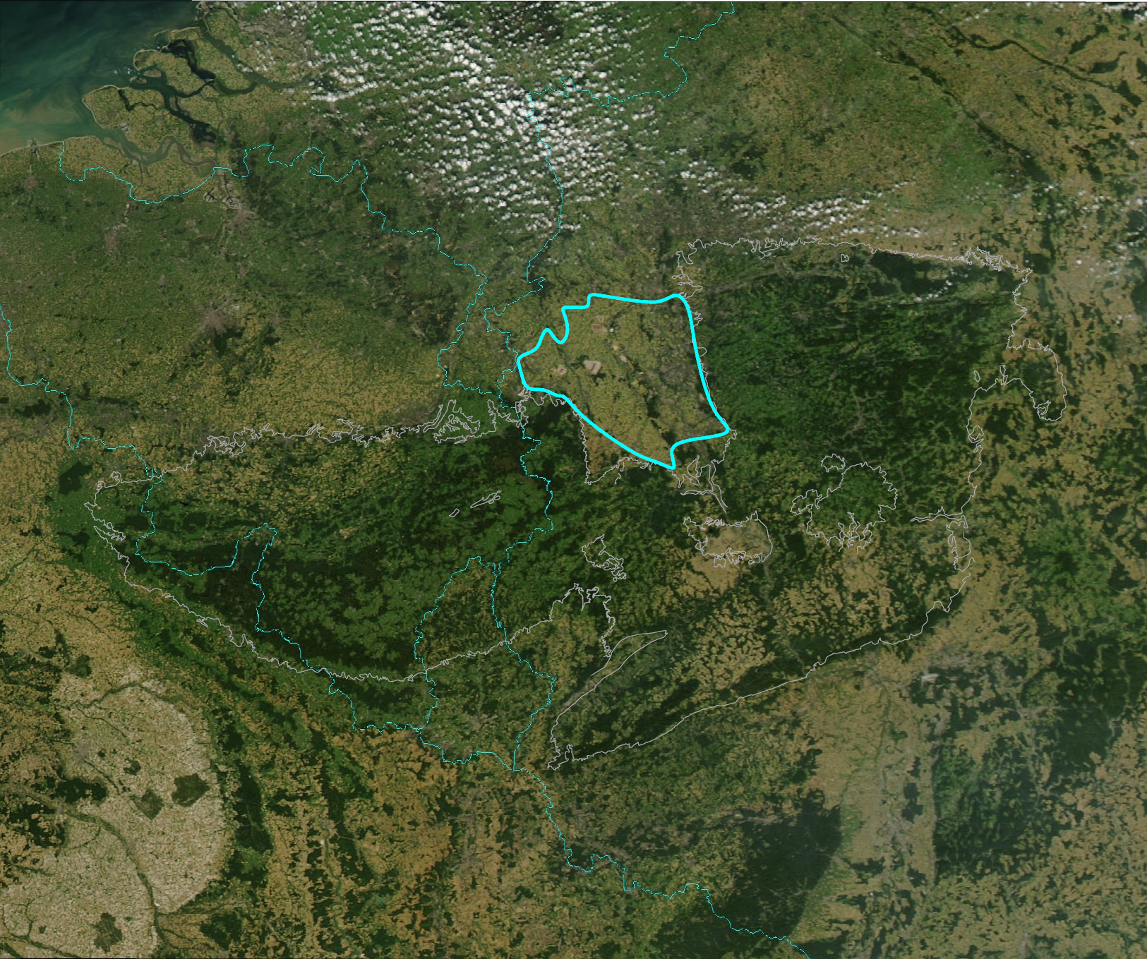
The Lower Rhine Bay (german: Niederrheinische Bucht), sometimes called the Lower Rhine Bight,Luttig, G.W. (ed.), ''General Geology of the Federal Republic of Germany'', Nagel u. Obermiller, 1980, pp. 29 and 44. is a lowland plain in the German state of North Rhine-Westphalia that cuts into the Rhenish Massif. From a natural region perspective it is a major unit group which includes the Cologne Lowland around the city of Cologne as well as the land lying to the west and, in a clearly narrower strip of land, to the east of the central Cologne plain. That said, the term "Cologne Bay" or "Cologne Bight" is occasionally used, ''pars pro toto'', for the entire region. The Lower Rhine Bay covers an area of 3,584.4 km².Meynen, E. and Schmithüsen, J., ''Handbuch der naturräumlichen Gliederung Deutschlands.'' Bundesanstalt für Landeskunde, Remagen/Bad Godesberg, 1953–1962 (9 issues in 8 books, updated map at 1:1,000,000 scale with major units, 1960). Location and boundaries T ... [...More Info...] [...Related Items...] OR: [Wikipedia] [Google] [Baidu] |
Gulf Stream
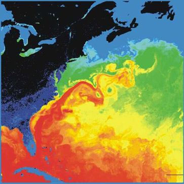
The Gulf Stream, together with its northern extension the North Atlantic Current, North Atlantic Drift, is a warm and swift Atlantic Ocean, Atlantic ocean current that originates in the Gulf of Mexico and flows through the Straits of Florida and up the eastern coastline of the United States then veers east near 36 latitude (North Carolina) and moves toward Northwest Europe as the North Atlantic Current. The process of Boundary current, western intensification causes the Gulf Stream to be a northwards accelerating current off the east coast of North America. At about , it splits in two, with the northern stream, the North Atlantic Drift, crossing to Northern Europe and the southern stream, the Canary Current, recirculating off West Africa. The Gulf Stream influences the climate of the coastal areas of the east coast of the United States from Florida to southeast Virginia (near 36 north latitude), and to a greater degree the climate of Northwest Europe. There is consensus that t ... [...More Info...] [...Related Items...] OR: [Wikipedia] [Google] [Baidu] |
Climate
Climate is the long-term weather pattern in an area, typically averaged over 30 years. More rigorously, it is the mean and variability of meteorological variables over a time spanning from months to millions of years. Some of the meteorological variables that are commonly measured are temperature, humidity, atmospheric pressure, wind, and precipitation. In a broader sense, climate is the state of the components of the climate system, including the atmosphere, hydrosphere, cryosphere, lithosphere and biosphere and the interactions between them. The climate of a location is affected by its latitude/longitude, terrain, altitude, land use and nearby water bodies and their currents. Climates can be classified according to the average and typical variables, most commonly temperature and precipitation. The most widely used classification scheme was the Köppen climate classification. The Thornthwaite system, in use since 1948, incorporates evapotranspiration along with temperature ... [...More Info...] [...Related Items...] OR: [Wikipedia] [Google] [Baidu] |
Fault Block
Fault blocks are very large blocks of rock, sometimes hundreds of kilometres in extent, created by tectonic and localized stresses in Earth's crust. Large areas of bedrock are broken up into blocks by faults. Blocks are characterized by relatively uniform lithology. The largest of these fault blocks are called crustal blocks. Large crustal blocks broken off from tectonic plates are called terranes. Those terranes which are the full thickness of the lithosphere are called microplates. Continent-sized blocks are called variously ''microcontinents, continental ribbons, H-blocks, extensional allochthons and outer highs.'' Because most stresses relate to the tectonic activity of moving plates, most motion between blocks is horizontal, that is parallel to the Earth's crust by strike-slip faults. However vertical movement of blocks produces much more dramatic results. Landforms (mountains, hills, ridges, lakes, valleys, etc.) are sometimes formed when the faults have a large v ... [...More Info...] [...Related Items...] OR: [Wikipedia] [Google] [Baidu] |
Rheydt
Rheydt () is a borough of the Germany, German city Mönchengladbach, located in the west of North Rhine-Westphalia. Until 1918 and then again from 1933 (due to a split from Mönchengladbach arranged by Joseph Goebbels, who was born there) through 1975 it was an independent city. After merging with Mönchengladbach, the central station (Rheydt Hauptbahnhof) kept its original name, making Mönchengladbach the only city in Germany to have two stations called Hauptbahnhof. Schloss Rheydt, one of the best-preserved palaces of the Renaissance period, is located in Rheydt. Mayors 1808–1974 *1808–1823: Dietrich Lenßen *1823–1857: Johann David Büschgens *1857–1877: Carl Theodorf von Velsen *1877–1893: Emil Pahlke *1893–1901: Dr. Wilhelm Strauß *1901–1905: Dr. Karl August Tettenborn *1906–1920: Paul Lehwald *1920–1929: Dr. Oskar Graemer *1929–1930: Franz Gielen *1930–1933: Dr. Johannes Handschumacher *1933: Wilhelm Pelzer *1934–1936: Edwin Renatus Robert August ... [...More Info...] [...Related Items...] OR: [Wikipedia] [Google] [Baidu] |
Groundwater
Groundwater is the water present beneath Earth's surface in rock and soil pore spaces and in the fractures of rock formations. About 30 percent of all readily available freshwater in the world is groundwater. A unit of rock or an unconsolidated deposit is called an aquifer when it can yield a usable quantity of water. The depth at which soil pore spaces or fractures and voids in rock become completely saturated with water is called the water table. Groundwater is recharged from the surface; it may discharge from the surface naturally at springs and seeps, and can form oases or wetlands. Groundwater is also often withdrawn for agricultural, municipal, and industrial use by constructing and operating extraction wells. The study of the distribution and movement of groundwater is hydrogeology, also called groundwater hydrology. Typically, groundwater is thought of as water flowing through shallow aquifers, but, in the technical sense, it can also contain soil moisture, perma ... [...More Info...] [...Related Items...] OR: [Wikipedia] [Google] [Baidu] |
Thickness (geology)
Thickness in geology and mining refers to the distance across a packet of rock, whether it be a facies, stratum, bed, seam, lode etc. Thickness is measured at right angles to the surface of the seam or bed and thus independently of its spatial orientation. The concept of thickness came originally from mining language, where it was used mainly to indicate the workability of seams. It has since become an established term in earth science, for example in geology, for the depth of sedimentary rocks, in hydrogeology for the vertical extent of groundwater – i.e. the distance from the base of the groundwater layer to its surface – or in soil science for the vertical extent of soil horizon A soil horizon is a layer parallel to the soil surface whose physical, chemical and biological characteristics differ from the layers above and beneath. Horizons are defined in many cases by obvious physical features, mainly colour and texture. ...s. Literature * Walter Bischoff, Heinz Brama ... [...More Info...] [...Related Items...] OR: [Wikipedia] [Google] [Baidu] |
Garzweiler Mine
The Tagebau Garzweiler is a surface mine (german: Tagebau) in the German state of North Rhine-Westphalia. It is operated by RWE and used for mining lignite. The mine currently has a size of 48 km² and got its name from the village of which previously existed at this location. The community was moved to a section of Jüchen with the same name. The open-pit mine The mine is located west of Grevenbroich and exploitation is progressing towards Erkelenz. Mining was originally limited to the 66.0 km² area ''Garzweiler I'' located east of motorway A 44. Mining in the 48.0 km² ''Garzweiler II'' sector started in 2006 and it will take until around 2045 to fully exploit both sectors. The lignite is used for power generation at nearby power plants such as Neurath and Niederaußem. It is not yet known what effect the plan to phase out all coal-fired power plants in Germany by 2038 will have on the Garzweiler lignite mine system. Traffic Motorways A 44 and A 61 ... [...More Info...] [...Related Items...] OR: [Wikipedia] [Google] [Baidu] |
Open-cast Pit
Open-pit mining, also known as open-cast or open-cut mining and in larger contexts mega-mining, is a surface mining technique of extracting rock or minerals from the earth from an open-air pit, sometimes known as a borrow. This form of mining differs from extractive methods that require tunnelling into the earth, such as long wall mining. Open-pit mines are used when deposits of commercially useful ore or rocks are found near the surface. It is applied to ore or rocks found at the surface because the overburden is relatively thin or the material of interest is structurally unsuitable for tunnelling (as would be the case for cinder, sand, and gravel). In contrast, minerals that have been found underground but are difficult to retrieve due to hard rock, can be reached using a form of underground mining. To create an open-pit mine, the miners must determine the information of the ore that is underground. This is done through drilling of probe holes in the ground, then plotting eac ... [...More Info...] [...Related Items...] OR: [Wikipedia] [Google] [Baidu] |


