|
Reddevitz HÃķft
The Reddevitz HÃķft or Reddevitzer HÃķft is a peninsular forming part of the Germany, German Baltic Sea island of RÞgen. It is part of the MÃķnchgut peninsula, with which it is linked in the southeast by a good 130 metre wide isthmus. The Reddevitzer HÃķft is over four kilometres long and up to 500 metres wide. In its western part, which end in a cliffed coast, the land climbs to a height of over 33 metres. At the eastern end is the village of Alt Reddevitz, part of the municipality of Middelhagen. The namen is derived from the Low German word ''hÃķft'' for "head". In the north the Reddevitzer HÃķft borders on the Having (inlet), Having and in the south on the Hagensche Wiek, to the west and southwest lies the Bay of Greifswald. The peninsula, which lies within the Southeast RÞgen Biosphere Reserve, is the largest contiguous stretch of heathland on the island of RÞgen and is classed as a natural monument. Reddevitzer-HÃķft-0810f-230.JPG, The Reddevitzer HÃķft Reddevitzer-Hà ... [...More Info...] [...Related Items...] OR: [Wikipedia] [Google] [Baidu] |
Having (inlet)
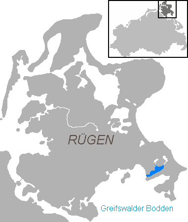
The Having is an inlet in the northeast of the RÞgischer Bodden, the northern half of the Bay of Greifswald, which cuts deeply into the peninsula of MÃķnchgut, the southeastern tip of the German island of RÞgen. The inlet is about 5.7 kilometres long, 1.1 kilometres wide and has an area of 7.5 kmÂē. It opens towards the southwest onto the RÞgische Bodden. The Having is up to eight metres deep. In the south the Having is bounded by the narrow, elongated peninsula of Reddevitzer HÃķft, in the north by the Granitz. In the north there are two narrow waterways to the lakes of Selliner See and Neuensiener See. The heights around the bay climb to over 30 metres. There are no settlements on the shores of the Having itself. The inlet is part of the MÃķnchgut Nature Reserve in the Southeast RÞgen Biosphere Reserve The Southeast RÞgen Biosphere Reserve (german: BiosphÃĪrenreservat SÞdost-RÞgen) is a biosphere reserve in the German state of Mecklenburg-Vorpom ... [...More Info...] [...Related Items...] OR: [Wikipedia] [Google] [Baidu] |
Peninsulas Of Mecklenburg-Western Pomerania
A peninsula (; ) is a landform that extends from a mainland and is surrounded by water on most, but not all of its borders. A peninsula is also sometimes defined as a piece of land bordered by water on three of its sides. Peninsulas exist on all continents. The size of a peninsula can range from tiny to very large. The largest peninsula in the world is the Arabian Peninsula. Peninsulas form due to a variety of causes. Etymology Peninsula derives , which is translated as 'peninsula'. itself was derived , or together, 'almost an island'. The word entered English in the 16th century. Definitions A peninsula is usually defined as a piece of land surrounded on most, but not all sides, but is sometimes instead defined as a piece of land bordered by water on three of its sides. A peninsula may be bordered by more than one body of water, and the body of water does not have to be an ocean or a sea. A piece of land on a very tight river bend or one between two rivers is sometimes ... [...More Info...] [...Related Items...] OR: [Wikipedia] [Google] [Baidu] |
Geography Of RÞgen
Geography (from Greek: , ''geographia''. Combination of Greek words âGeoâ (The Earth) and âGraphienâ (to describe), literally "earth description") is a field of science devoted to the study of the lands, features, inhabitants, and phenomena of Earth. The first recorded use of the word ÎģÎĩÏÎģÏÎąÏÎŊÎą was as a title of a book by Greek scholar Eratosthenes (276â194 BC). Geography is an all-encompassing discipline that seeks an understanding of Earth and its human and natural complexitiesânot merely where objects are, but also how they have changed and come to be. While geography is specific to Earth, many concepts can be applied more broadly to other celestial bodies in the field of planetary science. One such concept, the first law of geography, proposed by Waldo Tobler, is "everything is related to everything else, but near things are more related than distant things." Geography has been called "the world discipline" and "the bridge between the human and ... [...More Info...] [...Related Items...] OR: [Wikipedia] [Google] [Baidu] |
Natural Monument
A natural monument is a natural or natural/cultural feature of outstanding or unique value because of its inherent rarity, representative of aesthetic qualities or cultural significance. Under World Commission on Protected Areas guidelines, natural monuments are level III, described as: :"Areas are set aside to protect a specific natural monument, which can be a landform, sea mount, submarine cavern, geological feature such as a cave or even a living feature such as an ancient grove. They are generally quite small protected areas and often have high visitor value." This is a lower level of protection than level II (national parks) and level I (wilderness areas). The European Environment Agency's guidelines for selection of a natural monument are: * The area should contain one or more features of outstanding significance. Appropriate natural features include waterfalls, caves, craters, fossil beds, sand dunes and marine features, along with unique or representative fauna and flo ... [...More Info...] [...Related Items...] OR: [Wikipedia] [Google] [Baidu] |
Southeast RÞgen Biosphere Reserve
The Southeast RÞgen Biosphere Reserve (german: BiosphÃĪrenreservat SÞdost-RÞgen) is a biosphere reserve in the German state of Mecklenburg-Vorpommern, which covers the southeastern part of the island of RÞgen (including Granitz and MÃķnchgut), the lagoon of RÞgischer Bodden between Putbus and Thiessow, the outer coast between Thiessow and Binz and the island of Vilm. In the biosphere reserve all the classic landscape and coastal features of the Mecklenburg-Vorpommern littoral are found within one small area. The land is deeply indented here by the sea. One the one hand, peninsulas and coastal headlands are linked by narrow strips of land, on the other side they are separated by lagoons known as ''boddens'' and open bays called ''Wieken'' locally. There are fine-sanded beaches and rugged cliffed coastlines, at the foot of which are impressive rocky beaches. Broad belts of reed girdle the shores. Beech woods or poor grasslands are found on the sites of terminal moraines and ... [...More Info...] [...Related Items...] OR: [Wikipedia] [Google] [Baidu] |
Bay Of Greifswald
The Bay of Greifswald''Utrata FachwÃķrterbuch: Geographie - Englisch-Deutsch/Deutsch-Englisch'' by JÞrgen Utrata (2014). Retrieved 10 Apr 2014. or Greifswald Bodden (german: Greifswalder Bodden) is a basin in the southwestern , off the shores of in the |
Hagensche Wiek
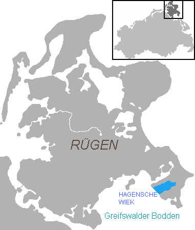
Hagensche Wiek is a cove in the east of the RÞgischer Bodden that cuts deeply into the MÃķnchgut peninsula, the southeast tip of the German island of RÞgen. It is about 5 kilometres long, 2.5 kilometres wide and opens towards the southwest onto the RÞgischer Bodden, the northern half of the Bay of Greifswald. In the north, the Hagensche Wiek is bounded by the narrow, elongated peninsula of Reddevitzer HÃķft, in the south by the actual MÃķnchgut with the Zicker Hills (''Zickersche Berge''), up to 66 metres high. In the east the cove approaches within 1,000 metres of the Baltic Sea coast not far from the village of Lobbe in the municipality of Middelhagen. The municipalities of Gager and Middelhagen with their hamlets of ''Alt Reddevitz'' and ''Mariendorf'' lie on the Hagensche Wiek. In Gager is the only harbour on the bay, used by fishing and sports boats and protected by a mole. The cove is part of the Southeast RÞgen Biosphere Reserve The Southeast RÞ ... [...More Info...] [...Related Items...] OR: [Wikipedia] [Google] [Baidu] |
Low German
: : : : : (70,000) (30,000) (8,000) , familycolor = Indo-European , fam2 = Germanic , fam3 = West Germanic , fam4 = North Sea Germanic , ancestor = Old Saxon , ancestor2 = Middle Low German , dia1 = West Low German , dia2 = East Low German , iso2 = nds , iso3 = nds , iso3comment = (Dutch varieties and Westphalian have separate codes) , lingua = 52-ACB , map = Nds Spraakrebeet na1945.svg , mapcaption = Present day Low German language area in Europe. , glotto = lowg1239 , glottoname = Low German , notice = IPA Low German or Low Saxon (in the language itself: , and other names; german: Plattdeutsch, ) is a West Germanic language variety spoken mainly in Northern Germany and the northeastern part of the Netherlands. The dialect of Plautdietsch is also spoken in the Russian Mennonite diaspora worldwi ... [...More Info...] [...Related Items...] OR: [Wikipedia] [Google] [Baidu] |
Germany
Germany,, officially the Federal Republic of Germany, is a country in Central Europe. It is the second most populous country in Europe after Russia, and the most populous member state of the European Union. Germany is situated between the Baltic and North seas to the north, and the Alps to the south; it covers an area of , with a population of almost 84 million within its 16 constituent states. Germany borders Denmark to the north, Poland and the Czech Republic to the east, Austria and Switzerland to the south, and France, Luxembourg, Belgium, and the Netherlands to the west. The nation's capital and most populous city is Berlin and its financial centre is Frankfurt; the largest urban area is the Ruhr. Various Germanic tribes have inhabited the northern parts of modern Germany since classical antiquity. A region named Germania was documented before AD 100. In 962, the Kingdom of Germany formed the bulk of the Holy Roman Empire. During the 16th ce ... [...More Info...] [...Related Items...] OR: [Wikipedia] [Google] [Baidu] |
Middelhagen
Middelhagen is a village and a former municipality in the Vorpommern-RÞgen district, in Mecklenburg-Vorpommern, Germany. Since January 2018, it is part of the new municipality MÃķnchgut MÃķnchgut (''Monk's Estates'' in German) is a peninsula of 29.44 square kilometers with 6600 inhabitants in the southeast of RÞgen island in Mecklenburg-Western Pomerania, Germany. It lies just between the Greifswalder Bodden and the rest of .... References External links Official website of Middelhagen Towns and villages on RÞgen MÃķnchgut Former municipalities in Mecklenburg-Western Pomerania {{VorpommernRÞgen-geo-stub ... [...More Info...] [...Related Items...] OR: [Wikipedia] [Google] [Baidu] |
Cliffed Coast
A cliffed coast, also called an abrasion coast, is a form of coast where the action of marine waves has formed steep cliffs that may or may not be precipitous. It contrasts with a flat or alluvial coast. Formation In coastal areas in which the land surface dips at a relatively steep angle below the water table, the continuous action of marine waves on the coastline, known as abrasion, may create a steep declivity known as a cliff, the slope angle of which depends on a variety of factors including the jointing, bedding and hardness of the materials making up the cliff as well as the erosional processes themselves.Herbert Louis and Klaus Fischer: ''Allgemeine Geomorphologie'', de Gruyter, 4th ed., Berlin 1979, pp. 532-537 The slope is constantly being eroded. The waves attacking the cliff-foot form a wave-cut notch by constant abrasion action producing an overhang. This overhang grows in size as the cliff is undercut, until it collapses under its own weight. The loose ... [...More Info...] [...Related Items...] OR: [Wikipedia] [Google] [Baidu] |

.jpg)


