|
Rathcoole F
Rathcoole may refer to: * Rathcoole, County Dublin, a village in County Dublin, Ireland * Rathcoole (Newtownabbey), a large housing estate in Newtownabbey, County Antrim, Northern Ireland * Rathcoole, County Cork, a village in north west Cork * Rathcoole, County Kilkenny Rathcoole is a parish in County Kilkenny. It does not give its name to any townland A townland ( ga, baile fearainn; Ulster-Scots: ''toonlann'') is a small geographical division of land, historically and currently used in Ireland and in the ..., a parish in County Kilkenny * Rathcoole Aerodrome, County Cork, Ireland {{geodis ... [...More Info...] [...Related Items...] OR: [Wikipedia] [Google] [Baidu] |
Rathcoole, County Dublin
Rathcoole () is an outer suburban village, south-west of the city of Dublin, in the jurisdiction of South Dublin, Ireland. Rathcoole is also a civil parish in the Barony of Newcastle. Etymology Ráth is the Irish word for a ringfort, a circular embankment often erected by wealthy farmers or local chiefs. There are several forts in the civil parish of Rathcoole, one in a field between the village and Saggart village. There is no definite explanation for the name 'Rathcoole,' but it could well be ''Ráth Cumhaill meaning 'the ringfort of Cumhaill'', the father of Fionn mac Cumhaill. Coole may also come from the Irish word for forest, "coill." Location Rathcoole lies in the southwest "corner" of the traditional County Dublin, just off the N7 national primary road, southwest of Citywest and west of Saggart village. Close by to the north are Baldonnel and Casement Aerodrome, home of the Irish Air Corps. Also in this part of the county are Newcastle and, further away, Brittas ... [...More Info...] [...Related Items...] OR: [Wikipedia] [Google] [Baidu] |
Rathcoole (Newtownabbey)
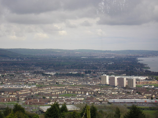
Rathcoole () is a housing estate in Newtownabbey, County Antrim, Northern Ireland. It was built in the 1950s to house many of those displaced by the demolition of inner city housing in Belfast city. Rathcoole is within the wider Antrim and Newtownabbey Borough. Its approximate borders are provided by O'Neill Road on the north, Doagh Road on the east, Shore Road on the south and Church Road and Merville Garden Village on the west. Community history and setting In the 1940s and 1950s, a number of new large-scale housing schemes were planned for Northern Ireland including Craigavon and Rathcoole. These plans were informed by attempts by successive UK governments and the local parliament at Stormont to use large-scale social engineering to reduce underlying sectarian tensions in Northern Ireland. In common with other such areas, Rathcoole's design included self-contained facilities such as a cinema, youth centre, a shopping centre and schools. In spite of these planned faciliti ... [...More Info...] [...Related Items...] OR: [Wikipedia] [Google] [Baidu] |
Rathcoole, County Cork
Rathcoole, also spelled Rathcool () is a village in the north west of County Cork, Ireland. It is in civil parish of Dromtarrife in the barony of Duhallow. Rathcoole is within the Dáil constituency of Cork North-West. Location and amenities Rathcoole is located south of the River Blackwater inbetween Millstreet and Banteer. Rathcoole once had a train station on the Mallow–Tralee line but it closed in 1963. The nearest station is now Banteer railway station. There is a primary school located in the village called St. Brendan's national school. Sport In Gaelic football and hurling, Dromtarriffe GAA club represents Rathcoole, and the club's sports ground is located just outside the village. Rathcoole also has a soccer Association football, more commonly known as football or soccer, is a team sport played between two teams of 11 players who primarily use their feet to propel the ball around a rectangular field called a pitch. The objective of the game is ... team ... [...More Info...] [...Related Items...] OR: [Wikipedia] [Google] [Baidu] |
Rathcoole, County Kilkenny
Rathcoole is a parish in County Kilkenny. It does not give its name to any townland A townland ( ga, baile fearainn; Ulster-Scots: ''toonlann'') is a small geographical division of land, historically and currently used in Ireland and in the Western Isles in Scotland, typically covering . The townland system is of Gaelic origi ..., but the first church there is believed to have been ''Teampall Ráth chúil''. The parish consists of the following towlands: * Agha * Carrigeen * Cassagh * Coolbrican (Coolbricken) * Johnswell * Knocknaguppoge * Mountnugent Lower * Mountnugent Upper * Sandfordscourt * Tullabrin (Tullowbrin) References Civil parishes of County Kilkenny {{Kilkenny-geo-stub ... [...More Info...] [...Related Items...] OR: [Wikipedia] [Google] [Baidu] |
