|
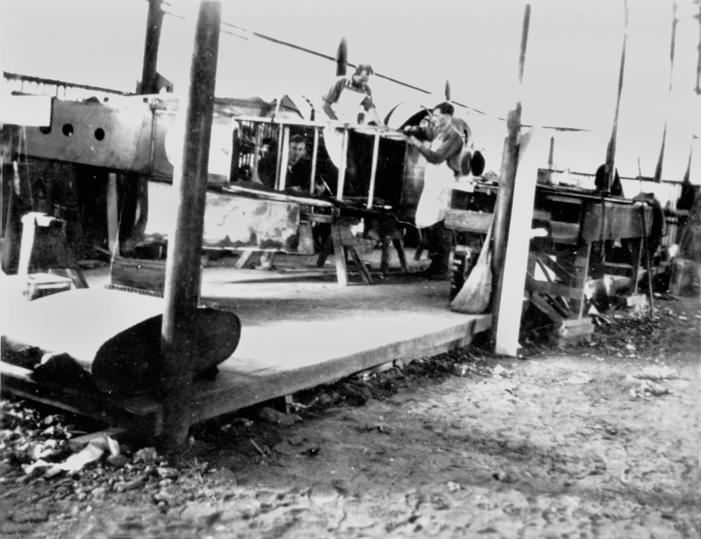
Qantas Hangar, Longreach
Qantas Hangar is a heritage-listed former hangar and now museum at Landsborough Highway, Longreach, Longreach Region, Queensland, Australia. It was built in 1922. It is now part of the Qantas Founders Outback Museum. It was added to the Queensland Heritage Register on 21 October 1992. History The town of Longreach was gazetted in 1887 as the new terminus of the Central Western railway line extending west from Rockhampton. Prior to this, the site of Longreach was a teamsters stop; however the completion of the railway in 1892 provided the impetus for the rapid development of the town. Interest in air transport was accelerated after the First World War. In 1919, the Australian Government offered to the first Australian who completed the flight from England to Australia in twenty-eight days. Two returned pilots, Wilmot Hudson Fysh and Paul Joseph McGinness, with their former flight sergeant Arthur Baird as engineer, were prepared to attempt the flight but had to abandon th ... [...More Info...] [...Related Items...] OR: [Wikipedia] [Google] [Baidu] |
Landsborough Highway
Landsborough Highway is a highway in western Queensland, Australia, running in the northwest–southeast direction from Morven, Queensland, Morven to Cloncurry, Queensland, Cloncurry. The Landsborough Highway runs through vast tracts of land that was once occupied by William Landsborough, an Australian explorer of the 19th century. It is also the central part of the tourist route known as the Matilda Way after the popular Australian song Waltzing Matilda, which extends from Bourke, New South Wales, Bourke in central northern New South Wales to Karumba, Queensland, Karumba on the Gulf of Carpentaria. The entire highway is an important part of the National Highway (Australia), National Highway system linking Darwin, Northern Territory, Darwin and Brisbane: formerly National Route 66 (Cloncurry to Barcaldine) and National Route 71 (Barcaldine to Augathella), Queensland began to convert to the alphanumeric system much of Australia had adopted in the early-2000s and is now designated ... [...More Info...] [...Related Items...] OR: [Wikipedia] [Google] [Baidu] |
Camooweal
Camooweal is an outback town and locality in the City of Mount Isa, Queensland, Australia. The locality is on the Queensland border with the Northern Territory. In the , the locality of Camooweal had a population of 208 people. Geography The locality of Camooweal is in north-western in the Gulf Region bounded by the west by the Northern Territory. The town of Camooweal is located in the south-west corner of the locality. The town is north-west of the city of Mount Isa and east of the Northern Territory border. The Barkly Highway enters the locality from the south ( Barkly), passes from east to west through the town centre (where it is known as Barkly Street) and then exits to the west (Northern Territory). The Georgina River enters the locality from the west (Northern Territory), passes to the immediate west of the town and then exits to south of the locality (Barkly). Lake Francis () and Lake Canellan () are both on the Georgina River and lie to the south-east of the town. L ... [...More Info...] [...Related Items...] OR: [Wikipedia] [Google] [Baidu] |
Charleville, Queensland
Charleville () is a rural town and locality in the Shire of Murweh, Queensland, Australia. In the , the locality of Charleville had a population of 3,335 people. Geography Located in southwestern Queensland, Australia, Charleville is west of Brisbane (the Queensland capital), 616 kilometres (384 mi) west of Toowoomba, 535 kilometres (333 mi) west of Dalby, 393 kilometres (244 mi) west of Miles and 254 kilometres (158 mi) west of Roma. It is the largest town and administrative centre of the Shire of Murweh, which covers an area of 43,905 square kilometres. Charleville is situated on the banks of the Warrego River. Charleville is the terminus for the Warrego Highway which stretches 683 kilometres (424 mi) from Brisbane. The Mitchell Highway also connects Charleville with: * Augathella - 84 kilometres (53 mi) north * Wyandra - 124 kilometres (77 mi) south * Cunnamulla - 198 kilometres (123 mi) south * Bourke - 454 kilometres (282&nb ... [...More Info...] [...Related Items...] OR: [Wikipedia] [Google] [Baidu] |
Country Party Of Australia (1920)
The National Party of Australia, also known as The Nationals or The Nats, is an Australian political party. Traditionally representing graziers, farmers, and regional voters generally, it began as the Australian Country Party in 1920 at a federal level. In 1975 it adopted the name National Country Party, before taking its current name in 1982. A conservative and agrarian party, the Nationals combine social conservatism with agrarian socialist economic policies. Ensuring support for farmers, either through government grants and subsidies or through community appeals, is a major focus of National Party policy. The process for obtaining these funds has come into question in recent years, such as during the Sports Rorts Affair. According to Ian McAllister, the Nationals are the only remaining party from the "wave of agrarian socialist parties set up around the Western world in the 1920s". Federally and to various extents in New South Wales, Victoria and Western Australia, the N ... [...More Info...] [...Related Items...] OR: [Wikipedia] [Google] [Baidu] |


