|
Pythagoreio
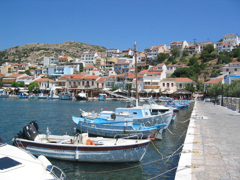
Pythagoreio ( el, Πυθαγόρειο) is a town and municipal unit on the island of Samos, North Aegean, Greece. Before the 2011 local government reform, Pythagoreio was a municipality. Since 2019, it is a municipal unit of East Samos. In 2011, the town's population was 7,996. It is the largest municipal unit in land area on Samos, at . It shares the island with the municipal units of Vathy, Karlovasi, and Marathokampos. The archaeological remains in the town, known collectively as Pythagoreion, has designated a joint UNESCO World Heritage Site with nearby Heraion. The seat of the municipality was the town of Pythagorio, formerly known as Tigani. The town was renamed in 1955 to honour the locally born mathematician and philosopher Pythagoras. The port of the town is considered to be the oldest man-made port of the Mediterranean Sea. History Pythagorio is built on the ancient city of Samos. Some ruins of the ancient city are today incorporated in modern houses of Pythagorio. ... [...More Info...] [...Related Items...] OR: [Wikipedia] [Google] [Baidu] |
Samos
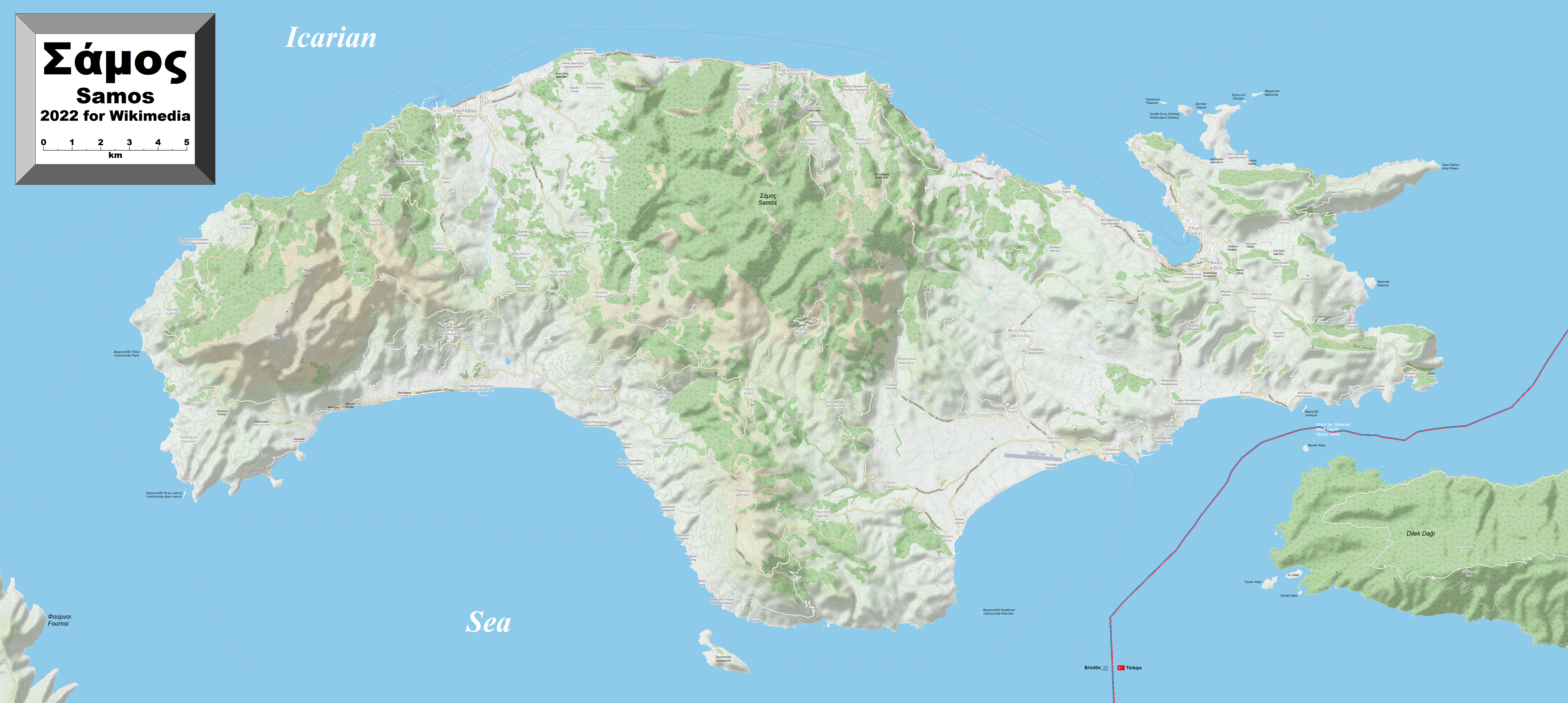
Samos (, also ; el, Σάμος ) is a Greek island in the eastern Aegean Sea, south of Chios, north of Patmos and the Dodecanese, and off the coast of western Turkey, from which it is separated by the -wide Mycale Strait. It is also a separate regional unit of the North Aegean region. In ancient times, Samos was an especially rich and powerful city-state, particularly known for its vineyards and wine production. It is home to Pythagoreion and the Heraion of Samos, a UNESCO World Heritage Site that includes the Eupalinian aqueduct, a marvel of ancient engineering. Samos is the birthplace of the Greek philosopher and mathematician Pythagoras, after whom the Pythagorean theorem is named, the philosophers Melissus of Samos and Epicurus, and the astronomer Aristarchus of Samos, the first known individual to propose that the Earth revolves around the sun. Samian wine was well known in antiquity and is still produced on the island. The island was governed by the semi-autonomous ... [...More Info...] [...Related Items...] OR: [Wikipedia] [Google] [Baidu] |
Pythagoreion
The Pythagoreion is the archaeological site of the ancient town of Samos in Samos, Greece. It is located in the area of the modern town of Pythagoreio, from which it has got its modern name. The archaeological site contains ancient Greek and Roman monuments and a famous ancient tunnel, the Tunnel of Eupalinos or Eupalinian aqueduct. Along with the Heraion of Samos, the Pythagoreion was registered as a UNESCO World Heritage Site in 1992 because of its testimony to the cultural, military, and economic importance of Samos during Archaic and early Classical Greece. History and Description The earliest archeological finds at the site date to the 4th millennium BC, during the Neolithic Period. However, the settlement began around the 16th century BC, when the Minoans colonized Samos. After the Trojan War, the naval and economic importance of Samos grew until its zenith in the 6th century BC. Although it was conquered by the Persians shortly therefore, the town remained an influential ... [...More Info...] [...Related Items...] OR: [Wikipedia] [Google] [Baidu] |
Pythagoreion Harbour
The Pythagoreion is the archaeological site of the ancient town of Samos in Samos, Greece. It is located in the area of the modern town of Pythagoreio, from which it has got its modern name. The archaeological site contains ancient Greek and Roman monuments and a famous ancient tunnel, the Tunnel of Eupalinos or Eupalinian aqueduct. Along with the Heraion of Samos, the Pythagoreion was registered as a UNESCO World Heritage Site in 1992 because of its testimony to the cultural, military, and economic importance of Samos during Archaic and early Classical Greece. History and Description The earliest archeological finds at the site date to the 4th millennium BC, during the Neolithic Period. However, the settlement began around the 16th century BC, when the Minoans colonized Samos. After the Trojan War, the naval and economic importance of Samos grew until its zenith in the 6th century BC. Although it was conquered by the Persians shortly therefore, the town remained an influential ... [...More Info...] [...Related Items...] OR: [Wikipedia] [Google] [Baidu] |
Heraion Of Samos
The Heraion of Samos was a large sanctuary to the goddess Hera, on the island of Samos, Greece, 6 km southwest of the ancient city of Samos (modern Pythagoreion). It was located in the low, marshy basin of the Imbrasos river, near where it enters the sea. The late Archaic temple in the sanctuary was the first of the gigantic free-standing Ionic temples, but its predecessors at this site reached back to the Geometric Period of the 8th century BC, or earlier. As a testimony to the mercantile and naval power of Samos during Archaic Greece, and its exceptional architecture, the site of temple's ruins, with its sole standing column, was designated a UNESCO World Heritage Site, along with the nearby archeological site Pythagoreion in 1992. History The core myth at the heart of the cult of Hera at Samos is that of her birth. According to the local tradition, the goddess was born under a ''lygos'' tree (''Vitex agnus-castus'', the "chaste-tree"). At the annual Samian festival called ... [...More Info...] [...Related Items...] OR: [Wikipedia] [Google] [Baidu] |
Tunnel Of Eupalinos
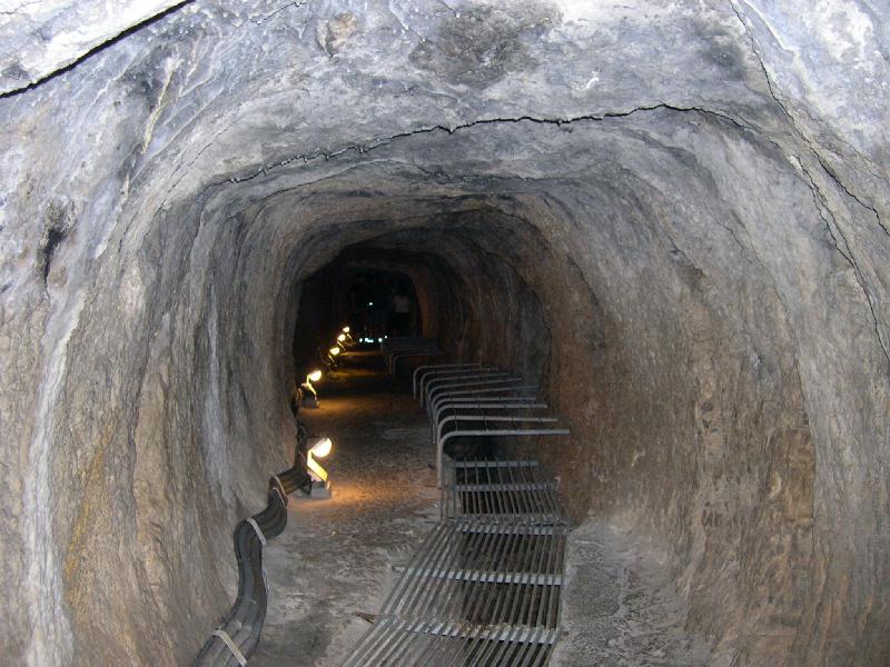
The Tunnel of Eupalinos or Eupalinian aqueduct ( el, Ευπαλίνιον όρυγμα, translit=Efpalinion orygma) is a tunnel of length running through Mount Kastro in Samos, Greece, built in the 6th century BC to serve as an aqueduct. The tunnel is the second known tunnel in history which was excavated from both ends (, "having two openings"), and the first with a geometry-based approach in doing so. Today it is a popular tourist attraction. The tunnel is inscribed on the UNESCO World Heritage List along with the nearby Pythagoreion and Heraion of Samos, and it was designated as an International Historic Civil Engineering Landmark in 2017. Early history The Eupalinian aqueduct is described by Herodotus (''Histories'' 3.60), without whom it might not have been discovered: :I have dwelt longer upon the history of the Samians than I should otherwise have done, because they are responsible for three of the greatest building and engineering feats in the Greek world: the first i ... [...More Info...] [...Related Items...] OR: [Wikipedia] [Google] [Baidu] |
Ancient Harbour Of Samos
The ancient harbour of Samos was located at the town of Samos (modern Pythagoreio) on the island of Samos. It consisted of a large mole, which was identified in the fifth century BC ancient Greek historian Herodotus as one of three greatest feats of engineering in the Greek world.Herodotus, ''Histories'' 3.60 Large parts of the ancient mole seem to survive, partially incorporated into the modern mole, but these remains are very difficult to date. History The island of Samos became one of the major naval powers in the Aegean in the sixth century BC, culminating in the reign of the tyrant Polycrates. In the fifth century, Herodotus reports a mole surrounded the harbour, with a length of more than two stades out to sea (over 400 metres), and reached a depth of twenty orguia (c. 20 metres). The island's political power declined in the fifth century BC. However, the harbour continued to be a major naval base and an important economic hub, especially under Ptolemaic rule during the He ... [...More Info...] [...Related Items...] OR: [Wikipedia] [Google] [Baidu] |
Karlovasi
Karlovasi ( el, Καρλόβασι) is a town, a municipal unit, and a former municipality on the island of Samos, North Aegean, Greece. Since the 2019 local government reform it is part of the municipality West Samos, of which it is a municipal unit and the seat. It is located on the northwest side of the island and it is considered the commercial center of the island. According to the 2011 census, the population of the municipal unit was 9,855 inhabitants. Its land area is 100.330 km2. The municipal unit shares the island of Samos with the municipal units of Vathy, Pythagoreio, and Marathokampos. The School of Sciences of University of the Aegean is located in the town and currently there are three academic departments: * Department of Mathematics * Department of Information and Communication Systems Engineering * Department of Statistics and Actuarial - Financial Mathematics There are over 1,000 active students living in the town throughout the year., by the University of ... [...More Info...] [...Related Items...] OR: [Wikipedia] [Google] [Baidu] |
Marathokampos
Marathokampos ( el, Μαραθόκαμπος) is a town, municipal unit, and a former municipality on the island of Samos, North Aegean, Greece. Since the 2019 local government reform it is part of the municipality West Samos, of which it is a municipal unit. The population is 2,609 (2011 census) and the land area is 87.250 km². It shares the island of Samos with the municipal units of Vathy, Pythagoreio, and Karlovasi Karlovasi ( el, Καρλόβασι) is a town, a municipal unit, and a former municipality on the island of Samos, North Aegean, Greece. Since the 2019 local government reform it is part of the municipality West Samos, of which it is a municipal u .... It is the smallest of the four in both land area and population. Communities The municipal unit contains five communities (κοινότητες, ''koinótites''). References External linksOfficial website Populated places in Samos {{NorthAegean-geo-stub ... [...More Info...] [...Related Items...] OR: [Wikipedia] [Google] [Baidu] |
Polycrates
Polycrates (; grc-gre, Πολυκράτης), son of Aeaces, was the tyrant of Samos from the 540s BC to 522 BC. He had a reputation as both a fierce warrior and an enlightened tyrant. Sources The main source for Polycrates' life and activities is the historian Herodotus, who devotes a large section of book 3 of his '' Histories'' to the rise and fall of Polycrates (3.39-60, 3.120-126). His account was written in the third quarter of the 5th century BC, nearly a century after Polycrates' death, was based mostly on oral traditions and incorporates many folk-tale elements. Furthermore, Herodotus creatively shaped his account of Polycrates in order to make general moral points and to comment on the imperialism of the Athenian empire in his own day. Some poetry from Polycrates' time comments on him in passing and there is a smattering of references to Polycrates in other literary sources ranging in date from the 4th century BC to the Roman Imperial period. These sources preserve u ... [...More Info...] [...Related Items...] OR: [Wikipedia] [Google] [Baidu] |
East Samos
East Samos ( el, Ανατολική Σάμος ''Anatoliki Samos'') is a municipality on the island of Samos in the North Aegean region in Greece. The municipality was formed at the 2019 local government reform, when the pre-existing municipality of Samos was divided in two. Its seat is the town Samos. The municipality consists of the following two subdivisions (municipal units): *Pythagoreio Pythagoreio ( el, Πυθαγόρειο) is a town and municipal unit on the island of Samos, North Aegean, Greece. Before the 2011 local government reform, Pythagoreio was a municipality. Since 2019, it is a municipal unit of East Samos. In 2011, ... * Vathy References {{East Samos div Populated places in Samos 2019 establishments in Greece Municipalities of the North Aegean ... [...More Info...] [...Related Items...] OR: [Wikipedia] [Google] [Baidu] |
North Aegean
The North Aegean Region ( el, Περιφέρεια Βορείου Αιγαίου, translit=Periféria Voríou Eyéou, ) is one of the thirteen administrative regions of Greece, and the smallest of the thirteen by population. It comprises the islands of the north-eastern Aegean Sea, called the North Aegean islands, except for Thasos and Samothrace, which belong to the Greek region of Eastern Macedonia and Thrace, and Imbros and Tenedos, which belong to Turkey. Administration The North Aegean region was established in the 1987 administrative reform. With the 2010 Kallikratis plan, its powers and authority were redefined and extended. Along with the Southern Aegean region, it is supervised by the Decentralized Administration of the Aegean based at Piraeus. The capital of the region is situated in Mytilene on the island of Lesbos. Until the Kallikratis reform, the region consisted of the three prefectures of Samos, Chios and Lesbos. Since 1 January 2011 it is divided into five reg ... [...More Info...] [...Related Items...] OR: [Wikipedia] [Google] [Baidu] |


