|
Preston Hill Country Park
Preston Hill Country Park is in Eynsford, in Kent, England. It is a woodland and former military firing range. Within the site of the park and woodland, stood Preston Hill farmhouse. This was then damaged in 1944 after a 1000 kg parachute bomb or mine was dropped, in the early hours of 22 January 1944. Three of the farmhouse occupants were killed and 8 others were injured, later the ruined farmhouse was demolished. The site was then used as a Ministry of Defence firing range (up to the 1940s); the remnants of the range can still be seen. Since 1951 it has been a Site of Special Scientific Interest (part of ''Otford To Shoreham Downs site''). Preston Hill has extensive views across the countryside from the Darenth Valley (following the River Darent) to Lullingstone Country Park. The site has of chalk grassland and woodland with many wild flowers and rare butterflies at this site of outstanding natural beauty located within the Kent Downs. On the grasslands, a variety ... [...More Info...] [...Related Items...] OR: [Wikipedia] [Google] [Baidu] |
Eynsford
Eynsford ( or ) is a village and civil parish in the Sevenoaks District of Kent, England. It is located south east of Swanley, south of Dartford. The village including its farmland and woods occupies the northern half of the triangle formed by three motorways in west Kent barring its very northernmost part which is Farningham. This area is undulating and has a large minority of woodland. In the south of the parish is Lullingstone, much of which was owned for many centuries by the large, late medieval Lullingstone Castle, whereas other parts of the village were owned by Eynsford Castle, which is older. Well before the founding of the Kingdom of England, Lullingstone Roman villa was founded in this part of the parish, which is open to the public today. The Darent Valley Path takes in a cross-section of the area. The village Eynsford is first mentioned in writing in 864, as "Egenes homme". The derivation is unclear, but one possibility is that it represents "Ægen's river-mead ... [...More Info...] [...Related Items...] OR: [Wikipedia] [Google] [Baidu] |
Vipera Berus
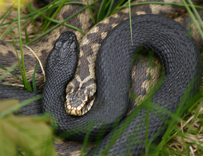
''Vipera berus'', the common European adderMallow D, Ludwig D, Nilson G. (2003). ''True Vipers: Natural History and Toxinology of Old World Vipers''. Malabar, Florida: Krieger Publishing Company. . or common European viper,Stidworthy J. (1974). ''Snakes of the World''. New York: Grosset & Dunlap Inc. 160 pp. . is a venomous snake that is extremely widespread and can be found throughout most of central and eastern Europe and as far as East Asia. Known by a host of common names including common adder and common viper, adders have been the subject of much folklore in Britain and other European countries. They are not regarded as especially dangerous; the snake is not aggressive and usually bites only when really provoked, stepped on, or picked up. Bites can be very painful, but are seldom fatal. The specific name, ''berus'', is New Latin and was at one time used to refer to a snake, possibly the grass snake, ''Natrix natrix''.Gotch AF. (1986). ''Reptiles: Their Latin Names Explaine ... [...More Info...] [...Related Items...] OR: [Wikipedia] [Google] [Baidu] |
Shoreham, Kent
Shoreham is a village and civil parish in the Sevenoaks District of Kent, England. It is located 5.2 miles north of Sevenoaks. The probable derivation of the name is ''estate at the foot of a steep slope''. Steep slope was from the Saxon word ''scor''. pronounced ''shor'', but written ''sore'' by Norman scribes. The village of Shoreham contains three traditional independent pubs: The Samuel Palmer (formally Ye Olde George Inn), The King's Arms and the Crown; with The Rising Sun in nearby Twitton. History The Darent valley was one of the major areas of Stone Age settlement; Shoreham is not mentioned in the Domesday Book. In 1668, cricket was mentioned in a court case as being played at Shoreham, one of the sport's earliest references. It was also known as a smuggling area. Moreover, Shoreham was the most bombed village in the United Kingdom during the Second World War because the Army took over several manor houses for operational use. Papermaking was once a local industry ... [...More Info...] [...Related Items...] OR: [Wikipedia] [Google] [Baidu] |
A225 Road
List of A roads in zone 2 in Great Britain starting south of the River Thames The River Thames ( ), known alternatively in parts as the The Isis, River Isis, is a river that flows through southern England including London. At , it is the longest river entirely in England and the Longest rivers of the United Kingdom, se ... and east of the A3 (roads beginning with 2). __FORCETOC__ Single- and double-digit roads Triple-digit roads Four digit roads {{United Kingdom roads 2 2 ... [...More Info...] [...Related Items...] OR: [Wikipedia] [Google] [Baidu] |
Darenth Valley Viewed From Preston Hill - Geograph
Darenth is a village and civil parish in the Borough of Dartford, Kent, England. It is located 3.4 miles south east of Dartford and 4.6 miles north east of Swanley. History The parish was part of Axstane Hundred and later Dartford Rural District. In the 1870s, Darenth was described as a parish in Dartford district, Kent; on the river Darent, 1½ mile N of Farningham r. station, and 2¼ SSE of Dartford. Demographics According to the 2011 Census, there were 2,398 males and 2,453 females living in the parish. The population in Darenth remains stable, up until 1850. After this point, the population increases gradually, up until 1911, where the population dramatically increases. The boundary for Darenth changed on 1 April 1955, thus explaining the minor fluctuation, the population then went on to reach its peak in 1960, with a total population of 5,127. After this point, the population has steadily declined, with the total population (from the 2011 Census), to be recorded at ... [...More Info...] [...Related Items...] OR: [Wikipedia] [Google] [Baidu] |
Natural England
Natural England is a non-departmental public body in the United Kingdom sponsored by the Department for Environment, Food and Rural Affairs. It is responsible for ensuring that England's natural environment, including its land, flora and fauna, freshwater and marine environments, geology and soils, are protected and improved. It also has a responsibility to help people enjoy, understand and access the natural environment. Natural England focuses its activities and resources on four strategic outcomes: * a healthy natural environment * enjoyment of the natural environment * sustainable use of the natural environment * a secure environmental future Roles and responsibilities As a non-departmental public body (NDPB), Natural England is independent of government. However, the Secretary of State for Environment, Food & Rural Affairs has the legal power to issue guidance to Natural England on various matters, a constraint that was not placed on its predecessor NDPBs. Its powers inc ... [...More Info...] [...Related Items...] OR: [Wikipedia] [Google] [Baidu] |
Green Flag Award
The Green Flag Award is an international accreditation given to publicly accessible parks and open spaces, managed under licence from the Department for Levelling Up, Housing and Communities, a UK Government department, by Keep Britain Tidy, who also administers the scheme in England. History The Green Flag Award was introduced in 1996, and first awarded in 1997, by the Ministry of Housing, Communities and Local Government (MHCLG) with the intention of establishing agreed standards of good management, to help to justify and evaluate funding and to raise park attendance. The scheme was managed by Civic Trust, on MHCLG's behalf, until they lost the contract and the charity went bust in 2009. The scheme has been managed by Keep Britain Tidy since 2012, with sister organisations Keep Scotland Beautiful, Keep Wales Tidy and TIDY Northern Ireland delivering the scheme across the UK, and various other bodies delivering worldwide. Purpose and description The scheme's aim is to pro ... [...More Info...] [...Related Items...] OR: [Wikipedia] [Google] [Baidu] |
North Wales
, area_land_km2 = 6,172 , postal_code_type = Postcode , postal_code = LL, CH, SY , image_map1 = Wales North Wales locator map.svg , map_caption1 = Six principal areas of Wales commonly defined to be North Wales, for policing, fire and rescue, health and regional economy. North Wales ( cy, Gogledd Cymru) is a region of Wales, encompassing its northernmost areas. It borders Mid Wales to the south, England to the east, and the Irish Sea to the north and west. The area is highly mountainous and rural, with Snowdonia National Park ( and the Clwydian Range and Dee Valley (), known for its mountains, waterfalls and trails, wholly within the region. Its population is concentrated in the north-east and northern coastal areas, with significant Welsh-speaking populations in its western and rural areas. North Wales is imprecisely defined, lacking any exact definition or administrative structure. It is commonly defined adminis ... [...More Info...] [...Related Items...] OR: [Wikipedia] [Google] [Baidu] |
Colwyn Bay
Colwyn Bay ( cy, Bae Colwyn) is a town, community and seaside resort in Conwy County Borough on the north coast of Wales overlooking the Irish Sea. It lies within the historic county of Denbighshire. Eight neighbouring communities are incorporated within its postal district. Established as its own separate parish in 1844 with just a small grouping of homes and farms where the community of Old Colwyn stands today, Colwyn Bay has expanded to become the second-largest community and business centre in the north of Wales as well as the 14th largest in the whole of Wales with the urban statistical area, including Old Colwyn, Rhos-on-Sea, and Mochdre and Penrhyn Bay, having a population of 34,284 at the 2011 census. History The western side of Colwyn Bay, Rhos-on-Sea, includes a number of historic sites associated with St Trillo and Ednyfed Fychan, the 13th century general and councillor to Llywelyn the Great. The name 'Colwyn' may be named after 'Collwyn ap Tangno' who was ... [...More Info...] [...Related Items...] OR: [Wikipedia] [Google] [Baidu] |
Great Orme
The Great Orme ( cy, Y Gogarth) is a limestone headland on the north coast of Wales, north-west of the town of Llandudno. Referred to as ''Cyngreawdr Fynydd'' by the 12th-century poet Gwalchmai ap Meilyr, its English name derives from the Old Norse word for sea serpent. The Little Orme, a smaller but very similar limestone headland, is on the eastern side of Llandudno Bay. Toponym Both the Great and Little Ormes have been etymologically linked to the Old Norse words ''urm'' or ''orm'' that mean sea serpent (English ''worm'' is a cognate). One explanation is that the Great Orme is the head, with its body being the land between the Great and Little Ormes, whilst another, possibly more likely, is that the shape of the Great Orme viewed as one enters the isthmus of Llandudno from the southeast landward end resembles a giant sleeping creature. The Vikings left no written texts of their time in North Wales although they certainly raided the area. They did not find any permanent sett ... [...More Info...] [...Related Items...] OR: [Wikipedia] [Google] [Baidu] |
Feral Goats
The feral goat is the domestic goat (''Capra aegagrus hircus'') when it has become established in the wild. Feral goats occur in many parts of the world. Species Feral goats consist of many breeds of goats, all of which stem from the wild goat, ''C. aegagrus''. Although breeds can look different, they all share similar characteristics. Physically, both domestic and feral goats can be identified by their prominent straight horns (more prominent on male goats), rectangular pupils, and coarse hair. In addition, most domesticated goats/feral goats lie around 100 – 120lbs, with heavier goats tending to be wild goats. Behavior The feral goat is seen in Australia, New Zealand, Ireland, Great Britain, Hawaii, Brazil, Honduras, Lebanon, Panama, Madagascar, Comoro Islands, Mauritius, Réunion, New Guinea, the Galapagos, Cuba and in many other parts of the world. When feral goats reach large populations in habitats which are not adapted to them, they may become an invasive species wi ... [...More Info...] [...Related Items...] OR: [Wikipedia] [Google] [Baidu] |
Grass Snake
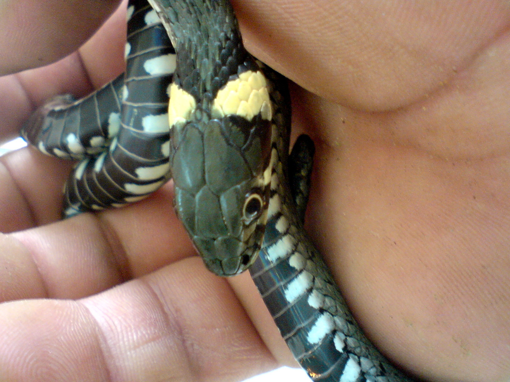
The grass snake (''Natrix natrix''), sometimes called the ringed snake or water snake, is a Eurasian non-venomous colubrid snake. It is often found near water and feeds almost exclusively on amphibians. Subspecies Many subspecies are recognized, including: ''Natrix natrix helvetica'' ( Lacépède, 1789) was formerly treated as a subspecies, but following genetic analysis it was recognised in August 2017 as a separate species, ''Natrix helvetica'', the barred grass snake. Four other subspecies were transferred from ''N. natrix'' to ''N. helvetica'', becoming ''N. helvetica cettii'', ''N. helvetica corsa'', ''N. helvetica lanzai'' and ''N. helvetica sicula''. Description The grass snake is typically dark green or brown in colour with a characteristic yellow or whitish collar behind the head, which explains the alternative name ringed snake. The colour may also range from grey to black, with darker colours being more prevalent in colder regions, ... [...More Info...] [...Related Items...] OR: [Wikipedia] [Google] [Baidu] |


