|
Porter (Martian Crater)
Porter is a large-scale impact crater in the Thaumasia quadrangle on the planet Mars, situated in Aonia Terra at 50.8° south and 113.9º west. The impact caused a bowl across. The name was chosen in 1973 by the International Astronomical Union in honour of the US astronomer and explorer, Russell W. Porter (1871-1949). Impact craters generally have a rim with ejecta around them, in contrast volcanic craters usually do not have a rim or ejecta deposits. As craters get larger (greater than 10 km in diameter) they usually have a central peak. The peak is caused by a rebound of the crater floor following the impact. Wikiporter.jpg, Porter Crater, as seen by CTX camera (on Mars Reconnaissance Orbiter). Gullies are visible in the upper left. Wikiportergullies.jpg, Gullies in Porter Crater, as seen by CTX camera (on Mars Reconnaissance Orbiter). Note: this is an enlargement of the previous photo. See also * Climate of Mars * Geology of Mars * HiRISE * List of crat ... [...More Info...] [...Related Items...] OR: [Wikipedia] [Google] [Baidu] |
Mars Global Surveyor
''Mars Global Surveyor'' (MGS) was an American robotic space probe developed by NASA's Jet Propulsion Laboratory and launched November 1996. MGS was a global mapping mission that examined the entire planet, from the ionosphere down through the atmosphere to the surface. As part of the larger Mars Exploration Program, Mars Global Surveyor performed atmospheric monitoring for sister orbiters during aerobraking, and helped Mars rovers and lander missions by identifying potential landing sites and relaying surface telemetry. It completed its primary mission in January 2001 and was in its third extended mission phase when, on 2 November 2006, the spacecraft failed to respond to messages and commands. A faint signal was detected three days later which indicated that it had gone into safe mode. Attempts to recontact the spacecraft and resolve the problem failed, and NASA officially ended the mission in January 2007. MGS remains in a stable near-polar circular orbit at about 450 km ... [...More Info...] [...Related Items...] OR: [Wikipedia] [Google] [Baidu] |
Mars Reconnaissance Orbiter
''Mars Reconnaissance Orbiter'' (MRO) is a spacecraft designed to study the geology and climate of Mars, provide reconnaissance of future landing sites, and relay data from surface missions back to Earth. It was launched on August 12, 2005, and reached Mars on March 10, 2006. In November 2006, after five months of aerobraking, it entered its final science orbit and began its primary science phase. The cost to develop and operate MRO through the end of its prime mission in 2010 was . The spacecraft continues to operate at Mars, far beyond its intended design life. Due to its critical role as a high-speed data-relay for ground missions, NASA intends to continue the mission as long as possible, at least through the late 2020s. Pre-launch After the twin failures of the ''Mars Climate Orbiter'' and the Mars Polar Lander missions in 1999, NASA reorganized and replanned its Mars Exploration Program. In October 2000, NASA announced its reformulated Mars plans, which reduced the numb ... [...More Info...] [...Related Items...] OR: [Wikipedia] [Google] [Baidu] |
Water On Mars
Almost all water on Mars today exists as ice, though it also exists in small quantities as vapor in the atmosphere. What was thought to be low-volume liquid brines in shallow Martian soil, also called recurrent slope lineae, may be grains of flowing sand and dust slipping downhill to make dark streaks.Recurring Martian Streaks: Flowing Sand, Not Water? Nasa.org 2017-11-20 The only place where water ice is visible at the surface is at the north polar ice cap. Abundant water ice is also present beneath the permanent |
Planetary Nomenclature
Planetary nomenclature, like terrestrial nomenclature, is a system of uniquely identifying features on the surface of a planet or natural satellite so that the features can be easily located, described, and discussed. Since the invention of the telescope, astronomers have given names to the surface features they have discerned, especially on the Moon and Mars. To found an authority on planetary nomenclature, the International Astronomical Union (IAU) was organized in 1919 to designate and standardize names for features on Solar System bodies. How names are approved by the IAU When images are first obtained of the surface of a planet or satellite, a theme for naming features is chosen and a few important features are named, usually by members of the appropriate IAU task group (a commonly accepted planet-naming group). Later, as higher resolution images and maps become available, additional features are named at the request of investigators mapping or describing specific surfaces, ... [...More Info...] [...Related Items...] OR: [Wikipedia] [Google] [Baidu] |
Ore Resources On Mars
Mars may contain ores that would be very useful to colonization of Mars, potential colonists. The abundance of volcanic features together with widespread cratering are strong evidence for a variety of ores. While nothing may be found on Mars that would justify the high cost of transport to Earth, the more ores that future colonists can obtain from Mars, the easier it would be to build colonies there. How deposits are made Ore deposits are produced with the help of large amounts of heat. On Mars, heat can come from molten rock moving under the ground and from crater impacts. Liquid rock under the ground is called magma. When magma sits in underground chambers, slowly cooling over thousands of years, heavier elements sink. These elements, including copper, chromium, iron, and nickel become concentrated at the bottom. When magma is hot, many elements are free to move. As cooling proceeds, the elements bind with each other to form chemical compounds or minerals. Because some elemen ... [...More Info...] [...Related Items...] OR: [Wikipedia] [Google] [Baidu] |
Martian Gullies
Martian gullies are small, incised networks of narrow channels and their associated downslope sediment deposits, found on the planet of Mars. They are named for their resemblance to terrestrial gullies. First discovered on images from Mars Global Surveyor, they occur on steep slopes, especially on the walls of craters. Usually, each gully has a dendritic ''alcove'' at its head, a fan-shaped ''apron'' at its base, and a single thread of incised ''channel'' linking the two, giving the whole gully an hourglass shape. They are estimated to be relatively young because they have few, if any craters. A subclass of gullies is also found cut into the faces of sand dunes, that are themselves considered to be quite young. Linear dune gullies are now considered recurrent seasonal features. Most gullies occur 30 degrees poleward in each hemisphere, with greater numbers in the southern hemisphere. Some studies have found that gullies occur on slopes that face all directions; others have found t ... [...More Info...] [...Related Items...] OR: [Wikipedia] [Google] [Baidu] |
List Of Craters On Mars
__NOTOC__ This is a list of craters on Mars. Impact craters on Mars larger than exist by the hundreds of thousands, but only about one thousand of them have names. Names are assigned by the International Astronomical Union after petitioning by relevant scientists, and in general, only craters that have a significant research interest are given names. Martian craters are named after famous scientists and science fiction authors, or if less than in diameter, after towns on Earth. Craters cannot be named for living people, and names for small craters are rarely intended to commemorate a specific town. Latitude and longitude are given as planetographic coordinates with west longitude. Catalog of named craters The catalog is divided into three partial lists: * List of craters on Mars: A–G * List of craters on Mars: H–N * List of craters on Mars: O–Z Names are grouped into tables for each letter of the alphabet, containing the crater's name (linked if article exists), co ... [...More Info...] [...Related Items...] OR: [Wikipedia] [Google] [Baidu] |
HiRISE
High Resolution Imaging Science Experiment is a camera on board the ''Mars Reconnaissance Orbiter'' which has been orbiting and studying Mars since 2006. The 65 kg (143 lb), US$40 million instrument was built under the direction of the University of Arizona's Lunar and Planetary Laboratory by Ball Aerospace & Technologies Corp. It consists of a 0.5m (19.7 in) aperture reflecting telescope, the largest so far of any deep space mission, which allows it to take pictures of Mars with resolutions of 0.3m/pixel (1ft/pixel), resolving objects below a meter across. HiRISE has imaged Mars exploration rovers on the surface, including the ''Opportunity'' rover and the ongoing ''Curiosity'' mission. History In the late 1980s, of Ball Aerospace & Technologies began planning the kind of high-resolution imaging needed to support sample return and surface exploration of Mars. In early 2001 he teamed up with Alfred McEwen of the University of Arizona to propose such a c ... [...More Info...] [...Related Items...] OR: [Wikipedia] [Google] [Baidu] |
Geology Of Mars
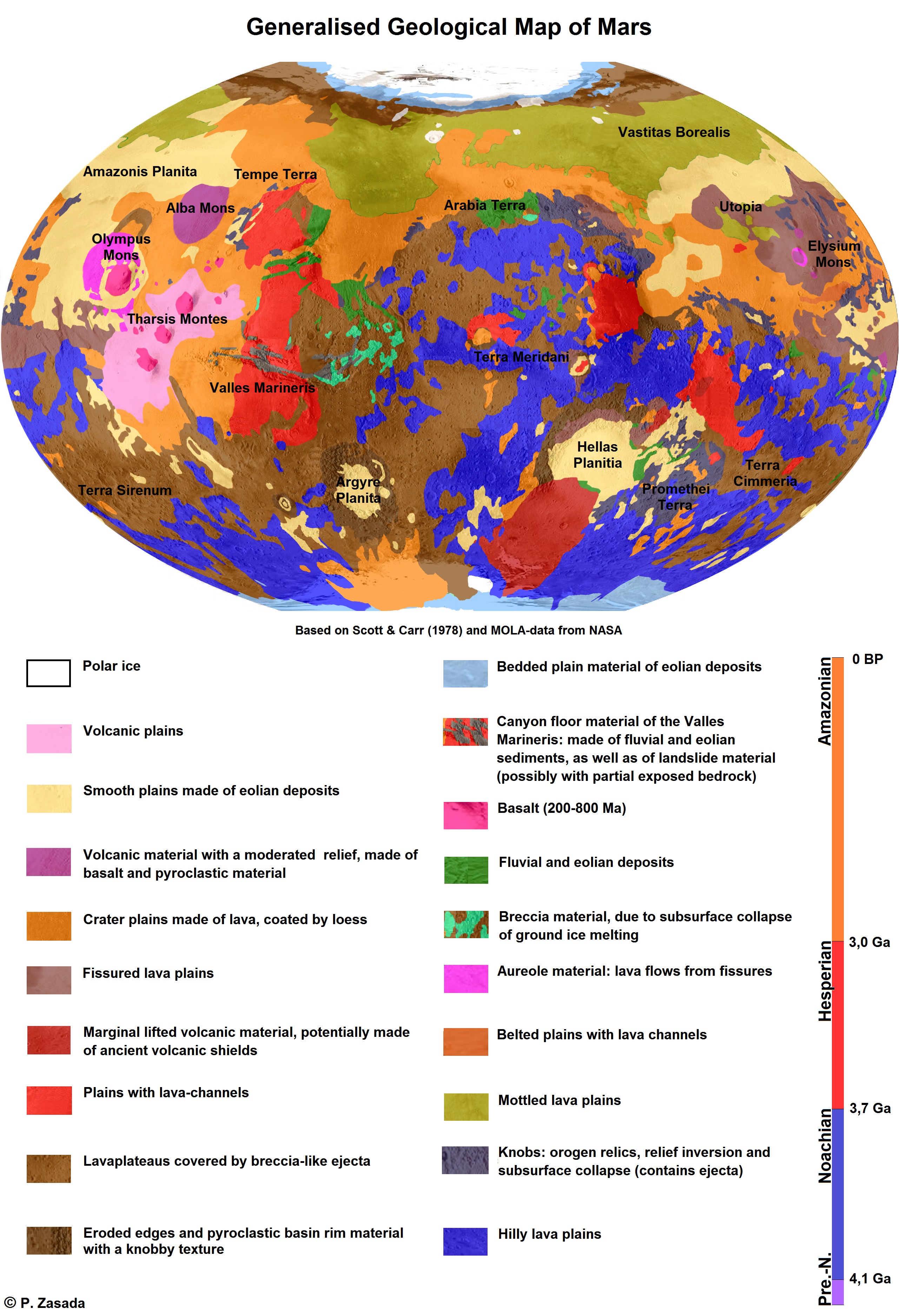
The geology of Mars is the scientific study of the surface, crust, and interior of the planet Mars. It emphasizes the composition, structure, history, and physical processes that shape the planet. It is analogous to the field of terrestrial geology. In planetary science, the term ''geology'' is used in its broadest sense to mean the study of the solid parts of planets and moons. The term incorporates aspects of geophysics, geochemistry, mineralogy, geodesy, and cartography. A neologism, areology, from the Greek word ''Arēs'' (Mars), sometimes appears as a synonym for Mars's geology in the popular media and works of science fiction (e.g. Kim Stanley Robinson, Kim Stanley Robinson's Mars trilogy). The term areology is also used by the Areological Society. Geological map of Mars (2014) File:Geologic Map of Mars figure2.pdf, Figure 2 for the geologic map of Mars Global Martian topography and large-scale features Composition of Mars Mars is a terrestrial planet, whic ... [...More Info...] [...Related Items...] OR: [Wikipedia] [Google] [Baidu] |
Climate Of Mars
The climate of Mars has been a topic of scientific curiosity for centuries, in part because it is the only terrestrial planet whose surface can be directly observed in detail from the Earth with help from a telescope. Although Mars is smaller than the Earth, 11% of Earth's mass, and 50% farther from the Sun than the Earth, its climate has important similarities, such as the presence of polar ice caps, seasonal changes and observable weather patterns. It has attracted sustained study from planetologists and climatologists. While Mars' climate has similarities to Earth's, including periodic ice ages, there are also important differences, such as much lower thermal inertia. Mars' atmosphere has a scale height of approximately , 60% greater than that on Earth. The climate is of considerable relevance to the question of whether life is or ever has been present on the planet. The climate briefly received more interest in the news due to NASA measurements indicating increased sublima ... [...More Info...] [...Related Items...] OR: [Wikipedia] [Google] [Baidu] |
University Of Arizona Press
The University of Arizona Press, a publishing house founded in 1959 as a department of the University of Arizona, is a nonprofit publisher of scholarly and regional books. As a delegate of the University of Arizona to the larger world, the Press publishes the work of scholars wherever they may be, concentrating upon scholarship that reflects the special strengths of the University of Arizona, Arizona State University, and Northern Arizona University. The Press publishes about fifty books annually and has some 1,400 books in print. These include scholarly titles in American Indian studies, anthropology, archaeology, environmental studies, geography, Chicano studies, history, Latin American studies, and the space sciences. The UA Press has award-winning books in more than 30 subject areas. The UA Press also publishes general interest books on Arizona and the Southwest borderlands. In addition, the Press publishes books of personal essays, such as Nancy Mairs's ''Plaintext'' and tw ... [...More Info...] [...Related Items...] OR: [Wikipedia] [Google] [Baidu] |
Mars
Mars is the fourth planet from the Sun and the second-smallest planet in the Solar System, only being larger than Mercury (planet), Mercury. In the English language, Mars is named for the Mars (mythology), Roman god of war. Mars is a terrestrial planet with a thin atmosphere (less than 1% that of Earth's), and has a crust primarily composed of elements similar to Earth's crust, as well as a core made of iron and nickel. Mars has surface features such as impact craters, valleys, dunes and polar ice caps. It has two small and irregularly shaped moons, Phobos (moon), Phobos and Deimos (moon), Deimos. Some of the most notable surface features on Mars include Olympus Mons, the largest volcano and List of tallest mountains in the Solar System, highest known mountain in the Solar System and Valles Marineris, one of the largest canyons in the Solar System. The North Polar Basin (Mars), Borealis basin in the Northern Hemisphere covers approximately 40% of the planet and may be a la ... [...More Info...] [...Related Items...] OR: [Wikipedia] [Google] [Baidu] |


