|
Poltross Burn
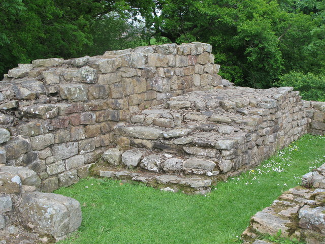
The Poltross Burn is a tributary of the River Irthing. The burn rises on Denton Fell and flows north-east, joining the Irthing at Gilsland. The well-preserved Roman Empire, Roman Milecastle 48, a feature of Hadrian's Wall once known locally as The King's Stables, stands on the west bank. It is signposted as Poltross Burn Milecastle, and adjoins the south side of the railway embankment in Gilsland. A 19th-century watermill within the village used the burn as a source of power to grind corn. See also *Gilsland Rivers of Cumbria {{England-river-stub ... [...More Info...] [...Related Items...] OR: [Wikipedia] [Google] [Baidu] |
River Irthing
The River Irthing is a river in Cumbria, England and a major tributary of the River Eden. The name is recorded as Ard or Arden in early references. For the first 15 miles of its course it defines the border between Northumberland and Cumbria. Etymology The name ''Irthing'' may be of Brittonic origin, though its precise etymology is uncertain. The last part of the name is from ''–ïnn'', an adjectival and, in place-names, toponymic suffix, added to nouns or adjectives. The first part may be ''arth'', meaning "a bear" (c.f. Welsh ''arth''). Or else, the first part of the name could either one of two elements suffixed with ''-ed'', an early Celtic nominal suffix meaning "having the quality of..". The first of these is, ''*ar'', an ancient river-naming element implying either horizontal motion, "flowing", or else "rising" or "springing up" (compare '' Irt''). The second possibility is ''*īr'', meaning "fresh, clean, pure". Geography It is thought that before the last glac ... [...More Info...] [...Related Items...] OR: [Wikipedia] [Google] [Baidu] |
Gilsland
Gilsland is a village in northern England about west of Hexham, and about east of Carlisle, which straddles the border between Cumbria and Northumberland. The village provides an amenity centre for visitors touring Hadrian's Wall and other features of historical interest in this area of rugged Border country, popularised by the Romantic novelist Sir Walter Scott. Its unusual arrangement of incorporating two county councils and three civil parish councils is due to the gradual amalgamation of hamlets during the 19th century. It has a population of about 400, most of whom live on the Northumberland side of the River Irthing and Poltross Burn. History As in most areas of Britain, Bronze-Age and Iron-Age settlement in Northumberland is represented by cup and ring marked stones, standing stones and hill forts, though few such monuments, with the possible exception of the Popping Stone, have been found near Gilsland. Recent field-walking activities by a local archaeology group h ... [...More Info...] [...Related Items...] OR: [Wikipedia] [Google] [Baidu] |
Roman Empire
The Roman Empire ( la, Imperium Romanum ; grc-gre, Βασιλεία τῶν Ῥωμαίων, Basileía tôn Rhōmaíōn) was the post-Republican period of ancient Rome. As a polity, it included large territorial holdings around the Mediterranean Sea in Europe, North Africa, and Western Asia, and was ruled by emperors. From the accession of Caesar Augustus as the first Roman emperor to the military anarchy of the 3rd century, it was a Principate with Italia as the metropole of its provinces and the city of Rome as its sole capital. The Empire was later ruled by multiple emperors who shared control over the Western Roman Empire and the Eastern Roman Empire. The city of Rome remained the nominal capital of both parts until AD 476 when the imperial insignia were sent to Constantinople following the capture of the Western capital of Ravenna by the Germanic barbarians. The adoption of Christianity as the state church of the Roman Empire in AD 380 and the fall of the Western ... [...More Info...] [...Related Items...] OR: [Wikipedia] [Google] [Baidu] |
Milecastle 48
Milecastle 48 (Poltross Burn), is a milecastle on Hadrian's Wall (). Its remains lie near the village of Gilsland in Cumbria where it was historically known as "The King's Stables", owing to the well-preserved interior walls. Unusually a substantial section of stone stairs has survived within the milecastle. The two turrets associated with this milecastle have also survived as above-ground masonry. Description Milecastle 48 is just outside the village of Gilsland in Cumbria, immediately adjacent to the Tyne Valley railway line on its south side ().MILECASTLE 48 Pastscape, retrieved 4 December 2013 It had been known locally as "The King's Stables"Gibson, J.P. & Simpson, F.G. 1911. "The Milecastle on the Wall of Hadrian at the Poltross Burn"; ''Trans. CWAAS XI (New Series)'' Art XXIII pp390–461 fo ... [...More Info...] [...Related Items...] OR: [Wikipedia] [Google] [Baidu] |
Hadrian's Wall
Hadrian's Wall ( la, Vallum Aelium), also known as the Roman Wall, Picts' Wall, or ''Vallum Hadriani'' in Latin, is a former defensive fortification of the Roman province of Britannia, begun in AD 122 in the reign of the Emperor Hadrian. Running from Wallsend on the River Tyne in the east to Bowness-on-Solway in the west of what is now northern England, it was a stone wall with large ditches in front of it and behind it that crossed the whole width of the island. Soldiers were garrisoned along the line of the wall in large forts, smaller milecastles and intervening turrets. In addition to the wall's defensive military role, its gates may have been customs posts. A significant portion of the wall still stands and can be followed on foot along the adjoining Hadrian's Wall Path. The largest Roman archaeological feature in Britain, it runs a total of in northern England. Regarded as a British cultural icon, Hadrian's Wall is one of Britain's major ancient tourist attract ... [...More Info...] [...Related Items...] OR: [Wikipedia] [Google] [Baidu] |


