|
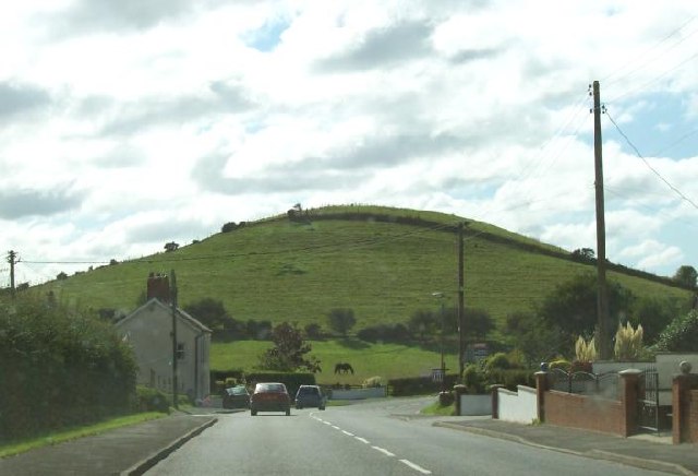
Penparc
Penparc (also known as Penyparc) is a village in Ceredigion, Wales, on the A487 road northeast of Cardigan. The surrounding land is principally used for cattle grazing although the significant glacial sand deposits are also commercially used as a source of sand and gravel. To the east of the village, near a prominent conical hill, is the site of the Battle of Crug Mawr The Battle of Crug Mawr ('Great Barrow'), sometimes referred to as the Battle of Cardigan, took place in September or October 1136, as part of a struggle between the Welsh and Normans for control of Ceredigion, West Wales. The battle was foug ..., fought in 1136. References Villages in Ceredigion {{Ceredigion-geo-stub ... [...More Info...] [...Related Items...] OR: [Wikipedia] [Google] [Baidu] |
Battle Of Crug Mawr
The Battle of Crug Mawr ('Great Barrow'), sometimes referred to as the Battle of Cardigan, took place in September or October 1136, as part of a struggle between the Welsh and Normans for control of Ceredigion, West Wales. The battle was fought near Penparc, northeast of Cardigan, probably on the hill now known as Banc-y-Warren; it resulted in a rout of the Norman forces, setting back their expansion in West Wales for some years. Background A Welsh revolt against Norman rule had begun in South Wales, where on 1 January 1136 the Welsh won a victory over the local Norman forces at the Battle of Llwchwr between Loughor and Swansea, killing about 500 of their opponents. Richard Fitz Gilbert de Clare, the Norman lord of Ceredigion, had been away from his lordship in the early part of the year. Returning to the borders of Wales in April, he ignored warnings of the danger and pressed on towards Ceredigion with a small force. He had not gone far when he was ambushed and killed by ... [...More Info...] [...Related Items...] OR: [Wikipedia] [Google] [Baidu] |
Ceredigion
Ceredigion ( , , ) is a county in the west of Wales, corresponding to the historic county of Cardiganshire. During the second half of the first millennium Ceredigion was a minor kingdom. It has been administered as a county since 1282. Ceredigion is considered a centre of Welsh culture and just under half of the population can speak Welsh according to the 2011 Census. The county is mainly rural, with over of coastline and a mountainous hinterland. The numerous sandy beaches and the long-distance Ceredigion Coast Path provide views of Cardigan Bay. In the 18th and early 19th centuries, Cardiganshire had more industry than it does today; Cardigan was the commercial centre of the county; lead, silver and zinc were mined and Cardigan was the principal port of South Wales prior to the silting of its harbour. The economy became highly dependent on dairy farming and the rearing of livestock for the English market. During the 20th century, livestock farming became less profitable ... [...More Info...] [...Related Items...] OR: [Wikipedia] [Google] [Baidu] |
A487
The A487, officially the Fishguard to Bangor Trunk Road, is a trunk road in Wales that follows the coast from Haverfordwest, Pembrokeshire, in the south, to Bangor, Gwynedd, in the north. Route The road starts at a junction with the A40 in Haverfordwest and travels northwest to St David's to switch northeast through Fishguard, Cardigan, Aberaeron, Aberystwyth, Machynlleth and Corris. Through the town of Fishguard, the road width in places is a very narrow single lane, leading to many traffic issues, especially with heavy goods vehicles (HGVs). From 2010, articulated HGVs were diverted from the section between Cardigan and Fishguard because of this, and routed instead via the A478 road to Penblewin, then the A40 to Fishguard via Haverfordwest. However, there were still problems to some extent. The road continues to Dolgellau multiplexing with the A470 north of the Cross Foxes inn. After Dolgellau, the road continues to multiplex with the A470, re-emerging just north of Tra ... [...More Info...] [...Related Items...] OR: [Wikipedia] [Google] [Baidu] |
Cardigan, Ceredigion
Cardigan ( cy, Aberteifi, ) is both a town and a community in the county of Ceredigion, Wales. Positioned on the tidal reach of the River Teifi at the point where Ceredigion meets Pembrokeshire, Cardigan was the county town of the historic county of Cardiganshire. Cardigan is the second-largest town in Ceredigion. The largest town, Aberystwyth, is one of the two administrative centres; the other is Aberaeron. The settlement at Cardigan was developed around the Norman castle built in the late 11th or early 12th century. The castle was the location of the first National Eisteddfod in 1176. The town became an important port in the 18th century, but declined by the early 20th century owing to its shallow harbour. The castle underwent restoration in 2014. The population in 2001 was 4,203, reducing slightly to 4,184 at the 2011 census. Toponymy Cardigan is an anglicisation of the Welsh ' ("Ceredig's land"), the surrounding territory its Norman castle once controlled. Ceredig ... [...More Info...] [...Related Items...] OR: [Wikipedia] [Google] [Baidu] |


