|
Path 26
Path 26 is a set of three Southern California Edison (SCE) 500 kV power lines, located primarily in Los Angeles County, and extending into Kern and Ventura counties, all in California. Path 26 is part of the Western Electricity Coordinating Council's links of electrical intertie paths in the western United States. The Path 26 lines are located in: the San Joaquin Valley of the southern Central Valley; the Tehachapi Mountains and other central Transverse Ranges; and the Antelope Valley section of the Mojave Desert. Power grids link Path 26 forms Southern California Edison's (SCE) intertie (link) with Pacific Gas & Electric (PG&E) to the north. Since PG&E's power grid and SCE's grid both have interconnections to elsewhere, in the Pacific Northwest (PG&E) and the Southwestern United States (SCE), Path 26 is a southern extension of Path 15 and Path 66, and a crucial link between the two regions' grids. Transmission lines The path consists of three transmission lines, Midway&ndas ... [...More Info...] [...Related Items...] OR: [Wikipedia] [Google] [Baidu] |
Path 27
Path 27, also called the Intermountain or the Southern Transmission System (STS), is a high-voltage direct current (HVDC) electrical transmission line running from the coal-fired Intermountain Power Plant near Delta, Utah to the Adelanto Converter Station at Adelanto, California, in the Southwestern United States. It was installed by the ABB Group, a company based in Switzerland, and commercialized in July 1986. The system is designed to carry power generated at the power plant in Utah to areas throughout Southern California. It is owned and operated by the Intermountain Power Agency, a cooperative consisting of six Los Angeles-area cities, the largest member being the Los Angeles Department of Water and Power (LADWP), and 29 smaller Utah municipalities. Path 27 consists of an overhead power line long, and is capable of transferring up to 2,400 megawatts (MW) of power at ±500 kilovolts (kV), higher than the power plant's operational capacity of 1,900 MW. The resulting max ... [...More Info...] [...Related Items...] OR: [Wikipedia] [Google] [Baidu] |
Pacific Gas & Electric
The Pacific Gas and Electric Company (PG&E) is an American investor-owned utility (IOU). The company is headquartered in the Pacific Gas & Electric Building, in San Francisco, California. PG&E provides natural gas and electricity to 5.2 million households in the northern two-thirds of California, from Bakersfield and northern Santa Barbara County, almost to the Oregon and Nevada state lines. Overseen by the California Public Utilities Commission, PG&E is the leading subsidiary of the holding company PG&E Corporation, which has a market capitalization of $3.242 billion as of January 16, 2019. PG&E was established on October 10, 1905 from the merger and consolidation of predecessor utility companies, and by 1984 was the United States' "largest electric utility business". PG&E is one of six regulated, investor-owned electric utilities (IOUs) in California; the other five are PacifiCorp, Southern California Edison, San Diego Gas & Electric, Bear Valley Electric, and Liberty Utili ... [...More Info...] [...Related Items...] OR: [Wikipedia] [Google] [Baidu] |
Img0288SCE 500kV
img or IMG is an abbreviation for image. img or IMG may also refer to: * IMG (company), global sports and media business headquartered in New York City but with its main offices in Cleveland, originally known as the "International Management Group", with divisions including: ** IMG Academy, an athletic training complex in Bradenton, Florida with facilities for multiple sports ** IMG Artists, a performing arts management company with multiple worldwide offices ** IMG College, a college sports marketing agency based in Winston-Salem, North Carolina ** IMG Models, a modeling agency based in New York * IMG (file format), the file extension of several different disk image formats which store a full digital representation (image) of disk drive or storage media * IMG, a prefix for camera image file names commonly used in Design rule for Camera File system * mg/code>, a tag used in BBCode to place an image * , an HTML element used to place an image; see * IMG Worlds of Adventure, the l ... [...More Info...] [...Related Items...] OR: [Wikipedia] [Google] [Baidu] |
San Onofre Nuclear Generating Station
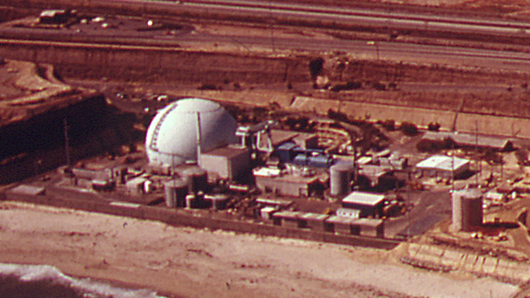
The San Onofre Nuclear Generating Station (SONGS) is a permanently closed nuclear power plant located south of San Clemente, California, on the Pacific coast, in Nuclear Regulatory Commission Region IV. The plant was shut down in 2013 after replacement steam generators failed; it is currently in the process of decommissioning. The 2.2 GW of electricity supply lost when the plant shut down was replaced with 1.8 GW of new natural-gas fired power plants and 250 MW of energy storage projects. The plant is owned by Southern California Edison. Edison International, parent of SCE, holds 78.2% ownership in the plant; San Diego Gas & Electric Company, 20%; and the City of Riverside Utilities Department, 1.8%. When fully functional, it employed over 2,200 people. Located between the ocean and Interstate 5, the station is a prominent landmark because of its twin hemispherical containment buildings, which were designed to contain any unexpected releases of radioactive material from the p ... [...More Info...] [...Related Items...] OR: [Wikipedia] [Google] [Baidu] |
Diablo Canyon Power Plant
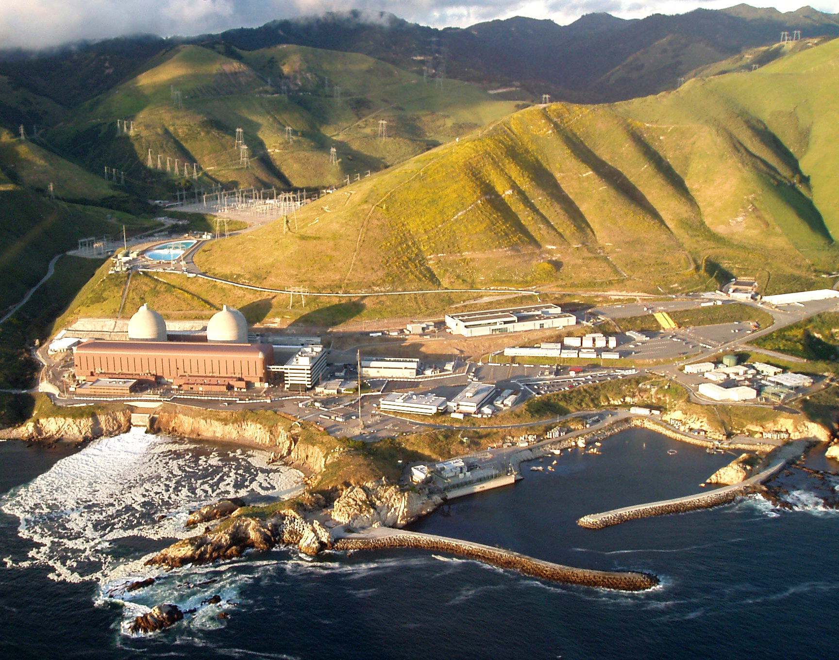
The Diablo Canyon Power Plant is a nuclear power plant near Avila Beach in San Luis Obispo County, California. Since the permanent shutdown of the San Onofre Nuclear Generating Station in 2013, Diablo Canyon has been the only operational nuclear plant and largest single power station in California. It was the subject of controversy and protests during its construction, with nearly two thousand civil disobedience arrests in a two-week period in 1981. The plant has two Westinghouse-designed 4-loop pressurized-water nuclear reactors operated by Pacific Gas & Electric (PG&E). Together, the twin 1100 MWe reactors produce about 18,000 GW·h of electricity annually (8.6% of total California generation and 23% of carbon-free generation), supplying the electrical needs of more than 3 million people. The plant produces electricity for about 6 cents per kWh, less than the average cost of 10.1 cents per kWh that PG&E paid for electricity from other suppliers in 2014. Thou ... [...More Info...] [...Related Items...] OR: [Wikipedia] [Google] [Baidu] |
Washington (state)
Washington (), officially the State of Washington, is a state in the Pacific Northwest region of the Western United States. Named for George Washington—the first U.S. president—the state was formed from the western part of the Washington Territory, which was ceded by the British Empire in 1846, by the Oregon Treaty in the settlement of the Oregon boundary dispute. The state is bordered on the west by the Pacific Ocean, Oregon to the south, Idaho to the east, and the Canadian province of British Columbia to the north. It was admitted to the Union as the 42nd state in 1889. Olympia is the state capital; the state's largest city is Seattle. Washington is often referred to as Washington state to distinguish it from the nation's capital, Washington, D.C. Washington is the 18th-largest state, with an area of , and the 13th-most populous state, with more than 7.7 million people. The majority of Washington's residents live in the Seattle metropolitan area, the center of trans ... [...More Info...] [...Related Items...] OR: [Wikipedia] [Google] [Baidu] |
Oregon
Oregon () is a U.S. state, state in the Pacific Northwest region of the Western United States. The Columbia River delineates much of Oregon's northern boundary with Washington (state), Washington, while the Snake River delineates much of its eastern boundary with Idaho. The 42nd parallel north, 42° north parallel delineates the southern boundary with California and Nevada. Oregon has been home to many Indigenous peoples of the Americas, indigenous nations for thousands of years. The first European traders, explorers, and settlers began exploring what is now Oregon's Pacific coast in the early-mid 16th century. As early as 1564, the Spanish expeditions to the Pacific Northwest, Spanish began sending vessels northeast from the Philippines, riding the Kuroshio Current in a sweeping circular route across the northern part of the Pacific. In 1592, Juan de Fuca undertook detailed mapping and studies of ocean currents in the Pacific Northwest, including the Oregon coast as well as ... [...More Info...] [...Related Items...] OR: [Wikipedia] [Google] [Baidu] |
Electric Power
Electric power is the rate at which electrical energy is transferred by an electric circuit. The SI unit of power is the watt, one joule per second. Standard prefixes apply to watts as with other SI units: thousands, millions and billions of watts are called kilowatts, megawatts and gigawatts respectively. A common misconception is that electric power is bought and sold, but actually electrical energy is bought and sold. For example, electricity is sold to consumers in kilowatt-hours (kilowatts multiplied by hours), because energy is power multiplied by time. Electric power is usually produced by electric generators, but can also be supplied by sources such as electric batteries. It is usually supplied to businesses and homes (as domestic mains electricity) by the electric power industry through an electrical grid. Electric power can be delivered over long distances by transmission lines and used for applications such as motion, light or heat with high efficiency. ... [...More Info...] [...Related Items...] OR: [Wikipedia] [Google] [Baidu] |
Watt
The watt (symbol: W) is the unit of power or radiant flux in the International System of Units (SI), equal to 1 joule per second or 1 kg⋅m2⋅s−3. It is used to quantify the rate of energy transfer. The watt is named after James Watt (1736–1819), an 18th-century Scottish inventor, mechanical engineer, and chemist who improved the Newcomen engine with his own steam engine in 1776. Watt's invention was fundamental for the Industrial Revolution. Overview When an object's velocity is held constant at one metre per second against a constant opposing force of one newton, the rate at which work is done is one watt. : \mathrm In terms of electromagnetism, one watt is the rate at which electrical work is performed when a current of one ampere (A) flows across an electrical potential difference of one volt (V), meaning the watt is equivalent to the volt-ampere (the latter unit, however, is used for a different quantity from the real power of an electrical circuit). : ... [...More Info...] [...Related Items...] OR: [Wikipedia] [Google] [Baidu] |
Tehachapi Renewable Transmission Project
The Tehachapi Renewable Transmission Project is a project involving the construction of approximately of new and upgraded high-voltage transmission lines for transmission of electricity from wind farms and other generating units in southeastern Kern County, California to Los Angeles County and San Bernardino County. The project, developed and operated by Southern California Edison, commenced construction on March 7, 2008 and was completed and placed in operation in December 2016. With a capacity of 4,500 megawatts, the transmission system can provide power for an estimated 3 million homes. It passes through sections of the Tehachapi Mountains, Sierra Pelona Mountains, and Antelope Valley. State laws requiring SCE to provide at least 33% of its power service from renewable sources by 2020 is driving the project. SCE had no interest in owning the land that the project is on, but needed to construct the transmission system nonetheless to meet the renewable source laws ... [...More Info...] [...Related Items...] OR: [Wikipedia] [Google] [Baidu] |
Path 66
California Oregon Intertie (COI), identified as Path 66 by Western Electricity Coordinating Council (WECC), is a corridor of three roughly parallel 500 kV alternating current power lines connecting the electric grids of Oregon and California. Their combined power transmission capacity is 4800 MW. Two of the power lines run from Malin Substation southeast of Klamath Falls, Oregon to Round Mountain Substation northeast of Redding, California. One of them is owned by Western Area Power Administration, the other by Pacific Gas and Electric and PacifiCorp jointly. These lines are a part of Pacific AC Intertie and were completed in the 1960s. The third line runs from Captain Jack Substation near Malin to Olinda Substation south of Redding. It is a part of California-Oregon Transmission Project, the project manager is the Transmission Agency of Northern California (TANC), a joint venture of several public utilities. It was completed in 1993. Route Path 66 is composed of one segme ... [...More Info...] [...Related Items...] OR: [Wikipedia] [Google] [Baidu] |
Path 15
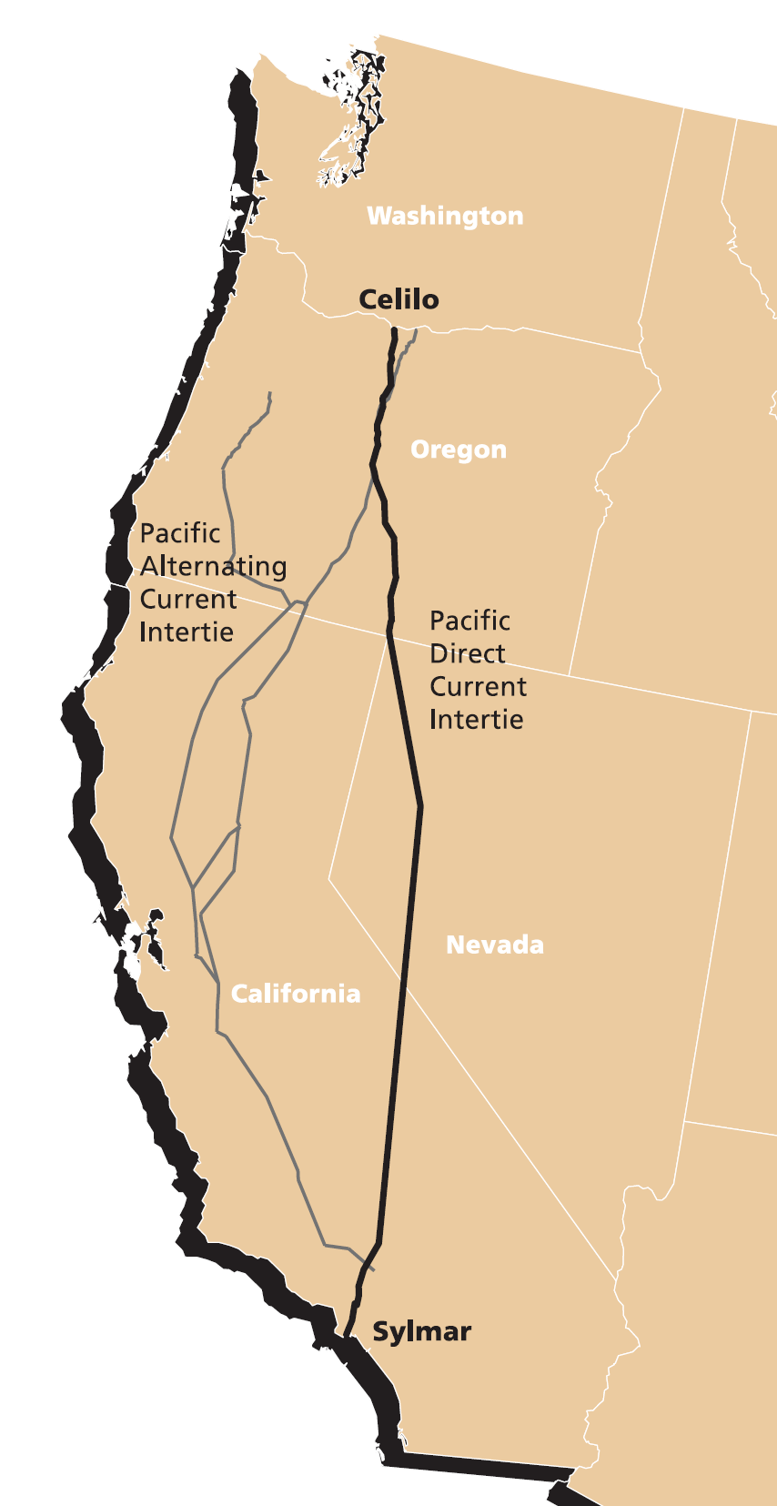
Path 15 is an portion of the north–south power transmission corridor in California, U.S. It forms a part of the Pacific AC Intertie and the California-Oregon Transmission Project. Path 15 is part of The Western Electricity Coordinating Council's links of electrical intertie paths in the western United States. Path 15, along with the Pacific DC Intertie running far to the east, forms an important transmission interconnection with the hydroelectric plants to the north and the fossil fuel plants to the south. Most of the three AC 500 kV lines were built by Pacific Gas and Electric (PG&E) south of Tesla substation. Path 15 consists of three lines at 500 kV and four lines at 230 kV. The 500 kV lines connect Los Banos to Gates and Los Banos to Midway. All four 230 kV lines have Gates at one end with the other ends at Panoche, Gregg, and McCall. There are only two connecting PG&E lines north of Tracy substation that connect Path 15 to Path 66 at the Round Mountain subs ... [...More Info...] [...Related Items...] OR: [Wikipedia] [Google] [Baidu] |


.jpg)

