|
Pashtun Zarghun District
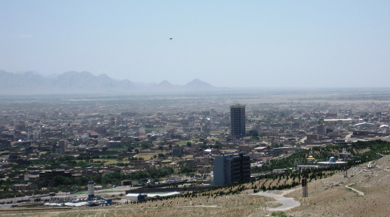
Pashtun Zarghun District ( ps, پښتون زرغون ولسوالی / fa, ولسوالی پشتون زرغون), formerly known as Posht-e Zirghān or Posht-e Zirghūn ( fa, پشت زرغون), is situated in the central part of Herat Province, Afghanistan in the valley of the Hari River. The district center is Pashtun Zarghun. Geography Pashtun Zarghun District borders Karukh District to the North, Obe District to the east, Adraskan District to the south and Guzara District Guzara (Gozareh) District ( fa, ولسوالی گذره) is situated in the center of Herat Province, Afghanistan, 10 km south of Herat. It borders Injil District to the north, Pashtun Zarghun District to the east, Adraskan District to th ... to the west. Population The estimated population of Khoshi District in 2008 was roughly 90,817. Education In 2008, there were around 4 high schools and 20 secondary schools in the district. References External linksDistrict Map Districts of H ... [...More Info...] [...Related Items...] OR: [Wikipedia] [Google] [Baidu] |
Provinces Of Afghanistan
Afghanistan is divided into 34 provinces (, '' wilåyat''). The provinces of Afghanistan are the primary administrative divisions. Each province encompasses a number of districts or usually over 1,000 villages. Provincial governors played a critical role in the reconstruction of the Afghan state following the creation of the new government under Hamid Karzai. According to international security scholar Dipali Mukhopadhyay, many of the provincial governors of the western-backed government were former warlords who were incorporated into the political system. Provinces of Afghanistan Regions of Afghanistan UN Regions Former provinces of Afghanistan During Afghanistan's history it had a number of provinces in it. It started out as just Kabul, Herat, Qandahar, and Balkh but the number of provinces increased and by 1880 the provinces consisted of Balkh, Herat, Qandahar, Ghazni, Jalalabad, and Kabul. * Southern Province – dissolved in 1964 to create Paktia Provinc ... [...More Info...] [...Related Items...] OR: [Wikipedia] [Google] [Baidu] |
Herat Province
Herat (Persian: ) is one of the thirty-four provinces of Afghanistan, located in the north-western part of the country. Together with Badghis, Farah, and Ghor provinces, it makes up the north-western region of Afghanistan. Its primary city and administrative capital is Herat City. The province of Herat is divided into about 17 districts and contains over 2,000 villages. It has a population of about 3,780,000, making it the second most populated province in Afghanistan behind Kabul Province. The population is multi-ethnic but largely Persian-speaking. Herat dates back to the Avestan times and was traditionally known for its wine. The city has a number of historic sites, including the Herat Citadel and the Musalla Complex. During the Middle Ages Herat became one of the important cities of Khorasan, as it was known as the Pearl of Khorasa The province of Herat shares a border with Iran in the west and Turkmenistan in the north, making it an important trading region. The Trans-Afg ... [...More Info...] [...Related Items...] OR: [Wikipedia] [Google] [Baidu] |
Afghanistan
Afghanistan, officially the Islamic Emirate of Afghanistan,; prs, امارت اسلامی افغانستان is a landlocked country located at the crossroads of Central Asia and South Asia. Referred to as the Heart of Asia, it is bordered by Pakistan to the Durand Line, east and south, Iran to the Afghanistan–Iran border, west, Turkmenistan to the Afghanistan–Turkmenistan border, northwest, Uzbekistan to the Afghanistan–Uzbekistan border, north, Tajikistan to the Afghanistan–Tajikistan border, northeast, and China to the Afghanistan–China border, northeast and east. Occupying of land, the country is predominantly mountainous with plains Afghan Turkestan, in the north and Sistan Basin, the southwest, which are separated by the Hindu Kush mountain range. , Demographics of Afghanistan, its population is 40.2 million (officially estimated to be 32.9 million), composed mostly of ethnic Pashtuns, Tajiks, Hazaras, and Uzbeks. Kabul is the country's largest city and ser ... [...More Info...] [...Related Items...] OR: [Wikipedia] [Google] [Baidu] |
Hari River, Afghanistan
The Hari River ( or prs, هری رود, translit=Harī Rōd; ps, د هري سیند) or Herat River is a river flowing from the mountains of central Afghanistan to Turkmenistan, where it forms the Tejend oasis and disappears in the Karakum Desert. In its lower course, the river forms a northern part of the border between Afghanistan and Iran, and a southeastern part of the border between Turkmenistan and Iran. In Turkmenistan it is known as the Tejen or Tedzhen river and passes close to the city of Tedzhen. To the Ancient Greeks it was known as the Arius. In Latin, it was known as the Tarius. History Western non Hindu writers claim that Rigveda is said to have recorded the Harirud as the River Sarayu. However, the actual Sarayu is in Uttar Pradesh state of India and arises in Tibetan glaciers near Mt Kailash. It flows through Nepal, before entering India . The river Haroyu is also mentioned in the Avesta. A Buddhist monastery hand-carved in the bluff of the river Harirud ex ... [...More Info...] [...Related Items...] OR: [Wikipedia] [Google] [Baidu] |
Pashtun Zarghun
Pashtun Zarghun is located at 1042 m altitude at the center of the Pashtun Zarghun District and is situated in its central part. References See also *Herat Province Herat ( Persian: ) is one of the thirty-four provinces of Afghanistan, located in the north-western part of the country. Together with Badghis, Farah, and Ghor provinces, it makes up the north-western region of Afghanistan. Its primary city a ... Populated places in Herat Province {{Herat-geo-stub ... [...More Info...] [...Related Items...] OR: [Wikipedia] [Google] [Baidu] |
Karukh District
Karukh District is situated in the northeastern part of Herat Province, Afghanistan. It borders Kushk District to the northwest, Kushki Kuhna District to the north and Badghis Province to the northeast. To the east is Obe District. To the south is Pashtun Zarghun District and Injil District is situated to the west. The population is 62,000 (year 2012). The district center is the town of Karukh. Infrastructure Only the road from province centre to the district centre has been asphalted and inside the district all the roads are in bad condition. 40% of the roads are open to traffic in all seasons of the year. Notable people *Rangin Dadfar Spanta Dr. Rangin Dadfar Spanta (born December 15, 1954) is a politician in Afghanistan who last served as National Security Advisor of President Hamid Karzai. Prior to that he served as Foreign Minister from April 2006 to January 2010. He was appointe ... References External links Map of SettlementsIMMAP, September 2011 Di ... [...More Info...] [...Related Items...] OR: [Wikipedia] [Google] [Baidu] |
Obe District
Obe is a district in the northeast of Herat Province, Afghanistan. It borders on the north with Badghis Province, on the east with Chishti sharif District, on the southeast with Farsi District Farsi ( fa, ولایت فارسی) is a district the west of Herat Province, Afghanistan. It borders on Obe District to the north, Adraskan District to the west, Shindand District to the south and Ghor Province to the south and east. The popul ..., on the south with Adraskan District, and on the west with Pashtun Zarghun and Karukh districts. The population of the district was estimated at 73,600 in 2012. The district center is the town of Obe (Owbi). The Hari River flows through the district. Agriculture The following table demonstrates the total amount of irrigated and rain-fed lands in the district. References External links Map of SettlementsIMMAP, September 2011 Districts of Herat Province {{Herat-geo-stub ... [...More Info...] [...Related Items...] OR: [Wikipedia] [Google] [Baidu] |
Adraskan District
Adraskan is a district in the central part of Herat Province in Afghanistan. It is bordered to the west by Iran, to the north by Ghoryan District, Zinda Jan District, Guzara District, Pashtun Zarghun District and Obe District, to the east by Farsi District and to the south by Sabzwar District. The population was estimated at 52,200 in 2012. The district is large; the eastern part is much more populated than the west. The Harut River (also known as the Adraskan River) flows from east to south through Adraskan. The main road from Herat to Kandahar passes in a north–south direction through the district center, the ancient town of Adraskan. See also *Districts of Afghanistan The districts of Afghanistan, known as ''wuleswali'' ( ps, ولسوالۍ, ''wuləswāləi''; fa, شهرستان, ''shahrestān'') are secondary-level administrative units, one level below provinces. The Afghan government issued its first d ... References External links Districts of ... [...More Info...] [...Related Items...] OR: [Wikipedia] [Google] [Baidu] |
Guzara District
Guzara (Gozareh) District ( fa, ولسوالی گذره) is situated in the center of Herat Province, Afghanistan, 10 km south of Herat. It borders Injil District to the north, Pashtun Zarghun District to the east, Adraskan District to the south and Zinda Jan District to the west. The district center Guzara (Gozareh) is on the main road Herat-Kandahar Kandahar (; Kandahār, , Qandahār) is a List of cities in Afghanistan, city in Afghanistan, located in the south of the country on the Arghandab River, at an elevation of . It is Afghanistan's second largest city after Kabul, with a population .... References External links Districts of Herat Province {{Herat-geo-stub ... [...More Info...] [...Related Items...] OR: [Wikipedia] [Google] [Baidu] |

