|
Panamint Valley
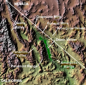
The Panamint Valley is a long basin located east of the Argus and Slate ranges, and west of the Panamint Range in the northeastern reach of the Mojave Desert, in eastern California, United States. Geography The northern end of the valley is in Death Valley National Park and Inyo County, California. The valley lies in a north–south direction, and stretches from the Panamint Dunes in the north to the Naval Air Weapons Station China Lake in San Bernardino County in the south. The valley is approximately 65 miles (105 km) in length, and is more than 10 miles (16 km) wide in the Hall Canyon area. Features * The ghost town of Ballarat is located in the Panamint Valley about three miles east of Trona Road, near Happy Canyon. * The Panamint Springs Resort, on Highway 190 west of Panamint Valley Road near Rainbow Canyon, provides the only lodging, dining, and gas in the area. *The former Epsom Salts Monorail crossed the valley on a wooden trestle. * A radar station is l ... [...More Info...] [...Related Items...] OR: [Wikipedia] [Google] [Baidu] |
Barker Ranch
Barker Ranch is located inside Death Valley National Park in eastern California. Used as a mining and recreational property from the 1940s to the 1960s, it is infamous due to its association with Charles Manson and his "family". It was the family's ''de facto'' headquarters. Early history Barker Ranch is located in a rock- and boulder-filled valley in the Panamint Range. It is accessible only by sandy, primitive and rugged roads. Streams feed this little valley and provide much vegetation. There is a small one-room guest house located to the side of the main house. There is also a five-thousand-gallon "swimming pool" (in reality a reservoir to store water from the spring) made from cement and rock boulders towards the back of the property. Bluch and Helen Thomason began construction of Barker Ranch around 1940. It was originally used as a storage and shop facility to support their mining activity in the area. They constructed a small cabin and out building, with electricity pro ... [...More Info...] [...Related Items...] OR: [Wikipedia] [Google] [Baidu] |
Special Use Airspace
Special use airspace (SUA) is an area designated for operations of a nature such that limitations may be imposed on aircraft not participating in those operations. Often these operations are of a military nature. The designation of SUAs identifies for other users the areas where such activity occurs, provides for segregation of that activity from other users, and allows charting to keep airspace users informed of potential hazards. Most SUAs are depicted on aeronautical charts and FAA maintains a page showing the current status of most SUAs. Special use airspace includes: restricted airspace, prohibited airspace, military operations areas (MOA), warning areas, alert areas, temporary flight restriction (TFR), national security areas, and controlled firing areas, typically up to FL180 or 18,000 ft above sea level. In addition there is often an Air Traffic Control Assigned Airspace (ATCAA) from FL180 through FL600 in which ATC plans for military operations. ATCAAs are genera ... [...More Info...] [...Related Items...] OR: [Wikipedia] [Google] [Baidu] |
Flight Level
In aviation and aviation meteorology, a flight level (FL) is an aircraft's altitude at standard air pressure, expressed in hundreds of feet. The air pressure is computed assuming an International Standard Atmosphere pressure of 1013.25 hPa (29.92 inHg) at sea level, and therefore is not necessarily the same as the aircraft's actual altitude, either above sea level or above ground level. Background Flight levels are used to ensure safe vertical separation between aircraft, despite natural local variations in atmospheric air pressure. Historically, altitude has been measured using a pressure altimeter, which is essentially a calibrated barometer. An altimeter measures ambient air pressure, which decreases with increasing altitude following the barometric formula. It then calculates and displays the corresponding altitude. If different aircraft's altimeters were not calibrated consistently, then two aircraft could be flying at the same altitude even though their altimeter ... [...More Info...] [...Related Items...] OR: [Wikipedia] [Google] [Baidu] |
R-2508 Special Use Airspace Complex
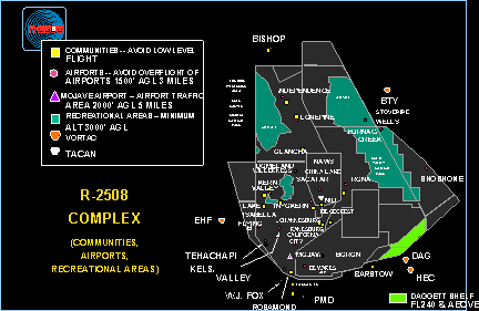
Edwards Air Force Base (AFB) is a United States Air Force installation in California. Most of the base sits in Kern County, but its eastern end is in San Bernardino County and a southern arm is in Los Angeles County. The hub of the base is Edwards, California. The base was named after World War II USAAF veteran and test pilot Capt. Glen Edwards in 1950; prior to then the facility was named Muroc Air Force Base. It is the home of the Air Force Test Center, Air Force Test Pilot School, and NASA's Armstrong Flight Research Center. It is the Air Force Materiel Command center for conducting and supporting research and development of flight, as well as testing and evaluating aerospace systems from concept to combat. It also hosts many test activities conducted by America's commercial aerospace industry. Notable occurrences at Edwards include Chuck Yeager's flight that broke the sound barrier in the Bell X-1, test flights of the North American X-15, the first landings of the Spac ... [...More Info...] [...Related Items...] OR: [Wikipedia] [Google] [Baidu] |
01-2007-PanamintValley
Increment or incremental may refer to: *Incrementalism, a theory (also used in politics as a synonym for gradualism) *Increment and decrement operators, the operators ++ and -- in computer programming *Incremental computing *Incremental backup, which contain only that portion that has changed since the preceding backup copy. *Increment, chess term for additional time a chess player receives on each move *Incremental games * Increment in rounding See also * * *1+1 (other) 1+1 is a mathematical expression that evaluates to: * 2 (number) (in ordinary arithmetic) * 1 (number) (in Boolean algebra with a notation where '+' denotes a logical disjunction) * 0 (number) (in Boolean algebra with a notation where '+' denotes ' ... {{Disambiguation da:Inkrementel fr:Incrémentation nl:Increment ja:インクリメント pl:Inkrementacja ru:Инкремент sr:Инкремент sv:++ ... [...More Info...] [...Related Items...] OR: [Wikipedia] [Google] [Baidu] |
Death Valley
Death Valley is a desert valley in Eastern California, in the northern Mojave Desert, bordering the Great Basin Desert. During summer, it is the Highest temperature recorded on Earth, hottest place on Earth. Death Valley's Badwater Basin is the point of lowest elevation in North America, at below sea level. It is east-southeast of Mount Whitney — the highest point in the contiguous United States, with an elevation of 14,505 feet (4,421 m). On the afternoon of July10, 1913, the National Weather Service, United States Weather Bureau recorded a high temperature of 134 °F (56.7 °C) at Furnace Creek, California, Furnace Creek in Death Valley, which stands as the Highest temperature recorded on Earth, highest ambient air temperature ever recorded on the surface of the Earth. This reading, however, and several others taken in that period are disputed by some modern experts. Lying mostly in Inyo County, California, near the border of California and Nevada, in the Great ... [...More Info...] [...Related Items...] OR: [Wikipedia] [Google] [Baidu] |
Lake Manly
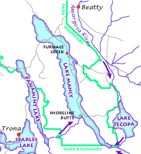
Lake Manly was a pluvial lake in Death Valley, California, covering much of Death Valley with a surface area of during the so-called "Blackwelder stand". Water levels varied through its history, and the chronology is further complicated by active tectonic processes that have modified the elevations of the various shorelines of Lake Manly; during the Blackwelder stage they reached above sea level. The lake received water mainly from the Amargosa River and at various points from the Mojave River and Owens River. The lake and its substantial catchment favoured the spread of a number of aquatic species, including some lizards, pupfish and springsnails. The lake probably supported a substantial ecosystem, and a number of diatoms developed there. In Death Valley, lakes existed during different times in the geological past. After some poorly defined lake stages during the Miocene, Pliocene and early Pleistocene, the first large lake stage occurred about 185,000–128,000 years ago ... [...More Info...] [...Related Items...] OR: [Wikipedia] [Google] [Baidu] |
Lake Panamint
Lake Panamint (also known as Lake Gale) is a former lake that occupied Panamint Valley in California during the Pleistocene. It was formed mainly by water overflowing through the Owens River and which passed through Lake Searles into the Panamint Valley. At times, Lake Panamint itself overflowed into Death Valley and Lake Manly. Geography and geomorphology The lake developed within Panamint Valley, California. This valley is a north–south trending depression that is bound between the Panamint Range in the northeast and the Argus Range- Slate Range in the west-southwest. The town of Ballarat lies in the valley, and California State Route 190 crosses the former lake basin in its northern sector. The existence of a lake in this valley was first postulated in 1914. Lake Panamint was about long and wide, making it a long and narrow lake. Both the main inlet and the potential outlet were located in a narrower southern part. The total water volume was about . The lake consisted o ... [...More Info...] [...Related Items...] OR: [Wikipedia] [Google] [Baidu] |
Pleistocene
The Pleistocene ( , often referred to as the ''Ice age'') is the geological Epoch (geology), epoch that lasted from about 2,580,000 to 11,700 years ago, spanning the Earth's most recent period of repeated glaciations. Before a change was finally confirmed in 2009 by the International Union of Geological Sciences, the cutoff of the Pleistocene and the preceding Pliocene was regarded as being 1.806 million years Before Present (BP). Publications from earlier years may use either definition of the period. The end of the Pleistocene corresponds with the end of the last glacial period and also with the end of the Paleolithic age used in archaeology. The name is a combination of Ancient Greek grc, label=none, πλεῖστος, pleīstos, most and grc, label=none, καινός, kainós (latinized as ), 'new'. At the end of the preceding Pliocene, the previously isolated North and South American continents were joined by the Isthmus of Panama, causing Great American Interchang ... [...More Info...] [...Related Items...] OR: [Wikipedia] [Google] [Baidu] |
Pluvial Lake
A pluvial lake is a body of water that accumulated in a basin because of a greater moisture availability resulting from changes in temperature and/or precipitation. These intervals of greater moisture availability are not always contemporaneous with glacial periods. Pluvial lakes are typically closed lakes that occupied endorheic basins. Pluvial lakes that have since evaporated and dried out may also be referred to as ''paleolakes''.Goudie, A.S., 2013. ''and semi-arid geomorphology.'' Cambridge University Press. Etymology The word comes from the Latin ''pluvia'', which means "rain". Geology Pluvial lakes represent changes in the hydrological cycle: wet cycles generate large lakes, and dry cycles cause the lakes to recede. Accumulated sediments show the variation in water level. During glacial periods, when the lake level is fairly high, mud sediments will settle out and be deposited. At times in between glaciers (interglacial), salt deposits may be present because of the ari ... [...More Info...] [...Related Items...] OR: [Wikipedia] [Google] [Baidu] |
Ephemeral
Ephemerality (from the Greek word , meaning 'lasting only one day') is the concept of things being transitory, existing only briefly. Academically, the term ephemeral constitutionally describes a diverse assortment of things and experiences, from digital media to types of streams. "There is no single definition of ephemerality". With respect to unique performances, for example, it has been noted that " hemerality is a quality caused by the ebb and flow of the crowd's concentration on the performance and a reflection of the nostalgic character of specific performances". Because different people may value the passage of time differently, ephemerality may be a relative, perceptual concept: "In brief, what is short-lived may not be the object itself, but the attention we afford it".Ronald Beiner, ''Political Philosophy: What It Is and Why It Matters'' (2014), p. 10. Ephemerality and nature Geographical features An ephemeral stream is that which only exists following precipitation. ... [...More Info...] [...Related Items...] OR: [Wikipedia] [Google] [Baidu] |


