|
Putiki
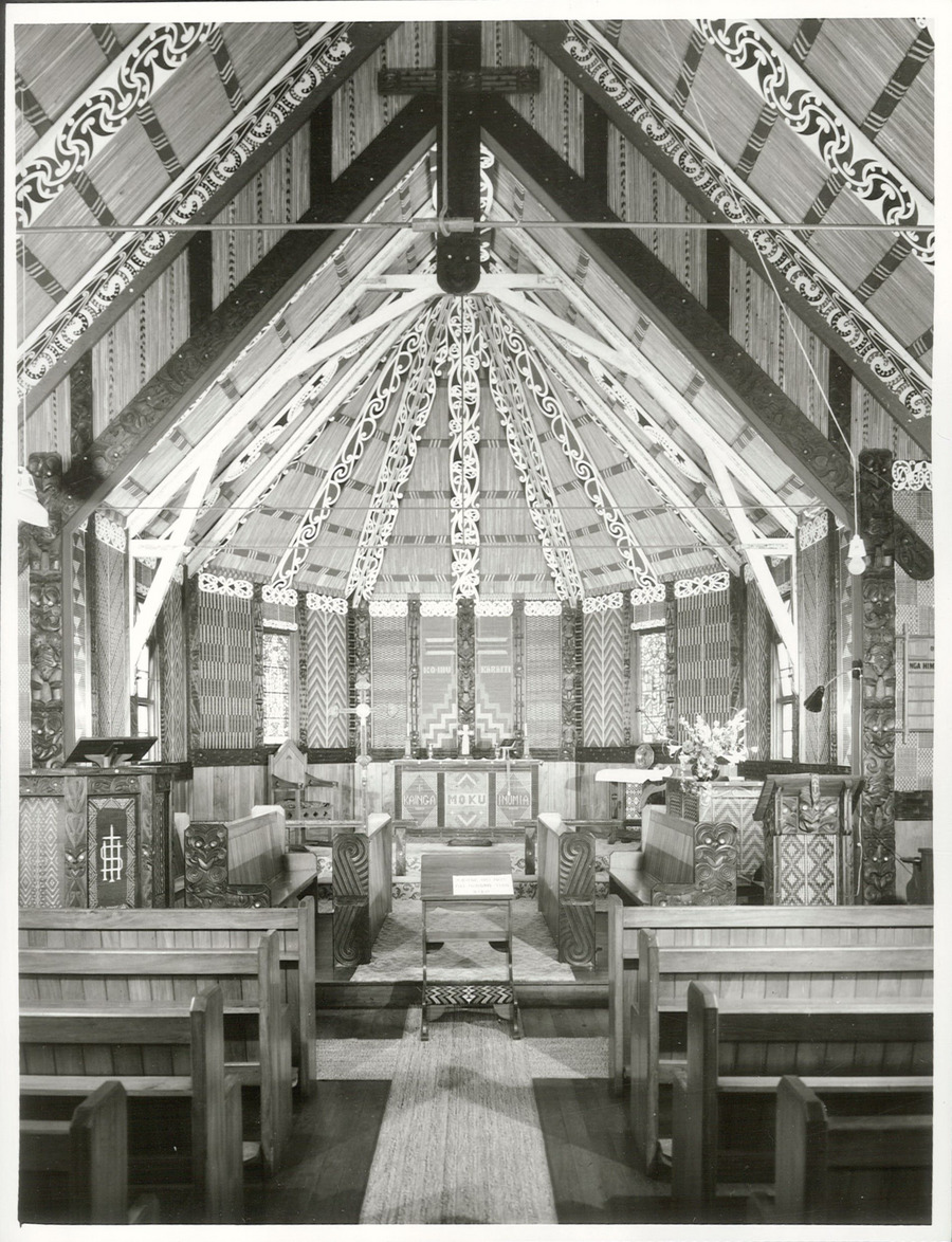
Putiki is a settlement in the Whanganui District and ManawatŇę-Whanganui region of New Zealand's North Island, located across the Whanganui River from Whanganui city. It includes the intersection of State Highway 3 and State Highway 4. The settlement was established around PŇętiki PńĀ, a tribal meeting ground of NgńĀti Tumango and NgńĀti Tupoho. It features Te Paku o Te Rangi meeting house, also known as Aotea meeting house. History 19th century PŇętiki PńĀ, recorded variously as Putiki Wharanui, Putiki Wharenui, Putiki Warenui, or by its full name Putiki-wharanui-a-Tamatea-pokai-whenua, as a well established pńĀ well before European arrival. The settlement was attacked by NgńĀti Toa in a bloody two-month siege in 1828 or 1829. About 400 locals were killed in the encounter. PŇętiki was the main MńĀori settlement at the Whanganui River mouth when Europeans began settling on the river in the 1840s. MńĀori from PŇętiki signed a deed of purchase with Edward Gibbon Wakefiel ... [...More Info...] [...Related Items...] OR: [Wikipedia] [Google] [Baidu] |
Whanganui
Whanganui (; ), also spelled Wanganui, is a city in the ManawatŇę-Whanganui region of New Zealand. The city is located on the west coast of the North Island at the mouth of the Whanganui River, New Zealand's longest navigable waterway. Whanganui is the 19th most-populous urban area in New Zealand and the second-most-populous in ManawatŇę-Whanganui, with a population of as of . Whanganui is the ancestral home of Te ńÄti Haunui-a-PńĀpńĀrangi and other Whanganui MńĀori tribes. The New Zealand Company began to settle the area in 1840, establishing its second settlement after Wellington. In the early years most European settlers came via Wellington. Whanganui greatly expanded in the 1870s, and freezing works, woollen mills, phosphate works and wool stores were established in the town. Today, much of Whanganui's economy relates directly to the fertile and prosperous farming hinterland. Like several New Zealand urban areas, it was officially designated a city until an administrativ ... [...More Info...] [...Related Items...] OR: [Wikipedia] [Google] [Baidu] |
New Zealand State Highway 3
State Highway 3 (SH 3) is one of New Zealand's eight national state highways. It serves the west coast of the country's North Island and forms a link between State Highway 1 and State Highway 2. Distances are measured from north to south. For most of its length SH 3 is a two-lane single carriageway, with at-grade intersections and property accesses, both in rural and urban areas. History A Mokau ‚Äď Awakino horse track was widened to a dray track about 1897. It was then possible for a horse and buggy to cover the ‚Äď now 162 km ‚Äď from New Plymouth to Te Kuiti in 17¬Ĺ hours. The first car to traverse the route from Auckland to New Plymouth seems to have been an 8 hp Cadillac in 1905, though Otorohanga to Te Kuiti was by train and, between Awakino and Mokau, a horse assisted on the beach. A 1910 Te Kuiti meeting called for metalling of the road to Awakino. Mount Messenger Tunnel opened in 1916 and its single lane was enlarged about 1983. ¬£3,000 (2016 equi ... [...More Info...] [...Related Items...] OR: [Wikipedia] [Google] [Baidu] |
Richard Taylor (missionary)
Richard Taylor (21 March 1805 ‚Äď 10 October 1873) was a Church Missionary Society (CMS) missionary in New Zealand. He was born on 21 March 1805 at Letwell, Yorkshire, England, one of four children of Richard Taylor and his wife, Catherine Spencer. He attended Queens' College, Cambridge and after graduating BA in 1828, he was ordained as a priest on 8 November 1829. In 1835, he was conferred MA and appointed a missionary in New Zealand for the CMS. Church Missionary Society He was present at the signing of the Treaty of Waitangi on 6 February 1840. In 1840 he was appointed as head of the school at Te Waimate mission, then in 1842 posted to the CMS mission station at Whanganui. By 1844 the brick church built by the Revd John Mason was inadequate to meet the needs of the congregation and it had been damaged in an earthquake. A new church was built under the supervision of the Revd Richard Taylor with the timber supplied by each pńĀ on the river in proportion to its size ... [...More Info...] [...Related Items...] OR: [Wikipedia] [Google] [Baidu] |
Hoani Wiremu Hńępango
Hoani Wiremu Hńępango ( 1820 ‚Äď 25 February 1865) was a MńĀori tribal leader, teacher and assessor of the Whanganui River area of New Zealand. He was a leader of NgńĀti Tumango, of the Te ńÄti Haunui-a-PńĀpńĀrangi iwi. He converted to Christianity and was baptised at Putiki, near present-day Whanganui, in 1841. He visited England with missionary Richard Taylor in 1855. He opposed the Pai MńĀrire (Hauhau) movement in the 1860s and led anti-Hauhau forces in battle. In February 1865 he led an attack on a Hauhau pńĀ near Pipiriki Pipiriki is a settlement in New Zealand, on the east bank of the Whanganui River, due west of the town of Raetihi and upriver from Whanganui; it was originally on the opposite bank. It is the home of NgńĀti Kura, a hapŇę of the NgńĀti Ruanui iwi .... They captured the pńĀ, but Hńępango was seriously injured and died of his wounds two days later, on 25 February, at the age of about 45. He was buried at Korokata hill, overlooking PŇętiki. References ... [...More Info...] [...Related Items...] OR: [Wikipedia] [Google] [Baidu] |
New Zealand State Highway 4
State Highway 4 is the shortest of New Zealand's eight national highways. It runs north-south across rugged hill country, forming a short cut between two points on State Highway 3 thereby avoiding Taranaki and the coasts of the North and South Taranaki Bights. Distances are measured from north to south. For most of its length SH4 is a two-lane single carriageway, with at-grade intersections and property accesses, both in rural and urban areas. The NZ Transport Agency (NZTA) classifies SH 4 as a primary collector road, except between National Park (SH 47) and Tohunga Junction (SH 49) where it is classified an arterial road. Route The highway commences from a junction on SH 3 11 km south of Te Kuiti. It heads south-southeast, climbing initially, then descending along the winding valleys of the ŇĆhura and Ongarue Rivers, two tributaries of the Whanganui. The Ongarue joins the Whanganui close to Taumarunui, and here the highway turns east briefly, ascending ... [...More Info...] [...Related Items...] OR: [Wikipedia] [Google] [Baidu] |
Durie Hill
Durie Hill is a suburb of Whanganui, in the Whanganui District and ManawatŇę-Whanganui region of New Zealand's North Island. The suburb was designed in 1920 by Samuel Hurst Seager as a garden suburb based on garden-city planning principles. It was designed with curvilinear streets, reserves, croquet lawns and tennis courts. The Durie Hill Elevator connects the suburb with Anzac Parade. The elevator and tunnel were proposed by Wanganui Chronicle editor John Ball and Technical School engineering instructor Edward Crow, but most residents of the new suburb refused to fund it. A revitalisation programme was launched in 2019, including the introduction of planter boxes and the founding of a village market. Demographics The statistical area of Bastia-Durie Hill, which covers , had a population of 2,130 at the 2018 New Zealand census, an increase of 18 people (0.9%) since the 2013 census, and a decrease of 9 people (-0.4%) since the 2006 census 6 (six) is the natural number follo ... [...More Info...] [...Related Items...] OR: [Wikipedia] [Google] [Baidu] |
Mete Kńęngi Paetahi
Mete Kńęngi Te Rangi Paetahi (c. 1813 ‚Äď 22 September 1883) was a Member of Parliament in New Zealand. He was one of four MńĀori elected in the first MńĀori elections of 1868 for the new MńĀori electorates in the House of Representatives. Private life Mete Kńęngi was the chief of the NgńĀti Poutama (or NgńĀ Poutama) and NgńĀti TŇęmango hapu of Te ńÄti Haunui-a-PńĀpńĀrangi in the Whanganui River area. His father was Paetahi and his mother Utaora. He opposed the Pai MńĀrire (Hauhau) movement in the 1860s and fought against the Hauhau, becoming known popularly as 'General Mete Kńęngi'. When HŇćri Kńęngi Te ńÄnaua died in September 1868, Mete Kńęngi succeeded him as the highest-ranking chief in the tribes of the lower Wanganui. Political career Mete Kńęngi was the only candidate proposed at the nomination meeting for Western Maori, one of the new MńĀori electorates, at the Wanganui Whanganui (; ), also spelled Wanganui, is a city in the ManawatŇę-Whanganui region of N ... [...More Info...] [...Related Items...] OR: [Wikipedia] [Google] [Baidu] |
Whanganui Central
Whanganui Central is the central business district and central suburb of Whanganui, in the Whanganui District and ManawatŇę-Whanganui region of New Zealand's North Island. Demographics Whanganui Central, comprising the statistical areas of Laird Park, Cornmarket and Whanganui Central, covers . It had a population of 4,203 at the 2018 New Zealand census, an increase of 417 people (11.0%) since the 2013 census, and an increase of 72 people (1.7%) since the 2006 census. There were 1,878 households. There were 1,980 males and 2,220 females, giving a sex ratio of 0.89 males per female, with 705 people (16.8%) aged under 15 years, 843 (20.1%) aged 15 to 29, 1,803 (42.9%) aged 30 to 64, and 855 (20.3%) aged 65 or older. Ethnicities were 72.1% European/PńĀkehńĀ, 28.6% MńĀori, 5.1% Pacific peoples, 7.3% Asian, and 2.1% other ethnicities (totals add to more than 100% since people could identify with multiple ethnicities). The proportion of people born overseas was 15.8%, compared with ... [...More Info...] [...Related Items...] OR: [Wikipedia] [Google] [Baidu] |
Gonville, New Zealand
Gonville is a residential suburb of Whanganui, New Zealand. It is under the local governance of the Whanganui District Council. Pakaitore Marae and meeting house is located in Gonville. It is the tribal meeting ground of the NgńĀti HńĀua (subtribe) of NgńĀti HńĀua. Demographics Gonville, comprising the statistical areas of Gonville West, Gonville North and Gonville South, covers . It had a population of 6,276 at the 2018 New Zealand census, an increase of 342 people (5.8%) since the 2013 census, and an increase of 123 people (2.0%) since the 2006 census. There were 2,478 households. There were 3,063 males and 3,204 females, giving a sex ratio of 0.96 males per female, with 1,416 people (22.6%) aged under 15 years, 1,254 (20.0%) aged 15 to 29, 2,622 (41.8%) aged 30 to 64, and 981 (15.6%) aged 65 or older. Ethnicities were 74.0% European/PńĀkehńĀ, 32.5% MńĀori, 5.6% Pacific peoples, 4.4% Asian, and 1.6% other ethnicities (totals add to more than 100% since people could identif ... [...More Info...] [...Related Items...] OR: [Wikipedia] [Google] [Baidu] |
George Grey
Sir George Grey, KCB (14 April 1812 ‚Äď 19 September 1898) was a British soldier, explorer, colonial administrator and writer. He served in a succession of governing positions: Governor of South Australia, twice Governor of New Zealand, Governor of Cape Colony, and the 11th premier of New Zealand. He played a key role in the colonisation of New Zealand, and both the purchase and annexation Annexation (Latin ''ad'', to, and ''nexus'', joining), in international law, is the forcible acquisition of one state's territory by another state, usually following military occupation of the territory. It is generally held to be an illegal act ... of MńĀori land. Grey was born in Lisbon, Portugal, just a few days after his father, Lieutenant-Colonel George Grey was killed at the Siege of Badajoz (1812), Battle of Badajoz in Spain. He was educated in England. After military service (1829‚Äď37) and two explorations in Western Australia (1837‚Äď39), Grey became Governor of History o ... [...More Info...] [...Related Items...] OR: [Wikipedia] [Google] [Baidu] |
Moutoa Island
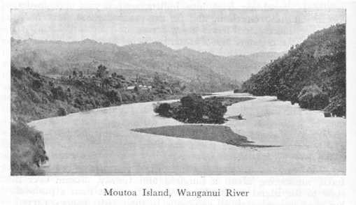
Moutoa Island is an island of shingle approximately long, up the Whanganui River, New Zealand between the towns of RńĀnana and Hiruharama. Surrounded by rapids, it has been the site of many battles, the most famous being on 14 May 1864, between a force of Pai MńĀrire followers from the upper Whanganui and NgńĀti Hau from the lower Whanganui, during the Second Taranaki War. A statue unveiled in 1865 in Moutoa Gardens in Whanganui Whanganui (; ), also spelled Wanganui, is a city in the ManawatŇę-Whanganui region of New Zealand. The city is located on the west coast of the North Island at the mouth of the Whanganui River, New Zealand's longest navigable waterway. Whangan ... commemorates the battle. References Whanganui River Landforms of ManawatŇę-Whanganui River islands of New Zealand {{ManawatuWanganui-geo-stub ... [...More Info...] [...Related Items...] OR: [Wikipedia] [Google] [Baidu] |
Edward Gibbon Wakefield
Edward Gibbon Wakefield (20 March 179616 May 1862) is considered a key figure in the establishment of the colonies of South Australia and New Zealand (where he later served as a member of parliament). He also had significant interests in British North America, being involved in the drafting of Lord Durham's Report and being a member of the Parliament of the Province of Canada for a short time. He was best known for his colonisation scheme, sometimes referred to as the Wakefield scheme, which aimed to populate the new colony South Australia with a workable combination of labourers, tradespeople, artisans and capital. The scheme was to be financed by the sale of land to the capitalists who would thereby support the other classes of emigrants. Despite being imprisoned for three years in 1827 for kidnapping a fifteen-year-old girl in Britain, he enjoyed a distinguished political career. Early life Wakefield was born in London in 1796, the eldest son of Edward Wakefield (1774‚Ä ... [...More Info...] [...Related Items...] OR: [Wikipedia] [Google] [Baidu] |

.jpg)


