|
Puka-Puka
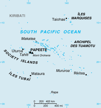
Puka-Puka is a small coral atoll in the north-eastern Tuamotu Archipelago, sometimes included as a member of the Disappointment Islands. This atoll is quite isolated, the nearest land being Fakahina, 182 km to the southwest. Puka-Puka Atoll has an elliptical shape. Its length is 6 km and its maximum width 3.3 km. Its land area is about 5 km2. The lagoon is filled with silt and has become very small. The low coral islands are dry and sparsely populated. According to the 2017 census, the total population was 163.Répartition de la population en Polynésie française en 2017 Institut de la statistique de la Polynésie française The chief town is Te One Mahina, with about 110 inhabitants. Unlike the rest of the Tuamotus, the languag ... [...More Info...] [...Related Items...] OR: [Wikipedia] [Google] [Baidu] |
Puka-Puka Atoll (ISS004-E-8846)
Puka-Puka is a small coral atoll in the north-eastern Tuamotus, Tuamotu Archipelago, sometimes included as a member of the Disappointment Islands. This atoll is quite isolated, the nearest land being Fakahina, 182 km to the southwest. Puka-Puka Atoll has an elliptical shape. Its length is 6 km and its maximum width 3.3 km. Its land area is about 5 km2. The lagoon is filled with silt and has become very small. The low coral islands are dry and sparsely populated. According to the 2017 census, the total population was 163.Répartition de la population en Polynésie française en 2017 Institut de la statistique de la Polynésie française The chief town is Te One Mahina, with about 110 inhabitants. Unlike the rest of the Tuamotus, t ... [...More Info...] [...Related Items...] OR: [Wikipedia] [Google] [Baidu] |
Disappointment Islands
The Disappointment Islands (french: Îles du Désappointement) are a subgroup of the Tuamotu Archipelago in French Polynesia. They are located towards the northeast, away from the main Tuamotu group. The Disappointment Islands are a small group of coral islands, which includes the island of Tepoto and the atoll of Napuka. Puka-Puka, to their southeast, is often included in this subgroup. These islands are arid, and are not especially conducive to human habitation. Demographics The Disappointment Islands are sparsely populated. The inhabitants are overwhelmingly native Polynesians. According to the 2002 census, the population of the islands is as follows: * Tepoto: 54 * Napuka: 257 * Puka-Puka: 197 Administration Administratively Tepoto Island belongs to the commune of Napuka, while Puka-Puka has its own commune. History The western Disappointment Islands, Tepoto and Napuka, were colonized by voyagers from the neighboring Tuamotus, but Puka-Puka was colonized by se ... [...More Info...] [...Related Items...] OR: [Wikipedia] [Google] [Baidu] |
Puka-Puka Airport
Puka-Puka Airport is an airport on Puka-Puka in French Polynesia . The airport is 3 km northeast of the village of Teonemahina. The airport is extremely vulnerable to climate change caused sea level rise. The airport only sits 1.5 meters in elevation above sea level Mean sea level (MSL, often shortened to sea level) is an average surface level of one or more among Earth's coastal bodies of water from which heights such as elevation may be measured. The global MSL is a type of vertical datuma standardised g ..., so even with low end climate model predictions, the airport is likely to be flooded. Airlines and destinations Passenger Statistics References External links * Airports in French Polynesia {{FrenchPolynesia-geo-stub ... [...More Info...] [...Related Items...] OR: [Wikipedia] [Google] [Baidu] |
Marquesan Language
Marquesan is a collection of East-Central Polynesian dialects, of the Marquesic group, spoken in the Marquesas Islands of French Polynesia. They are usually classified into two groups, North Marquesan and South Marquesan, roughly along geographic lines.See Charpentier & François (2015). Phonology The most striking feature of the Marquesan languages is their almost universal replacement of the or of other Polynesian languages by a (glottal stop). Like other Polynesian languages, the phonology of Marquesan languages is characterized by a scarcity of consonants and a comparative abundance of vowels. The consonant phonemes are: Of this small number of consonants, is found only in eastern Nuku Hiva (Tai Pi Marquesan), and is found only in South Marquesan dialects. In writing, the phoneme is written , and is written , the okina. Unlike Samoan, the is not an isolated nasal: it is found only in conjunction with a following . So, whereas the Samoan word for 'bay' is , pr ... [...More Info...] [...Related Items...] OR: [Wikipedia] [Google] [Baidu] |
Tuamotus
The Tuamotu Archipelago or the Tuamotu Islands (french: Îles Tuamotu, officially ) are a French Polynesian chain of just under 80 islands and atolls in the southern Pacific Ocean. They constitute the largest chain of atolls in the world, extending (from northwest to southeast) over an area roughly the size of Western Europe. Their combined land area is . This archipelago's major islands are Anaa, Fakarava, Hao and Makemo. The Tuamotus have approximately 16,000 inhabitants. The islands were initially settled by Polynesians, and modern Tuamotuans have inherited from them a shared Polynesian culture, culture and the Tuamotuan language. The Tuamotus are a overseas collectivity, French overseas collectivity. History The early history of the Tuamotu islands is generally unknown. Archaeological findings suggest that the western Tuamotus were settled from the Society Islands as early as 900 CE or as late as 1200 CE. DNA evidence suggests that they were settled about 1110 CE. On the ... [...More Info...] [...Related Items...] OR: [Wikipedia] [Google] [Baidu] |
Flint Island
Flint Island is an uninhabited coral island in the central Pacific Ocean, part of the Southern Line Islands under the jurisdiction of Kiribati. In 2014 the Kiribati government established a exclusion zone around each of the southern Line Islands (Caroline (commonly called Millennium), Flint, Vostok, Malden, and Starbuck). Geography Flint Island is located about northwest of Tahiti, south-southeast of Vostok Island, and southwest of Caroline Island. The island is about long and wide at its widest point (). It has a land area of and rises to a height of above sea level. The island is surrounded by a narrow fringing reef and with no safe anchorage, landing is difficult. According to the U.S. Exploring Expedition (February 5, 1841), the island was thickly wooded with primeval forest, however the island is now mostly covered with planted coconut palms. History Flint island was discovered by the Spanish expedition of Ferdinand Magellan on 4 February 1521, and charted as ... [...More Info...] [...Related Items...] OR: [Wikipedia] [Google] [Baidu] |
Kon Tiki
The ''Kon-Tiki'' expedition was a 1947 journey by raft across the Pacific Ocean from South America to the Polynesian islands, led by Norwegian explorer and writer Thor Heyerdahl. The raft was named ''Kon-Tiki'' after the Inca god Viracocha, for whom "Kon-Tiki" was said to be an old name. ''Kon-Tiki'' is also the name of Heyerdahl's book, the Academy Award–winning 1950 documentary film chronicling his adventures, and the 2012 dramatized feature film nominated for the Academy Award for Best Foreign Language Film. Heyerdahl believed that people from South America could have reached Polynesia during pre-Columbian times. His aim in mounting the ''Kon-Tiki'' expedition was to show, by using only the materials and technologies available to those people at the time, that there were no technical reasons to prevent them from having done so. Although the expedition carried some modern equipment, such as a radio, watches, charts, sextant, and metal knives, Heyerdahl argued they were inc ... [...More Info...] [...Related Items...] OR: [Wikipedia] [Google] [Baidu] |
Fakahina
Fakahina, or Kaīna, is a small atoll in the north of the Tuamotu group in French Polynesia. The nearest land is Fangatau Atoll, located 72 km to the north-west. Fakahina's length is and its maximum width . It has a land area of and a lagoon area of . There is no pass connecting the lagoon with the ocean. Fakahina has 155 inhabitants. The main village is Tarione. History The first recorded European to arrive to Fakahina Atoll was Otto von Kotzebue, sailing in the service of the Russian tsars, in 1824. This atoll appears as "Predpriati" in some maps. At the beginning of the 20th century part of the population of Fakahina was moved to Puka-Puka to work in the production of copra. Administration Fakahina belongs to the commune A commune is an alternative term for an intentional community. Commune or comună or comune or other derivations may also refer to: Administrative-territorial entities * Commune (administrative division), a municipality or township ** Communes of ... [...More Info...] [...Related Items...] OR: [Wikipedia] [Google] [Baidu] |
List Of Reduplicated Place Names
This is a list of places with reduplication in their names, often as a result of the grammatical rules of the languages from which the names are derived. Duplicated names from the indigenous languages of Australia, Chile and New Zealand are listed separately and excluded from this page. Place names * Alangalang, Leyte, Philippines * Alang-alang, Mandaue, Philippines * Arar, Saudi Arabia * Baden-Baden, Germany * Banaybanay, Davao Oriental, Philippines * Banay-Banay, Cabuyao, Philippines * Barbar, Bahrain * Baubau, Indonesia * Bela-Bela, Limpopo Province, South Africa * Bella Bella, British Columbia, Canada * Benabena, Papua New Guinea * Berber, Sudan * Bidbid, Oman * Blup Blup, Papua New Guinea * Bongbong, Philippines * Bora Bora, French Polynesia * Botbot, Pandan, Philippines * Bud Bud, West Bengal, India * Budge Budge, West Bengal, India * Bulbul, Syria * Bulo Bulo, Bolivia * Carcar, Philippines * Cárcar, Spain * Cascas, Peru * Cece, Hungary * Chak Chak, Y ... [...More Info...] [...Related Items...] OR: [Wikipedia] [Google] [Baidu] |
Îles Tuamotu-Gambier
The Îles Tuamotu-Gambier (french: Îles Tuamotu-Gambier or ''Archipels des Tuamotu et des Gambier'' or ''Archipel des Tuamotu-Gambier'' or ''Tuamotu-Gambier'' or officially ''subdivision administrative des (Îles) Tuamotu-Gambier'') is an administrative division in French Polynesia. It consists of the Tuamotus and the Gambier Islands which are geographically located closely together. Because of a difference between administrative districts and electoral circumscriptions on the Îles Tuamotu-Gambier, French Polynesia has 5 administrative subdivisions (french: subdivisions administratives), but 6 electoral districts/electoral circumscriptions (french: circonscriptions électorales). It has an area of 726.5 square kilometers and an estimated population of 16,881 people according to data from 2017. Administrative division Administratively, the Îles Tuamotu-Gambier form one of the 5 administrative subdivisions (''subdivision administratives'') of French Polynesia, the administrativ ... [...More Info...] [...Related Items...] OR: [Wikipedia] [Google] [Baidu] |
Willem Schouten
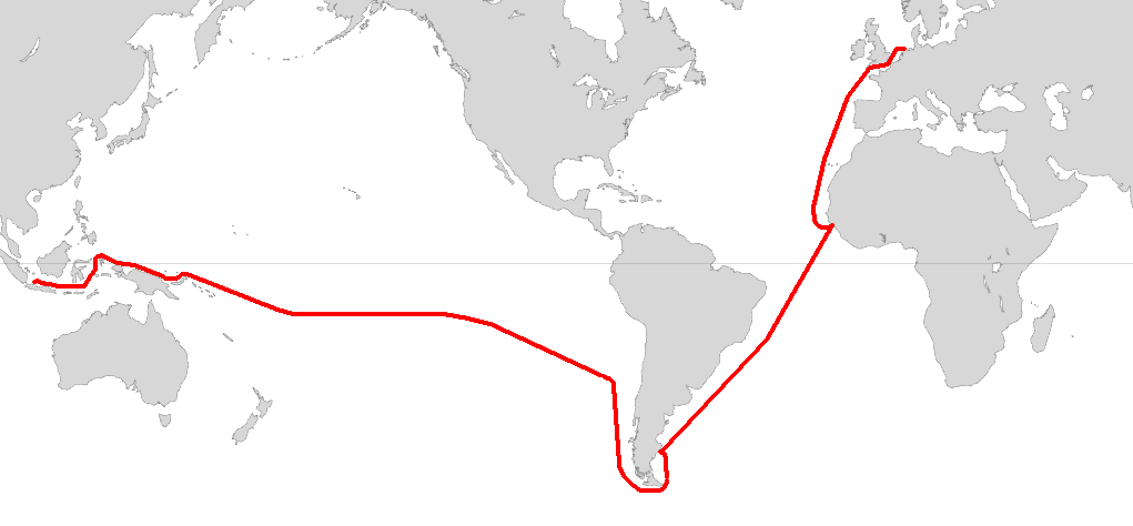
Willem Cornelisz Schouten ( – 1625) was a Dutch navigator for the Dutch East India Company. He was the first to sail the Cape Horn route to the Pacific Ocean. Biography Willem Cornelisz Schouten was born in c. 1567 in Hoorn, Holland, Seventeen Provinces. In 1615 Willem Cornelisz Schouten and his younger brother Jan Schouten sailed from Texel in the Netherlands, in an expedition led by Jacob Le Maire and sponsored by Isaac Le Maire and his ''Australische Compagnie'' in equal shares with Schouten. The expedition consisted of two ships: ''Eendracht'' and ''Hoorn''.Quanchi, ''Historical Dictionary of the Discovery and Exploration of the Pacific Islands'', pp. 222–33 A main purpose of the voyage was to search for ''Terra Australis''. A further objective was to explore a western route to the Pacific Ocean to evade the trade restrictions of the Dutch East India Company (VOC) in the Spice Islands. In 1616 Schouten rounded Cape Horn, which he named after the recently destroyed ... [...More Info...] [...Related Items...] OR: [Wikipedia] [Google] [Baidu] |
Légifrance
Légifrance is the official website of the French government for the publication of legislation, regulations, and legal information. Access to the site is free. Virtually complete, it presents or refers to all concerned institutions or administrations, all texts still in force since 1539 and all the upper courts jurisprudence since 1986 as well as the most pertinent one of all courts since 1875. C.E. 19 February 1875, Prince Napoléon, 46707. See also *References ''All texts in French unless otherwise noted.''[...More Info...] [...Related Items...] OR: [Wikipedia] [Google] [Baidu] |
.jpg)


.jpg)

