|
Puerto Chale
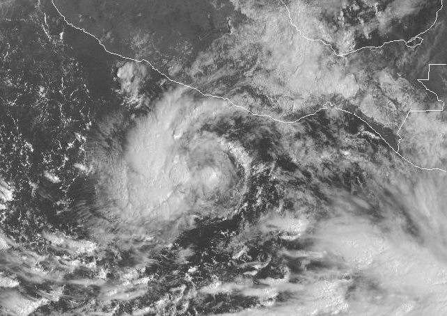
Puerto Chale is a town located on the Pacific coast side of La Paz Municipality, Baja California Sur, La Paz Municipality in the Mexico, Mexican state of Baja California Sur. Hurricane Norbert (2008), Hurricane Norbert made landfall in Puerto Chale on October 11, 2008, with 105 mph winds, a Category 2 hurricane. It had a population of 373 inhabitants in the 2010 census and is located at an elevation of 1 meter (3 ft.) above sea level. References 2010 census tables: INEGI Populated places in Baja California Sur {{BajaCaliforniaSur-geo-stub ... [...More Info...] [...Related Items...] OR: [Wikipedia] [Google] [Baidu] |
La Paz Municipality, Baja California Sur
La Paz is a municipality of the Mexican state of Baja California Sur. Its area of 20,275 km² (7,828.2 sq mi) makes it the municipality in Mexico with the fourth-largest area. , , SEGOB (Mexico.) Accessed on line 15-II-2008. It had a population of 290,286 inhabitants in the 2015 census. Its municipal seat, also named |
Mexico
Mexico (Spanish: México), officially the United Mexican States, is a country in the southern portion of North America. It is bordered to the north by the United States; to the south and west by the Pacific Ocean; to the southeast by Guatemala, Belize, and the Caribbean Sea; and to the east by the Gulf of Mexico. Mexico covers ,Mexico ''''. . making it the world's 13th-largest country by are ... [...More Info...] [...Related Items...] OR: [Wikipedia] [Google] [Baidu] |
Baja California Sur
Baja California Sur (; 'South Lower California'), officially the Free and Sovereign State of Baja California Sur ( es, Estado Libre y Soberano de Baja California Sur), is the least populated state and the 31st admitted state of the 32 federal entities which comprise the 31 States of Mexico. It is also the ninth-largest Mexican state in terms of area. Before becoming a state on 8 October 1974, the area was known as the ''El Territorio Sur de Baja California'' ("South Territory of Lower California"). It has an area of , or 3.57% of the land mass of Mexico, and occupies the southern half of the Baja California Peninsula, south of the 28th parallel, plus the uninhabited Rocas Alijos in the Pacific Ocean. It is bordered to the north by the state of Baja California, to the west by the Pacific Ocean, and to the east by the Gulf of California. The state has maritime borders with Sonora and Sinaloa to the east, across the Gulf of California. The state is home to the tourist resorts ... [...More Info...] [...Related Items...] OR: [Wikipedia] [Google] [Baidu] |
Hurricane Norbert (2008)
Hurricane Norbert is tied with Hurricane Jimena (2009), Hurricane Jimena as the strongest tropical cyclone to strike the west coast of Baja California Sur in recorded history. The fifteenth named storm, seventh hurricane, and second major hurricane of the 2008 Pacific hurricane season, 2008 hurricane season, Norbert originated as a tropical depression from a tropical wave south of Acapulco on October 3. Strong wind shear initially prevented much development, but the cyclone encountered a more favorable environment as it moved westward. On October 5, the National Hurricane Center (NHC) upgraded the depression to Tropical Storm Norbert, and the system intensified further to attain hurricane intensity by October 6. After undergoing a period of rapid deepening, Norbert reached its peak intensity as a Category 4 on the Saffir–Simpson hurricane wind scale, with maximum sustained winds of and a minimum atmospheric pressure, barometric pressure of . As the cyclone rou ... [...More Info...] [...Related Items...] OR: [Wikipedia] [Google] [Baidu] |
Hurricane
A tropical cyclone is a rapidly rotating storm system characterized by a low-pressure center, a closed low-level atmospheric circulation, strong winds, and a spiral arrangement of thunderstorms that produce heavy rain and squalls. Depending on its location and strength, a tropical cyclone is referred to by different names, including hurricane (), typhoon (), tropical storm, cyclonic storm, tropical depression, or simply cyclone. A hurricane is a strong tropical cyclone that occurs in the Atlantic Ocean or northeastern Pacific Ocean, and a typhoon occurs in the northwestern Pacific Ocean. In the Indian Ocean, South Pacific, or (rarely) South Atlantic, comparable storms are referred to simply as "tropical cyclones", and such storms in the Indian Ocean can also be called "severe cyclonic storms". "Tropical" refers to the geographical origin of these systems, which form almost exclusively over tropical seas. "Cyclone" refers to their winds moving in a circle, whirling round ... [...More Info...] [...Related Items...] OR: [Wikipedia] [Google] [Baidu] |

