|
Prešov Region
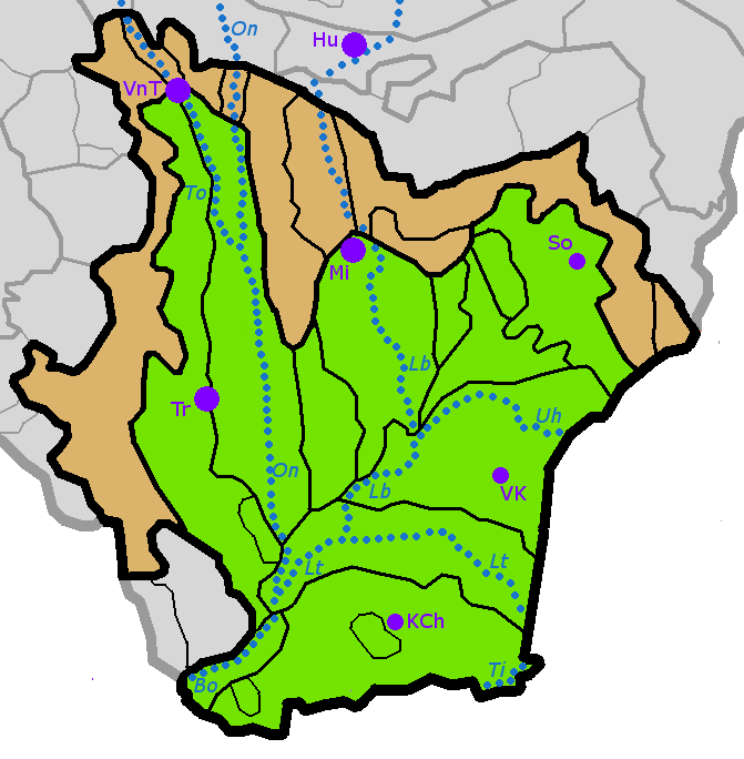
The Prešov Region, also Priashiv Region ( sk, Prešovský kraj, ; hu, Eperjesi kerület; uk, Пряшівський край) is one of the eight Slovak administrative regions and consists of 13 districts (okresy) and 666 municipalities, 23 of which have town status. The region was established in 1996 and is the most populous of all the regions in Slovakia. Its administrative center is the city of Prešov. Geography It is located in the north-eastern Slovakia and has an area of 8,975 km2. The region has a predominantly mountainous landscape. The subdivisions of Tatras – High Tatras and Belianske Tatras lie almost entirely in the region and include the highest point of Slovakia – Gerlachovský štít (2,654 ASL). Other mountain ranges and highlands in the region are Šarišská vrchovina, Čergov, Ondavská vrchovina, Slanské vrchy, Pieniny, Levoča Hills, Laborecká vrchovina, Bukovské vrchy, Vihorlat Mountains and Eastern Slovak Lowland. The basins in Prešov ... [...More Info...] [...Related Items...] OR: [Wikipedia] [Google] [Baidu] |
Regions Of Slovakia
Since 1949 (except 1990–1996), Slovakia has been divided into a number of ''kraje'' (singular ''kraj''; usually translated as "Regions" with capital R). Their number, borders and functions have been changed several times. There are eight regions of Slovakia and they correspond to the EU's NUTS 3 level of local administrative units. Each kraj consists of '' okresy'' (counties or districts). There are 79 districts. List After a period without kraje and without any equivalent (1990–1996), the kraje were reintroduced in 1996. As for administrative division, Slovakia has been subdivided into 8 ''kraje'' since 24 July 1996: Since 2002, Slovakia is divided into 8 ''samosprávne kraje'' (self-governing regions), which are called by the Constitution ''vyššie územné celky'' (Higher Territorial Units), abbr. VÚC. The territory and borders of the self-governing regions are identical with the territory and borders of the ''kraje''. Therefore, the word "kraj" can be replaced ... [...More Info...] [...Related Items...] OR: [Wikipedia] [Google] [Baidu] |
Levoča Hills
Levoča (; hu, Lőcse; rue, Левоча) is a town in the Prešov Region of eastern Slovakia with a population of 14,700. The town has a historic center with a well preserved town wall, a Gothic church with the highest wooden altar in the world, carved by Master Pavol of Levoča, and many other Renaissance buildings. On 28 June 2009, Levoča was added by UNESCO to its World Heritage List. Etymology The name is of Slovak origin and belongs to the oldest recorded Slovak settlement names in Spiš. It was originally the name of the stream Lěvoča, a tributary of river Hornád (present-day Levočský potok). The name probably derived from the adjective ''lěva'' (left, a left tributary); the linguist Rudolf Krajčovič has also suggested as an origin the word ''lěvoča'' meaning "regularly flooded area". History Levoča is located in the historical region of Spiš, which was inhabited as early as the Stone Age. In the 11th century, this region was conquered and, subsequently, ... [...More Info...] [...Related Items...] OR: [Wikipedia] [Google] [Baidu] |
Ondava
The Ondava is a river in eastern Slovakia, the northern source river of the Bodrog. Its source is in the Low Beskids (Eastern Carpathian Mountains), near the village Nižná Polianka, close to the border with Poland. The Ondava flows south through the towns Svidník, Stropkov and Trhovište, and through the Ondavská Highlands. It is long and its basin size is . Near the village Cejkov, the Ondava joins the Latorica and forms the Bodrog river, itself a tributary of the Tisza. The Ondava river is 44% regulated.Danube Facts and Figures – The Slovak Republic (March 2007)(.pdf) Retrieved October 30, 2007. Tributaries *Major left tributaries – Mirošovec, Ladomírka, Chotčianka, Brusnička, Oľka and Ondavka. *Major right tributary – Topľa Topľa ( hu, Tapoly, german: Töpl) is a river in eastern Slovakia and right tributary of the Ondava. It is long and its basin covers an area of . It rises in the Čergov mountains, flows through Ondava Highlands, Beskidian Pi ... [...More Info...] [...Related Items...] OR: [Wikipedia] [Google] [Baidu] |
Torysa (river)
The Torysa (, hu, Tarca) is a river in eastern Slovakia. Its source is in the Levoča Mountains and it flows through the towns of: Lipany, Sabinov, Veľký Šariš, Prešov, and into the Hornád river near Nižná Hutka, southeast of Košice Košice ( , ; german: Kaschau ; hu, Kassa ; pl, Коszyce) is the largest city in eastern Slovakia. It is situated on the river Hornád at the eastern reaches of the Slovak Ore Mountains, near the border with Hungary. With a population of app .... It is long and its basin size is . p. 43 References Rivers of Slovakia {{Slovakia-river-stub ...[...More Info...] [...Related Items...] OR: [Wikipedia] [Google] [Baidu] |
Dunajec
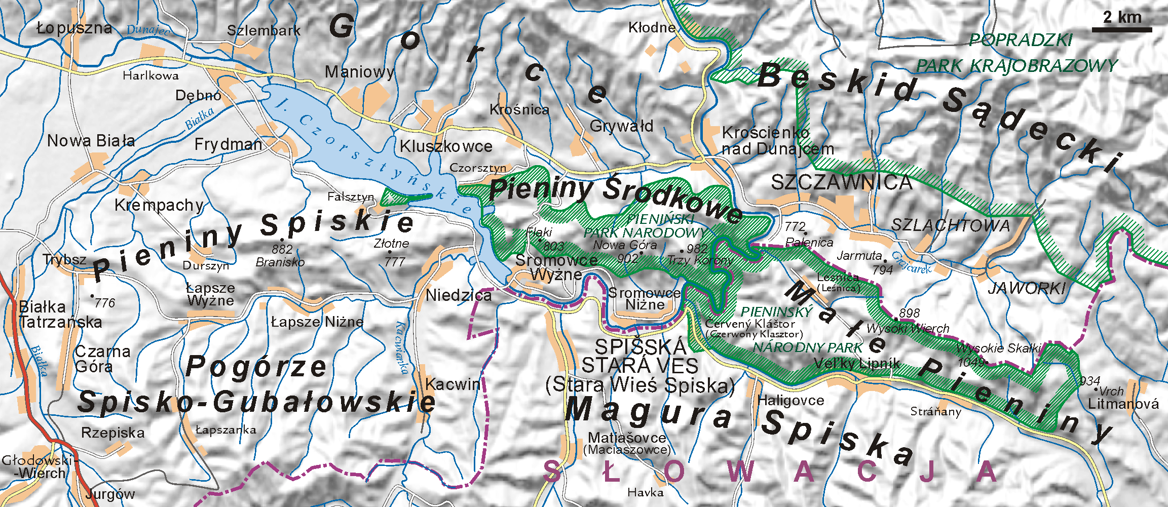
The Dunajec (); Goral dialects: ''Dónajec'') is a river running through northeastern Slovakia and southern Poland. It is also regarded as the main river of the Goral Lands. It is a right tributary of the Vistula River. It begins in Nowy Targ at the junction of two short mountain rivers, Czarny Dunajec and Biały Dunajec (Black and White Dunajec). Dunajec forms the border between Poland and Slovakia for in the Pieniny Środkowe (Slovak: Centrálne Pieniny) range, east of the Czorsztyn reservoir. Geography The Dunajec is long, including its source river Czarny Dunajec,Statistical Yearbook of the Republic of Poland 2017 |
Hornád
Hornád ( Slovak, ) or Hernád ( Hungarian, ) is a river in eastern Slovakia and north-eastern Hungary. It is a tributary to the river Slaná (Sajo). The source of the Hornád is the eastern slopes of Kráľova hoľa hill, south of Šuňava. The river is 286 km long, with 178 km located in Slovakia, and the remaining 108 km in Hungary. Cities along its course are Spišská Nová Ves and Košice, both in Slovakia. It flows into the river Sajó ( Slovak Slaná) southeast of Miskolc. Along the river are a series of six separate limestone rocky cliffs and steep slopes, which collectively make up the Site of Community Importance A Site of Community Importance (SCI) is defined in the European Commission Habitats Directive (92/43/EEC) as a site which, in the biogeographical region or regions to which it belongs, contributes significantly to the maintenance or restoration at ... 'Hornádske vápence'. References Rivers of Slovakia Rivers of Hungary Spiš I ... [...More Info...] [...Related Items...] OR: [Wikipedia] [Google] [Baidu] |
Baltic Sea
The Baltic Sea is an arm of the Atlantic Ocean that is enclosed by Denmark, Estonia, Finland, Germany, Latvia, Lithuania, Poland, Russia, Sweden and the North and Central European Plain. The sea stretches from 53°N to 66°N latitude and from 10°E to 30°E longitude. A marginal sea of the Atlantic, with limited water exchange between the two water bodies, the Baltic Sea drains through the Danish Straits into the Kattegat by way of the Øresund, Great Belt and Little Belt. It includes the Gulf of Bothnia, the Bay of Bothnia, the Gulf of Finland, the Gulf of Riga and the Bay of Gdańsk. The " Baltic Proper" is bordered on its northern edge, at latitude 60°N, by Åland and the Gulf of Bothnia, on its northeastern edge by the Gulf of Finland, on its eastern edge by the Gulf of Riga, and in the west by the Swedish part of the southern Scandinavian Peninsula. The Baltic Sea is connected by artificial waterways to the White Sea via the White Sea–Baltic Canal and to the German ... [...More Info...] [...Related Items...] OR: [Wikipedia] [Google] [Baidu] |
Poprad River
The Poprad ( hu, Poprád, links=no, german: Popper, links=no) is a river in northern Slovakia and southern Poland, and a tributary of the Dunajec River near Stary Sącz, Poland. It has a length of 170 kilometres (63 km of which are within the Polish borders) and a basin area of 2,077 km2, (1,594 km2 of which is in Slovakia, and 483 km2 in Poland). Much of the Polish part of its basin is included in the protected area called Poprad Landscape Park featuring the Poprad River Gorge, a popular tourist destination between the towns of Piwniczna and Rytro. Poprad is the only large Slovak river flowing north into southern Poland. The river flows through the Slovak towns of Poprad, Kežmarok, Stará Ľubovňa, then forms for 31.1 km the Polish-Slovak border and flows through the Polish towns of Krynica-Zdrój, Muszyna, Piwniczna-Zdrój, Rytro, Stary Sącz, and Żegiestów, among others. Etymology The name is derived from a Proto-Slavic verb ''pręd-'' (to fl ... [...More Info...] [...Related Items...] OR: [Wikipedia] [Google] [Baidu] |
Košice Basin
Košice ( , ; german: Kaschau ; hu, Kassa ; pl, Коszyce) is the largest city in eastern Slovakia. It is situated on the river Hornád at the eastern reaches of the Slovak Ore Mountains, near the border with Hungary. With a population of approximately 230,000, Košice is the second-largest city in Slovakia, after the capital Bratislava. Being the economic and cultural centre of eastern Slovakia, Košice is the seat of the Košice Region and Košice Self-governing Region, and is home to the Slovak Constitutional Court of Slovakia, Constitutional Court, three universities, various dioceses, and many museums, galleries, and theatres. In 2013 Košice was the European Capital of Culture, together with Marseille, France. Košice is an important industrial centre of Slovakia, and the U. S. Steel Košice, s.r.o., U.S. Steel Košice steel mill is the largest employer in the city. The town has extensive railway connections and an Košice International Airport, international airport. T ... [...More Info...] [...Related Items...] OR: [Wikipedia] [Google] [Baidu] |
Podtatranská Kotlina
The Podtatranská kotlina (literally Sub-Tatra Basin or Basin under Tatra(s)) is a basin in northern Slovakia, part of the Fatra-Tatra Area, which belongs to the Inner Western Carpathians. Towns and cities include Ružomberok, Liptovský Mikuláš, Liptovský Hrádok, Svit, Poprad, Kežmarok, Spišská Belá and Podolínec. Location and characteristics The Podtatranská kotlina is oriented on an east-west axis and is around long and around wide in the north-south direction. It borders: *Tatras in the north * Spišská Magura in the north-east *Levoča Hills in the east *Kozie chrbty in the south-east *Low Tatras in the south *Greater Fatra in the south-west *Choč Mountains in the north-west The basin is divided into three sub-divisions: ''Liptovská kotlina'' (Liptov Basin), ''Popradská kotlina'' (Poprad Basin) and ''Tatranské predhorie'', also called ''podhorie'' (Tatra Piedmont). The border between the former named basins is also the drainage divide; the Váh River d ... [...More Info...] [...Related Items...] OR: [Wikipedia] [Google] [Baidu] |
Eastern Slovak Lowland
The East(ern) Slovak Lowland ( Slovak: ''Východoslovenská nížina'') is the name of a part of the Great Hungarian Plain (Slovak: ''Veľká dunajská kotlina'') situated in Slovakia. In terms of geomorphology, it forms one unit together with the Tisza Lowland (''Tiszamenti síkság'') in Hungary, the Transcarpathian Lowland (''Zakarpats'ka nyzovyna'') in Ukraine, and the plain ''Câmpia Someşului'' in Romania. It consists of the following two parts: * Eastern Slovak Hills (also translated as Eastern Slovak Upland) in the west and the north; and * Eastern Slovak Flat The East(ern) Slovak Flat (Slovak: ''Východoslovenská rovina''), also translated as Eastern Slovak Plain, is the lower, flat part of the Eastern Slovak Lowland. Important towns: Trebišov, Michalovce, Veľké Kapušany, Kráľovský Chlmec, Sob ... (also translated as Eastern Slovak Plain) in the middle, east and south. References {{Authority control Plains of Slovakia Pannonian Plain ... [...More Info...] [...Related Items...] OR: [Wikipedia] [Google] [Baidu] |


