|
Powhite Park
Powhite Park is a 100-acre park in the city limits of Richmond, Virginia. It is close to the junction of Powhite parkway, Chippenham Parkway and Jahnke road. This park is notable for its pristinity and beaver dam A beaver dam or beaver impoundment is a dam built by beavers to create a pond which protects against predators such as coyotes, wolves and bears, and holds their food during winter. These structures modify the natural environment in such a way t ..., considering the park is in city limits. The park is also populated by deer. The bike trail is considered moderate. References External links Richmond Times Dispatch Report on the park Parks in Richmond, Virginia {{RichmondCityVA-geo-stub ... [...More Info...] [...Related Items...] OR: [Wikipedia] [Google] [Baidu] |
Virginia State Route 76
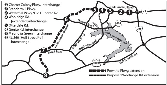
State Route 76 (SR 76) is a state highway in the U.S. state of Virginia. Known as Powhite Parkway (first word officially pronounced , similar to Powhatan), the state highway runs from SR 652 near Midlothian north to Interstate 195 (I-195) in Richmond. SR 76 is a toll freeway that connects SR 288, U.S. Route 60 (US 60), and SR 150 in Chesterfield County with I-195 and SR 195 west of Downtown Richmond. The highway includes a pair of mainline barrier toll plazas and ramp toll plazas at most interchanges, all of which accept E-ZPass. SR 76 is maintained by the Virginia Department of Transportation (VDOT) in Chesterfield County and the Richmond Metropolitan Authority in the city of Richmond. The Richmond section of the freeway was constructed in the early 1970s; the highway was extended to its current terminus in Chesterfield County in the late 1980s. Route description SR 76 begins at an arbitrary point just east of an intersection with Brandermill Parkway, the main stree ... [...More Info...] [...Related Items...] OR: [Wikipedia] [Google] [Baidu] |
Richmond, Virginia
(Thus do we reach the stars) , image_map = , mapsize = 250 px , map_caption = Location within Virginia , pushpin_map = Virginia#USA , pushpin_label = Richmond , pushpin_map_caption = Location within Virginia##Location within the contiguous United States , pushpin_relief = yes , coordinates = , subdivision_type = Country , subdivision_name = , subdivision_type1 = U.S. state, State , subdivision_name1 = , established_date = 1742 , , named_for = Richmond, London, Richmond, United Kingdom , government_type = , leader_title = List of mayors of Richmond, Virginia, Mayor , leader_name = Levar Stoney (Democratic Party (United States), D) , total_type = City , area_magnitude = 1 E8 , area_total_sq_mi = 62.57 , area_land_sq_mi = 59.92 , area_ ... [...More Info...] [...Related Items...] OR: [Wikipedia] [Google] [Baidu] |
Virginia State Route 150
State Route 150 (SR 150) is a state highway in the U.S. state of Virginia. Known as Chippenham Parkway, the state highway runs from Interstate 95 (I-95) and SR 895 in Bensley north to Parham Road and River Road near Tuckahoe in Henrico County. SR 150 is a four- to six-lane circumferential highway that connects the Chesterfield County suburbs of Richmond with western Henrico County and, via SR 895, eastern Henrico County and Richmond International Airport. The highway is a freeway except for a short stretch east of SR 147 in Richmond. SR 150 has junctions with all of the radial highways south of the James River, including I-95, U.S. Route 1 (US 1), US 301, US 360, US 60, and SR 76. Route description SR 150 begins at an interchange with I-95 (Richmond–Petersburg Turnpike) and SR 895 (Pocahontas Parkway) in Bensley in eastern Chesterfield County. The interchange has two parts: SR 150 proper has a standard semi-directional three-way interchange with I-95. West of w ... [...More Info...] [...Related Items...] OR: [Wikipedia] [Google] [Baidu] |
Beaver Dam
A beaver dam or beaver impoundment is a dam built by beavers to create a pond which protects against predators such as coyotes, wolves and bears, and holds their food during winter. These structures modify the natural environment in such a way that the overall ecosystem builds upon the change, making beavers a keystone species and ecosystem engineers. They build prolifically at night, carrying mud and stones with their forepaws and timber between their teeth. Construction A minimum water level of is required to keep the underwater entrance to beaver lodges from being blocked by ice during the winter. In lakes, rivers and large streams with deep enough water, beavers may not even need to build dams, and instead simply live in bank burrows and lodges. If the water is not deep enough to keep beavers safe from predators and their lodge entrances ice-free, beavers build dams.Beavers start construction by diverting the stream to lessen the water's flow pressure. Branches and logs ar ... [...More Info...] [...Related Items...] OR: [Wikipedia] [Google] [Baidu] |

