|
Plymouth MBTA Station
Plymouth station is a closed MBTA Commuter Rail station in Plymouth, Massachusetts. It served the Plymouth/Kingston Line and was located in the Cordage Park complex of North Plymouth. Plymouth was one terminus of the MBTA's Kingston/Plymouth Line, along with Kingston/Route 3 station in nearby Kingston, Massachusetts. Plymouth station provided non-peak service to Boston's South Station South Station, officially The Governor Michael S. Dukakis Transportation Center at South Station, is the largest railroad station and intercity bus terminal in Greater Boston and New England's second-largest transportation center after Logan In ..., as well as some peak service, which ran in addition to peak trips to Kingston. Most trains on the line served only Kingston station; service to and ridership from Plymouth were thus very limited. Due to this limited ridership and service, as well as due to the fact that trains had to reverse in and out of the station in order to serve it, Plymouth st ... [...More Info...] [...Related Items...] OR: [Wikipedia] [Google] [Baidu] |
Massachusetts Route 3A
Route 3A is a state highway in eastern Massachusetts, which parallels Route 3 and U.S. Route 3 from Cedarville in southern Plymouth to Tyngsborough at the New Hampshire state line. Route 3A has two major posted segments, separated by a lengthy concurrency with Route 3 and US 3. Its southern portion parallels Route 3 from Cedarville in southern Plymouth to Neponset in the Dorchester area of Boston. Towns and cities that Route 3A traverse along its path include Plymouth, Kingston, Duxbury, Marshfield, Scituate, Cohasset, Hingham, Weymouth and Quincy. North of Neponset, Route 3A runs, unsigned, concurrently with Route 3 and U.S. Route 3 to Burlington, before separating again (MassDOT counts the mileage along MA 3 between the two sections as part of MA 3A mileage). The northern portion of Route 3A parallels U.S. Route 3 in northwestern Middlesex County. It stretches from Interstate 95 (Route 128) in Burlington to the New Hampshire state line, where it continues as Rou ... [...More Info...] [...Related Items...] OR: [Wikipedia] [Google] [Baidu] |
Kingston, Massachusetts
Kingston is a coastal town in Plymouth County, Massachusetts, United States. The population was 13,708 at the 2020 census. History Before European settlers arrived, Kingston was within the tribal homeland of the Wampanoag people. Several years before the ''Mayflower'' had landed in Plymouth, during the Native American epidemic of 1616 to 1619, the Wampanoag population was severely damaged from a rapidly spreading pandemics due to earlier contacts with Europeans. Several ancient Native American burial sites have been located within the borders of Kingston. Originally part of Plymouth, Kingston was first settled by Europeans shortly after the landing of the Pilgrims at Plymouth Rock in 1620. It was settled once more in 1635. During 1675, several bloody battles during King Philip's War are believed to have occurred within Kingston's borders and the residence of Governor Bradford, which is now part of Kingston, was raided by Wampanoag warriors. In 1685, the area was placed with ... [...More Info...] [...Related Items...] OR: [Wikipedia] [Google] [Baidu] |
Middleborough/Lakeville Line
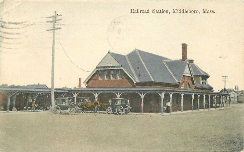
Middleborough/Lakeville station is an MBTA Commuter Rail station in Lakeville, Massachusetts, just south of the Middleborough border. It is the southern terminus of the Middleborough/Lakeville Line; it is also an intermediate stop for seasonal CapeFlyer service to Cape Cod. Middleborough/Lakeville has a single full-length high-level side platform serving the line's single track. An older station was located in downtown Middleborough, serving passenger service from 1846 to 1959 and Cape Cod and Hyannis Railroad service from 1984 to 1988. The current station opened along with the rest of the Old Colony Lines on September 29, 1997, and CapeFlyer service began in 2013. The station is planned to be closed to commuter rail service when the new Middleborough station opens in 2023 as part of South Coast Rail, though it will remain open for CapeFlyer and additional commuter parking. Station layout The station is located on Commercial Drive off South Main Street (Massachusetts Route 1 ... [...More Info...] [...Related Items...] OR: [Wikipedia] [Google] [Baidu] |
Old Colony Lines
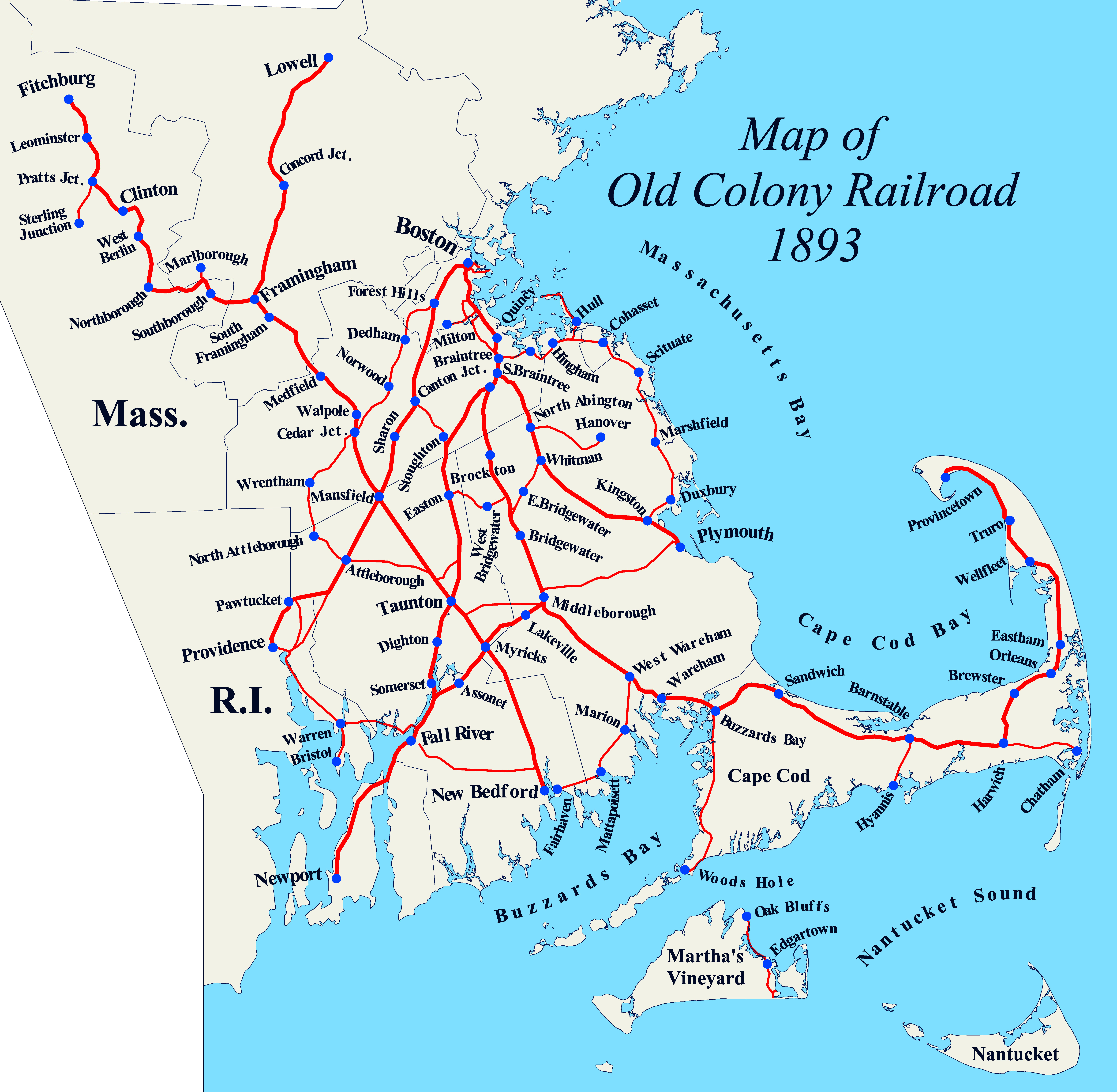
The Old Colony Lines are a pair of branches of the MBTA Commuter Rail system, connecting downtown Boston, Massachusetts with the South Shore and cranberry-farming country to the south and southeast. The two branches operate concurrently for via the Old Colony Mainline from South Station to Braintree station. The Middleborough/Lakeville Line then winds south through Holbrook, Brockton, Bridgewater, Middleborough, and Lakeville via the Middleborough Main Line and Cape Main Line. The Kingston/Plymouth Line heads southeast to serve Weymouth, Abington, Whitman, Hanson, Halifax, Kingston, and Plymouth by way of the Plymouth branch. History The Old Colony under the New Haven Historically, train service extended beyond the current terminus of the three branches. Greenbush service continued on a now-abandoned right-of-way to Kingston, where it joined the Plymouth line. The Plymouth line extended into downtown Plymouth, and a branch connected to Middleborough through Carver. ... [...More Info...] [...Related Items...] OR: [Wikipedia] [Google] [Baidu] |
Railway And Locomotive Historical Society Bulletin
''Railroad History'' (initially, ''The Railway & Locomotive Historical Society Bulletin'') is a biannual peer-reviewed academic journal published by the Railway & Locomotive Historical Society since 1921. ''Railroad History'' consists primarily of articles about the history of rail transport with some essays and book reviews __NOTOC__ A book review is a form of literary criticism in which a book is merely described (summary review) or analyzed based on content, style, and merit. A book review may be a primary source, opinion piece, summary review or scholarly revie .... As of 2022, its editor is Dan Cupper. The RLHS is a non-profit organization founded in 1921 in the United States to promote research into and preservation of documentation and photography of railroad-related business, finance, labor, biography, and technology. History The journal began publication in 1921 as ''The Railway & Locomotive Historical Society Bulletin''. The journal's title was changed to ''Rai ... [...More Info...] [...Related Items...] OR: [Wikipedia] [Google] [Baidu] |
Massachusetts Bay Transportation Authority MBTA 1060 (F40PH2C) (10567688246)
Massachusetts (Massachusett: ''Muhsachuweesut məhswatʃəwiːsət">Massachusett writing systems">məhswatʃəwiːsət'' English: , ), officially the Commonwealth of Massachusetts, is the most populous state in the New England region of the Northeastern United States. It borders on the Atlantic Ocean and Gulf of Maine to the east, Connecticut and Rhode Island to the south, New Hampshire and Vermont to the north, and New York to the west. The state's capital and most populous city, as well as its cultural and financial center, is Boston. Massachusetts is also home to the urban core of Greater Boston, the largest metropolitan area in New England and a region profoundly influential upon American history, academia, and the research economy. Originally dependent on agriculture, fishing, and trade. Massachusetts was transformed into a manufacturing center during the Industrial Revolution. During the 20th century, Massachusetts's economy shifted from manufacturing to services. M ... [...More Info...] [...Related Items...] OR: [Wikipedia] [Google] [Baidu] |
Cordage Station 1930 Postcard
{{disambiguation ...
Cordage may refer to: * Rigging, cords and ropes attached to masts and sails on a ship or boat * Rope, yarns, plies or strands twisted or braided together into a larger form See also * String (other) * Cord (other) * Rope (other) Rope is a length of fibers that are twisted or braided together Rope may also refer to: *Wire rope, a length of metallic fibers twisted or braided together Computing * Core rope memory, a ferrite read-only memory * IpTables Rope, an open-sourc ... [...More Info...] [...Related Items...] OR: [Wikipedia] [Google] [Baidu] |
South Station
South Station, officially The Governor Michael S. Dukakis Transportation Center at South Station, is the largest railroad station and intercity bus terminal in Greater Boston and New England's second-largest transportation center after Logan International Airport. Located at the intersection of Atlantic Avenue and Summer Street in Dewey Square, Boston, Massachusetts, the historic station building was constructed in 1899 to replace the downtown terminals of several railroads. Today, it serves as a major intermodal domestic transportation hub, with service to the Greater Boston region and the Northeastern and Midwestern United States. It is used by thousands of commuter rail and intercity rail passengers daily. Connections to the rapid transit Red Line and bus rapid transit Silver Line are made through the adjacent subway station. The station was renamed for former Massachusetts governor Michael S. Dukakis in November 2014, though maps and station signs continue to use the ... [...More Info...] [...Related Items...] OR: [Wikipedia] [Google] [Baidu] |
Kingston/Route 3 Station
Kingston station (formerly Kingston/Route 3) is an MBTA Commuter Rail serving the Plymouth/Kingston Line, located off of Massachusetts Route 3 south of downtown Kingston, Massachusetts. It opened in 1997 during the restoration of Old Colony Lines service. Like all stations on the Old Colony Lines, Kingston station is fully accessible. The station consists of a single side platform serving the single track. Marion Drive, the access road for the station parking lot, crosses the line at grade just east of the platform. The Kingston layover yard is located just west of the station. History The Old Colony Railroad's Kingston station was located in downtown Kingston off Summer Street ( Route 3A). The original station was replaced in 1889. It was the southern terminus of the South Shore Line until 1938. Boston–Plymouth service ended in 1959, though the station is still extant and used as a restaurant. The station was built to provide a park and ride station for Route 3 so that tr ... [...More Info...] [...Related Items...] OR: [Wikipedia] [Google] [Baidu] |
Plymouth, Massachusetts
Plymouth (; historically known as Plimouth and Plimoth) is a town in Plymouth County, Massachusetts, United States. Located in Greater Boston, the town holds a place of great prominence in American history, folklore, and culture, and is known as "America's Hometown". Plymouth was the site of the colony founded in 1620 by the ''Mayflower'' Pilgrims, where New England was first established. It is the oldest municipality in New England and one of the oldest in the United States. The town has served as the location of several prominent events, one of the more notable being the First Thanksgiving feast. Plymouth served as the capital of Plymouth Colony from its founding in 1620 until the colony's merger with the Massachusetts Bay Colony in 1691. The English explorer John Smith named the area Plymouth (after the city in South West England) and the region 'New England' during his voyage of 1614 (the accompanying map was published in 1616). It was a later coincidence that, after an ab ... [...More Info...] [...Related Items...] OR: [Wikipedia] [Google] [Baidu] |
North Plymouth, Massachusetts
North Plymouth is a census-designated place (CDP) in the town of Plymouth in Plymouth County, Massachusetts, United States. The population was 3,600 at the 2010 census. it is best known as the location of Cordage Park, a small village where the Plymouth Cordage Company was once headquartered. The village is now home to Cordage Commerce Center, a large retail development that consists of offices and stores. Geography North Plymouth is located at (41.971285, -70.686980). According to the United States Census Bureau, the CDP has a total area of 9.1 km (3.5 mi), of which 3.3 km (1.3 mi) is land and 5.8 km (2.2 mi) (63.71%) is water. Demographics As of the census of 2000, there were 3,593 people, 1,506 households, and 884 families residing in the CDP. The population density was 1,092.3/km (2,832.7/mi). There were 1,580 housing units at an average density of 480.3/km (1,245.7/mi). The racial makeup of the CDP was 93.46% White, 1.95% African American, ... [...More Info...] [...Related Items...] OR: [Wikipedia] [Google] [Baidu] |


