|
Plomesgate Hundred
Plomesgate is a hundred of Suffolk, consisting of . Plomesgate Hundred comprises the historic ports of Aldeburgh and Orford, the medieval market town of Saxmundham and twenty other parishes in the east of the county. It forms a strip around 14 miles long and up to 9 miles wide running south-east from near Framlingham to the North Sea. It is bounded on the east by the sea, on the north by Blything Hundred, on the west by Hoxne and Loes Hundreds and on the south by the Butley River which flows into the River Ore near Orford Ness. The hundred is watered by the River Alde and its tributary streams and is generally a fertile loamy district with hills rising from the valleys and the coast and with sandy beaches in southern parts. It is in the Deanery of Orford in the Archdeaconry of Suffolk. Listed as ''Plumesgata'' in the ''Domesday Book Domesday Book () – the Middle English spelling of "Doomsday Book" – is a manuscript record of the "Great Survey" of much of Englan ... [...More Info...] [...Related Items...] OR: [Wikipedia] [Google] [Baidu] |
Hundred (subdivision)
A hundred is an administrative division that is geographically part of a larger region. It was formerly used in England, Wales, some parts of the United States, Denmark, Southern Schleswig, Sweden, Finland, Norway, the Bishopric of Ösel–Wiek, Curonia, the Ukrainian state of the Cossack Hetmanate and in Cumberland County, New South Wales, Cumberland County in the British Colony of New South Wales. It is still used in other places, including in Australia (in South Australia and the Northern Territory). Other terms for the hundred in English and other languages include ''#wapentake, wapentake'', ''herred'' (Danish and Bokmål, Bokmål Norwegian), ''herad'' (Nynorsk, Nynorsk Norwegian), ''hérað'' (Icelandic), ''härad'' or ''hundare'' (Swedish), ''Harde'' (German), ''hiird'' (North Frisian language, North Frisian), ''satakunta'' or ''kihlakunta'' (Finnish), ''kihelkond'' (Estonian), ''kiligunda'' (Livonian), ''cantref'' (Welsh) and ''sotnia'' (Slavic). In Ireland, a similar subdi ... [...More Info...] [...Related Items...] OR: [Wikipedia] [Google] [Baidu] |
Blaxhall
Blaxhall is a village and civil parish in the East Suffolk district of the English county of Suffolk. Located around south-west of Leiston and Aldeburgh, in 2007 its population was estimated to be 220, measured at 194 in the 2011 Census.Civil Parish population 2011 Retrieved 2015-09-16. The parish council owns Blaxhall Common, a Site of Special Scientific Interest located on the |
Sternfield
Sternfield is a village in Suffolk, England. It is located south of Saxmundham, its post town. The village is very small and irregularly built, and is wholly agricultural. The village contains a church dedicated to Mary Magdalene. It is Grade II* listed for its surviving medieval work, notably the south porch and tower. During the 1960s and 1970s Lt. Col. Sir Eric and Lady Penn lived at Sternfield House, a large house next to the church with extensive gardens and as Sir Eric was the comptroller of the Lord Chamberlain's Office and a trusted presence in Buckingham Palace, senior members of the royal family came and stayed at Sternfield House on a number of occasions. Princess Margaret came most often, but the Queen also came at least once and attended St Mary Magdalene's, as did the Queen Mother. Another notable property is Sternfield Hall, with its classic Georgian soft red brick facade and late 16th-century wing which is probably the site of a medieval manor house where on ... [...More Info...] [...Related Items...] OR: [Wikipedia] [Google] [Baidu] |
Snape, Suffolk
Snape is a small village in the English county of Suffolk, on the River Alde close to Aldeburgh. At the 2011 census the population was 611. In Anglo-Saxon England, Snape was the site of an Anglo-Saxon ship burial. Snape is now best known for Snape Maltings, no longer in commercial use, but converted into a tourist centre together with a concert hall that hosts the major part of the annual Aldeburgh Festival. Early history There has been human habitation at Snape for some 2,000 years though the original village stood on higher ground, around the present church (it is not known why the village moved nearer to the river). The Romans established a settlement here, centred on salt production. In Anglo-Saxon times the Wuffingas (who ruled East Anglia from Rendlesham) used Snape largely as a burial site, and archaeological investigations have revealed ship burials and other graves. In 1085 the Domesday Book recorded forty-nine men. The book also mentions a church, standing in e ... [...More Info...] [...Related Items...] OR: [Wikipedia] [Google] [Baidu] |
Rendham
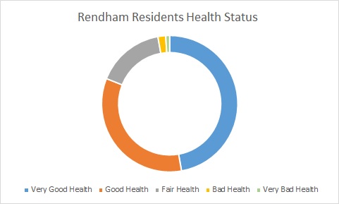
Rendham is a village and civil parish on the B1119 road, in the East Suffolk district, in the English county of Suffolk. It is near the town Saxmundham and the village Sweffling. Etymology Rendham comes from Old English and Saxon. Rend is the Old English "rymed" meaning cleared. "Ham" is Saxon, meaning village. Rendham therefore means cleared village, taken from that the village being placed in a clearing by the River Alde, surrounded by woodland. Geography Rendham lies on the River Alde, near its confluence with The Gull which diverts to Sweffling downstream from Rendham. The surrounding area is rural, farmland dotted with small areas of woodland. Rendham has two village greens called Rendham Green and The Knoll which are owned by the local Parish. Between 1870 and 1872, Rendham's location was described in John Marius Wilson's ''Imperial Gazetteer of England and Wales'': Rendham has a healthy populous, the majority of the population (175 people) in 2011 having very good ... [...More Info...] [...Related Items...] OR: [Wikipedia] [Google] [Baidu] |
Parham, Suffolk
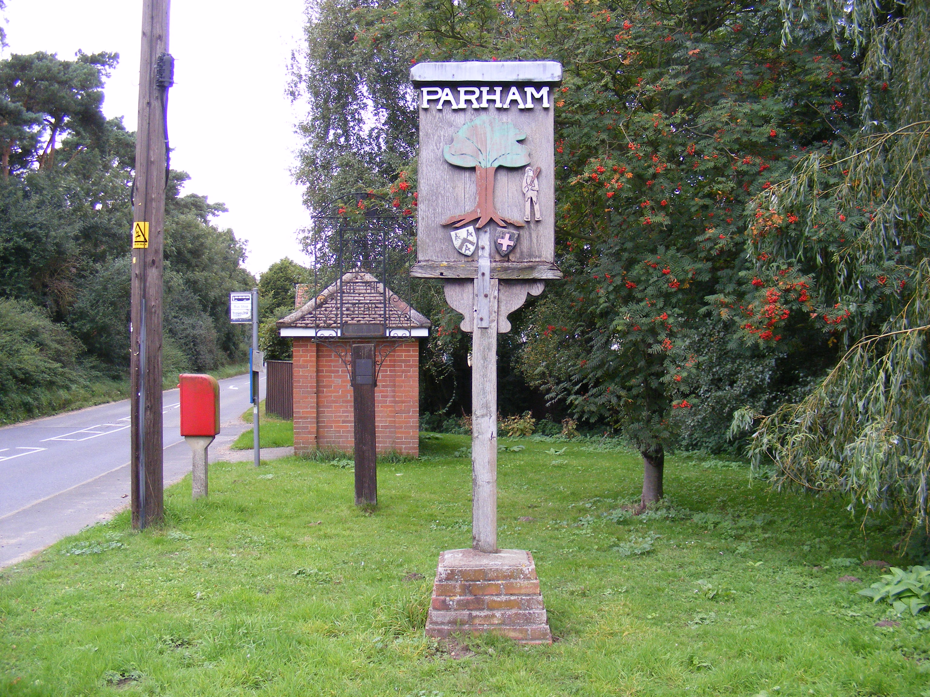
Parham is a village and civil parish in the East Suffolk district of Suffolk in eastern England. Located seven miles north of Woodbridge, in 2005 it had a population of 300, reducing to 263 at the 2011 census and according to the 2011 census there were 129 males and 134 females living at this time. The flint-built parish church of St Mary, though restored in 1886, dates from the late 14th Century and was likely built for William de Ufford. The Rood screen is from the 15th Century. Parham is located on the B1116. William Willoughby, 1st Baron Willoughby of Parham is interred in the church, too. Parham Airfield Museum is located nearby. Parham railway station, on the Framlingham Branch, was shut to passenger traffic in November 1952. Between 1870 and 1872 John Marius Wilson's Imperial Gazetteer visited Parham and wrote the following as an entry for the parish.PARHAM, a village and a parish in Plomesgate district, Suffolk. The village stands on the river Ore, adjacent to t ... [...More Info...] [...Related Items...] OR: [Wikipedia] [Google] [Baidu] |
Iken
Iken is a small village and civil parish in the sandlands of the English county of Suffolk, an area formerly of heathland and sheep pasture. It is near the estuary of the River Alde on the North Sea coast and is located south east of Snape and due north of Orford. To its west is Tunstall Forest, created since the 1920s by the Forestry Commission and now part of the Sandlings Forest. Iken was part of Sudbourne Hall Estate. It was composed largely of tenant farms and cottages for farm workers. The owners of the estate valued the area more for shooting than farming, and a decoy pond was built at Iken in the eighteenth century. Since the break up of the Estate Iken has remained a "close" village: only a handful of new houses have been built and no council houses have ever been built. In the pre-railway era Iken Cliff was a commercial area used for transporting coal and wheat, and there was a public house near the shore. Flat barges used to sit on the mud at low tide and goods wer ... [...More Info...] [...Related Items...] OR: [Wikipedia] [Google] [Baidu] |
Little Glemham
Little Glemham is a small village on the A12 road, in the East Suffolk district East Suffolk is a local government district in Suffolk, England, which was established on 1 April 2019, following the merger of the existing Suffolk Coastal and Waveney districts. At the 2011 census, the two districts had a combined population o ..., in the county of Suffolk, England. The population of the parish at the 2011 Census was 187. Nearby settlements include the villages of Wickham Market and Marlesford. Little Glemham has a church, St. Andrew's, a pub and a hall called Glemham Hall. The corresponding village of Great Glemham is a few miles away. References Suffolk Churches Villages in Suffolk Civil parishes in Suffolk {{Suffolk-geo-stub ... [...More Info...] [...Related Items...] OR: [Wikipedia] [Google] [Baidu] |
Great Glemham
Great Glemham is a village and civil parish in the East Suffolk district, England, a mile and a half to the west of the A12 and roughly equidistant between Framlingham and Saxmundham. The parish takes the shape of an irregular triangle formed by two clay ridges flanking rolling countryside through which runs the channel of a seasonal watercourse, the Gull, flowing NW to SE to join the upper River Alde, which forms the village's eastern boundary. The civil parish had a population of 224 at the 2011 Census. The centre of the village is a Conservation area with numerous historic and listed buildings including its Grade I listed church, The Crown Inn and K6 telephone box. The place-name 'Glemham' is first recorded in the Domesday Book of 1086, where it appears as ''Gl(i)emham'', in the manors of Edwin Grim and Spearhafoc of ''Glaimham''. Eilert Ekwall comments: "The first element of the names is possibly Old English ''glēam'' 'merriment'..." By analogy with Glandford in Norfolk ... [...More Info...] [...Related Items...] OR: [Wikipedia] [Google] [Baidu] |
Friston
Friston is a village and civil parish in the East Suffolk district, in the county of Suffolk, England. It is southeast of Saxmundham, its post town, and northwest of Aldeburgh. The River Alde bounds the village on the south. The surrounding land is chiefly arable. The soil becomes partly marshy in the lower grounds. The village is noted for its early nineteenth century post mill. It is located next to the village of Knodishall. Its name is recorded in the Domesday Book as ''Frisetuna'' and seems to come from Anglo-Saxon ''Frīsa tūn'' = "the farmstead of the Frisians"; some of them may have come with the Angles and Saxons The Saxons ( la, Saxones, german: Sachsen, ang, Seaxan, osx, Sahson, nds, Sassen, nl, Saksen) were a group of Germanic * * * * peoples whose name was given in the early Middle Ages to a large country (Old Saxony, la, Saxonia) near the Nor .... An alternative name for the parish is Freston. In 1887, John Bartholomew described Friston as:Frist ... [...More Info...] [...Related Items...] OR: [Wikipedia] [Google] [Baidu] |
Farnham, Suffolk
Farnham is a village and civil parish about south-west of Saxmundham in the English county of Suffolk on the A12 road. Farnham is located west of Friday Street, south of Benhall Low Street and north-east of Stratford St Andrew. History The village of Farnham gets its name from Old English where it means "Fern hemmed-in land" or "Fern homestead/village". The earliest known recording of the village of Farnham is from the Domesday Book, written in 1086, where it appears three times. Farnham was located in the Hundred of Plomesgate in the County of Suffolk and had a population of 18 households; 8 smallholders and 13 free men. Farnham also had one Lord's plough teams and 2 men's plough teams. In addition to this the Domesday Book also had 2 mills and 21 acres of meadow recorded St. Mary's Church was not recorded in the Domesday Book.In 1870–72 John Marius Wilson described Farnham, in John Marius Wilson's Imperial Gazetteer of England and Wales, as:"A parish in Plomesgate district ... [...More Info...] [...Related Items...] OR: [Wikipedia] [Google] [Baidu] |

.jpg)


