|
Phugwane River
The Phugwane River is a river in Limpopo Province, South Africa. It is a left hand tributary of the Shingwedzi River and the northernmost river of its catchment area, joining it in the middle of its basin. The Phugwane is a seasonal river whose riverbed is dry for prolonged periods. Course The Phugwane River drains the plain southeast of the Soutpansberg. Its sources are about 40 km to the ESE of Thohoyandou In the Mulamulele area it flows eastwards across the lowveld and passes through three villages(Madonsi,Phugwani and Magona) before entering the area of the Kruger National Park. pne One of its tributary is Shiwamseve which drains its waters from the left side in the Phugwani areaRivers of the Kruger National Park... Perennial and Seasonal/ref> See also * Kruger National Park Kruger National Park is a South African National Park and one of the largest game reserves in Africa. It covers an area of in the provinces of Limpopo and Mpumalanga in northeastern South ... [...More Info...] [...Related Items...] OR: [Wikipedia] [Google] [Baidu] |
South Africa
South Africa, officially the Republic of South Africa (RSA), is the southernmost country in Africa. It is bounded to the south by of coastline that stretch along the South Atlantic and Indian Oceans; to the north by the neighbouring countries of Namibia, Botswana, and Zimbabwe; and to the east and northeast by Mozambique and Eswatini. It also completely enclaves the country Lesotho. It is the southernmost country on the mainland of the Old World, and the second-most populous country located entirely south of the equator, after Tanzania. South Africa is a biodiversity hotspot, with unique biomes, plant and animal life. With over 60 million people, the country is the world's 24th-most populous nation and covers an area of . South Africa has three capital cities, with the executive, judicial and legislative branches of government based in Pretoria, Bloemfontein, and Cape Town respectively. The largest city is Johannesburg. About 80% of the population are Black South Afri ... [...More Info...] [...Related Items...] OR: [Wikipedia] [Google] [Baidu] |
Limpopo Province
Limpopo is the northernmost Provinces of South Africa, province of South Africa. It is named after the Limpopo River, which forms the province's western and northern borders. The capital and largest city in the province is Polokwane, while the provincial legislature is situated in Lebowakgomo. The province is made up of 3 former homelands of Lebowa, Gazankulu and Venda and the former parts of the Transvaal province. The Limpopo province was established as one of the new nine provinces after South Africa's first democratic election on the 27th of April 1994. The province's name was first "Northern Transvaal", later changed to "Northern Province" on the 28th of June 1995, together with two other provinces. The name was later changed again in 2002 to the Limpopo province. Limpopo is made up of 3 main ethnic groups namely; Pedi people, Tsonga people, Tsonga and Venda people. Traditional leaders and chiefs still form a strong backbone of the province's political landscape. Establ ... [...More Info...] [...Related Items...] OR: [Wikipedia] [Google] [Baidu] |
Shingwedzi River
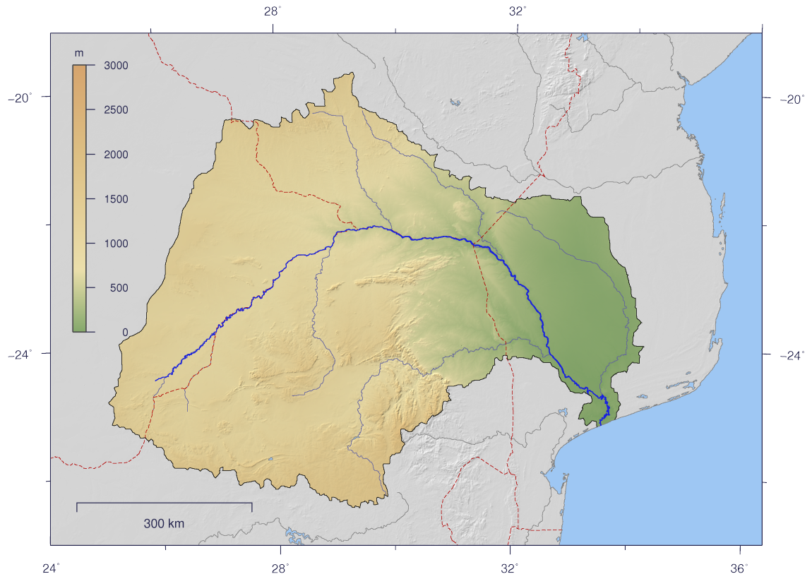
The Shingwedzi River ( ve, Tshingwedzi; ts, Xingwedzi/shingwedzi; af, Shingwedzirivier; pt, Rio Singuédzi) is a river in Limpopo Province, South Africa, and Gaza Province, Mozambique. It is a left hand tributary of the Olifants River (Limpopo), Olifants River ''(Rio dos Elefantes)'' and the northernmost river of its catchment area, joining it at the lower end of its basin. The Shingwedzi is a seasonal river whose riverbed is dry for prolonged periods. Course The Shingwedzi River drains the plain southeast of the Soutpansberg. Its sources are about 40 km to the ESE of Thohoyandou and about 20 km west of the town of Malamulele, in the Mulamula area. It flows eastwards across the lowveld and enters the area of the Kruger National Park. The main rivers of the Shingwedzi basin are the Mandzoro River, Mphongolo River, Phugwane River, Gole River, Shisha River, Tshamidzi River, Bububu River and the Dzombo River. Two dams on the river are located within the Kruger National ... [...More Info...] [...Related Items...] OR: [Wikipedia] [Google] [Baidu] |
Kruger National Park
Kruger National Park is a South African National Park and one of the largest game reserves in Africa. It covers an area of in the provinces of Limpopo and Mpumalanga in northeastern South Africa, and extends from north to south and from east to west. The administrative headquarters are in Skukuza. Areas of the park were first protected by the government of the South African Republic in 1898, and it became South Africa's first national park in 1926. To the west and south of the Kruger National Park are the two South African provinces of Limpopo and Mpumalanga, respectively. To the north is Zimbabwe, and to the east is Mozambique. It is now part of the Great Limpopo Transfrontier Park, a peace park that links Kruger National Park with the Gonarezhou National Park in Zimbabwe, and with the Limpopo National Park in Mozambique. The park is part of the Kruger to Canyons Biosphere, an area designated by the United Nations Educational, Scientific and Cultural Organization (UNES ... [...More Info...] [...Related Items...] OR: [Wikipedia] [Google] [Baidu] |
Soutpansberg
The Soutpansberg, (formerly ''Zoutpansberg'') meaning "Salt Pan Mountain" in Afrikaans, is a Mountain range, range of mountains in far northern South Africa. It is located in Vhembe District Municipality, Vhembe District, Limpopo. It is named for the Salt pan (geology), salt pan ( ve, Thavha ya muno, or "place of salt") located at its western end. The mountain range reaches the opposite extremity in the Matikwa Nature Reserve, some due east. The range as a whole had no Venda language, Venda name, as it was instead known by its sub-ranges which include Dzanani, Hanglip, Songozwi and others. Of late it is however known as Tha vhani ya muno, meaning "mountain of salt". The Soutpansberg forms part of the 'Vhembe Biosphere Reserve', which was designated as a biosphere reserve by UNESCO in 2009. The latter reserve also includes the Blouberg Range, Kruger National Park, Makgabeng Plateau, Makuleke Wetlands and the Mapungubwe Cultural Landscape. Geography The mountain is intersected by t ... [...More Info...] [...Related Items...] OR: [Wikipedia] [Google] [Baidu] |
Thohoyandou
Thohoyandou ( ve, Ṱhohoyanḓou) is a town in the Limpopo Province of South Africa. It is the administrative centre of Vhembe District Municipality and Thulamela Local Municipality. It is also known for being the former capital of the bantustan of Venda. History Thohoyandou became the capital of the former bantustan of Venda, while Dzanani is the traditional capital of Venda and the home of the VhaVenda kings. Thohoyandou name means "head of the elephant" in the Venda language, and was the name of one of the VhaVenda kings. Thohoyandou was built at Tshiluvhi which was under Khosi vho Netshiluvhi. Construction started in 1977 with P East and P West residential area/location as R293 town, a shopping centre and Venda Government buildings. The Netshiluvhis were the first occupants of the area as far back as 1400 AD, i.e. after the collapse of Mapungubwe Kingdom. They were forcefully removed from this area between 1960 and 1970 by the apartheid government of the Venda Bantustan und ... [...More Info...] [...Related Items...] OR: [Wikipedia] [Google] [Baidu] |
Lowveld
Veld ( or ), also spelled veldt, is a type of wide open rural landscape in :Southern Africa. Particularly, it is a flat area covered in grass or low scrub, especially in the countries of South Africa, Lesotho, Eswatini, Zimbabwe and Botswana. A certain sub-tropical woodland ecoregion of Southern Africa has been officially defined as the Bushveld by the World Wide Fund for Nature. Trees are not abundant—frost, fire and grazing animals allow grass to grow but prevent the build-up of dense foliage. Etymology The word ''veld'' () comes from the Afrikaans word for "field". The etymological origin is older modern Dutch ''veldt'', a spelling that the Dutch abandoned in favour of ''veld'' during the 19th century, decades before the first Afrikaans dictionary.Eric Anderson Walker (ed). The Cambridge History of the British Empire, Volume 4. Cambridge University Press 1963 (Afrikaans: pp. 890–894) A cognate to the English ''field'', it was spelt ''velt'' in Middle Dutch and ''fe ... [...More Info...] [...Related Items...] OR: [Wikipedia] [Google] [Baidu] |
List Of Rivers Of South Africa
This is a list of rivers in South Africa. It is quite common to find the Afrikaans word ''-rivier'' as part of the name. Another common suffix is "''-kamma''", from the Khoisan term for "river" Meiring, Barbara"South African Toponymic Guidelines for Map and other editors: Fourth Edition" 12. Retrieved on 30 April 2013. (often tautologically the English term "river" is added to the name). The Zulu word ''amanzi'' (water) also forms part of some river names. The Afrikaans term ''spruit'' (compare spring) often labels small rivers. List * A Drainage basin code assigned by the Department of Water Affairs (South Africa), a complete list is available at Drainage basins of South Africa Gallery Image:South Africa Topography.png, Topographic map of South Africa. Image:Orange watershed topo.png, Course and watershed of the Orange River with topography shading and political boundaries. Image:Groot River.jpg, Grootrivier in Nature's Valley, stained a tea colour by plant tannins ... [...More Info...] [...Related Items...] OR: [Wikipedia] [Google] [Baidu] |
Olifants River (Limpopo)
The Olifants River, Lepelle, iBhalule or Obalule ( af, Olifantsrivier; pt, Rio dos Elefantes) is a river in South Africa and Mozambique, a tributary of the Limpopo River. It falls into the Drainage Area B of the Drainage basins of South Africa. The historical area of the Pedi people, Sekhukhuneland, is located between the Olifants River and one of its largest tributaries, the Steelpoort River. Course The Olifants River has its origin between Breyten and Bethal, Mpumalanga Province. It flows north towards Limpopo Province through Witbank Dam and then the Loskop Dam and is forced east by the Transvaal Drakensberg, cutting through at the Abel Erasmus Pass and then flowing east further across the Lowveld to join with the Letaba River. It crosses into Gaza Province, Mozambique, after cutting through the Lebombo Mountains by way of the Olifants Gorge, becoming the ''Rio dos Elefantes'', and finally joining the Limpopo River after 40 km before it enters the Indian Ocean at Xa ... [...More Info...] [...Related Items...] OR: [Wikipedia] [Google] [Baidu] |


.jpg)

