|
Perumba River
The Perumba River is a 51 km long river which flows through the Kannur and Kasargod districts of the Malabar region in Kerala, India. The town of Payyannur is situated on the banks of this river subsequently the river is locally known as Payyannur River. Course The Perumba River originates in the foothills of the Western Ghats near Thimiry in the hilly eastern part of the Kannur district. The river then flows through several hilly towns of Kannur district namely, Vellora, Palathadathil, Panapuzha, Kuttur and Mathamangalam. Then it enters into the Malabar plains where it flows through the towns of Kadannappally, Kanayi, Kandankaly and Kungimangalam. At reaching Kungimangalam it splits into two distributaries, one flows towards north passing through Payyannur and empties into the Kavvai estuary along with the Kuppam river.The second distributary turns south flowing through Theckumbad, Palakode, Madayi and eventually emptying into the Arabian Sea near the Ezhimala hill ... [...More Info...] [...Related Items...] OR: [Wikipedia] [Google] [Baidu] |
Kanayi
Kanayi is a village in Kannur district, Kerala, in South India. It is at a distance of 12 km from Payyannur. Vannathi Puzha and Meenkuzhi Dam are very important for its agriculture and fishing. Geography Kanayi is located on the northern bank of Perumba River. Its average elevation is at 13 metres above the sea level. Climate Kanayi has a Tropical Monsoon Climate (Am) under the Köppen Climate Classification The Köppen climate classification is one of the most widely used climate classification systems. It was first published by German-Russian climatologist Wladimir Köppen (1846–1940) in 1884, with several later modifications by Köppen, notabl .... Its monsoon season starts in late April and ends in Early November. It receives the least amount of rainfall in February, with an average precipitation of 4 mm; and the most rainfall in June, with an average precipitation of 615 mm. Plants of Kanayi *Rijuraj M P et al (2017) reported a new endemic plant ''Rotala kanay ... [...More Info...] [...Related Items...] OR: [Wikipedia] [Google] [Baidu] |
Ezhimala (hill, Kannur)
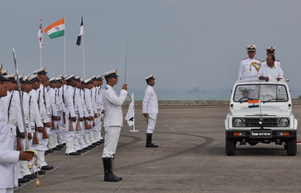
Ezhimala, a hill reaching a height of , is located near Payyanur, in Kannur district of Kerala, south India. It is a part of a conspicuous and isolated cluster of hills, forming a promontory, north of Kannur (Cannanore). The Indian Naval Academy at Ezhimala is the Asia's largest, and the world's third-largest, naval academy. As the former capital of the ancient Kolathunadu Kingdom of the Mushikas, Ezhimala is considered to be an important historical site. A flourishing seaport and center of trade around the beginning of the Common Era, it was also one of the major battlefields of the Chola- Chera Wars, in the 11th century. It is believed by some that Buddha had visited Ezhimala. The Kolathunadu (Kannur) Kingdom at the peak of its power, reportedly extended from Netravati River (Mangalore) in the north to Korapuzha (Kozhikode) in the south with Arabian Sea on the west and Kodagu hills on the eastern boundary, also including the isolated islands of Lakshadweep in the Arabian Sea ... [...More Info...] [...Related Items...] OR: [Wikipedia] [Google] [Baidu] |
Arabian Sea
The Arabian Sea ( ar, اَلْبَحرْ ٱلْعَرَبِيُّ, Al-Bahr al-ˁArabī) is a region of the northern Indian Ocean bounded on the north by Pakistan, Iran and the Gulf of Oman, on the west by the Gulf of Aden, Guardafui Channel and the Arabian Peninsula, on the southeast by the Laccadive Sea and the Maldives, on the southwest by Somalia, and on the east by India. Its total area is 3,862,000 km2 (1,491,000 sq mi) and its maximum depth is 4,652 meters (15,262 ft). The Gulf of Aden in the west connects the Arabian Sea to the Red Sea through the strait of Bab-el-Mandeb, and the Gulf of Oman is in the northwest, connecting it to the Persian Gulf. Name The sea is named after Arabia, the historic name of the region to the west of the sea. The Arabian Sea's name in Arabic is ; in Persian it is دریای عرب; in Urdu it is بحیرہ عرب; in Hindi it is अरब सागर; in Gujarati it is અરબી સમુદ્ર; in Marathi it is ... [...More Info...] [...Related Items...] OR: [Wikipedia] [Google] [Baidu] |
Madayi
Madayi (a.k.a. Madai). is a Census Town and Grama panchayat in Kannur district of Kerala state, India. Bhagavathy shrine, Madayi Kavu (Thiruvar Kadu Bhagavathi Temple) where devotees worship Bhadrakali, is located here. The Goddess is one of the family deity of the Chirakkal Royal family, and the temple is known for the ''Koyikalasham'' (Offering of chicken). The temple was one of the few to survive desecration by the armies of Tippu Sultan, which devotees attribute to the grace of the Goddess. The Kolathiri Rajahs were the administrators of the temple, however recently the administration was transferred to the Malabar Devaswom Board. Nearby is the Vadukunnu Temple dedicated to Shiva. The temple was razed by followers of Tippu Sultan in the 18th century, but the temple has been rebuilt and is a vibrant centre of religion in the region. Madayi is also well known for the '' Malik Ibn Dinar mosque''(a.k.a. Madayi Palli). This ancient mosque is believed to have been original ... [...More Info...] [...Related Items...] OR: [Wikipedia] [Google] [Baidu] |
Palode
Palode is a town in Thiruvananthapuram district in the Indian state of Kerala. Palode town is from Thiruvananthapuram city and from Nedumangad municipality.There is a Helipad in palode. Palode is surrounded by Western Ghats. Jawaharlal Nehru Tropical Botanic Garden and Research Institute is situated near Palode. Mankayam Ecotourism near Brimore is away. Brimore has tea estate and plantations make Palode a gateway for tourism destination.Thenmala is from Palode and Ponmudi hills is 35 km. Palode is town in Thiruvananthapuram-Thenmala -Shenkottai State Highway 2 (Kerala). Tenkasi is from Palode. Palode is a town located in Nedumangad Taluk of Thiruvananthapuram district in Kerala. Place of Interest and Tourism near Palode are Jawaharlal Nehru Tropical Botanical Garden, Mankayam Ecotourism, Brimore Tourism, Lower Meenmutty Hydel Tourism Centre Nanniyode Demographics Palode is a town located in Nedumangad Taluk of Thiruvananthapuram district in Kerala. Palode had ... [...More Info...] [...Related Items...] OR: [Wikipedia] [Google] [Baidu] |
Thekkumkara
Thekkumkara is a village in Thrissur district in the state of Kerala, India. Demographics India census, Thekkumkara had a population of 14236 with 6697 males and 7539 females. References Tourist Attraction in Tekkumkara 1) Machad Mamangam 2) Vazhani Dam Vazhani Dam is a clay dam built across the Wadakkancherry river near Wadakkancherry in Thrissur district of Kerala. The water is used for irrigation and drinking purposes. The dam has a four-acre garden and the construction was completed in 196 ... 3) Pattathippara Falls 4) Cheppara hillstation 5) St Antony's Church Machad 6) Poomala Dam Villages in Mukundapuram Taluk {{Thrissur-geo-stub ... [...More Info...] [...Related Items...] OR: [Wikipedia] [Google] [Baidu] |
Kuppam River
The Kuppam River is a river mainly within the Kannur district of the Indian state of Kerala, although a smaller section of the river is in Karnataka. Course The Kuppam River originates in the Brahmagiri Wildlife Sanctuary of Kodagu district, near the Kerala-Karnataka border. From its source it flows west through Taliparamba and Kannur taluks, passing Therandy, Cheriyoor, Pachheni, Iringal, Kuppam, Pattuvam, Payangadi, and Matool. It flows into the Lakshadweep Sea just north of Azhikkal, after meeting the Valapattanam River. The river is about long, but it is only navigable for . The Kuppam flows for in Karnataka, and for in Kerala. The river's largest tributary, which joins the Kuppam southwest of Pattuvam, is the Kuttikol river, which is long. Other tributaries include the Chiriyathodu, Mukuttathodu, Alakuttathodu, and Pakkattupoya rivers.https://censusindia.gov.in/2011census/dchb/3202_PART_B_KANNUR.pdf Basin The drainage basin of the Kuppam River covers of lan ... [...More Info...] [...Related Items...] OR: [Wikipedia] [Google] [Baidu] |
Kavvayi Backwaters
Kavvayi Backwaters located near Payyanur is the third largest backwater in Kerala and the largest one in north Kerala. The Kavvayi Kayal (backwaters) is dotted with several small and large islands. Valiyaparamba island is the largest among them and stretches over 16 km2.. Islands of Kavvayi backwaters * Kavvayi * Valiyaparamba * Padannakkadappuram * Vadakkekkadu * Kokkal * Edayilakkad * Madakkal * Kannuveed * Kavvayikkadappuram * Udumbanthala * Kochen * Vadakkumbad Geography The Kavvayi Backwater, located near Payyannur, is the third largest backwaters in Kerala and the largest one in north Kerala. Locally called as Kavvayi Kayal or the backwaters of Kavvayi, this lesser known lake of northern Kerala is fed by five rivers viz. River Kavvayi and its tributary streams Kankol, Vannathichal, Kuppithodu, and Kuniyan. Kavvayi backwaters is named after the Kavvayi Islands close to Payyannur. Kavvayi used to be an inland port and a major administrative center during the past ... [...More Info...] [...Related Items...] OR: [Wikipedia] [Google] [Baidu] |


