|
Paradies (Constance)
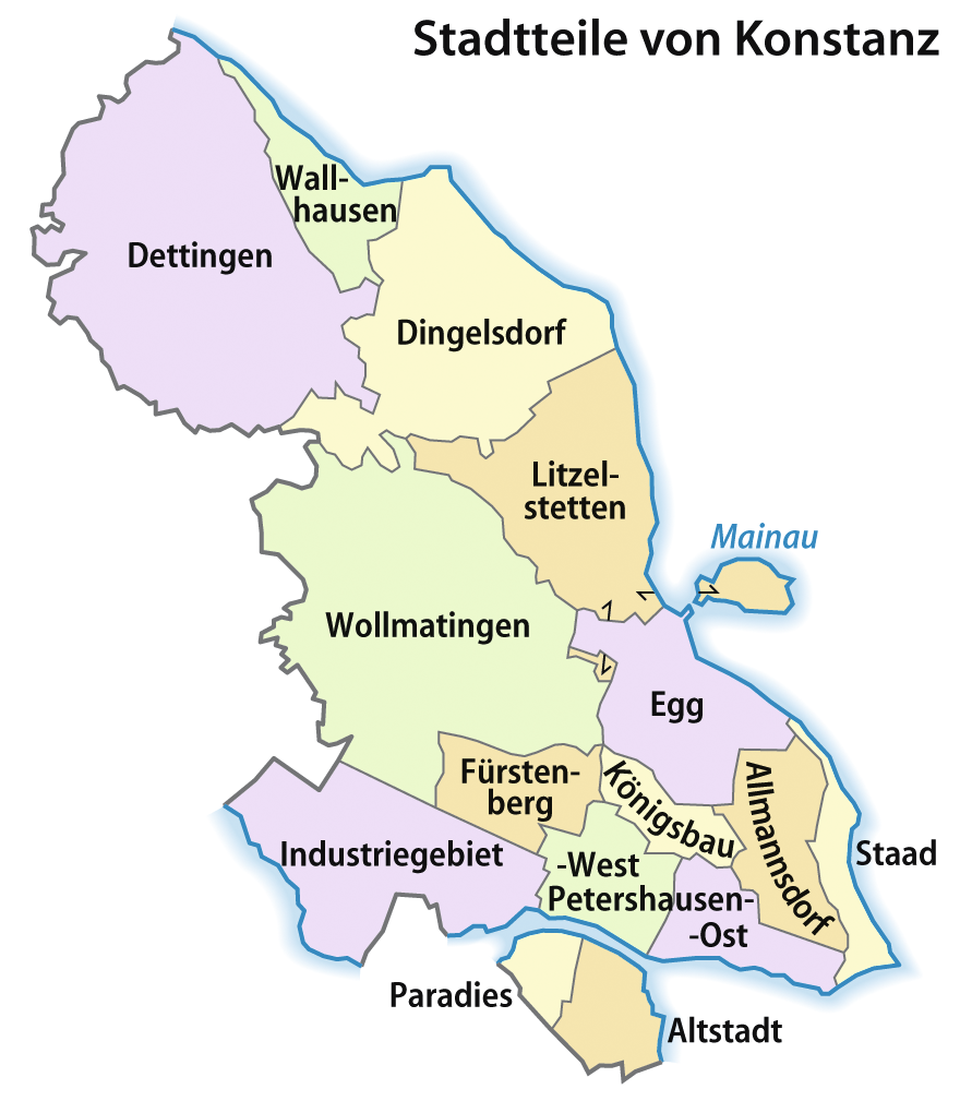
Paradies (literally: "paradise") is a former village, now a quarter of Konstanz, Germany. The district is located west of the Old Town on the southern shore of the Seerhein; with an area of about 63.2 hectare (, to be exact) and 6176 inhabitants (2007 census). In the Late Middle Ages, it was a fishing and farming village called ''Eggehusen''. Its original centre was the St Leonard's Chapel erected in the 14th century at the site of a former Poor Clares monastery with the name ''claustrum Paradysi apud Constantiam'' founded in 1186. In 1253 the nuns left their convent on the outskirts of Konstanz and moved to Schlatt near Schaffhausen; while the name ''Paradies'' stuck. The chapel was rebuilt in 1921, it today is consecrated to St Martin. In 1610, about 300 people were living in Paradies. The farmers in Paradies supplied the inhabitants of the city from their fields on the open space between the current federal road B 33 (Europe Street) and the city walls. Paradies th ... [...More Info...] [...Related Items...] OR: [Wikipedia] [Google] [Baidu] |
Konstanz Stadtteile Mehrfarbig
Konstanz (, , locally: ; also written as Constance in English) is a university city with approximately 83,000 inhabitants located at the western end of Lake Constance in the south of Germany. The city houses the University of Konstanz and was the residence of the Roman Catholic Diocese of Konstanz for more than 1,200 years. Location The city is located in the state of Baden-Württemberg and situated at the banks of Lake Constance (''Bodensee'' in German). The river Rhine, which starts in the Swiss Alps, passes through Lake Constance and leaves it, considerably larger, by flowing under a bridge connecting the two parts of the city. North of the river lies the larger part of the city with residential areas, industrial estates, and the University of Konstanz; while south of the river is the old town, which houses the administrative centre and shopping facilities in addition to the ''Hochschule'' or the ''University of Applied Sciences''. Car ferries provide access across Lake Cons ... [...More Info...] [...Related Items...] OR: [Wikipedia] [Google] [Baidu] |
Konstanz
Konstanz (, , locally: ; also written as Constance in English) is a university city with approximately 83,000 inhabitants located at the western end of Lake Constance in the south of Germany. The city houses the University of Konstanz and was the residence of the Roman Catholic Diocese of Konstanz for more than 1,200 years. Location The city is located in the state of Baden-Württemberg and situated at the banks of Lake Constance (''Bodensee'' in German). The river Rhine, which starts in the Swiss Alps, passes through Lake Constance and leaves it, considerably larger, by flowing under a bridge connecting the two parts of the city. North of the river lies the larger part of the city with residential areas, industrial estates, and the University of Konstanz; while south of the river is the old town, which houses the administrative centre and shopping facilities in addition to the ''Hochschule'' or the ''University of Applied Sciences''. Car ferries provide access across Lake C ... [...More Info...] [...Related Items...] OR: [Wikipedia] [Google] [Baidu] |
Germany
Germany, officially the Federal Republic of Germany (FRG),, is a country in Central Europe. It is the most populous member state of the European Union. Germany lies between the Baltic and North Sea to the north and the Alps to the south. Its 16 constituent states have a total population of over 84 million in an area of . It borders Denmark to the north, Poland and Czechia to the east, Austria and Switzerland to the south, and France, Luxembourg, Belgium, and the Netherlands to the west. The nation's capital and most populous city is Berlin and its main financial centre is Frankfurt; the largest urban area is the Ruhr. Settlement in what is now Germany began in the Lower Paleolithic, with various tribes inhabiting it from the Neolithic onward, chiefly the Celts. Various Germanic tribes have inhabited the northern parts of modern Germany since classical antiquity. A region named Germania was documented before AD 100. In 962, the Kingdom of Germany formed the ... [...More Info...] [...Related Items...] OR: [Wikipedia] [Google] [Baidu] |
Seerhein
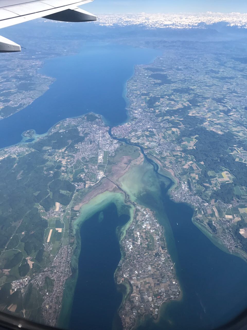
The Seerhein ("Lake Rhine") is a river about four kilometres long, in the basin of Lake Constance. It is the outflow of the Upper Lake Constance and the main tributary of the Lower Lake Constance. The water level of the lower lake is about 30 cm below the level of the Upper Lake. It is considered part of the Rhine, which flows into Lake Constance as the Alpine Rhine and flows out of the Lake as the High Rhine. The Seerhein arose after the last ice age (the Würm glaciation, about 9650 BCE). Some time after this period, the water level of Lake Constance gradually dropped by about ten metres and the shallow parts fell dry. Some parts of the Seerhein still have a character a bit like a lake. The border between Germany and Switzerland runs down the center of the lower stretch of the river; the German city of Constance, the largest community on the river, is situated on both sides of the upper part. Location General The Seerhein extends over a length of 4.3 km ... [...More Info...] [...Related Items...] OR: [Wikipedia] [Google] [Baidu] |
Hectare
The hectare (; SI symbol: ha) is a non-SI metric unit of area equal to a square with 100- metre sides (1 hm2), or 10,000 m2, and is primarily used in the measurement of land. There are 100 hectares in one square kilometre. An acre is about and one hectare contains about . In 1795, when the metric system was introduced, the ''are'' was defined as 100 square metres, or one square decametre, and the hectare (" hecto-" + "are") was thus 100 ''ares'' or km2 (10,000 square metres). When the metric system was further rationalised in 1960, resulting in the International System of Units (), the ''are'' was not included as a recognised unit. The hectare, however, remains as a non-SI unit accepted for use with the SI and whose use is "expected to continue indefinitely". Though the dekare/decare daa (1,000 m2) and are (100 m2) are not officially "accepted for use", they are still used in some contexts. Description The hectare (), although not a unit of SI, ... [...More Info...] [...Related Items...] OR: [Wikipedia] [Google] [Baidu] |
Late Middle Ages
The Late Middle Ages or Late Medieval Period was the period of European history lasting from AD 1300 to 1500. The Late Middle Ages followed the High Middle Ages and preceded the onset of the early modern period (and in much of Europe, the Renaissance). Around 1300, centuries of prosperity and growth in Europe came to a halt. A series of famines and plagues, including the Great Famine of 1315–1317 and the Black Death, reduced the population to around half of what it had been before the calamities. Along with depopulation came social unrest and endemic warfare. France and England experienced serious peasant uprisings, such as the Jacquerie and the Peasants' Revolt, as well as over a century of intermittent conflict, the Hundred Years' War. To add to the many problems of the period, the unity of the Catholic Church was temporarily shattered by the Western Schism. Collectively, those events are sometimes called the Crisis of the Late Middle Ages. Despite the crises, the 1 ... [...More Info...] [...Related Items...] OR: [Wikipedia] [Google] [Baidu] |
Poor Clares
The Poor Clares, officially the Order of Saint Clare ( la, Ordo sanctae Clarae) – originally referred to as the Order of Poor Ladies, and later the Clarisses, the Minoresses, the Franciscan Clarist Order, and the Second Order of Saint Francis – are members of a contemplative Order of nuns in the Catholic Church. The Poor Clares were the second Franciscan branch of the order to be established. Founded by Clare of Assisi and Francis of Assisi on Palm Sunday in the year 1212, they were organized after the Order of Friars Minor (the ''first Order''), and before the Third Order of Saint Francis for the laity. As of 2011, there were over 20,000 Poor Clare nuns in over 75 countries throughout the world. They follow several different observances and are organized into federations. The Poor Clares follow the ''Rule of St. Clare'', which was approved by Pope Innocent IV on the day before Clare's death in 1253. The main branch of the Order (O.S.C.) follows the observance of Pope ... [...More Info...] [...Related Items...] OR: [Wikipedia] [Google] [Baidu] |
Schlatt Bei Diessenhofen
Schlatt (or sometimes ''Schlatt TG'' in order to distinguish it from others) is a municipality in Frauenfeld District in the canton of Thurgau in Switzerland. History Schlatt is first mentioned in 858 as ''Slate''. In the Middle Ages, the House of Kyburg (subsequently House of Habsburg) bailiwick of Diessenhofen had jurisdiction over Schlatt. In the 15th century, the town of Diessenhofen became mostly independent and took over the jurisdiction of Schlatt. It exercised this right until 1798. The major landowner before 858 was the Abbey of St. Gall, then after 858 Rheinau Abbey acquired the land. In the 13th century, the monastery of St. Katharinental, along with others, held most of the land in the village. The St Nicholas Chapel, which existed from 1316 until 1812, belonged to Stammheim parish (today Oberstammheim and Unterstammheim). Though the Protestant Reformation of 1529 created an independent parish of Schlatt, it declined until it was abolished in 1769. In the late 16th c ... [...More Info...] [...Related Items...] OR: [Wikipedia] [Google] [Baidu] |
Schaffhausen
Schaffhausen (; gsw, Schafuuse; french: Schaffhouse; it, Sciaffusa; rm, Schaffusa; en, Shaffhouse) is a town with historic roots, a municipality in northern Switzerland, and the capital of the canton of the same name; it has an estimated population of 36,000 It is located right next to the shore of the High Rhine; it is one of four Swiss towns located on the northern side of the Rhine, along with , the historic , and . The old town has many fine Renaissance era buildings decorated with exterior frescos and sculpture, as well as the old canton fortress, the ''Munot''. Schaffhausen is also a railway junction of Swiss and German rail networks. One of the lines connects the town with the nearby Rhine Falls in , Europe's largest waterfall, a tourist attraction. The official language of Schaffhausen is (the Swiss variety of Standard) German, but the main spoken language is the local variant of the Alemannic Swiss German dialect. Name The town is first mentioned in ... [...More Info...] [...Related Items...] OR: [Wikipedia] [Google] [Baidu] |
Konstanz Paradies Karte 1847
Konstanz (, , locally: ; also written as Constance in English) is a university city with approximately 83,000 inhabitants located at the western end of Lake Constance in the south of Germany. The city houses the University of Konstanz and was the residence of the Roman Catholic Diocese of Konstanz for more than 1,200 years. Location The city is located in the state of Baden-Württemberg and situated at the banks of Lake Constance (''Bodensee'' in German). The river Rhine, which starts in the Swiss Alps, passes through Lake Constance and leaves it, considerably larger, by flowing under a bridge connecting the two parts of the city. North of the river lies the larger part of the city with residential areas, industrial estates, and the University of Konstanz; while south of the river is the old town, which houses the administrative centre and shopping facilities in addition to the ''Hochschule'' or the ''University of Applied Sciences''. Car ferries provide access across Lake Cons ... [...More Info...] [...Related Items...] OR: [Wikipedia] [Google] [Baidu] |
Tägermoos
The Tägermoos is an area of 1.54 km2 (380 acres) in Thurgau, Switzerland, wedged between the outskirts of the German city of Constance and the core village of the Swiss municipality of Tägerwilen. It lies on the south bank of the Seerhein. In the east, it borders the district Paradies of Constance. In the south-east, it borders the district Emmishofen of the municipality of Kreuzlingen. The remarkable status of Tägermoos was fixed in 1831 by a treaty which is still in force today. Under this treaty, the area is part of Switzerland at the state level and part of the Swiss municipality of Tägerwilen. However, certain administrative tasks are exercised by the German city of Constance, in accordance with Thurgau municipal law. Other tasks are exercised by the authorities of Tägerwilen. In particular, land survey is the responsibility of Constance, making Tägermoos a of the city of Constance. The City of Constance legally owns about two-thirds of the land; the ... [...More Info...] [...Related Items...] OR: [Wikipedia] [Google] [Baidu] |
Switzerland
; rm, citad federala, links=no). Swiss law does not designate a ''capital'' as such, but the federal parliament and government are installed in Bern, while other federal institutions, such as the federal courts, are in other cities (Bellinzona, Lausanne, Lucerne, Neuchâtel, St. Gallen a.o.). , coordinates = , largest_city = Zurich , official_languages = , englishmotto = "One for all, all for one" , religion_year = 2022 , religion_ref = , religion = , demonym = , german: link=no, Schweizer/Schweizerin, french: link=no, Suisse/Suissesse, it, svizzero/svizzera or , rm, Svizzer/Svizra , government_type = Federal assembly-independent directorial republic , leader_title1 = Federal Council , leader_name1 = , leader_title2 = , leader_name2 = Viktor Rossi , legislature = Federal Assembly , upper_house = Counci ... [...More Info...] [...Related Items...] OR: [Wikipedia] [Google] [Baidu] |


