|
Panavally
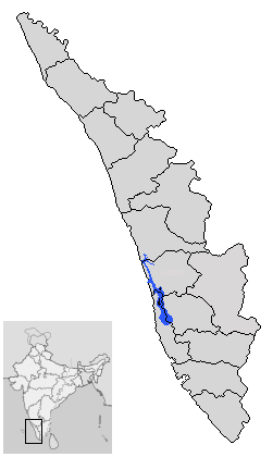
Panavally is a village in India that is north part of Cherthala taluk and Alappuzha district in Kerala state. It is about 25 minutes(19km) drive from Kochi city. Geography Panavally is a village on the northern end of Alappuzha district. It spans from Arookutty on the northern side to Poochackal on the southern side Arookutty was the northern frontier of Travencore which separated it with old Kochi. The old customs house and the summer palace of Travencore King, which is overlooking the backwaters are still there. Different branches of the backwaters of Vembanad surround the village. Geographically, this area is part of the seashore sector of Kerala. The soil and other eco system show, like many regions of Kerala, that this part of the land emerged from the sea, few centuries ago. The sand in the southern part of this village is a great source of special silica sand, containing high concentration of pure silica. This was being used in many industries, in particular in brick (wh ... [...More Info...] [...Related Items...] OR: [Wikipedia] [Google] [Baidu] |
Poochakkal
Poochakkal is part of a small island consisting Arookutty, Panavally, Thycattusserry and Pallippuram Panchayaths close to the Kerala Backwaters in Kerala, India. Until the 2006 Kerala Assembly Elections, Poochakkal was part of the Cherthala LAC. After delimitation from the 2011 elections, it became a part of Aroor LAC. Location Poochakkal is located about 2 miles (3.22 km) from Vaduthala(Arookutty), 8 miles (14 km) from Cherthala, about 5 miles (8 km) from Vaikom, 12 miles (20 km) from Vytilla Hub and 15 miles (25 km) from Ernakulam. Economy The economy was based on a water transportation system. Its water canal connects the eastern and western parts of Vembanadu Lake. Now it is directly connected to NH47 at two places by new road bridges at Aroor and Thuravoor. Also new bridge is under construction connecting to Vaikom. Notable people * Saiju Kurup Saiju Kurup (born 12 March 1979) is an Indian actor who works predominantly in Malayalam cinem ... [...More Info...] [...Related Items...] OR: [Wikipedia] [Google] [Baidu] |
Aroor (State Assembly Constituency)
Aroor State assembly constituency is one of the 140 state legislative assembly constituencies in Kerala state in southern India. It is also one of the 7 state legislative assembly constituencies included in the Alappuzha Lok Sabha constituency. As of the 2021 assembly elections, the current MLA is Daleema Jojo of CPI(M). Local self governed segments Aroor Niyamasabha constituency is composed of the following local self governed segments: Members of Legislative Assembly The following list contains all members of Kerala legislative assembly who have represented Aroor Niyamasabha Constituency during the period of various assemblies: Key Election results Percentage change (±%) denotes the change in the number of votes from the immediate previous election. Niyamasabha by-election 2019 Due to the election of the sitting MLA, A. M. Ariff as the MP from Alappuzha (Lok Sabha constituency), Aroor Niyamasabha Constituency went to bypolls in 2019. There were 1,91,898 ... [...More Info...] [...Related Items...] OR: [Wikipedia] [Google] [Baidu] |
States And Territories Of India
India is a federal union comprising 28 states and 8 union territories, with a total of 36 entities. The states and union territories are further subdivided into districts and smaller administrative divisions. History Pre-independence The Indian subcontinent has been ruled by many different ethnic groups throughout its history, each instituting their own policies of administrative division in the region. The British Raj mostly retained the administrative structure of the preceding Mughal Empire. India was divided into provinces (also called Presidencies), directly governed by the British, and princely states, which were nominally controlled by a local prince or raja loyal to the British Empire, which held ''de facto'' sovereignty ( suzerainty) over the princely states. 1947–1950 Between 1947 and 1950 the territories of the princely states were politically integrated into the Indian union. Most were merged into existing provinces; others were organised into ... [...More Info...] [...Related Items...] OR: [Wikipedia] [Google] [Baidu] |
Aroor
Aroor is a census town at the northern end of Alappuzha district and the southern suburb of the city of Kochi in the state of Kerala, India. It is a seafood related industrial area of Alleppey district, and acts as the Southern entry point into Kochi city. Aroor is at present a municipality located just south of Kochi Urban Agglomeration. It is expected to be a part of Kochi UA in the upcoming census, since its urban growth is now continuous with Kochi city. Location Aroor is the northernmost tip of Alappuzha district and lies on the National Highway 66 at the south end of Kochi Bypass. It is around 14km south of Ernakulam, the city centre of Kochi, which is the largest city in Kerala widely known as its commercial hub. Aroor is linked to the nearby land Kumbalam island in Kochi, through a bridge. The Aroor-Kumbalam Bridge is the second-longest bridge (now the bridge is doubled with four-lane traffic) in Kerala, spanning about 993 m. It links Aroor with Kochi city at Kum ... [...More Info...] [...Related Items...] OR: [Wikipedia] [Google] [Baidu] |
Arookutty
Arookutty is a census town in Alappuzha district in the state of Kerala, India. Demographics India census, Arookutty had a population of 17,387. Males constitute 50% of the population and females 50%. Arookutty has an average literacy rate of 80%, higher than the national average of 59.5%; with 53% of the males and 47% of females literate. 11% of the population is under 6 years of age. It is the northern tip of a beautiful peninsula by the name Karappuram surrounded by vembanad lake in three sides. Arookutty My Village, a documentary on the history of Arookutty, was published in 2012. It is directed by Biju Chettukad, a history teacher at Mattathil Bhagom School Location The nearest major railway station is Ernakulam Junction and the nearest airport is Cochin International Airport. Cherthala - Arookutty road runs parallel to National Highway 47 (India), National Highway 47. Nearest Railway Station Aroor Railway Station. References Cities and towns in Alappuzha d ... [...More Info...] [...Related Items...] OR: [Wikipedia] [Google] [Baidu] |
Vembanad
Vembanad is the longest lake in India, as well as the largest lake in the state of Kerala. The lake has an area of 230 square kilometers and a maximum length of 96.5 km. Spanning several districts in the state of Kerala, it is known as Vembanadu Lake in Kottayam, Vaikom, Changanassery, Punnamada Lake in Alappuzha, Punnappra, Kuttanadu and Kochi Lake in Kochi. Several groups of small islands including Vypin, Mulavukad, Maradu, Udayamperoor, Vallarpadam, Willingdon Island are located in the Kochi Lake portion. Kochi Port is built around the Willingdon Island and the Vallarpadam island. Kuttanad, also known as ''The Rice Bowl of Kerala'', has the lowest altitude in India, and is also one of the few places in world where cultivation takes place below sea level. Kuttanad lies on the southern portion of Vembanad. The Nehru Trophy Boat Race is conducted in a portion of the lake. High levels of pollution have been noticed at certain hotspots of the Vembanad backwaters. The Gov ... [...More Info...] [...Related Items...] OR: [Wikipedia] [Google] [Baidu] |
Alappuzha
Alappuzha or Alleppey () is the administrative headquarters of Alappuzha district in States and territories of India, state of Kerala, India. The Kerala Backwaters, Backwaters of Alappuzha are one of the most popular tourist attractions in India which attracts millions of domestic and international tourists. Alleppey is a city and a municipality in Kerala with an urban population of 174,164 and ranks third among the districts in literacy rate in the state. In 2016, the Centre for Science and Environment rated Alappuzha as the cleanest town in India. Alappuzha is considered to be the oldest planned city in this region and the lighthouse built on the coast of the city is the first of its kind along the Laccadive Sea coast. The city is 55 km from Kochi and 155 km north of Thiruvananthapuram district, Thiruvananthapuram. A town with canals, Kerala Backwaters, backwaters, Alappuzha Beach, beaches, and lagoons, Alappuzha was described by George Curzon, 1st Marquess Curzon o ... [...More Info...] [...Related Items...] OR: [Wikipedia] [Google] [Baidu] |
Cherthala
Cherthala, , (formerly Shertalai, Shertallai or Shertallay) is a Municipal town and a Taluk located at National highway 66 in the district of Alappuzha, in the state of Kerala, India. Cherthala is the satellite town and industrial hub of Alappuzha. In the local administration, Cherthala is a municipality, while in the state administrative structure Cherthala is a taluk and its headquarters are in the district of Alappuzha. Etymology According to local legend, Vilwamangalam Swamiyar, the Kerala Hindu saint, while travelling through Cherthala, found an idol of the Devi with its head immersed in a muddy pond. The swami understood the divinity of the idol, took it out of the mud, cleaned it and consecrated it in a temple near the pond. Thus the place is believed to have gotten its name as ''cher'' meaning "mud" and ''thala'' meaning "head" in Malayalam. The deity of the temple has the name ''Cherthala Karthiyayani''. Climate Demographics According to 2011 census report, Chert ... [...More Info...] [...Related Items...] OR: [Wikipedia] [Google] [Baidu] |
Niyamasabha
The Kerala Legislative Assembly, popularly known as the Kerala Niyamasabha, is the State Assembly of Kerala, one of the 28 states in India. The Assembly is formed by 140 elected representatives. Each elected member represents one of the 140 constituencies within the borders of Kerala and is referred to as Member of the Legislative Assembly (MLA). The present Kerala Legislative Assembly consists of 140 elected members. History In 1956, the State of Kerala was formed on linguistic basis, merging Cochin, Malabar, and Travancore regions, and the Kasaragod region of South Canara. The first assembly election in Kerala state was held in February–March 1957. The first ''Kerala Legislative Assembly'' was formed on 5 April 1957. The Assembly had 127 members including a nominated member. The current delimitation committee of 2010 reaffirmed the total number of seats at 140. Niyamasabha Complex The State Assembly is known as Niyamasabha and is housed in New Legislature Complex. ... [...More Info...] [...Related Items...] OR: [Wikipedia] [Google] [Baidu] |
Kerala
Kerala ( ; ) is a state on the Malabar Coast of India. It was formed on 1 November 1956, following the passage of the States Reorganisation Act, by combining Malayalam-speaking regions of the erstwhile regions of Cochin, Malabar, South Canara, and Thiruvithamkoor. Spread over , Kerala is the 21st largest Indian state by area. It is bordered by Karnataka to the north and northeast, Tamil Nadu to the east and south, and the Lakshadweep Sea to the west. With 33 million inhabitants as per the 2011 census, Kerala is the 13th-largest Indian state by population. It is divided into 14 districts with the capital being Thiruvananthapuram. Malayalam is the most widely spoken language and is also the official language of the state. The Chera dynasty was the first prominent kingdom based in Kerala. The Ay kingdom in the deep south and the Ezhimala kingdom in the north formed the other kingdoms in the early years of the Common Era (CE). The region had been a prominent spic ... [...More Info...] [...Related Items...] OR: [Wikipedia] [Google] [Baidu] |
Lok Sabha
The Lok Sabha, constitutionally the House of the People, is the lower house of India's bicameral Parliament, with the upper house being the Rajya Sabha. Members of the Lok Sabha are elected by an adult universal suffrage and a first-past-the-post system to represent their respective constituencies, and they hold their seats for five years or until the body is dissolved by the President on the advice of the council of ministers. The house meets in the Lok Sabha Chambers of the Sansad Bhavan, New Delhi. The maximum membership of the House allotted by the Constitution of India is 552 (Initially, in 1950, it was 500). Currently, the house has 543 seats which are made up by the election of up to 543 elected members and at a maximum. Between 1952 and 2020, 2 additional members of the Anglo-Indian community were also nominated by the President of India on the advice of Government of India, which was abolished in January 2020 by the 104th Constitutional Amendment Act, 2019. The ... [...More Info...] [...Related Items...] OR: [Wikipedia] [Google] [Baidu] |


