|
Paama
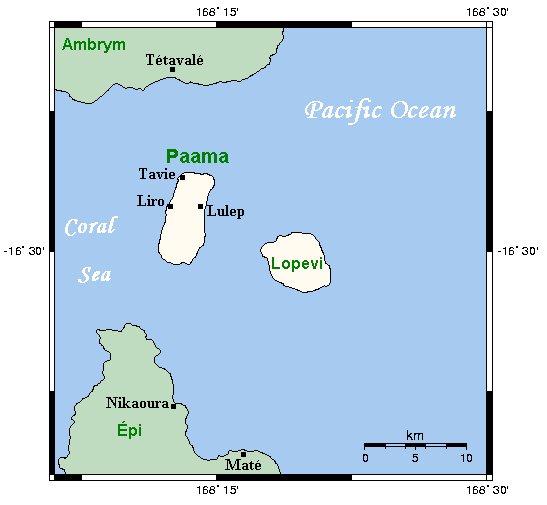
Paama (Paama language: VoumCrowley, Terry. (1982). ''The Paamese Language of Vanuatu. Pacific Linguistics, Series B – No. 87''. Canberra: ANU Printing Services.) is a small island in Malampa Province, Vanuatu. The island is about 8 km from north to south and only 5 km or so at its widest point. The island is dominated by hills, rising to a height of around 550 m in the north. Paama lies a short distance south of Ambrym, a little further east of Malakula, about 7 km west of the large active volcano Lopevi (Ulvae, in the vernacular (see Crowley 1982), and a short distance north of the island of Epi (island), Epi. During daylight, all of Paama's neighbouring islands are clearly visible from various locations on the island. Indeed, on a clear night the red glow of Ambrym's twin volcanos can be seen clearly from the black sand beach at Liro. The now uninhabited island of Lopevi dominates the view east from the village of Lulep, on the northeast coast of the is ... [...More Info...] [...Related Items...] OR: [Wikipedia] [Google] [Baidu] |
Paama Language
Paamese, or Paama, is the language of the island of Paama in Northern Vanuatu. There is no indigenous term for the language; however linguists have adopted the term ''Paamese'' to refer to it. Both a grammar and a dictionary of Paamese have been produced by Terry Crowley (linguist), Terry Crowley. Classification Paamese is an Austronesian language of Vanuatu. It is most closely related to Southeast Ambrym language, the language of Southeastern Ambrym. The two languages, while sharing 60-70% of the lexical cognate, are not mutually intelligible. Geographic distribution Paama itself is a small island in the Malampa Province. The island is no more than wide and long. There is no running water on the island except after heavy storms. In the 1999 census in Vanuatu, 7,000 people identified as Paamese, with 2,000 on the island itself and others through the urban hubs of Vanuatu, particularly Port Vila. Dialects/Varieties Paamese spoken in different parts of the island (and then th ... [...More Info...] [...Related Items...] OR: [Wikipedia] [Google] [Baidu] |
East Vanuatu Language
The Central Vanuatu languages form a linkage of Southern Oceanic languages spoken in central Vanuatu. Languages Clark (2009) Clark (2009) provides the following classification of the Central Vanuatu languages, divided into geographic areas. Outlier (aberrant) languages identified by Clark (2009) are in ''italics''. Clark's Central Vanuatu branch is wider in scope, including not only the Shepherd–Efate languages, but also the Malakula and Ambrym–Paama–Epi languages. *Central Vanuatu **Malakula languages *** Northeast Malakula (Uripiv), Vao language, Vao, Vovo language, Vovo; ''Mpotovoro language, Mpotovoro'' ***''Dirak language, Dirak'', ''Malua Bay language, Malua Bay'' ***''V'ënen Taut language, V’ënen Taut'', ''Tape language, Tape'' ***''Larevat language, Larevat'', ''Neve'ei language, Neve’ei'', ''Naman language, Naman'' ***''Navava language, Navava'', ''Nevwervwer language, Nevwervwer'' ***Unua language, Unua-Pangkumu language, Pangkumu ***Banam Bay language, Banam ... [...More Info...] [...Related Items...] OR: [Wikipedia] [Google] [Baidu] |
Paama Airport
Paama Airport is an airport on Paama island, in the Malampa Province of Vanuatu Vanuatu ( or ; ), officially the Republic of Vanuatu (french: link=no, République de Vanuatu; bi, Ripablik blong Vanuatu), is an island country located in the South Pacific Ocean. The archipelago, which is of volcanic origin, is east of no .... Airlines and destinations References Airports in Vanuatu Malampa Province {{Vanuatu-geo-stub ... [...More Info...] [...Related Items...] OR: [Wikipedia] [Google] [Baidu] |
Provinces Of Vanuatu
Vanuatu has been divided into six provinces since 1994. The names in English of all provinces are derived from the initial letters of their constituent islands: Municipalities The provinces are in turn divided into municipalities headed by a council and a mayor elected from among the members of the council. In the Tafea Province for example are the following municipalities (council areas): *North Erromango *South Erromango *North Tanna *West Tanna *Middle Bush Tanna *Whitesands *South West Tanna *South Tanna The islands of Aniwa, Futuna and Aneityum appear to consist of one municipality each. Island regions (historical) From 1985 to 1994 it was divided into eleven island regions: Districts (historical) During the Condominium era, specifically from 1968 to 1984 the group was divided into four administrative districts: Districts (1950) In the 1950s, districts appeared to denote the finest administrative level, finer than the current municipalities or council are ... [...More Info...] [...Related Items...] OR: [Wikipedia] [Google] [Baidu] |
Southeast Ambrym Language
Southeast Ambrym, ''Vatlongos'', or ''Taveak'', is a language of Ambrym Island, Vanuatu. It is closely related to Paamese. References External links * Paama–Ambrym languages Languages of Vanuatu {{SOceanic-lang-stub ... [...More Info...] [...Related Items...] OR: [Wikipedia] [Google] [Baidu] |
Lopevi
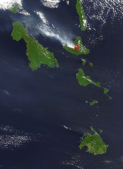
Lopevi (or Lopévi) is an uninhabited island in Malampa Province, Vanuatu. It lies to the southeast of Ambrym and east of Paama. Geography Lopevi consists of the 7-km-wide cone of the active stratovolcano by the same name. It reaches a peak of 1413 m above sea level, the tallest point in central Vanuatu. It has erupted at least 22 times since 1862. The island was formerly inhabited, but in 1960 the population moved to nearby Paama or Epi (island), Epi because of the recurrent danger. Lopevi is on the New Hebrides Plate, where it lies above the subduction, subducted Australian Plate to the west. Because there are no earthquakes between 50 and 200 km below the Earth's surface, it is thought that the subducted plate has fractured, and does not appear between these depths. References External links John Seach site, with photographs Uninhabited islands of Vanuatu Malampa Province Volcanoes of Vanuatu Holocene stratovolcanoes Active volcanoes {{Vanuatu-geo-stub ... [...More Info...] [...Related Items...] OR: [Wikipedia] [Google] [Baidu] |
Malampa Province
Malampa is one of the six provinces of Vanuatu, located in the center of the country. It consists of three main islands: Malakula, Ambrym and Paama, and takes its name from the first syllable of their names. It includes a number of other islands – the small islands of Uripiv, Norsup, Rano, Wala, Atchin and Vao off the coast of Malakula, and the volcanic island of Lopevi (currently uninhabited). Also included are the Maskelynes Islands and some more small islands along the south coast of Malakula. Population It has a population of 36,722 (2009 census) - Government of Vanuatu people and an area of 2,779 km2. Its capital is |
Malakula
Malakula Island, also spelled Malekula, is the second-largest island in the nation of Vanuatu, formerly the New Hebrides, in Melanesia, a region of the Pacific Ocean. Location Malakula is separated from the islands of Espiritu Santo and Malo by the Bougainville Strait. Lakatoro, the capital of Malampa Province, is situated on Malakula’s northeastern shore and is the largest settlement on the island. Just off the northeastern coast of Malakula, there is a group of islands called the ''Small Islands'', including, in order from north to south: Vao, Atchin, Wala, Rano, Norsup, Uripiv, and Uri. Also off the coast: Tomman Island to the southwest; Akhamb Island to the south; and the Maskelynes Islands to the southeast (including Sakao Island and Uluveo). Malakula has a maximum elevation of 879 m. Its peak is called Mt. Liambele. In 1768, Louis Antoine de Bougainville gave his name to the straits that separate Malakula from Santo. History Malakula was inhabited for centu ... [...More Info...] [...Related Items...] OR: [Wikipedia] [Google] [Baidu] |
Alexander Frater
Alexander Russell Frater (3 January 1937 – 1 January 2020) was a British travel writer and journalist. Described by Miles Kington as 'the funniest man who wrote for ''Punch'' since the war', Frater is best known for his various books and for documentaries he wrote and produced for the BBC and ABC. Early life Frater was born in a small mission hospital in Port Vila, Vanuatu, in the middle of a monsoon. His grandfather and his father were Scottish Presbyterian missionaries in Vanuatu. His grandfather Maurice was based on the island of Paama, which had previously been hostile to all outsiders, from 1900-1939. His father Alec, who became a doctor, established a hospital on the island of Iririki, offshore from Parliament House in Port Vila, training local staff in the treatment of tropical diseases. His mother established and ran two schools in Vanuatu. His father would later teach him how to observe and analyse weather. Frater's family employed the services of a native gardener, M ... [...More Info...] [...Related Items...] OR: [Wikipedia] [Google] [Baidu] |
Islands Of Vanuatu
This is a list of islands of Vanuatu by province, largely from north to south, subdivided by archipelago when appropriate. Vanuatu is usually said to contain 83 islands. Islands *Torba Province **Torres Islands *** Hiw ***Metoma (uninhabited, but formerly inhabited) ***Tegua ***Ngwel (uninhabited) ***Linua *** Lo ***Toga **Banks Islands ***Vet Tagde ***Ureparapara ***Rowa Islands (Reef Islands) **** Enwut (uninhabited) **** Lemeur ***Vanua Lava **** Kwakea ****Leneu ****Nawila ****Ravenga ***Gaua (Santa Maria Island) ***Mota ***Mota Lava (Saddle) ****Ra Island ***Merig ***Mere Lava *Sanma Province **Espiritu Santo *** Dany Island ***Araki Island ***Elephant Island *** Dolphin Island *** Sakao *** Malohu ***Malparavu ***Maltinerava ***Malvapevu ***Malwepe ***Oyster Island *** Tangoa ***Bokissa *** Lataro **Malo ***Asuleka *** Malotina ***Malokilikili **Aore ** Tutuba ** Mavea ** Lathi *Penama Province **Pentecost Island **Ambae (Aoba) **Maewo *Malampa Province **Malakula ***Akha ... [...More Info...] [...Related Items...] OR: [Wikipedia] [Google] [Baidu] |
Ambrym
Ambrym is a volcanic island in Malampa Province in the archipelago of Vanuatu. Volcanic activity on the island includes lava lakes in two craters near the summit. Etymology Ambrym (also known as ''Ambrin'', ''"ham rim"'' in the Ranon language) was allegedly named by Captain Cook, who is said to have anchored off there in 1774. In fact, his expedition never touched Ambrym. Geography Located near the center of the Vanuatuan archipelago, Ambrym is roughly triangular in shape, about wide. With of surface area, it is the fifth largest island in the country. The summit at the centre of the island is dominated by a desert-like caldera, which covers an area of . With the exception of human settlements, the rest of the island is covered by a dense jungle. Important Bird Area The western part of the island, comprising 17,605 ha of forest, together with gardens around habitation, has been recognised as an Important Bird Area (IBA) by BirdLife International because it supports ... [...More Info...] [...Related Items...] OR: [Wikipedia] [Google] [Baidu] |
Espiritu Santo
Espiritu Santo (, ; ) is the largest island in the nation of Vanuatu, with an area of and a population of around 40,000 according to the 2009 census. Geography The island belongs to the archipelago of the New Hebrides in the Pacific region of Melanesia. It is in the Sanma Province of Vanuatu. The town of Luganville, on Espiritu Santo's southeast coast, is Vanuatu's second-largest settlement and the provincial capital. Roads run north and west from Luganville, but most of the island is far from the limited road network. Around Espiritu Santo lie a number of small islands and islets; among them are: Dany Island, Araki, Elephant Island, Sakao, Lataroa, Lataro, Thion, Malohu, Malwepe, Malvapevu, Malparavu, Maltinerava, Oyster Island, Tangoa, and Bokissa. Vanuatu's highest peak is the 1879 metre (6165 foot) Mount Tabwemasana in west-central Espiritu Santo. History A Spanish expedition of three ships, led by Portuguese explorer Pedro Fernandes de Queirós, lande ... [...More Info...] [...Related Items...] OR: [Wikipedia] [Google] [Baidu] |

%2C_before_1880.jpg)

