|
Onzaga
Onzaga () is a town and municipality in the Santander Department in northeastern Colombia. Onzaga borders in the north San Joaquín, in the east and south the municipalities Soatá, Covarachía, Tipacoque and Tutazá of the department of Boyacá and in the west with Coromoro. Onzaga is south of the department capital Bucaramanga. The topography of Onzaga varies greatly; from to .Official website - accessed 03-05-2016 History The area around Onzaga was inhabited by the and Onzaga was the northernmost village of their Muisca Confederation. To the north and west the[...More Info...] [...Related Items...] OR: [Wikipedia] [Google] [Baidu] |
Muisca Confederation
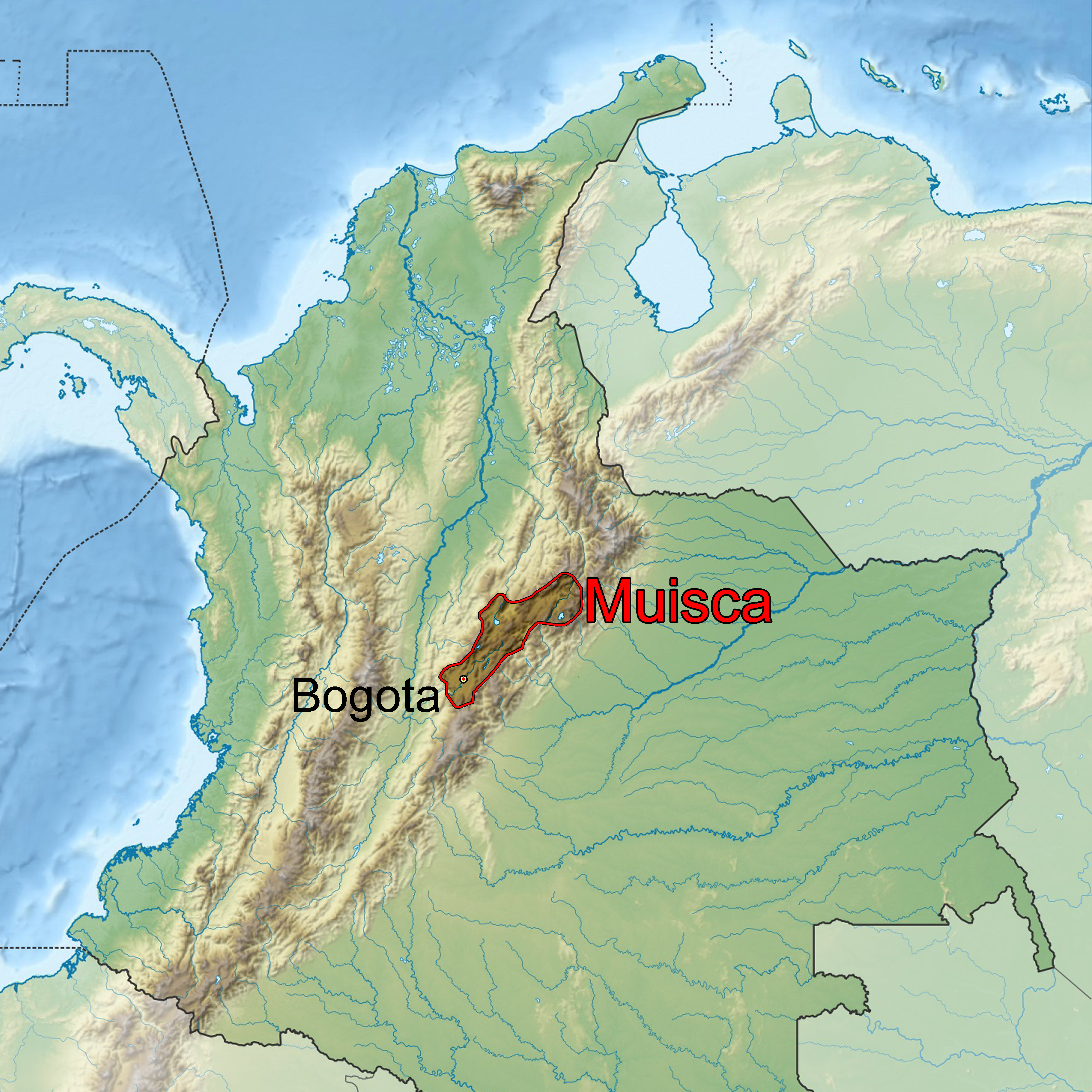
The Muisca Confederation was a loose confederation of different Muisca rulers (''zaques'', ''zipas'', '' iraca'', and ''tundama'') in the central Andean highlands of present-day Colombia before the Spanish conquest of northern South America. The area, presently called Altiplano Cundiboyacense, comprised the current departments of Boyacá, Cundinamarca and minor parts of Santander. According to some Muisca scholars the Muisca Confederation was one of the best-organized confederations of tribes on the South American continent. Modern anthropologists, such as Jorge Gamboa Mendoza, attribute the present-day knowledge about the confederation and its organization more to a reflection by Spanish chroniclers who predominantly wrote about it a century or more after the Muisca were conquered and proposed the idea of a loose collection of different people with slightly different languages and backgrounds.Gamboa Mendoza, 2016 Geography Climate Muisca Confederation In the time ... [...More Info...] [...Related Items...] OR: [Wikipedia] [Google] [Baidu] |
Duitama
Duitama () is a city and municipality in the department of Boyacá. It is the capital of the Tundama Province. Duitama is located northeast of Bogotá, the capital city of Colombia and northeast of Tunja, the capital Boyacá. Duitama has existed since pre-Columbian times, when the Muisca inhabited the hills surrounding a former lake in the valley. The original name of Duitama was "Tundama", named after '' cacique'' Tundama. The elevation of the city is about above sea level and the average temperature is 16 °C. Duitama is known as "The Pearl of Boyacá". Etymology The name of Duitama means "to me the tribute" in muyskkubun (Muisca language). In its beginnings, Duitama corresponded to a Muisca village ruled by the cacique Tundama, a word that changed for Duitama, absolute and powerful lord that he had as bosses tributaries to the Onzaga, Soatá, Chitagoto, Susacón or Cabita, Icabuco, Lupachoque, Sátiva, Tutazá and Cerinza caciques. The natives lived in bohíos, lo ... [...More Info...] [...Related Items...] OR: [Wikipedia] [Google] [Baidu] |
Municipalities Of Colombia
The Municipalities of Colombia are decentralized subdivisions of the Republic of Colombia. Municipalities make up most of the departments of Colombia with 1,122 municipalities (''municipios''). Each one of them is led by a mayor (''alcalde'') elected by popular vote and represents the maximum executive government official at a municipality level under the mandate of the governor of their department which is a representative of all municipalities in the department; municipalities are grouped to form departments. The municipalities of Colombia are also grouped in an association called the ''Federación Colombiana de Municipios'' (Colombian Federation of Municipalities), which functions as a union under the private law and under the constitutional right to free association to defend their common interests. Categories Conforming to the law 1551/12 that modified the sixth article of the law 136/94 Article 7 http://www.alcaldiabogota.gov.co/sisjur/normas/Norma1.jsp?i=48267 the mu ... [...More Info...] [...Related Items...] OR: [Wikipedia] [Google] [Baidu] |
Covarachía
Covarachía is a town and municipality in the Northern Boyacá Province, part of the Colombian Department of Boyacá. The urban centre is located at from the department capital Tunja at an altitude of in the Eastern Ranges of the Colombian Andes. The municipality borders San José de Miranda and Capitanejo (both Santander) in the north, Tipacoque in the south, Capitanejo in the east and in the west the municipalities Onzaga and San Joaquín (Santander). Etymology The name Covarachía is a combination of Spanish and Chibcha; "cave of the Moon", with ''Chía'' referring to the Moon goddess Chía.Etymology Covarachía - Excelsio.net History Covarachía was inhabited by indigenous people during the[...More Info...] [...Related Items...] OR: [Wikipedia] [Google] [Baidu] |
Muisca People
The Muisca (also called Chibcha) are an indigenous people and culture of the Altiplano Cundiboyacense, Colombia, that formed the Muisca Confederation before the Spanish conquest. The people spoke Muysccubun, a language of the Chibchan language family, also called ''Muysca'' and ''Mosca''. They were encountered by conquistadors dispatched by the Spanish Empire in 1537 at the time of the conquest. Subgroupings of the Muisca were mostly identified by their allegiances to three great rulers: the '' hoa'', centered in Hunza, ruling a territory roughly covering modern southern and northeastern Boyacá and southern Santander; the '' psihipqua'', centered in Muyquytá and encompassing most of modern Cundinamarca, the western Llanos; and the ''iraca'', religious ruler of Suamox and modern northeastern Boyacá and southwestern Santander. The territory of the Muisca spanned an area of around from the north of Boyacá to the Sumapaz Páramo and from the summits to the western p ... [...More Info...] [...Related Items...] OR: [Wikipedia] [Google] [Baidu] |
Tipacoque
Tipacoque is a municipality and town in Boyacá Department, Colombia, located on the Altiplano Cundiboyacense, part of the Eastern Ranges of the Colombian Andes. Tipacoque is situated on the western flank of the Chicamocha river canyon. It is part of the Northern Boyacá Province. Etymology Tipacoque is derived from Zipacoque, which in Chibcha means "dependency of the ''zaque''", referring to the ''zaque'' rule of the village in the times of the Muisca Confederation, the loose confederation of rulers of the Muisca. Geography and climate The total area of the municipality is 72 km². To the north it borders Covarachía and Capitanejo and to the south it borders Soatá. The Chicamocha River separates it from Capitanejo and Boavita in the east. Finally, a branch of the Eastern mountain range separates it from Onzaga (in Santander) in the west. This range varies from 1,200 meters at the base of the Chicamocha Canyon to over 3,000 meters at "Cruz de Roble". The munici ... [...More Info...] [...Related Items...] OR: [Wikipedia] [Google] [Baidu] |
Tutazá
Tutazá or Tutasá, is a town and municipality in the Colombian Department of Boyacá, part of the Tundama Province, a subregion of Boyacá. Tutazá borders the municipalities Belén, Paz de Río, Sativasur and Sativanorte of the department of Boyacá and Onzaga and Coromoro of the department of Santander.Official website Tutazá - accessed 02-05-2016 History Before the on the , Tutazá was ruled by a '' |
Guanentá Province
Guanentá Province is a province in the Santander Department, in Colombia. The province was named after the Amerindian Chief Guanentá, leader of the Guanes, who were the original inhabitants of the region. Geography The municipalities forming the province are: Aratoca Is a small town located within the Chicamocha Canyon. Its main attraction, other than fantastic views, is the colonial church, Nuestra Señora de las Nieves. The entire façade was built with locally sourced Guane stones. With its interior containing one large nave and four chapels. You will also discover a wonderful bell tower singing daily Barichara Is the jewel in the crown of the province of Guanentá. Its unspoiled colonial architecture, stone streets, and white houses that have preserved the old construction materials such as Tapia (compacted earth) and bahareque, make it one of the most beautiful towns in Colombia. Is very touristic place, so it makes a vibrant activity in its streets and square ... [...More Info...] [...Related Items...] OR: [Wikipedia] [Google] [Baidu] |
Soatá
Soatá is a town and municipality in Boyacá Department, Colombia. Soatá is located on the western slopes of the Cordillera Oriental mountain range, at the northeast end of the Department of Boyacá. It is the capital of the Northern Boyacá Province. Soatá borders Boavita in the east, Tipacoque in the north, Susacón in the south and in the west it borders the municipality Onzaga of the department of Santander.Official website Soatá - accessed 06-05-2016 Climate Etymology Soatá in the of the Muisca means ''tillage of the Sun''.History Soatá was already populated during the[...More Info...] [...Related Items...] OR: [Wikipedia] [Google] [Baidu] |
Agriculture
Agriculture or farming is the practice of cultivating plants and livestock. Agriculture was the key development in the rise of sedentary human civilization, whereby farming of domesticated species created food surpluses that enabled people to live in cities. The history of agriculture began thousands of years ago. After gathering wild grains beginning at least 105,000 years ago, nascent farmers began to plant them around 11,500 years ago. Sheep, goats, pigs and cattle were domesticated over 10,000 years ago. Plants were independently cultivated in at least 11 regions of the world. Industrial agriculture based on large-scale monoculture in the twentieth century came to dominate agricultural output, though about 2 billion people still depended on subsistence agriculture. The major agricultural products can be broadly grouped into foods, fibers, fuels, and raw materials (such as rubber). Food classes include cereals (grains), vegetables, fruits, cooking oils, meat, milk, ... [...More Info...] [...Related Items...] OR: [Wikipedia] [Google] [Baidu] |
Wool
Wool is the textile fibre obtained from sheep and other mammals, especially goats, rabbits, and camelids. The term may also refer to inorganic materials, such as mineral wool and glass wool, that have properties similar to animal wool. As an animal fibre, wool consists of protein together with a small percentage of lipids. This makes it chemically quite distinct from cotton and other plant fibres, which are mainly cellulose. Characteristics Wool is produced by follicles which are small cells located in the skin. These follicles are located in the upper layer of the skin called the epidermis and push down into the second skin layer called the dermis as the wool fibers grow. Follicles can be classed as either primary or secondary follicles. Primary follicles produce three types of fiber: kemp, medullated fibers, and true wool fibers. Secondary follicles only produce true wool fibers. Medullated fibers share nearly identical characteristics to hair and are long but lack c ... [...More Info...] [...Related Items...] OR: [Wikipedia] [Google] [Baidu] |
Tunja
Tunja () is a city on the Eastern Ranges of the Colombian Andes, in the region known as the Altiplano Cundiboyacense, 130 km northeast of Bogotá. In 2018 it had a population of 172,548 inhabitants. It is the capital of Boyacá department and the Central Boyacá Province. Tunja is an important educational centre of well-known universities. In the time before the Spanish conquest of the Muisca, there was an indigenous settlement, called Hunza, seat of the ''hoa'' Eucaneme, conquered by the Spanish conquistadors on August 20, 1537. The Spanish city was founded by captain Gonzalo Suárez Rendón on August 6, 1539, exactly one year after the capital Santafé de Bogotá. The city hosts the most remaining Muisca architecture: Hunzahúa Well, Goranchacha Temple and Cojines del Zaque. Tunja is a tourist destination, especially for religious colonial architecture, with the Casa Fundador Gonzalo Suárez Rendón as oldest remnant. In addition to its religious and historical sites it ... [...More Info...] [...Related Items...] OR: [Wikipedia] [Google] [Baidu] |


