|
Okino Torishima
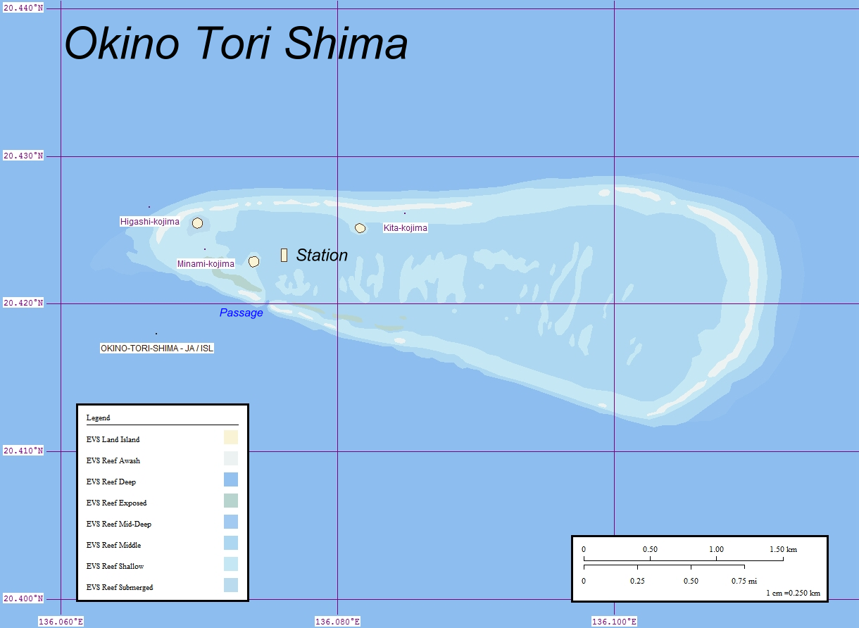
, or Parece Vela, is a coral reef with two rocks enlarged with tetrapod-cement structures. It is administered by Japan with a total shoal area of and land area . Its dry land area is mostly made up by three concrete encasings and there is a stilt platform in the lagoon housing a research station. There is a third completely artificial tetrapod-cement islet. It is located on the Palau–Kyushu Ridge in the Philippine Sea, southeast of Okidaitōjima and west-southwest of South Iwo Jima in the Bonin Islands or south of Tokyo, Japan. The atoll is the southernmost part of Japan and the only Japanese territory south of the Tropic of Cancer. Japan argues that the atoll is significant enough for it to claim a exclusive economic zone (EEZ) around it, but China, South Korea, and Taiwan dispute the Japanese EEZ, saying that the atoll does not meet the definition of an island under the United Nations Convention on the Law of the Sea. History The atoll may have been sighted first b ... [...More Info...] [...Related Items...] OR: [Wikipedia] [Google] [Baidu] |
Philippine Sea
The Philippine Sea is a marginal sea of the Western Pacific Ocean east of the Philippine archipelago (hence the name), the largest in the world, occupying an estimated surface area of . The Philippine Sea Plate forms the floor of the sea. Its western border is the first island chain to the west, comprising the Ryukyu Islands in the northwest and Taiwan in the west. Its southwestern border comprises the Philippine islands of Luzon, Catanduanes, Samar, Leyte, and Mindanao. Its northern border comprises the Japanese islands of Honshu, Shikoku and Kyūshū. Its eastern border is the second island chain to the east, comprising the Bonin Islands and Iwo Jima in the northeast, the Mariana Islands (including Guam, Saipan, and Tinian) in the due east, and Halmahera, Palau, Yap and Ulithi (of the Caroline Islands) in the southeast. Its southern border is Indonesia's Morotai Island. The sea has a complex and diverse undersea relief. The floor is formed into a structural basin by a s ... [...More Info...] [...Related Items...] OR: [Wikipedia] [Google] [Baidu] |
Bonin Islands
The Bonin Islands, also known as the , are an archipelago of over 30 subtropical and tropical islands, some directly south of Tokyo, Japan and northwest of Guam. The name "Bonin Islands" comes from the Japanese word ''bunin'' (an archaic reading of ''mujin''), meaning "no people" or "uninhabited". The only inhabited islands of the group are Chichijima (), the seat of the municipal government, and Hahajima (). Archeological evidence has revealed that some of the islands may have been prehistorically inhabited by members of an unknown Micronesian ethnicity. Ogasawara Municipality (''mura'') and Ogasawara Subprefecture take their names from the Ogasawara Group. The is also used as a wider collective term that includes other islands in Ogasawara Municipality, such as the Volcano Islands, along with three other remote islands ( Nishinoshima, Minamitorishima, and Okinotorishima). Geographically speaking, all of these islands are parts of the Nanpō Islands. A total population of ... [...More Info...] [...Related Items...] OR: [Wikipedia] [Google] [Baidu] |
Coral Reefs
A coral reef is an underwater ecosystem characterized by reef-building corals. Reefs are formed of Colony (biology), colonies of coral polyp (zoology), polyps held together by calcium carbonate. Most coral reefs are built from stony corals, whose polyps cluster in groups. Coral belongs to the Class (biology), class Anthozoa in the animal phylum Cnidaria, which includes sea anemones and jellyfish. Unlike sea anemones, corals secrete hard carbonate exoskeletons that support and protect the coral. Most reefs grow best in warm, shallow, clear, sunny and agitated water. Coral reefs first appeared 485 million years ago, at the dawn of the Early Ordovician, displacing the microbial and sponge reefs of the Cambrian. Sometimes called ''rainforests of the sea'', shallow coral reefs form some of Earth's most diverse ecosystems. They occupy less than 0.1% of the world's ocean area, about half the area of France, yet they provide a home for at least 25% of all marine species, including fis ... [...More Info...] [...Related Items...] OR: [Wikipedia] [Google] [Baidu] |
British Empire
The British Empire was composed of the dominions, colonies, protectorates, mandates, and other territories ruled or administered by the United Kingdom and its predecessor states. It began with the overseas possessions and trading posts established by England between the late 16th and early 18th centuries. At its height it was the largest empire in history and, for over a century, was the foremost global power. By 1913, the British Empire held sway over 412 million people, of the world population at the time, and by 1920, it covered , of the Earth's total land area. As a result, its constitutional, legal, linguistic, and cultural legacy is widespread. At the peak of its power, it was described as "the empire on which the sun never sets", as the Sun was always shining on at least one of its territories. During the Age of Discovery in the 15th and 16th centuries, Portugal and Spain pioneered European exploration of the globe, and in the process established large overse ... [...More Info...] [...Related Items...] OR: [Wikipedia] [Google] [Baidu] |
William Douglas (sea Captain)
William Douglas (died 1791) was a Scottish ship captain and an oceanographer maritime fur trader during the late 18th century. He worked with the British trader and Captain John Meares, commanding the ship '' Iphigenia Nubiana''. He was involved in the Nootka Crisis of 1789, which brought Britain and Spain to the brink of war. A few years later he was captain of the American ship ''Grace''. In 1791 he partnered with Captain John Kendrick in an attempt to open trade with Japan. Captain of ''Iphigenia'' Trading voyages of 1788 Douglas was an officer on ''Nootka'' during Meares's first fur trading voyage to the Pacific Northwest coast from 1786 to 1787. In 1788, in Macau, China, Meares formed a partnership of several merchants and captains, and purchased two new vessels, the snows ''Felice Adventurer'' and ''Iphigenia Nubiana''—generally called ''Felice'' and ''Iphigenia''. Meares took command of ''Felice''. He made Douglas captain of ''Iphigenia'' and second in command of the expe ... [...More Info...] [...Related Items...] OR: [Wikipedia] [Google] [Baidu] |
Sail
A sail is a tensile structure—which is made from fabric or other membrane materials—that uses wind power to propel sailing craft, including sailing ships, sailboats, windsurfers, ice boats, and even sail-powered land vehicles. Sails may be made from a combination of woven materials—including canvas or polyester cloth, laminated membranes or bonded filaments—usually in a three- or four-sided shape. A sail provides propulsive force via a combination of lift and drag, depending on its angle of attack—its angle with respect to the apparent wind. Apparent wind is the air velocity experienced on the moving craft and is the combined effect of the true wind velocity with the velocity of the sailing craft. Angle of attack is often constrained by the sailing craft's orientation to the wind or point of sail. On points of sail where it is possible to align the leading edge of the sail with the apparent wind, the sail may act as an airfoil, generating propulsive force as air p ... [...More Info...] [...Related Items...] OR: [Wikipedia] [Google] [Baidu] |
Spanish Language
Spanish ( or , Castilian) is a Romance languages, Romance language of the Indo-European language family that evolved from colloquial Latin spoken on the Iberian peninsula. Today, it is a world language, global language with more than 500 million native speakers, mainly in the Americas and Spain. Spanish is the official language of List of countries where Spanish is an official language, 20 countries. It is the world's list of languages by number of native speakers, second-most spoken native language after Mandarin Chinese; the world's list of languages by total number of speakers, fourth-most spoken language overall after English language, English, Mandarin Chinese, and Hindustani language, Hindustani (Hindi-Urdu); and the world's most widely spoken Romance languages, Romance language. The largest population of native speakers is in Mexico. Spanish is part of the Iberian Romance languages, Ibero-Romance group of languages, which evolved from several dialects of Vulgar Latin in I ... [...More Info...] [...Related Items...] OR: [Wikipedia] [Google] [Baidu] |
Miguel López De Legazpi
Miguel López de Legazpi (12 June 1502 – 20 August 1572), also known as '' El Adelantado'' and ''El Viejo'' (The Elder), was a Spaniard who, from the age of 26, lived and built a career in Mexico (then the Viceroyalty of New Spain) and, in his 60s, financed and led a colonizing expedition from Mexico to the Philippine islands. He was joined by his Mexican grandsons, Juan de Salcedo and his brother Felipe, on the expedition. Legazpi established the first Spanish settlement in the East Indies when his expedition crossed the Pacific Ocean from the New Spain, arriving in Cebu in the modern Philippine Islands in 1565. He was the first Governor-General of the Spanish East Indies, which was administered from Mexico City for the Spanish crown. It also encompassed other Pacific islands, namely Guam, the Marianas Islands, Palau, and the Carolinas. After obtaining peace with various indigenous nations and kingdoms, he made Cebu City the capital of the Spanish East Indies in 1565 and ... [...More Info...] [...Related Items...] OR: [Wikipedia] [Google] [Baidu] |
Bernardo De La Torre
Bernardo de la Torre was a Spanish sailor, primarily noted for having explored parts of the Western Pacific Ocean south of Japan in the 16th century. Bernardo de la Torre sailed under the instructions of Ruy López de Villalobos, who sent him in August 1543 on board of the ''San Juan de Letran'' (St. John of Lateran) to try to find a return route to the Mexican Western coast from the Philippines. This was the fourth such failed attempt to find the route that would be known as the Manila galleon once it was finally established in 1565. De la Torre reached 30°N but then, like his predecessors, was forced back by storms. In the course of his journey, De la Torre sighted for the first time some islets like modern-day Okinotorishima (which he named ''Parece Vela'') and, possibly, Marcus Island along some of the Bonin Islands (which he called ''Islas del Arzobispo'', "Archbishop Islands") including Chichijima (which he called ''Farfama'') and the Volcano Islands subarchipelago (which h ... [...More Info...] [...Related Items...] OR: [Wikipedia] [Google] [Baidu] |
United Nations Convention On The Law Of The Sea
The United Nations Convention on the Law of the Sea (UNCLOS), also called the Law of the Sea Convention or the Law of the Sea Treaty, is an international agreement that establishes a legal framework for all marine and maritime activities. , 167 countries and the European Union are parties. The Convention resulted from the third United Nations Conference on the Law of the Sea (UNCLOS III), which took place between 1973 and 1982. UNCLOS replaced the four treaties of the 1958 Convention on the High Seas. UNCLOS came into force in 1994, a year after Guyana became the 60th nation to ratify the treaty. It is uncertain as to what extent the Convention codifies customary international law. While the Secretary-General of the United Nations receives instruments of ratification and accession and the UN provides support for meetings of states party to the Convention, the United Nations Secretariat has no direct operational role in the implementation of the Convention. A UN specialized agenc ... [...More Info...] [...Related Items...] OR: [Wikipedia] [Google] [Baidu] |
Taiwan
Taiwan, officially the Republic of China (ROC), is a country in East Asia, at the junction of the East and South China Seas in the northwestern Pacific Ocean, with the People's Republic of China (PRC) to the northwest, Japan to the northeast, and the Philippines to the south. The territories controlled by the ROC consist of 168 islands, with a combined area of . The main island of Taiwan, also known as ''Formosa'', has an area of , with mountain ranges dominating the eastern two-thirds and plains in the western third, where its highly urbanised population is concentrated. The capital, Taipei, forms along with New Taipei City and Keelung the largest metropolitan area of Taiwan. Other major cities include Taoyuan, Taichung, Tainan, and Kaohsiung. With around 23.9 million inhabitants, Taiwan is among the most densely populated countries in the world. Taiwan has been settled for at least 25,000 years. Ancestors of Taiwanese indigenous peoples settled the isla ... [...More Info...] [...Related Items...] OR: [Wikipedia] [Google] [Baidu] |
South Korea
South Korea, officially the Republic of Korea (ROK), is a country in East Asia, constituting the southern part of the Korea, Korean Peninsula and sharing a Korean Demilitarized Zone, land border with North Korea. Its western border is formed by the Yellow Sea, while its eastern border is defined by the Sea of Japan. South Korea claims to be the sole legitimate government of the entire peninsula and List of islands of South Korea, adjacent islands. It has a Demographics of South Korea, population of 51.75 million, of which roughly half live in the Seoul Capital Area, the List of metropolitan areas by population, fourth most populous metropolitan area in the world. Other major cities include Incheon, Busan, and Daegu. The Korean Peninsula was inhabited as early as the Lower Paleolithic period. Its Gojoseon, first kingdom was noted in Chinese records in the early 7th century BCE. Following the unification of the Three Kingdoms of Korea into Unified Silla, Silla and Balhae in the ... [...More Info...] [...Related Items...] OR: [Wikipedia] [Google] [Baidu] |


