|
Oytak
Oytak Town () is a town of Akto County in Xinjiang Uygur Autonomous Region, China. Located in the middle of the northeast of the county, the town covers an area of 1,537 square kilometers with a population of 5,093 (as of 2017). It has 4 villages with 16 villagers' groups under its jurisdiction, its seat is at ''Tokkuzotak'' (). Name The name of Oytak is from Kyrgyz language, meaning "sunken ravine" (), or "a lowland in mountains" () from the old Turkic language. It is named after the geologically famous Oytak Valley () in the land. The name of the town is also spelled Oytag. Geography The town of Oytak is located between 75°58′~76°03′ east longitude and 39°12′- 39°16′ north latitude, 50 kilometers southwest of the county seat Akto Town. The Karakoram Highway runs through the town north to south, with convenient transportation. The area has a maximum length of 58 kilometers from west to east, a maximum length of 52 kilometers from north to south, and a total are ... [...More Info...] [...Related Items...] OR: [Wikipedia] [Google] [Baidu] |
Akto County
Akto County (also known as Aqtu, Aktu, or Aketao; ) is a Counties of China, county in Kizilsu Kyrgyz Autonomous Prefecture, Xinjiang, Xinjiang Uygur Autonomous Region, China. The county borders Tajikistan and Kyrgyzstan and has two Towns of China, towns, 11 Townships of China, townships, four state-owned farms and a plant nursery under its jurisdiction with the county seat being Akto Town. The county contains an area of and has a population of 231,756 (as of 2017). Akto is the westernmost border county of China. A point north of the Markansu River () on the China–Tajikistan border is the List of extreme points of China, westernmost point of China. The county is located in the southwest of Xinjiang Uygur Autonomous Region, east of the Pamir Mountains, Pamir Plateau, and the western edge of the Tarim Basin. It is located between 73°26'5" - 76°43'31" east longitude and 37°41'28" - 39°29'55" north latitude. It is bordered by Wuqia County and Shufu County to the north, by Shule ... [...More Info...] [...Related Items...] OR: [Wikipedia] [Google] [Baidu] |
Towns Of China
When referring to political divisions of China, town is the standard English translation of the Chinese (traditional: ; ). The Constitution of the People's Republic of China classifies towns as third-level administrative units, along with for example townships (). A township is typically smaller in population and more remote than a town. Similarly to a higher-level administrative units, the borders of a town would typically include an urban core (a small town with the population on the order of 10,000 people), as well as rural area with some villages (, or ). Map representation A typical provincial map would merely show a town as a circle centered at its urban area and labeled with its name, while a more detailed one (e.g., a map of a single county-level division) would also show the borders dividing the county or county-level city into towns () and/or township () and subdistrict (街道) units. The town in which the county level government, and usually the division's mai ... [...More Info...] [...Related Items...] OR: [Wikipedia] [Google] [Baidu] |
Latitude
In geography, latitude is a coordinate that specifies the north– south position of a point on the surface of the Earth or another celestial body. Latitude is given as an angle that ranges from –90° at the south pole to 90° at the north pole, with 0° at the Equator. Lines of constant latitude, or ''parallels'', run east–west as circles parallel to the equator. Latitude and ''longitude'' are used together as a coordinate pair to specify a location on the surface of the Earth. On its own, the term "latitude" normally refers to the ''geodetic latitude'' as defined below. Briefly, the geodetic latitude of a point is the angle formed between the vector perpendicular (or ''normal'') to the ellipsoidal surface from the point, and the plane of the equator. Background Two levels of abstraction are employed in the definitions of latitude and longitude. In the first step the physical surface is modeled by the geoid, a surface which approximates the mean sea level over the ocean ... [...More Info...] [...Related Items...] OR: [Wikipedia] [Google] [Baidu] |
Limestone
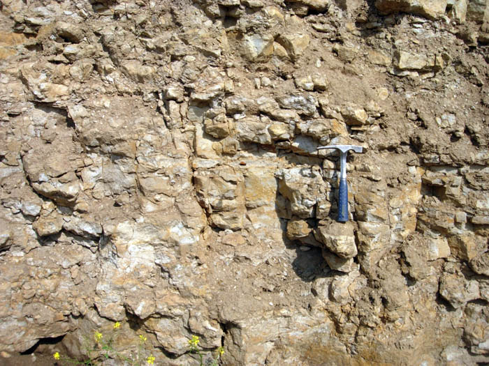
Limestone ( calcium carbonate ) is a type of carbonate sedimentary rock which is the main source of the material lime. It is composed mostly of the minerals calcite and aragonite, which are different crystal forms of . Limestone forms when these minerals precipitate out of water containing dissolved calcium. This can take place through both biological and nonbiological processes, though biological processes, such as the accumulation of corals and shells in the sea, have likely been more important for the last 540 million years. Limestone often contains fossils which provide scientists with information on ancient environments and on the evolution of life. About 20% to 25% of sedimentary rock is carbonate rock, and most of this is limestone. The remaining carbonate rock is mostly dolomite, a closely related rock, which contains a high percentage of the mineral dolomite, . ''Magnesian limestone'' is an obsolete and poorly-defined term used variously for dolomite, for limes ... [...More Info...] [...Related Items...] OR: [Wikipedia] [Google] [Baidu] |
Oil Shale
Oil shale is an organic-rich fine-grained sedimentary rock containing kerogen (a solid mixture of organic chemical compounds) from which liquid hydrocarbons can be produced. In addition to kerogen, general composition of oil shales constitutes inorganic substance and bitumens. Based on their deposition environment, oil shales are classified as marine, lacustrine and terrestrial oil shales. Oil shales differ from oil-''bearing'' shales, shale deposits that contain petroleum (tight oil) that is sometimes produced from drilled wells. Examples of oil-''bearing'' shales are the Bakken Formation, Pierre Shale, Niobrara Formation, and Eagle Ford Formation. Accordingly, shale oil produced from oil shale should not be confused with tight oil, which is also frequently called shale oil. Deposits of oil shale occur around the world, including major deposits in the United States. A 2016 estimate of global deposits set the total world resources of oil shale equivalent of of oil in place. ... [...More Info...] [...Related Items...] OR: [Wikipedia] [Google] [Baidu] |
Mongolian Gazelle
The Mongolian gazelle (''Procapra gutturosa''), or dzeren (russian: Дзерэн), is a medium-sized antelope native to the semiarid Central Asian steppes of Mongolia, as well as some parts of Siberia and China. The name ''dzeren'' is Russian misinterpretation of the Mongolian language name of ''zeer'' ( mn, Зээр) or Buryat zeeren ( Buryat: Зээрэн). Description In the summer, its coat is light brown with pinkish tones, becoming longer and paler during the winter. It also has a distinctive heart-shaped white patch on its rump area, divided by a median line of darker color. The male has lyre-shaped horns which curl backwards from the forehead. It is an extremely fast runner and good swimmer. In the winter, they are mostly diurnal, but in the summer, they are active shortly after sunrise and before sunset. They tend to travel a lot, and migrations takes place in spring and autumn, but the distance and direction vary depending on the weather and food availability. Behav ... [...More Info...] [...Related Items...] OR: [Wikipedia] [Google] [Baidu] |
Rock Ptarmigan
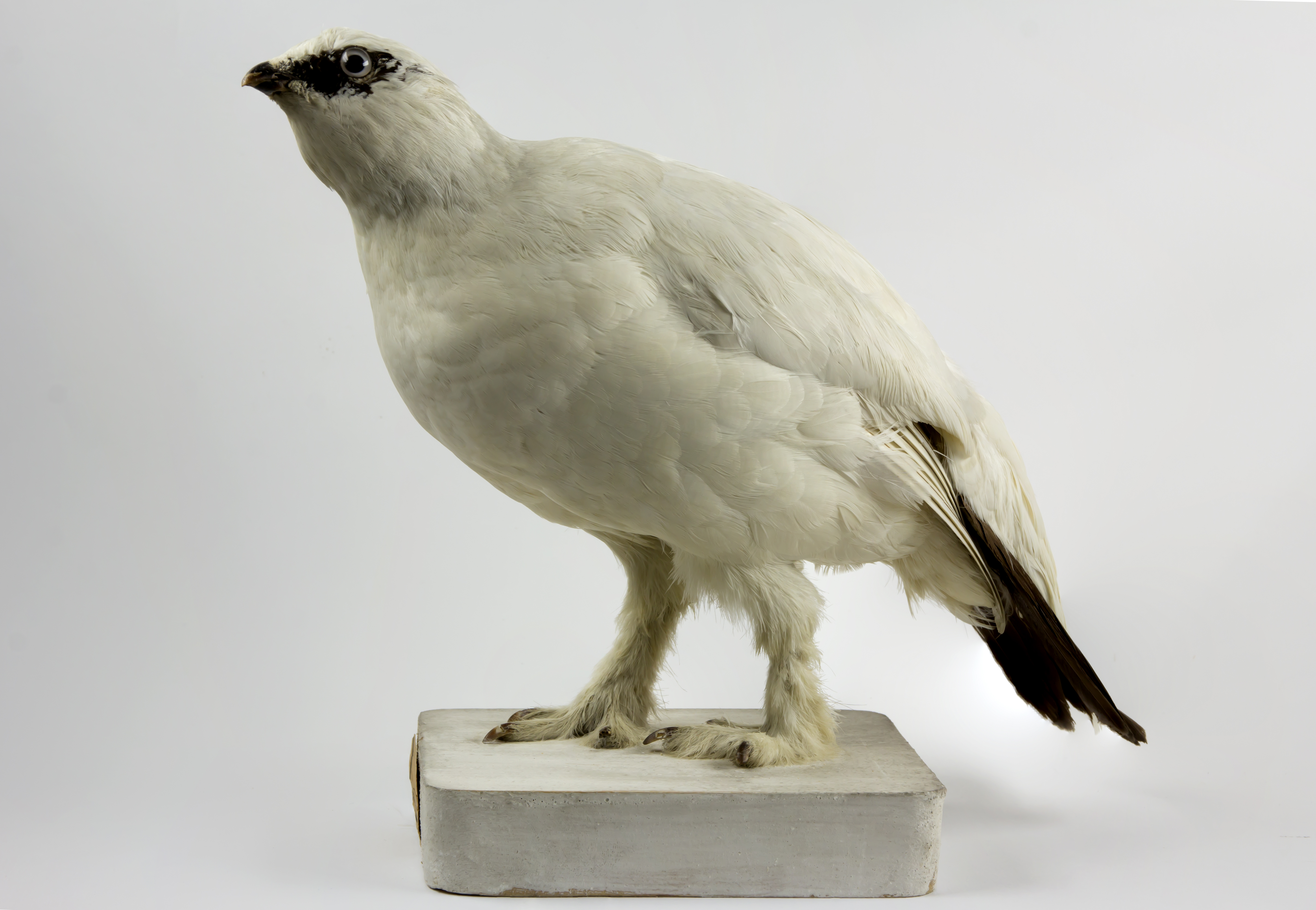
The rock ptarmigan (''Lagopus muta'') is a medium-sized game bird in the grouse family. It is known simply as the ptarmigan in the UK. It is the official bird for the Canadian territory of Nunavut, where it is known as the ''aqiggiq'' (ᐊᕿᒡᒋᖅ), and the official game bird for the province of Newfoundland and Labrador. In Japan, it is known as the ''raichō'' (雷鳥), which means "thunder bird". It is the official bird of Gifu, Nagano, and Toyama Prefectures and is a protected species nationwide. Unlike many arctic bird species, ptarmigan do not gain substantial mass to hibernate over winter. Etymology The ptarmigan's genus name, ''Lagopus'', is derived from Ancient Greek ''lagos'' (λαγώς ''lagṓs''), meaning "hare", + ''pous'' (πούς ''poús''), "foot", in reference to the bird's feathered legs. The species name, ''muta'', comes from New Latin and means "mute", referring to the simple croaking song of the male. It was for a long time misspelt ''mutus'', in the ... [...More Info...] [...Related Items...] OR: [Wikipedia] [Google] [Baidu] |
Water System
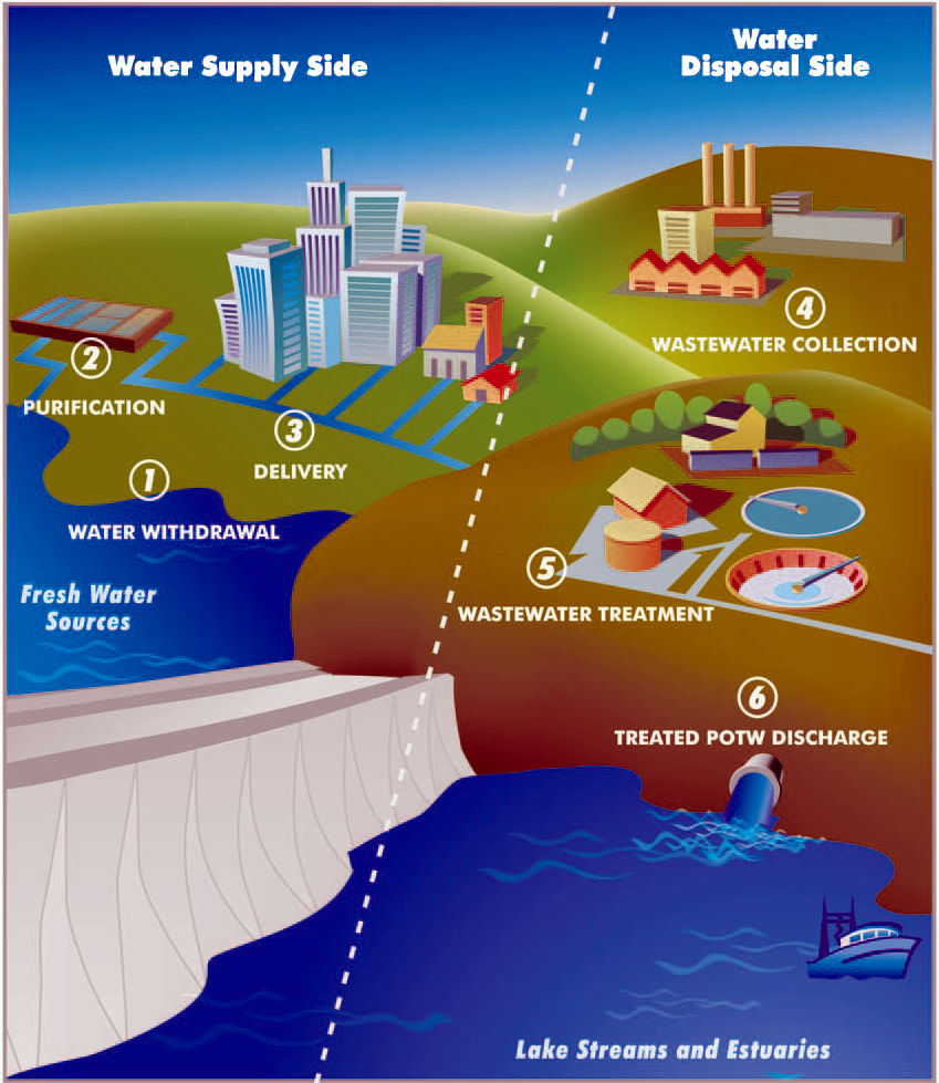
A water supply network or water supply system is a system of engineered hydrologic and hydraulic components that provide water supply. A water supply system typically includes the following: # A drainage basin (see water purification – sources of drinking water) # A raw water collection point (above or below ground) where the water accumulates, such as a lake, a river, or groundwater from an underground aquifer. Raw water may be transferred using uncovered ground-level aqueducts, covered tunnels, or underground water pipes to water purification facilities. # Water purification facilities. Treated water is transferred using water pipes (usually underground). # Water storage facilities such as reservoirs, water tanks, or water towers. Smaller water systems may store the water in cisterns or pressure vessels. Tall buildings may also need to store water locally in pressure vessels in order for the water to reach the upper floors. # Additional water pressurizing components such as ... [...More Info...] [...Related Items...] OR: [Wikipedia] [Google] [Baidu] |
Auto-defrost
Auto-defrost, automatic defrost or self-defrosting is a technique which regularly defrosts the evaporator in a refrigerator or freezer. Appliances using this technique are often called frost free, frostless, or no-frost. Mechanism The defrost mechanism in a refrigerator heats the cooling element (evaporator coil) for a short period of time and melts the frost that has formed on it. The resulting water drains through a duct at the back of the unit. Defrosting is controlled by an electric or electronic timer: For every 6, 8, 10, 12 or 24 hours of compressor operation it turns on a defrost heater for 15 minutes to half an hour. The defrost heater, having a typical power rating of 350 W to 600 W, is mounted just below the evaporator in top- and bottom-freezer models and below and sometimes also in the middle of the evaporator in side-by-side models. It may be protected from short circuits by means of fusible links. In older refrigerators the timer ran continuously. ... [...More Info...] [...Related Items...] OR: [Wikipedia] [Google] [Baidu] |
Celsius
The degree Celsius is the unit of temperature on the Celsius scale (originally known as the centigrade scale outside Sweden), one of two temperature scales used in the International System of Units (SI), the other being the Kelvin scale. The degree Celsius (symbol: °C) can refer to a specific temperature on the Celsius scale or a unit to indicate a difference or range between two temperatures. It is named after the Swedish astronomer Anders Celsius (1701–1744), who developed a similar temperature scale in 1742. Before being renamed in 1948 to honour Anders Celsius, the unit was called ''centigrade'', from the Latin ''centum'', which means 100, and ''gradus'', which means steps. Most major countries use this scale; the other major scale, Fahrenheit, is still used in the United States, some island territories, and Liberia. The Kelvin scale is of use in the sciences, with representing absolute zero. Since 1743 the Celsius scale has been based on 0 °C for the freezing ... [...More Info...] [...Related Items...] OR: [Wikipedia] [Google] [Baidu] |
Forest Land
Forest cover is the amount of forest that covers a particular area of land. It may be measured as relative (in percent) or absolute (in square kilometres/square miles). Around a third of the world's surface is covered with forest, with closed-canopy forest accounting for 4 - 5 billion hectares of land. Forests provide many ecosystem services that humans and animals cannot survive without, but anthropogenic actions and climate change are threatening global forest cover in potentially irreversible ways. Global Patterns Forest Cover By The Numbers According to the FAO's Global Forest Resources Assessment 2020, the world has a total forest area of 4.06 billion hectares (10.0 billion acres), which is 31% of the total land area. More than one-third of the world's forest cover is primary forest: naturally regenerated forests with native species and no visible indication of human activity. More than half (54%) of the world's forests are found in only five countries (Brazil, Canada, Ch ... [...More Info...] [...Related Items...] OR: [Wikipedia] [Google] [Baidu] |
Orchard
An orchard is an intentional plantation of trees or shrubs that is maintained for food production. Orchards comprise fruit- or nut-producing trees which are generally grown for commercial production. Orchards are also sometimes a feature of large gardens, where they serve an aesthetic as well as a productive purpose. A fruit garden is generally synonymous with an orchard, although it is set on a smaller non-commercial scale and may emphasize berry shrubs in preference to fruit trees. Most temperate-zone orchards are laid out in a regular grid, with a grazed or mown grass or bare soil base that makes maintenance and fruit gathering easy. Most modern commercial orchards are planted for a single variety of fruit. While the importance of introducing biodiversity is recognized in forest plantations, it would seem to be beneficial to introduce some genetic diversity in orchard plantations as well by interspersing other trees through the orchard. Genetic diversity in an orchard would p ... [...More Info...] [...Related Items...] OR: [Wikipedia] [Google] [Baidu] |


