|
Owens Valley
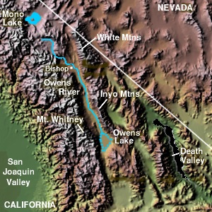
Owens Valley (Numic: ''Payahǖǖnadǖ'', meaning "place of flowing water") is an arid valley of the Owens River in eastern California in the United States. It is located to the east of the Sierra Nevada, west of the White Mountains and Inyo Mountains, and north of the Mojave Desert. It sits on the west edge of the Great Basin. The mountain peaks on the West side (including Mount Whitney) reach above in elevation, while the floor of the Owens Valley is about , making the valley the deepest in the United States. The Sierra Nevada casts the valley in a rain shadow, which makes Owens Valley "the Land of Little Rain." The bed of Owens Lake, now a predominantly dry endorheic alkali flat, sits on the southern end of the valley. The valley provides water to the Los Angeles Aqueduct, the source of one-third of the water for Los Angeles, and was the area at the center of one of the fiercest and longest-running episodes of the California Water Wars. These episodes inspired aspects of th ... [...More Info...] [...Related Items...] OR: [Wikipedia] [Google] [Baidu] |
Sierra Nevada Fault
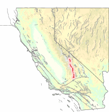
The Sierra Nevada Fault is an active seismic fault along the eastern edge of the Sierra Nevada mountain block in California. It forms the eastern escarpment of the Sierra Nevada, extending roughly from just north of the Garlock Fault to the Cascade Range. Tectonic activity Uplift on this fault is about 0.01–0.03 mm per year. This movement, combined with the activity of the adjacent Owens Valley and Lone Pine faults, is responsible for the continuing rise of the Sierra Nevada Mountains. No large earthquake has been reported on this fault in recorded history. The largest earthquake in its vicinity was the 1872 Lone Pine earthquake, which was on the adjacent Owens Valley Fault and had an estimated moment magnitude of 7.4–7.9. History Around 200 million years ago, the ancient oceanic Farallon Plate began to subduct beneath the North American Plate. As the Farallon moved eastward, it was overridden by the North American, and the moisture within it was figuratively baked ... [...More Info...] [...Related Items...] OR: [Wikipedia] [Google] [Baidu] |
Owens River
The Owens River is a river in eastern California in the United States, approximately long.U.S. Geological Survey. National Hydrography Dataset high-resolution flowline dataThe National Map accessed March 17, 2011, It drains into and through the Owens Valley, an arid basin between the eastern slope of the Sierra Nevada and the western faces of the Inyo and White Mountains. The river terminates at the endorheic Owens Lake south of Lone Pine, at the bottom of a watershed. In the early 1900s, the Owens River was the focus of the California Water Wars, fought between the city of Los Angeles and the inhabitants of Owens Valley over the construction of the Los Angeles Aqueduct. Since 1913, the Owens River has been diverted to Los Angeles, causing the ruin of the valley's economy and the drying of Owens Lake. In winter 2006, the Los Angeles Department of Water and Power restored 5% of the pre-aqueduct flow to the river by court order, allowing the Owens River Gorge, the river bed ... [...More Info...] [...Related Items...] OR: [Wikipedia] [Google] [Baidu] |
Rain Shadow
A rain shadow is an area of significantly reduced rainfall behind a mountainous region, on the side facing away from prevailing winds, known as its leeward side. Evaporated moisture from water bodies (such as oceans and large lakes) is carried by the prevailing onshore breezes towards the drier and hotter inland areas. When encountering elevated landforms, the moist air is driven upslope towards the peak, where it expands, cools, and its moisture condenses and starts to precipitate. If the landforms are tall and wide enough, most of the humidity will be lost to precipitation over the windward side (also known as the ''rainward'' side) before ever making it past the top. As the air descends the leeward side of the landforms, it is compressed and heated, producing foehn winds that ''absorb'' moisture downslope and cast a broad "shadow" of dry climate region behind the mountain crests. This climate typically takes the form of shrub–steppe, xeric shrublands or even d ... [...More Info...] [...Related Items...] OR: [Wikipedia] [Google] [Baidu] |
Mono Basin
The Mono Basin is an endorheic drainage basin located east of Yosemite National Park in California and Nevada. It is bordered to the west by the Sierra Nevada, to the east by the Cowtrack Mountains, to the north by the Bodie Hills, and to the south by the north ridge of the Long Valley Caldera. Estimates of the size of the basin range from 634 to 801 square miles, and the basin's elevation ranges from around 6,380 feet (level of Mono Lake as of 1986) to 13,061 feet atop Mount Dana near the Sierra Crest. Notable features in the basin include Mono Lake and the Mono-Inyo Craters, as well as the town of Lee Vining. Geology Geologically the basin is a structural basin that is bordered to the west by the frontal fault of the Sierra Nevada. The basin is part of the Walker Lane, an area where much of the deformation between the North American Plate and the Pacific Plate occurs. The basin was created by geological forces over the last five million years by crustal stretching of t ... [...More Info...] [...Related Items...] OR: [Wikipedia] [Google] [Baidu] |
Escarpment
An escarpment is a steep slope or long cliff that forms as a result of faulting or erosion and separates two relatively level areas having different elevations. The terms ''scarp'' and ''scarp face'' are often used interchangeably with ''escarpment''. Some sources differentiate the two terms, with ''escarpment'' referring to the margin between two landforms, and ''scarp'' referring to a cliff or a steep slope. In this usage an escarpment is a ridge which has a gentle slope on one side and a steep scarp on the other side. More loosely, the term ''scarp'' also describes a zone between a coastal lowland and a continental plateau which shows a marked, abrupt change in elevation caused by coastal erosion at the base of the plateau. Formation and description Scarps are generally formed by one of two processes: either by differential erosion of sedimentary rocks, or by movement of the Earth's crust at a geologic fault. The first process is the more common type: the escarpment is a ... [...More Info...] [...Related Items...] OR: [Wikipedia] [Google] [Baidu] |
Earthquake
An earthquake (also known as a quake, tremor or temblor) is the shaking of the surface of the Earth resulting from a sudden release of energy in the Earth's lithosphere that creates seismic waves. Earthquakes can range in intensity, from those that are so weak that they cannot be felt, to those violent enough to propel objects and people into the air, damage critical infrastructure, and wreak destruction across entire cities. The seismic activity of an area is the frequency, type, and size of earthquakes experienced over a particular time period. The seismicity at a particular location in the Earth is the average rate of seismic energy release per unit volume. The word ''tremor'' is also used for Episodic tremor and slip, non-earthquake seismic rumbling. At the Earth's surface, earthquakes manifest themselves by shaking and displacing or disrupting the ground. When the epicenter of a large earthquake is located offshore, the seabed may be displaced sufficiently to cause ... [...More Info...] [...Related Items...] OR: [Wikipedia] [Google] [Baidu] |
White Mountains Fault
White is the lightest color and is achromatic (having no hue). It is the color of objects such as snow, chalk, and milk, and is the opposite of black. White objects fully reflect and scatter all the visible wavelengths of light. White on television and computer screens is created by a mixture of red, blue, and green light. The color white can be given with white pigments, especially titanium dioxide. In ancient Egypt and ancient Rome, priestesses wore white as a symbol of purity, and Romans wore white togas as symbols of citizenship. In the Middle Ages and Renaissance a white unicorn symbolized chastity, and a white lamb sacrifice and purity. It was the royal color of the kings of France, and of the monarchist movement that opposed the Bolsheviks during the Russian Civil War (1917–1922). Greek and Roman temples were faced with white marble, and beginning in the 18th century, with the advent of neoclassical architecture, white became the most common color of new churches ... [...More Info...] [...Related Items...] OR: [Wikipedia] [Google] [Baidu] |
Chinatown (1974 Film)
''Chinatown'' is a 1974 American neo-noir mystery film directed by Roman Polanski from a screenplay by Robert Towne, starring Jack Nicholson and Faye Dunaway. The film was inspired by the California water wars, a series of disputes over southern California water at the beginning of the 20th century, by which Los Angeles interests secured water rights in the Owens Valley. The Robert Evans production, released by Paramount Pictures, was the director's last film in the United States and features many elements of film noir, particularly a multi-layered story that is part mystery and part psychological drama.Wasson, Sam. ''The Big Goodbye. Chinatown and the Last Years of Hollywood'', Flatiron Books, 2020. In 1991, the film was selected by the Library of Congress for preservation in the United States National Film Registry as being "culturally, historically or aesthetically significant" and it is frequently listed as one of the greatest films of all time. At the 47th Academy Aw ... [...More Info...] [...Related Items...] OR: [Wikipedia] [Google] [Baidu] |
Los Angeles
Los Angeles ( ; es, Los Ángeles, link=no , ), often referred to by its initials L.A., is the largest city in the state of California and the second most populous city in the United States after New York City, as well as one of the world's most populous megacities. Los Angeles is the commercial, financial, and cultural center of Southern California. With a population of roughly 3.9 million residents within the city limits , Los Angeles is known for its Mediterranean climate, ethnic and cultural diversity, being the home of the Hollywood film industry, and its sprawling metropolitan area. The city of Los Angeles lies in a basin in Southern California adjacent to the Pacific Ocean in the west and extending through the Santa Monica Mountains and north into the San Fernando Valley, with the city bordering the San Gabriel Valley to it's east. It covers about , and is the county seat of Los Angeles County, which is the most populous county in the United States with an ... [...More Info...] [...Related Items...] OR: [Wikipedia] [Google] [Baidu] |
Los Angeles Aqueduct
The Los Angeles Aqueduct system, comprising the Los Angeles Aqueduct (Owens Valley aqueduct) and the Second Los Angeles Aqueduct, is a water conveyance system, built and operated by the Los Angeles Department of Water and Power. The Owens Valley aqueduct was designed and built by the city's water department, at the time named The Bureau of Los Angeles Aqueduct, under the supervision of the department's Chief Engineer William Mulholland. The system delivers water from the Owens River in the Eastern Sierra Nevada Mountains to Los Angeles, California. The aqueduct's construction was controversial from the start, as water diversions to Los Angeles eliminated the Owens Valley as a viable farming community. Clauses in the city's charter originally stated that the city could not sell or provide surplus water to any area outside the city, forcing adjacent communities to annex themselves into Los Angeles. The aqueduct's infrastructure also included the completion of the St. Francis ... [...More Info...] [...Related Items...] OR: [Wikipedia] [Google] [Baidu] |


