|
Overtown, Lancashire
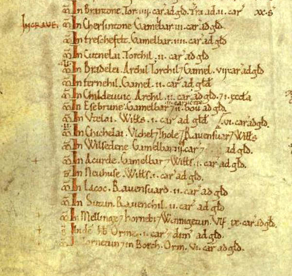
Burrow-with-Burrow is a civil parish in the English county of Lancashire. The parish of Burrow-with-Burrow had a population of 191 recorded in the 2001 census, decreasing to 182 at the 2011 Census. It is on the River Lune south of the Cumbrian town Kirkby Lonsdale. Administratively it forms part of the City of Lancaster, Lancaster itself being some away. Settlements in the parish include Nether Burrow, Over Burrow, Overtown and Cowan Bridge. The parish is sometimes referred to as "Burrow" for brevity. History Roman pavements, altars, inscriptions, urns, and coins have been found here; and a Roman milestone is on the road. In 1086, the Domesday Book listed under Craven: ''Torntun & in Borch, Orm vi curactes ad geld.'' (Thornton-in-Lonsdale with Burrow-with-Burrow Orm has c720 acres /290ha of plough-land to be taxed.) That manor would also have included grazing land but since only arable land was tallied the total area can only be induced. Orm was one of the family of ... [...More Info...] [...Related Items...] OR: [Wikipedia] [Google] [Baidu] |
City Of Lancaster
The City of Lancaster () is a local government district of Lancashire, England, with the status of a city and non-metropolitan district. It is named after its largest settlement, Lancaster, but covers a far larger area, which includes the towns of Morecambe, Heysham, and Carnforth, as well as outlying villages, farms, rural hinterland and (since 1 August 2016) a section of the Yorkshire Dales National Park. The district has a population of (), and an area of . History The current city boundaries were set as part of the provisions of the Local Government Act 1972, which created a non-metropolitan district on 1 April 1974 covering the territory of five former districts, which were abolished at the same time: *Carnforth Urban District * Lancaster Municipal Borough *Lancaster Rural District * Lunesdale Rural District * Morecambe and Heysham Municipal Borough The city status which had been held by the old municipal borough of Lancaster since 1937 was transferred to the non-metrop ... [...More Info...] [...Related Items...] OR: [Wikipedia] [Google] [Baidu] |
Nether Burrow
Nether Burrow is a small hamlet in the Lunesdale Valley of North Lancashire, England. It is a small settlement on the banks of the River Lune. There is not much there but there is a pub called the Highwayman Inn. It is on the A683 road between Lancaster and Kirkby Lonsdale. It forms part of the civil parish In England, a civil parish is a type of administrative parish used for local government. It is a territorial designation which is the lowest tier of local government below districts and counties, or their combined form, the unitary authorit ... with the unusual name of Burrow-with-Burrow. Geography of the City of Lancaster Villages in Lancashire {{Lancashire-geo-stub ... [...More Info...] [...Related Items...] OR: [Wikipedia] [Google] [Baidu] |
Listed Buildings In Burrow-with-Burrow
{{disambig ...
Listed may refer to: * Listed, Bornholm, a fishing village on the Danish island of Bornholm * Listed (MMM program), a television show on MuchMoreMusic * Endangered species in biology * Listed building, in architecture, designation of a historically significant structure * Listed company, see listing (finance), a public company whose shares are traded e.g. on a stock exchange * UL Listed, a certification mark * A category of Group races in horse racing See also * Listing (other) Listing may refer to: * Enumeration of a set of items in the form of a list * Johann Benedict Listing (1808–1882), German mathematician. * Listing (computer), a computer code listing. * Listing (finance), the placing of a company's shares on th ... [...More Info...] [...Related Items...] OR: [Wikipedia] [Google] [Baidu] |
Burrow Hall
Burrow Hall is a large 18th-century country house in Burrow-with-Burrow, Lancashire, England, which lies in the Lune Valley on the A683 some south of Kirkby Lonsdale. The house is built of sandstone ashlar with a slate roof. The south facing façade is composed of seven bays, three of which project under a pediment. The east facing façade has ten bays. The hall is recorded in the National Heritage List for England as a designated Grade I listed building, and the stable block to the rear is listed Grade II*. The house has a number of impressive ornate plaster ceilings, attributed to Italians Francesco Vassalli and Martino Quadry, who were also thought to have done work at Towneley Hall, Burnley and Shugborough in Staffordshire. Burrow Hall was built over the site of a Roman Fort, the initial construction of which is thought to date to the Flavian period. Remains are thought to be under the Main Hall, although archaeological work during the renovations in 2014 u ... [...More Info...] [...Related Items...] OR: [Wikipedia] [Google] [Baidu] |
Tostig Godwinson
Tostig Godwinson ( 102925 September 1066) was an Anglo-Saxon Earl of Northumbria and brother of King Harold Godwinson. After being exiled by his brother, Tostig supported the Norwegian king Harald Hardrada's invasion of England, and was killed alongside Hardrada at the Battle of Stamford Bridge in 1066. Background Tostig was the third son of the Anglo-Saxon nobleman Godwin, Earl of Wessex and Gytha Thorkelsdóttir, the daughter of Danish chieftain Thorgil Sprakling. In 1051, he married Judith of Flanders, the only child of Baldwin IV, Count of Flanders by his second wife, Eleanor of Normandy. In 1086, the Domesday Book recorded twenty-six vills or townships as being held by Earl Tostig, forming the Manor of Hougun which now forms part of the county of Cumbria in north-west England. Earl of Northumbria In the 19th century, the antiquarian Edward Augustus Freeman posited a hypothesis claiming that Edward the Confessor, King of England, was pursuing a policy of " Normani ... [...More Info...] [...Related Items...] OR: [Wikipedia] [Google] [Baidu] |
Manorialism
Manorialism, also known as the manor system or manorial system, was the method of land ownership (or "tenure") in parts of Europe, notably France and later England, during the Middle Ages. Its defining features included a large, sometimes fortified manor house in which the lord of the manor and his dependents lived and administered a rural estate, and a population of labourers who worked the surrounding land to support themselves and the lord. These labourers fulfilled their obligations with labour time or in-kind produce at first, and later by cash payment as commercial activity increased. Manorialism is sometimes included as part of the feudal system. Manorialism originated in the Roman villa system of the Late Roman Empire, and was widely practiced in medieval western Europe and parts of central Europe. An essential element of feudal society, manorialism was slowly replaced by the advent of a money-based market economy and new forms of agrarian contract. In examining the o ... [...More Info...] [...Related Items...] OR: [Wikipedia] [Google] [Baidu] |
Thornton-in-Lonsdale
Thornton in Lonsdale is a village and civil parish in the Craven District and ceremonial county of North Yorkshire in England. It is very close to the border with Cumbria and Lancashire and is north of Ingleton and south-east of Kirkby Lonsdale, and has a population of 308, falling to 288 at the 2011 Census. Its main claims to fame are the Marton Arms pub and St Oswald's Church, Sir Arthur Conan Doyle married his first wife at this church in 1885 and held his reception at The Marton Arms before setting off to Ireland on honeymoon. Doyle's mother resided at nearby Masongill from 1882 to 1917. History In 1086 the ''Domesday Book'' listed on folio 301v under Craven ''Torntun & in Borch, Orm vi curactes ad geld.'' – that is in ''Thornton in Lonsdale with Burrow-with-Burrow Orm has circa 720 acres of plough-land to be taxed''. This manor belonged to Orm, one of the family of Norse Noblemen who held the most land in Northern England. All estates would also include ... [...More Info...] [...Related Items...] OR: [Wikipedia] [Google] [Baidu] |
Domesday Book
Domesday Book () – the Middle English spelling of "Doomsday Book" – is a manuscript record of the "Great Survey" of much of England and parts of Wales completed in 1086 by order of King William I, known as William the Conqueror. The manuscript was originally known by the Latin name ''Liber de Wintonia'', meaning "Book of Winchester", where it was originally kept in the royal treasury. The '' Anglo-Saxon Chronicle'' states that in 1085 the king sent his agents to survey every shire in England, to list his holdings and dues owed to him. Written in Medieval Latin, it was highly abbreviated and included some vernacular native terms without Latin equivalents. The survey's main purpose was to record the annual value of every piece of landed property to its lord, and the resources in land, manpower, and livestock from which the value derived. The name "Domesday Book" came into use in the 12th century. Richard FitzNeal wrote in the ''Dialogus de Scaccario'' ( 1179) that the book ... [...More Info...] [...Related Items...] OR: [Wikipedia] [Google] [Baidu] |
Domesday Book Folio 301v Ms Detail
Domesday Book () – the Middle English spelling of "Doomsday Book" – is a manuscript record of the "Great Survey" of much of England and parts of Wales completed in 1086 by order of King William I, known as William the Conqueror. The manuscript was originally known by the Latin name ''Liber de Wintonia'', meaning "Book of Winchester", where it was originally kept in the royal treasury. The '' Anglo-Saxon Chronicle'' states that in 1085 the king sent his agents to survey every shire in England, to list his holdings and dues owed to him. Written in Medieval Latin, it was highly abbreviated and included some vernacular native terms without Latin equivalents. The survey's main purpose was to record the annual value of every piece of landed property to its lord, and the resources in land, manpower, and livestock from which the value derived. The name "Domesday Book" came into use in the 12th century. Richard FitzNeal wrote in the ''Dialogus de Scaccario'' ( 1179) that the book ... [...More Info...] [...Related Items...] OR: [Wikipedia] [Google] [Baidu] |
Cowan Bridge
Cowan Bridge is a village in the English county of Lancashire. It is south-east of the town of Kirkby Lonsdale where the main A65 road crosses the Leck Beck. It forms part of the civil parish of Burrow-with-Burrow. Clergy Daughters' School Cowan Bridge was the site of the Clergy Daughters' School attended by Charlotte and Emily Brontë, the notable 19th-century writers, and their older sisters Maria and Elizabeth, who died after experiencing harsh privations at the school. There is a plaque commemorating this association on the former school building, which partially survives. The churchyard of St Peter's Church, Leck, has graves of several of the children who died at the school. Charlotte described the abuses, the typhus epidemic in which seven pupils died, the scandal which followed, and subsequent reform of the school in ''Jane Eyre''. The character of Helen Burns is based closely on Maria. Reverend Brocklehurst is a portrait of William Carus Wilson, who managed the sch ... [...More Info...] [...Related Items...] OR: [Wikipedia] [Google] [Baidu] |
Lancaster, Lancashire
Lancaster (, ) is a city and the county town of Lancashire, England, standing on the River Lune. Its population of 52,234 compares with one of 138,375 in the wider City of Lancaster local government district. The House of Lancaster was a branch of the English royal family. The Duchy of Lancaster still holds large estates on behalf of Charles III, who is also Duke of Lancaster. Its long history is marked by Lancaster Castle, Lancaster Priory Church, Lancaster Cathedral and the Ashton Memorial. It is the seat of Lancaster University and has a campus of the University of Cumbria. The Port of Lancaster played a big role in the city's growth, but for many years the outport of Glasson Dock has become the main shipping facility. History The name of the city first appeared in the Domesday Book of 1086, as ''Loncastre'', where "Lon" refers to the River Lune and "castre" (from the Old English ''cæster'' and Latin ''castrum'' for "fort") to the Roman fort that stood on the site. Ro ... [...More Info...] [...Related Items...] OR: [Wikipedia] [Google] [Baidu] |
Lancashire
Lancashire ( , ; abbreviated Lancs) is the name of a historic county, ceremonial county, and non-metropolitan county in North West England. The boundaries of these three areas differ significantly. The non-metropolitan county of Lancashire was created by the Local Government Act 1972. It is administered by Lancashire County Council, based in Preston, and twelve district councils. Although Lancaster is still considered the county town, Preston is the administrative centre of the non-metropolitan county. The ceremonial county has the same boundaries except that it also includes Blackpool and Blackburn with Darwen, which are unitary authorities. The historic county of Lancashire is larger and includes the cities of Manchester and Liverpool as well as the Furness and Cartmel peninsulas, but excludes Bowland area of the West Riding of Yorkshire transferred to the non-metropolitan county in 1974 History Before the county During Roman times the area was part of the Bri ... [...More Info...] [...Related Items...] OR: [Wikipedia] [Google] [Baidu] |

.jpg)


