|
Oosterhout
Oosterhout (; from ''ooster'', "eastern", and ''hout'', "woods") is a municipality and a city in the southern Netherlands. The municipality had a population of in . Population centers The municipality of Oosterhout includes the following places: History Oosterhout is mentioned for the first time in 1277, although archaeological excavations showed the existence of human settlements in the area in prehistoric times. The Knights Templar had a temple here dedicated to St. John the Baptist. It was home to a castle which later acquired control over the surrounding area, up to Breda and Bergen op Zoom. The castle was destroyed by Spanish troops during the Eighty Years War, in 1573; only a tower of it survives today. The city became the seat of a flourishing ceramics industry, which lasted until the 19th century. In 1625 the city was besieged by Frederick Henry, Prince of Orange, and suffered heavy damage. Despite the rise of Protestantism, it was home to several Catholic monast ... [...More Info...] [...Related Items...] OR: [Wikipedia] [Google] [Baidu] |
Dorst
Dorst is a village in the municipality Oosterhout, in the Dutch province North Brabant. Dorst is located near Rijen and the nearest cities are Breda, Oosterhout and Tilburg. Toponymy The name ''Dorst'' is supposed to originate from ''Dornt'', which would refer to meidoorn, that was used as plot separation. Another explanation is a contraction of the words "De Horst". History Dorst was first mentioned in 1290, then in 1323 and thereafter more regularly. ''Willem van Duivenvoorde'' was the lord of Kasteel Strijen in 1325 and thus also of Dorst. In 1511 the chapel of Dorst was first mentioned. The chapel was devoted to the Holy Trinity. In 1648 the chapel had to be closed and it feel into disrepair. In 1675 the Catholics could use a barn church instead. In 1689 there was a Saint Marcoufrelic donated, which made Dorst into a sanctuary. In 1835 there was built a church across from the chapel. The chapel was demolished after that. In 1912 the church was also demolished and th ... [...More Info...] [...Related Items...] OR: [Wikipedia] [Google] [Baidu] |
Den Hout
Den Hout is a village in the Dutch province of North Brabant. It is located in the municipality of Oosterhout. The village was first mentioned in 1311 as "Rolinus dictus van den Houte", and means deciduous forest. The area around Den Hout was settled during Roman times, but abandoned in 273. Den Hout developed in the Middle Ages around a triangular village square. The St Cornelius Church was built between 1877 and 1878 in Gothic Revival style and as an octagon In geometry, an octagon (from the Greek ὀκτάγωνον ''oktágōnon'', "eight angles") is an eight-sided polygon or 8-gon. A ''regular octagon'' has Schläfli symbol and can also be constructed as a quasiregular truncated square, t, wh ... spire. Den Hout was home to 650 people in 1840. Gallery File:Paviljoen Het Houtse Meer DSCF8553.jpg, Pavillion Het Houtse Meer File:P1040943 copyCorneliuskerk (Den Hout).jpg, St Cornelius Church File:08262002-07 R.K. verenigingsgbouw Den Hout.jpg, Association building ... [...More Info...] [...Related Items...] OR: [Wikipedia] [Google] [Baidu] |
Municipalities Of The Netherlands
As of 24 March 2022, there are 344 municipalities ( nl, gemeenten) and three special municipalities () in the Netherlands. The latter is the status of three of the six island territories that make up the Dutch Caribbean. Municipalities are the second-level administrative division, or public bodies (), in the Netherlands and are subdivisions of their respective provinces. Their duties are delegated to them by the central government and they are ruled by a municipal council that is elected every four years. Municipal mergers have reduced the total number of municipalities by two-thirds since the first official boundaries were created in the mid 19th century. Municipalities themselves are informally subdivided into districts and neighbourhoods for administrative and statistical purposes. These municipalities come in a wide range of sizes, Westervoort is the smallest with a land area of and Súdwest-Fryslân the largest with a land area of . Schiermonnikoog is both the least p ... [...More Info...] [...Related Items...] OR: [Wikipedia] [Google] [Baidu] |
Breda
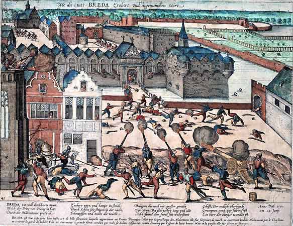
Breda () is a city and municipality in the southern part of the Netherlands, located in the province of North Brabant. The name derived from ''brede Aa'' ('wide Aa' or 'broad Aa') and refers to the confluence of the rivers Mark and Aa. Breda has 185,072 inhabitants on 13 September 2022 and is part of the Brabantse Stedenrij; it is the ninth largest city/municipality in the country, and the third largest in North Brabant after Eindhoven and Tilburg. It is equidistant between Rotterdam and Antwerp. As a fortified city, it was of strategic military and political significance. Although a direct Fiefdom of the Holy Roman Emperor, the city obtained a municipal charter; the acquisition of Breda, through marriage, by the House of Nassau ensured that Breda would be at the centre of political and social life in the Low Countries. Breda had a population of in ; the metropolitan area had a population of . History In the 11th century, Breda was a direct fief of the Holy Rom ... [...More Info...] [...Related Items...] OR: [Wikipedia] [Google] [Baidu] |
Telephone Numbers In The Netherlands
Telephone numbers in the Netherlands are administered by the Ministry of Economic Affairs, Agriculture and Innovation of the Netherlands and may be grouped into three general categories: geographical numbers, non-geographical numbers, and numbers for public services. Geographical telephone numbers are sequences of 9 digits (0-9) and consist of an area code of two or three digits and a subscriber number of seven or six digits, respectively. When dialled within the country, the number must be prefixed with the trunk access code 0, identifying a destination telephone line in the Dutch telephone network. Non-geographical numbers have no fixed length, but also required the dialling of the trunk access code (0). They are used for mobile telephone networks and other designated service types, such as toll-free dialling, Internet access, voice over IP, restricted audiences, and information resources. In addition, special service numbers exist for emergency response, directory assistanc ... [...More Info...] [...Related Items...] OR: [Wikipedia] [Google] [Baidu] |
North Brabant
North Brabant ( nl, Noord-Brabant ; Brabantian: ; ), also unofficially called Brabant, is a province in the south of the Netherlands. It borders the provinces of South Holland and Gelderland to the north, Limburg to the east, Zeeland to the west, and the Flemish provinces of Antwerp and Limburg to the south. The northern border follows the Meuse westward to its mouth in the Hollands Diep strait, part of the Rhine–Meuse–Scheldt delta. North Brabant has a population of 2,562,566 as of November 2019. Major cities in North Brabant are Eindhoven (pop. 231,642), Tilburg (pop. 217,259), Breda (pop. 183,873) and its provincial capital 's-Hertogenbosch (pop. 154,205). History The Duchy of Brabant was a state of the Holy Roman Empire established in 1183 or 1190. It developed from the Landgraviate of Brabant and formed the heart of the historic Low Countries, part of the Burgundian Netherlands from 1430 and of the Habsburg Netherlands from 1482, until it was spl ... [...More Info...] [...Related Items...] OR: [Wikipedia] [Google] [Baidu] |
Burgemeester
Burgomaster (alternatively spelled burgermeister, literally "master of the citizenship, town, master of the borough, master of the fortress, master of the citizens") is the English form of various terms in or derived from Germanic languages for the chief magistrate or executive of a city or town. The name in English was derived from the Dutch language, Dutch ''burgemeester''. In some cases, Burgomaster was the title of the head of state and head of government of a sovereignty, sovereign (or partially or de facto sovereign) city-state, sometimes combined with other titles, such as Hamburg's Government of Hamburg, First Mayor and President of the Senate). Contemporary titles are commonly translated into English as ''mayor''. Historical use * The title "burgermeister" was first used in the early 13th century. *In history (sometimes until the beginning of the 19th century) in many Free imperial city, free imperial cities (such as Bremen, Hamburg, Lübeck etc.) the function of burg ... [...More Info...] [...Related Items...] OR: [Wikipedia] [Google] [Baidu] |
Knights Templar
The Poor Fellow-Soldiers of Christ and of the Temple of Solomon ( la, Pauperes commilitones Christi Templique Salomonici), also known as the Order of Solomon's Temple, the Knights Templar, or simply the Templars, was a Catholic military order, one of the most wealthy and popular military orders in Western Christianity. They were founded in 1119, headquartered on the Temple Mount in Jerusalem, and existed for nearly two centuries during the Middle Ages. Officially endorsed by the Roman Catholic Church by such decrees as the papal bull '' Omne datum optimum'' of Pope Innocent II, the Templars became a favored charity throughout Christendom and grew rapidly in membership and power. Templar knights, in their distinctive white mantles with a red cross, were amongst the most skilled fighting units of the Crusades. They were prominent in Christian finance; non-combatant members of the order, who made up as much as 90% of their members, managed a large economic infrastructure throu ... [...More Info...] [...Related Items...] OR: [Wikipedia] [Google] [Baidu] |


