|
Old World (other)
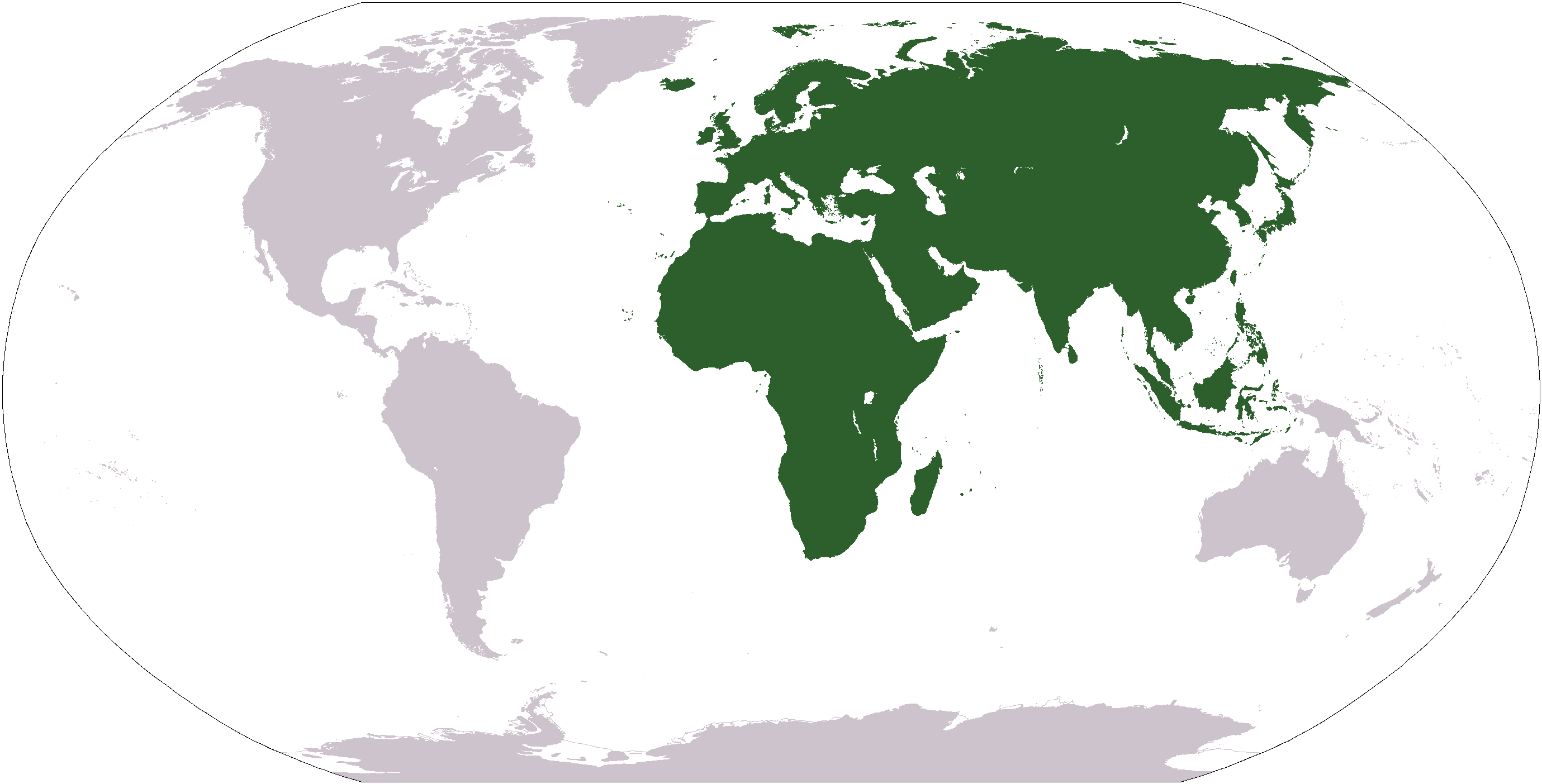
The "Old World" () is a term for Afro-Eurasia that originated in Europe , after Europeans had become aware of the existence of the Americas. It is used to contrast the continents of Africa, Europe, and Asia in the Eastern Hemisphere, previously thought of by their inhabitants as comprising the entire world, with the " New World", a term for the newly encountered lands of the Western Hemisphere, particularly the Americas. While located closer to Afro-Eurasia within the Eastern Hemisphere, Australia is considered neither an Old World nor a New World land, since it was only discovered by Europeans after the distinction had been made; both Australia and Antarctica were associated instead with the '' Terra Australis'' that had been posited as a hypothetical southern continent. Etymology In the context of archaeology and world history, the term "Old World" includes those parts of the world which were in (indirect) cultural contact from the Bronze Age onwards, resulting in ... [...More Info...] [...Related Items...] OR: [Wikipedia] [Google] [Baidu] |
Bronze Age
The Bronze Age is a historic period, lasting approximately from 3300 BC to 1200 BC, characterized by the use of bronze, the presence of writing in some areas, and other early features of urban civilization. The Bronze Age is the second principal period of the three-age system proposed in 1836 by Christian Jürgensen Thomsen for classifying and studying ancient societies and history. An ancient civilization is deemed to be part of the Bronze Age because it either produced bronze by smelting its own copper and alloying it with tin, arsenic, or other metals, or traded other items for bronze from production areas elsewhere. Bronze is harder and more durable than the other metals available at the time, allowing Bronze Age civilizations to gain a technological advantage. While terrestrial iron is naturally abundant, the higher temperature required for smelting, , in addition to the greater difficulty of working with the metal, placed it out of reach of common use until the end o ... [...More Info...] [...Related Items...] OR: [Wikipedia] [Google] [Baidu] |
Iron Age
The Iron Age is the final epoch of the three-age division of the prehistory and protohistory of humanity. It was preceded by the Stone Age (Paleolithic, Mesolithic, Neolithic) and the Bronze Age (Chalcolithic). The concept has been mostly applied to Iron Age Europe and the Ancient Near East, but also, by analogy, to other parts of the Old World. The duration of the Iron Age varies depending on the region under consideration. It is defined by archaeological convention. The "Iron Age" begins locally when the production of iron or steel has advanced to the point where iron tools and weapons replace their bronze equivalents in common use. In the Ancient Near East, this transition took place in the wake of the Bronze Age collapse, in the 12th century BC. The technology soon spread throughout the Mediterranean Basin region and to South Asia (Iron Age in India) between the 12th and 11th century BC. Its further spread to Central Asia, Eastern Europe, and Central Europe is somewhat dela ... [...More Info...] [...Related Items...] OR: [Wikipedia] [Google] [Baidu] |
Silk Road
The Silk Road () was a network of Eurasian trade routes active from the second century BCE until the mid-15th century. Spanning over 6,400 kilometers (4,000 miles), it played a central role in facilitating economic, cultural, political, and religious interactions between the Eastern world, East and Western world, West. The name "Silk Road", first coined in the late 19th century, has fallen into disuse among some modern historians in favor of Silk Routes, on the grounds that it more accurately describes the intricate web of land and sea routes connecting East Asia, East and Southeast Asia, the South Asia, Indian subcontinent, Central Asia, the Middle East, East Africa and Southern Europe, Europe. The Silk Road derives its name from the highly lucrative trade of silk, silk textiles that were Silk industry in China, produced almost exclusively in China. The network began with the Han dynasty, Han dynasty's expansion into Central Asia around 114 BCE, Protectorate of the Western Regio ... [...More Info...] [...Related Items...] OR: [Wikipedia] [Google] [Baidu] |
Sub-Saharan Africa
Sub-Saharan Africa is, geographically, the area and regions of the continent of Africa that lies south of the Sahara. These include West Africa, East Africa, Central Africa, and Southern Africa. Geopolitically, in addition to the List of sovereign states and dependent territories in Africa, African countries and territories that are situated fully in that specified region, the term may also include polities that only have part of their territory located in that region, per the definition of the United Nations (UN). This is considered a non-standardized geographical region with the number of countries included varying from 46 to 48 depending on the organization describing the region (e.g. UN, WHO, World Bank, etc.). The Regions of the African Union, African Union uses a different regional breakdown, recognizing all 55 member states on the continent - grouping them into 5 distinct and standard regions. The term serves as a grouping counterpart to North Africa, which is instead ... [...More Info...] [...Related Items...] OR: [Wikipedia] [Google] [Baidu] |
History Of China
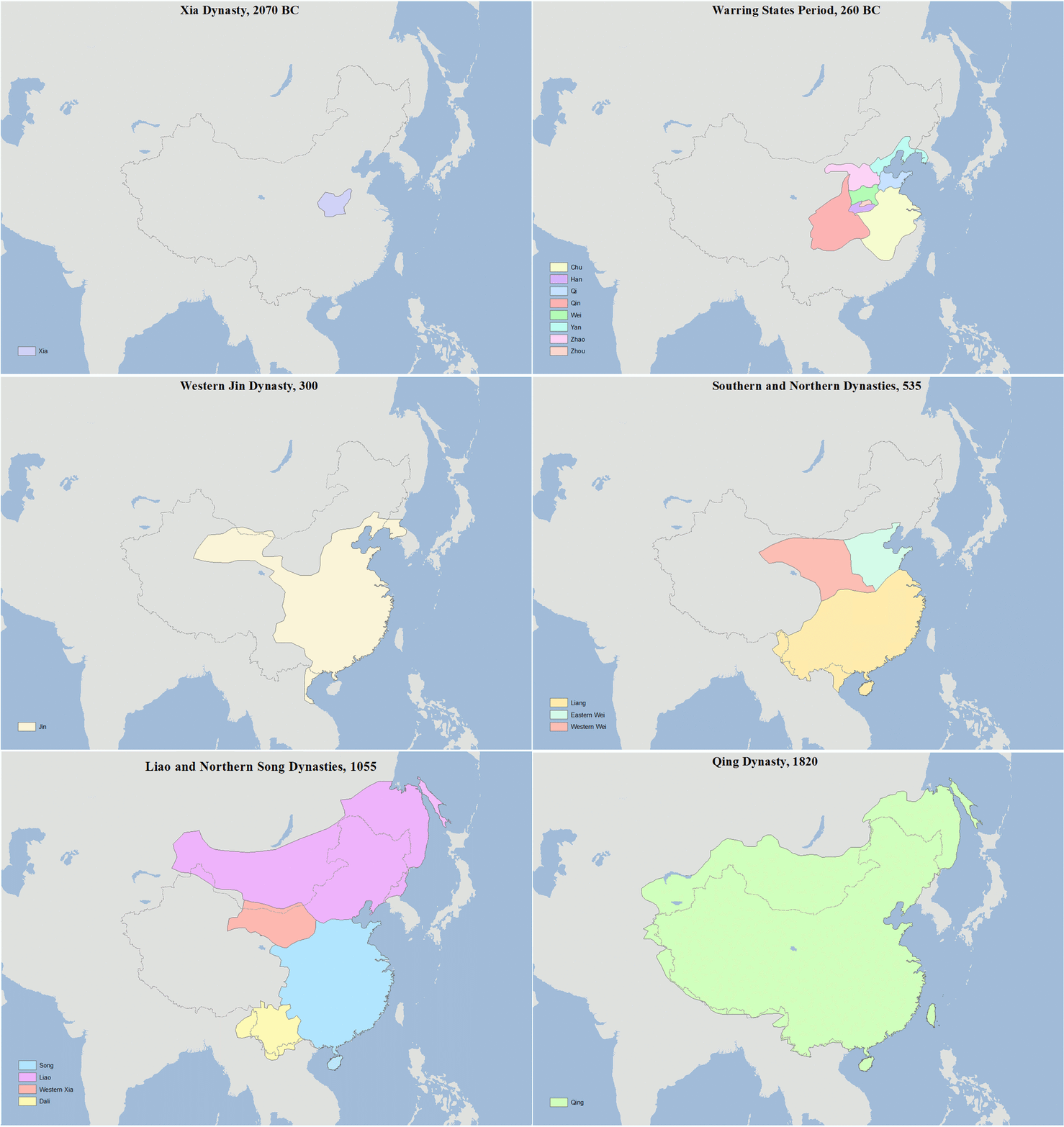
The earliest known written records of the history of China date from as early as 1250 BC, from the Shang dynasty (c. 1600–1046 BC), during the reign of king Wu Ding. Ancient historical texts such as the '' Book of Documents'' (early chapters, 11th century BC), the '' Bamboo Annals'' (c. 296 BC) and the ''Records of the Grand Historian'' (c. 91 BC) describe a Xia dynasty before the Shang, but no writing is known from the period, and Shang writings do not indicate the existence of the Xia. The Shang ruled in the Yellow River valley, which is commonly held to be the cradle of Chinese civilization. However, Neolithic civilizations originated at various cultural centers along both the Yellow River and Yangtze River. These Yellow River and Yangtze civilizations arose millennia before the Shang. With thousands of years of continuous history, China is among the world's oldest civilizations and is regarded as one of the cradles of civilization. The Zhou dynasty (1046–256 BC) supp ... [...More Info...] [...Related Items...] OR: [Wikipedia] [Google] [Baidu] |
Indian Subcontinent
The Indian subcontinent is a list of the physiographic regions of the world, physiographical region in United Nations geoscheme for Asia#Southern Asia, Southern Asia. It is situated on the Indian Plate, projecting southwards into the Indian Ocean from the Himalayas. Geopolitically, it includes the countries of Bangladesh, Bhutan, India, Maldives, Nepal, Pakistan, and Sri Lanka."Indian subcontinent". ''Oxford Dictionary of English, New Oxford Dictionary of English'' () New York: Oxford University Press, 2001; p. 929: "the part of Asia south of the Himalayas which forms a peninsula extending into the Indian Ocean, between the Arabian Sea and the Bay of Bengal. Historically forming the whole territory of Greater India, the region is now divided into three countries named Bangladesh, India and Pakistan." The terms ''Indian subcontinent'' and ''South Asia'' are often used interchangeably to denote the region, although the geopolitical term of South Asia frequently includes Afghanist ... [...More Info...] [...Related Items...] OR: [Wikipedia] [Google] [Baidu] |
Iranian Plateau
The Iranian plateau or Persian plateau is a geological feature in Western Asia, Central Asia, and South Asia. It comprises part of the Eurasian Plate and is wedged between the Arabian Plate and the Indian Plate; situated between the Zagros Mountains to the west, the Caspian Sea and the Köpet Dag to the north, the Armenian Highlands and the Caucasus Mountains to the northwest, the Strait of Hormuz and the Persian Gulf to the south, and the Indian subcontinent to the east. As a historical region, it includes Parthia, Media, Persis, and some of the previous territories of Greater Iran."Old Iranian Online" University of Texas College of Liberal Arts (retrieved 10 February 2007) The Zagros form the plateau's western boundary, and its eastern slopes may also be included in the term. The '' |
Mesopotamia
Mesopotamia ''Mesopotamíā''; ar, بِلَاد ٱلرَّافِدَيْن or ; syc, ܐܪܡ ܢܗܪ̈ܝܢ, or , ) is a historical region of Western Asia situated within the Tigris–Euphrates river system, in the northern part of the Fertile Crescent. Today, Mesopotamia occupies modern Iraq. In the broader sense, the historical region included present-day Iraq and Kuwait and parts of present-day Iran, Syria and Turkey. The Sumerians and Akkadians (including Assyrians and Babylonians) originating from different areas in present-day Iraq, dominated Mesopotamia from the beginning of written history () to the fall of Babylon in 539 BC, when it was conquered by the Achaemenid Empire. It fell to Alexander the Great in 332 BC, and after his death, it became part of the Greek Seleucid Empire. Later the Arameans dominated major parts of Mesopotamia (). Mesopotamia is the site of the earliest developments of the Neolithic Revolution from around 10,000 BC. It has been identi ... [...More Info...] [...Related Items...] OR: [Wikipedia] [Google] [Baidu] |
North Africa
North Africa, or Northern Africa is a region encompassing the northern portion of the African continent. There is no singularly accepted scope for the region, and it is sometimes defined as stretching from the Atlantic shores of Mauritania in the west, to Egypt's Suez Canal. Varying sources limit it to the countries of Algeria, Libya, Morocco, and Tunisia, a region that was known by the French during colonial times as "''Afrique du Nord''" and is known by Arabs as the Maghreb ("West", ''The western part of Arab World''). The United Nations definition includes Morocco, Algeria, Tunisia, Libya, Egypt, Sudan, and the Western Sahara, the territory disputed between Morocco and the Sahrawi Republic. The African Union definition includes the Western Sahara and Mauritania but not Sudan. When used in the term Middle East and North Africa (MENA), it often refers only to the countries of the Maghreb. North Africa includes the Spanish cities of Ceuta and Melilla, and plazas de s ... [...More Info...] [...Related Items...] OR: [Wikipedia] [Google] [Baidu] |
History Of The Mediterranean Region
The history of the Mediterranean region and of the cultures and people of the Mediterranean Basin is important for understanding the origin and development of the Mesopotamian, Egyptian, Canaanite, Phoenician, Hebrew, Carthaginian, Minoan, Greek, Persian, Illyrian, Thracian, Etruscan, Iberian, Roman, Byzantine, Bulgarian, Arab, Berber, Ottoman, Christian and Islamic cultures. The Mediterranean Sea was the central superhighway of transport, trade and cultural exchange between diverse peoples encompassing three continents: Western Asia, North Africa, and Southern Europe. Early history Lézignan-la-Cèbe in France, Orce in Spain, Monte PoggioloNational Geographic Italia – Erano padani i primi abitanti d’Italia ... [...More Info...] [...Related Items...] OR: [Wikipedia] [Google] [Baidu] |
25th Parallel North
The 25th parallel north is a circle of latitude that is 25 degrees north of the Earth's equatorial plane. It crosses Africa, Asia, the Indian Ocean, the Pacific Ocean, North America and the Atlantic Ocean. The northernmost section of the border between Mauritania and Mali is defined by the parallel. At this latitude the sun is visible for 13 hours, 42 minutes during the summer solstice and 10 hours, 35 minutes during the winter solstice. Around the world Starting at the Prime Meridian and heading eastwards, the parallel 25° north passes through: : See also *24th parallel north The 24th parallel north is a circle of latitude that is 24 degrees north of the Earth's equatorial plane, about north of the Tropic of Cancer. It is the line which demarcates boundary between Pakistan and India in the general area of Rann of K ... * 26th parallel north References {{geographical coordinates, state=collapsed n25 Mali–Mauritania border ... [...More Info...] [...Related Items...] OR: [Wikipedia] [Google] [Baidu] |


