|
Oberstdorf
Oberstdorf ( Low Alemannic: ''Oberschdorf'') is a municipality and skiing and hiking town in Germany, located in the Allgäu region of the Bavarian Alps. It is the southernmost settlement in Germany and one of its highest towns. At the center of Oberstdorf is a church whose tall spire serves as a landmark for navigating around town. The summits of the Nebelhorn and Fellhorn provide dramatic panoramic views of the alps. The Nebelhorn can be reached with a big cable car. Visitors can ride a unique diagonal elevator to the top of the Heini-Klopfer-Skiflugschanze. Geography Administrative divisions Oberstdorf consists of the village of Oberstdorf (813 metres above sea level, survey point by the Roman Catholic church) and five other villages: * ''Kornau'' , 915 m. In the vicinity is the Söllereckbahn and the Chapel of St. Fabian and St. Sebastian which is rich in art treasures. * In ''Reichenbach'' (population: 226) is the 450-year-old Chapel of St. James and ... [...More Info...] [...Related Items...] OR: [Wikipedia] [Google] [Baidu] |
Oberstdorf View
Oberstdorf (Low Alemannic: ''Oberschdorf'') is a municipality and skiing and hiking town in Germany, located in the Allgäu region of the Bavarian Alps. It is the southernmost settlement in Germany and one of its highest towns. At the center of Oberstdorf is a church whose tall spire serves as a landmark for navigating around town. The summits of the Nebelhorn and Fellhorn provide dramatic panoramic views of the alps. The Nebelhorn can be reached with a big cable car. Visitors can ride a unique diagonal elevator to the top of the Heini-Klopfer-Skiflugschanze. Geography Administrative divisions Oberstdorf consists of the village of Oberstdorf (813 metres above sea level, survey point by the Roman Catholic church) and five other villages: * ''Kornau'' , 915 m. In the vicinity is the Söllereckbahn and the Chapel of St. Fabian and St. Sebastian which is rich in art treasures. * In ''Reichenbach'' (population: 226) is the 450-year-old Chapel of St. James and th ... [...More Info...] [...Related Items...] OR: [Wikipedia] [Google] [Baidu] |
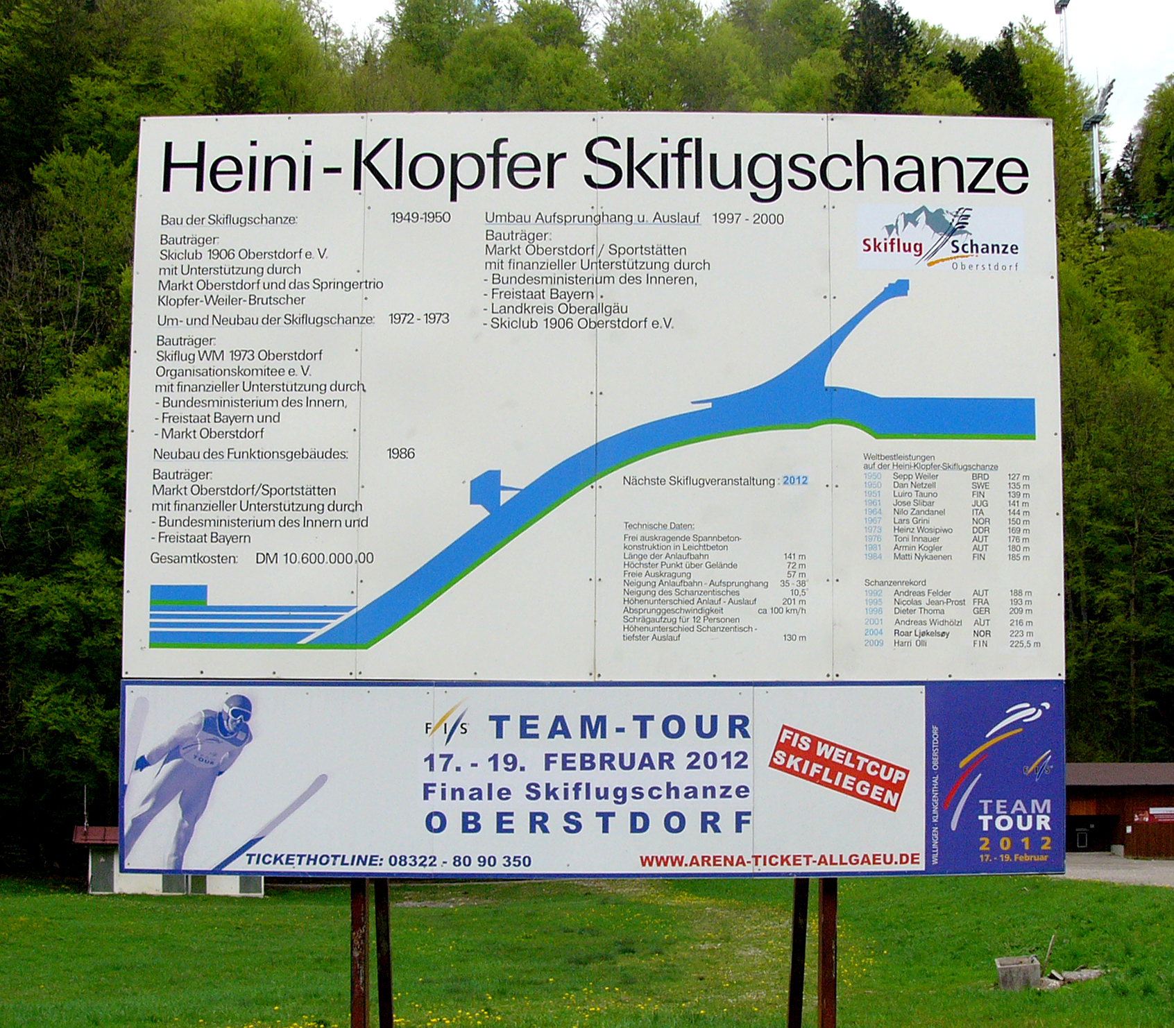
Heini-Klopfer-Skiflugschanze
Heini-Klopfer-Skiflugschanze (''Heini Klopfer Ski Flying Hill'') is a ski flying hill in Oberstdorf, Germany. It was opened in 1950, and was later renamed after its architect, Heini Klopfer. A total of 21 world records have been set on the hill. The venue should not be confused with the Schattenberg ski jumping hill, also in Oberstdorf, about to the north. History 1949: Plans and realisation In 1949, they were originally discussing about whether they should just rather enlarge the existing Schattenbergschanze or build a complete new hill with calculation point at K120. Three ski jumpers Heini Klopfer, Sepp Weiler and Toni Brutscher together made a final decision to build a complete new hill and they found the perfect location. Inspired by Planica, the wanted to beat legendary Bloudkova velikanka in Slovenia, as the long time world record breaking and leading hill. Starting in July, hill construction was completed as planned in only five months, finished on 10 December. ... [...More Info...] [...Related Items...] OR: [Wikipedia] [Google] [Baidu] |
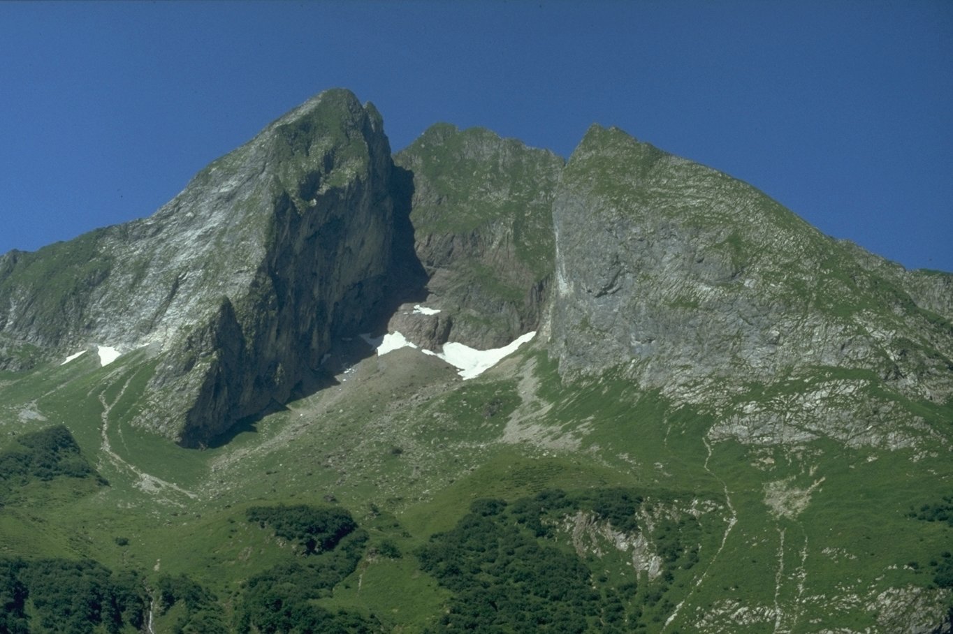
Höfats
The Höfats is a 2,259 m high mountain in the Allgäu Alps. Located near Oberstdorf, it separates the Oy and the Dietersbach valleys, along with the Rauheck and other lower summits. With its very steep faces it is the most striking of the Allgau " grass mountains" (''Grasberge'') and is unique in the Eastern Alps. It may be compared to the mountains of the Lofoten. Location and surrounding area The Höfats has four almost equally high and narrow summits, whose appearance has been said in the past to resemble that of a Gothic cathedral.Ernst Zettler/Heinz Groth: ''Alpenvereinsführer Allgäuer Alpen''. Munich, Bergverlag Rudolf Rother 1951, p. 214 The four summits of the Höfats divide into two pairs of peaks that are separated by the Höfats wind gap (''Höfatsscharte'', 2207 m). Between the summits of the two pairs of peaks are smaller gaps (about 2233 m and 2227 m high). All of the peaks sit on the crest of a ridge that runs from Rauheck towards the northwest.Ernst Zet ... [...More Info...] [...Related Items...] OR: [Wikipedia] [Google] [Baidu] |
Starzlach (Breitach)
Starzlach is a river in the Allgäu region of the Bavarian Alps. Located in the Northwest of (part of Oberstdorf) and west of Oberstdorf itself it flows into the river Breitach. Its main tributaries are Hörnlegraben and Letzenbach. See also *List of rivers of Bavaria A list of rivers of Bavaria, Germany: A * Aalbach *Abens * Ach * Afferbach * Affinger Bach * Ailsbach *Aisch * Aiterach *Alpbach *Alster * Altmühl *Alz * Amper * Anlauter * Arbach * Arbachgraben *Aschaff * Aschbach * Attel * Aubach, tributary of ... References Rivers of Bavaria Rivers of Germany {{Bavaria-river-stub ... [...More Info...] [...Related Items...] OR: [Wikipedia] [Google] [Baidu] |
Breitach
The Breitach is a mountain river, the southwestern (left) source of the Iller in the Allgäu Alps, in the states of Vorarlberg (Austria) and Bavaria (Germany). Detail The river originates in , a part of Mittelberg, in the Kleinwalsertal as the union of three smaller source streams. It flows in the northwestern direction through the valley that in earlier times was called ("Breitach Valley") after the river. At the , the Austrian-German border, the Breitach reaches German territory and curves through the narrow Breitachklamm. Then, the Starzlach flows from the west into the Breitach. At the so-called ("Iller origin") in Oberstdorf, the Breitach, the Stillach and the Trettach Trettach is a river of Bavaria, Germany. At its confluence with the Breitach and the Stillach in Oberstdorf, the Iller is formed. See also *List of rivers of Bavaria A list of rivers of Bavaria, Germany: A * Aalbach * Abens * Ach * Afferbach ... flow together forming the Iller. Of geological interes ... [...More Info...] [...Related Items...] OR: [Wikipedia] [Google] [Baidu] |
Oybach
The Oybach is a river of Bavaria, Germany. It flows into the Trettach south of Oberstdorf. See also *List of rivers of Bavaria References Rivers of Bavaria Rivers of Germany {{Bavaria-river-stub ... [...More Info...] [...Related Items...] OR: [Wikipedia] [Google] [Baidu] |
Tiefenbach (Oberstdorf)
Tiefenbach may refer to: Places Austria * Tiefenbach bei Kaindorf, a former municipality in the district of Hartberg-Fürstenfeld in Styria, today part of Hartl *Tiefenbach, a township of the municipality of Judenburg in Styria Czech Republic *Tiefenbach, a historical exonym for Hloubětín Germany *Tiefenbach, Biberach, a municipality in Baden-Württemberg, in the district of Biberach * Tiefenbach, Landshut, a municipality in Bavaria, in the district of Landshut * Tiefenbach, Passau, a municipality in Bavaria, in the district of Passau *Tiefenbach, Rhineland-Palatinate, a municipality in the district of Rhein-Hunsrück *Tiefenbach, Saxony, a municipality in the district of Mittweida * Tiefenbach, Upper Palatinate, a municipality in Bavaria, in the district of Cham *Tiefenbach (Jagst), a river of Baden-Württemberg, tributary of the Jagst * Tiefenbach (Rems), a river of Baden-Württemberg, tributary of the Rems *Tiefenbach (Wisper), a river of Rhineland-Palatinate and Hesse, tribu ... [...More Info...] [...Related Items...] OR: [Wikipedia] [Google] [Baidu] |
Rauheck
Rauheck is a mountain of Bavaria, Germany. Climbing routes Four paths lead to the summit: *via the Oytal over the Älplesattel, *via the Dietersbachtal, also over the Älplesattel, *via the Eissee The Upper and Lower Eissee are two lakes in the Dachstein Mountains in the Austrian state of Upper Austria. They lie north of a 2,794 m high mountain, the Gjaidstein, at an elevation of around . Lower Eissee The Lower Eissee (german: Unter ... above the Käseralp and *via the Kreuzeck. References Mountains of Bavaria Allgäu Alps Mountains of the Alps {{Bavaria-geo-stub ... [...More Info...] [...Related Items...] OR: [Wikipedia] [Google] [Baidu] |
Nebelhorn
The Nebelhorn is a mountain in the Allgäu Alps in Germany, near the village of Oberstdorf. It lends its name to the Nebelhorn Trophy figure skating competition and the Nebelhorn Classics a freeride race event. Also the Nine Knights freeski contest takes place just above the "Höfatsblick" station of the Nebelhornbahn. Its summit is a well-known viewing point, from where there is a view far into the Alpine massif. The summit area of the Nebelhorn may be climbed via the Hindelang Klettersteig; it should only be attempted with special equipment (a 'Klettersteig set'). Gallery File:Nebelhorn summit.jpg, Summit File:Nebelhorn ansicht.JPG, View from Edmund-Probst-Haus to the Nebelhorn File:Geissfuss und Nebelhorn.jpg, Nebelhorn from Schattenberg File:Nebelhorn gipfel 2008-12-30.jpg, Paragliders File:Nebelhorn Höfatsblick.jpg, Station Hofätsblick File:Nebelhorn Höfatsblick u Gipfelstation.jpg, Stations Hofätsblick and Gipfelstation File:Nebelhorn-vom-riedberger-horn.jpg, N ... [...More Info...] [...Related Items...] OR: [Wikipedia] [Google] [Baidu] |
Fellhorn
The Fellhorn () is a mountain in the " Allgäu Alps" near Oberstdorf, Germany, on the border with Austria. It is known for its fields of alpenroses ( Rhododendron ferrugineum). According to Austrian sources the mountain is . Access In 1972, a gondola lift, the " Fellhorn Lift", was built that runs up the mountain from the Stillach valley. Its top station is at 1,967 metres. There is also a lift connection to the Kanzelwandbahn. The cross-border Fellhorn/ Kanzelwand Ski Region has 24 kilometres of slopes In mathematics, the slope or gradient of a line is a number that describes both the ''direction'' and the ''steepness'' of the line. Slope is often denoted by the letter ''m''; there is no clear answer to the question why the letter ''m'' is used ... and 14 lifts. retrieved 5 April 2012 ... [...More Info...] [...Related Items...] OR: [Wikipedia] [Google] [Baidu] |
Iller
The Iller (; ancient name Ilargus) is a river of Bavaria and Baden-Württemberg in Germany. It is a right tributary of the Danube, long. It is formed at the confluence of the rivers Breitach, Stillach and Trettach near Oberstdorf in the Allgäu region of the Alps, close to the Austrian border. From there it runs northwards, passing the towns of Sonthofen, Immenstadt, and Kempten. Between Lautrach near Memmingen and Ulm it forms the border between the two German States Bavaria and Baden-Württemberg for about . The river flows into the Danube in the city centre of Ulm. The Iller has a catchment area of . It ranks as the seventh of Bavaria's rivers by water flow, with an average throughput of at Senden, a short distance upstream from the Danube. The power of the river is used for the production of hydroelectricity via eight power stations with a total net capacity of 51 MW (1998). A bicycle route follows the Iller, which is also a popular location for rafting and trekking. ... [...More Info...] [...Related Items...] OR: [Wikipedia] [Google] [Baidu] |
Nebelhorn Oberstdorf
The Nebelhorn is a mountain in the Allgäu Alps in Germany, near the village of Oberstdorf. It lends its name to the Nebelhorn Trophy figure skating competition and the Nebelhorn Classics a freeride race event. Also the Nine Knights freeski contest takes place just above the "Höfatsblick" station of the Nebelhornbahn. Its summit is a well-known viewing point, from where there is a view far into the Alpine massif. The summit area of the Nebelhorn may be climbed via the Hindelang Klettersteig; it should only be attempted with special equipment (a 'Klettersteig set'). Gallery File:Nebelhorn summit.jpg, Summit File:Nebelhorn ansicht.JPG, View from Edmund-Probst-Haus to the Nebelhorn File:Geissfuss und Nebelhorn.jpg, Nebelhorn from Schattenberg File:Nebelhorn gipfel 2008-12-30.jpg, Paragliders File:Nebelhorn Höfatsblick.jpg, Station Hofätsblick File:Nebelhorn Höfatsblick u Gipfelstation.jpg, Stations Hofätsblick and Gipfelstation File:Nebelhorn-vom-riedberger-horn.jpg, N ... [...More Info...] [...Related Items...] OR: [Wikipedia] [Google] [Baidu] |


