|
Novempopulana
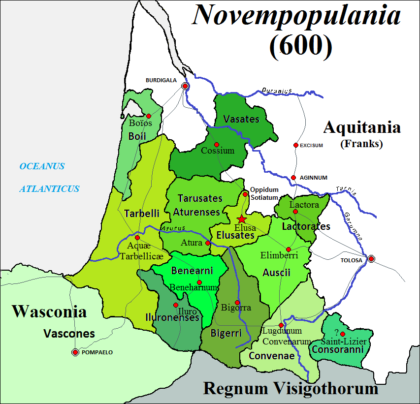
Novempopulania (Latin for "country of the nine peoples") was one of the provinces created by Diocletian (Roman emperor from 284 to 305) out of Gallia Aquitania, which was also called ''Aquitania Tertia''. Early Roman period The area of Novempopulania was first named '' Aquitania'', as it was where the Aquitani dwelt. The territory extended within the triangular area outlined by the River Garonne, the Pyrenees and the Bay of Biscay, as described by Julius Caesar in his ''Commentarii de Bello Gallico'' for Gallia Aquitania. In his work, Caesar describes the Aquitania as being different in language and body make-up from their northerly neighbours and more similar to the Celtiberians. The province of Aquitania was enlarged by Augustus, and it began to signify a larger and more diverse territory. Late antiquity The name Novempopulania stands for the nine peoples making up the original territory (Aquitania Tertia). It seems clear that at the time of the lower empire (2nd to 4th c ... [...More Info...] [...Related Items...] OR: [Wikipedia] [Google] [Baidu] |
Couserans
image:Blason province fr Couserans.svg, 125px, Coat of arms of CouseransCouserans (; Gascon language, Gascon: ''Coserans'' ) is a small former province of France located in the Pyrenees mountains. Today Couserans makes up the western half of the Ariège (department), Ariège ''département in France, département'', around the towns of Saint-Girons, Ariège, Saint-Girons and Saint-Lizier. A small part of Couserans is also in the extreme south of Haute-Garonne, just across the border from Ariège. Couserans has a land area of 1,162 km² (449 sq. miles). At the 1999 census there were 21,260 inhabitants on the territory of the former province of Couserans, which means a density of only 18 inhabitants per km² (47 inhabitants per sq. mile), one of the lowest densities in western Europe. The only urban area is Saint-Girons (which includes Saint-Lizier), with 9,484 inhabitants in 1999 (44.6% of the whole population of Couserans). History Antiquity Couserans was inhabited by a peopl ... [...More Info...] [...Related Items...] OR: [Wikipedia] [Google] [Baidu] |
Auch
Auch (; oc, label= Gascon, Aush ) is a commune in southwestern France. Located in the region of Occitanie, it is the capital of the Gers department. Auch is the historical capital of Gascony. Geography Localization Hydrography The River Gers flows through the town. Transportation Auch is well connected to nearby cities and towns such as Agen, Toulouse and Tarbes by Routes Nationales and by train to Toulouse. Climate History and population Auch is a very ancient town, whose settlement was noted by the Romans during their conquest of the area in the . At that time, it was settled by an Aquitanian tribe known to the Romans as the Ausci. Their name for the town was Climberrum" or Elimberris. This has been tentatively etymologized from the Iberian ''iltir'' ("town, oppidum") and a cognate of the Basque ''berri'' ("new"), although another Iberian settlement in Granada recorded by the Romans as "Iliberi" probably had no contact with proto-Basque speaking peoples ... [...More Info...] [...Related Items...] OR: [Wikipedia] [Google] [Baidu] |
Hasparren
Hasparren (; eu, Hazparne) is a commune in the Pyrénées-Atlantiques department in south-western France. A resident of Hasparren is known as a 'Hazpandar'. Geography Location It's a ''commune fait partie'' of the Basque Province of Labourd. The Côte Basque (''Euskal Kostaldea)'', is 25 km to the west. Access Hasparren is located on the route D 10, between La Bastide-Clairence and Cambo-les-Bains, at the crossroads with D 21, D 22 and D 23. It has got access to autoroute A 64, exit 4 near Briscous. Hydrography The rivers Ardanabia and Suhihandia (a tributary of the Aran), flow through the commune. Locations Eight settlements compose the Commune of Hasparren: * Labiri ; * Elizaberri ; * la Coste (la Côte sur les cartes IGN) ; * Peña (Pegna sur les cartes IGN) ; * Minhotz ; * la Ville ; * Urcuray ; * Bas-Labiri et Zelhaia . Toponymy Ancient attestations It is attestested with various words: ''Hesperenne'' (1247 in Cartulaire de Bayonne) ''Sant ... [...More Info...] [...Related Items...] OR: [Wikipedia] [Google] [Baidu] |
Oloron
Oloron-Sainte-Marie (; oc, Auloron e Senta Maria; eu, Oloroe-Donamaria) is a commune in the Pyrénées-Atlantiques department, region of Nouvelle-Aquitaine (before 2015: Aquitaine), southwestern France. History The town was founded by the Romans in the 1st century, then known as ''Illoronensium''. Situated on the Roman way between the important towns of Dax and Saragossa, its position was strategic. Today known as Saint-Great, Gratus of Oloron became in 506 the first known archbishop of the Ancient Diocese of Oloron then known as "Iluro". The history of the town during the Migration Period is little known. In 1080, the viscount Centule V, Viscount of Béarn built the new city of "Oloron" (medieval version of the Roman name Iluro) on the opposite side of the river from the diocese center. Centule V restored the Roman walls and founded the strong city of Oloron that was to be used as a base to retake Aragon held by the Moors. The Oloron Cathedral was built at the beginning of ... [...More Info...] [...Related Items...] OR: [Wikipedia] [Google] [Baidu] |
Tarbes
Tarbes (; Gascon: ''Tarba'') is a commune in the Hautes-Pyrénées department in the Occitanie region of southwestern France. It is the capital of Bigorre and of the Hautes-Pyrénées. It has been a commune since 1790. It was known as ''Turba'' or ''Tarba'' in Roman times. Tarbes is part of the historical region of Gascony. Formerly of strong industrial tradition, Tarbes today tries to diversify its activities, particularly in aeronautics and high tech around the different zones of activities which are increasing. The recent development of and other regional specialties also shows a willingness to develop the agri-food industry thus justifying its nickname of "market town". Its 42,888 inhabitants are called ''Tarbaises'' and the ''Tarbais''. It is the seat of the diocese of Tarbes-et-Lourdes. The 1st Parachute Hussar Regiment and 35th Parachute Artillery Regiment are stationed in Tarbes. Geography Location Tarbes is a Pre-Pyrenees town within the rich agricultural plai ... [...More Info...] [...Related Items...] OR: [Wikipedia] [Google] [Baidu] |
Bazas
Bazas (; oc-gsc, Vasats) is a commune in the Gironde department in southwestern France. Geography Bazas stands on a narrow promontory above the Beuve valley 60 km/37 mi southeast of Bordeaux and 40 km/25 mi southwest of Marmande. History As ''Cossio'', it was capital of the ancient tribe of the ''Vasates'', and under the Romans one of the twelve cities of Novempopulania, when it was known as ''Civitas Vasatica'' In later times it was capital of the district of Bazadais, and was the seat of the bishop of the diocese of Bazas from at least the beginning of the 6th century until 1790. And for 250 years prior to 1057, the Bishop of Bazas bore the title of Bishop of Aire, Dax, Bayonne, Oloron and Lescar. According to Gregory of Tours, Bazas had a bishop at the time of the Vandal invasion in the 5th century. The dedication of the cathedral to St. John the Baptist is explained in an account given by the same historian that a lady of Bazas, whom certain hag ... [...More Info...] [...Related Items...] OR: [Wikipedia] [Google] [Baidu] |
Aire-sur-l'Adour
Aire-sur-l'Adour (; oc, Aira d'Ador or simply ) is a commune in the Landes department, Nouvelle-Aquitaine, southwestern France. It lies on the river Adour in the wine area of southwest France. It is an episcopal see of the Diocese of Aire and Dax. The nearest large towns are Mont-de-Marsan to the north and Pau to the south. History Aire (''Atura'', ''Vicus Julii'') once was the residence of the kings of the Visigoths. Here in 506 Alaric II drew up his code, the ''Breviarium Alaricianum''. Famed bullfighter Iván Fandiño died in Aire-sur-l'Adour after being gored by a bull on 17 June 2017. Sights *Aire Cathedral, built in the 11th century but renovated in the 14th and 17th centuries. *The Gothic church of ''Sainte-Quitterie'' is dedicated to Saint Quiteria, who, according to Christian tradition, was beheaded here in the fifth century. This church is on the pilgrimage route called the Way of St. James. Population Personalities * Pierrette Le Pen, mother of Marine Le Pen ... [...More Info...] [...Related Items...] OR: [Wikipedia] [Google] [Baidu] |
Lescar
Lescar (; oc, Lescar) is a commune in the Pyrénées-Atlantiques department and Nouvelle-Aquitaine region of south-western France. Lescar is the site of the Roman city known variously as Benearnum, Beneharnum or Civitas Benarnensium, the location providing the name for the later region of Béarn. In 841, Benearnum was razed by the Vikings and Morlaàs became the Béarnaise capital. However, from the twelfth century a new city grew up at Lescar. Lescar Cathedral was built during this period, and was the seat of the Diocese of Lescar until 1801. The remains of the last monarchs of all Navarre Queen Catherine I (†1517) and King John III (†1516) lie at the cathedral. Today, Lescar is primarily a suburb of the nearby town of Pau. The commune of Lescar has joined together with 30 neighbouring communes to establish the Communauté d'agglomération Pau Béarn Pyrénées which provides a framework within which local tasks are carried out together. Population Twin towns * L' ... [...More Info...] [...Related Items...] OR: [Wikipedia] [Google] [Baidu] |
Béarn
The Béarn (; ; oc, Bearn or ''Biarn''; eu, Bearno or ''Biarno''; or ''Bearnia'') is one of the traditional provinces of France, located in the Pyrenees mountains and in the plain at their feet, in southwest France. Along with the three Basque provinces of Soule, Lower Navarre, and Labourd, the Principality of Bidache, as well as small parts of Gascony, it forms in the southwest the current ''département'' of Pyrénées-Atlantiques (64). The capitals of Béarn were Beneharnum (until 841), Morlaàs (from ca. 1100), Orthez (from the second half of the 13th century), and then Pau (beginning in the mid-15th century). Béarn is bordered by Basque provinces Soule and Lower Navarre to the west, by Gascony ( Landes and Armagnac) to the north, by Bigorre to the east, and by Spain (Aragon) to the south. Today, the mainstays of the Béarn area are the petroleum industry, the aerospace industry through the helicopter turboshaft engine manufacturer Turbomeca, tourism and agriculture ... [...More Info...] [...Related Items...] OR: [Wikipedia] [Google] [Baidu] |
Pays De Born
In France, a ''pays'' () is an area whose inhabitants share common geographical, economic, cultural, or social interests, who have a right to enter into communal planning contracts under a law known as the Loi Pasqua or LOADT (''Loi d'Orientation pour l'Aménagement et le Développement du Territoire''; en, Directive law concerning territorial planning and development), which took effect on February 4, 1995. It was augmented on June 25, 1999, by the Loi Voynet or LOADDT (''Loi d'Orientation de l'Aménagement Durable du Territoire''). The LOADDT enables the citizens of a community to form a legally recognized ''pays'' after deciding to do so by mutual consent; its aim is to help bring the inhabitants of urban and neighboring rural districts into dialogue and agreement. The Council of Development in each ''pays'' assembles together the elected officials and the economic, social, and cultural actors, and their associates, into a deliberative forum to discuss the development polici ... [...More Info...] [...Related Items...] OR: [Wikipedia] [Google] [Baidu] |
La Teste-de-Buch
La Teste-de-Buch (; oc, La Tèsta (de Bug) ) is a commune in the Gironde department, Nouvelle-Aquitaine, Southwestern France. It is located on the south shore of Arcachon Bay, lying in the southwestern part of Gironde. It is the largest of four communes that comprise the Communauté d'agglomération Bassin d'Arcachon Sud (COBAS), which coincides with the urban unit (agglomeration) of La Teste-de-Buch-Arcachon, population 67,563 (2018). INSEE It is the eighth-largest commune in in geographical area. La Teste-de-Buch is famous for the Dune du Pi ... [...More Info...] [...Related Items...] OR: [Wikipedia] [Google] [Baidu] |


