|
North Pacific High
The North Pacific High is a semi-permanent, subtropical anticyclone located in the northeastern portion of the Pacific Ocean, located northeast of Hawaii and west of California. It is strongest during the northern hemisphere summer and shifts towards the equator during the winter, when the Aleutian Low becomes more active. It is responsible for California's typically dry summer and fall and typically wet winter and spring, as well as Hawaii's year-round trade winds. During the 2011–2017 California drought, the North Pacific High persisted longer than usual, due to a mass of warm water in the Pacific Ocean, resulting in the Ridiculously Resilient Ridge. This significantly limited the number of powerful winter storms that were able to reach California, resulting in historic drought conditions in that state for several years. See also * South Pacific High * North Pacific Current * California Current * El Niño–Southern Oscillation El Niño–Southern Oscillation (ENSO) is ... [...More Info...] [...Related Items...] OR: [Wikipedia] [Google] [Baidu] |
Trade Winds
The trade winds or easterlies are the permanent east-to-west prevailing winds that flow in the Earth's equatorial region. The trade winds blow mainly from the northeast in the Northern Hemisphere and from the southeast in the Southern Hemisphere, strengthening during the winter and when the Arctic oscillation is in its warm phase. Trade winds have been used by captains of sailing ships to cross the world's oceans for centuries. They enabled colonial expansion into the Americas, and trade routes to become established across the Atlantic Ocean and the Pacific Ocean. In meteorology, they act as the steering flow for tropical storms that form over the Atlantic, Pacific, and southern Indian oceans and make landfall in North America, Southeast Asia, and Madagascar and East Africa. Shallow cumulus clouds are seen within trade wind regimes and are capped from becoming taller by a trade wind inversion, which is caused by descending air aloft from within the subtropical ridge. The weak ... [...More Info...] [...Related Items...] OR: [Wikipedia] [Google] [Baidu] |
El Niño–Southern Oscillation
El Niño–Southern Oscillation (ENSO) is an irregular periodic variation in winds and sea surface temperatures over the tropical eastern Pacific Ocean, affecting the climate of much of the tropics and subtropics. The warming phase of the sea temperature is known as ''El Niño'' and the cooling phase as ''La Niña''. The ''Southern Oscillation'' is the accompanying atmospheric component, coupled with the sea temperature change: ''El Niño'' is accompanied by high air surface pressure in the tropical western Pacific and ''La Niña'' with low air surface pressure there. The two periods last several months each and typically occur every few years with varying intensity per period. The two phases relate to the Walker circulation, which was discovered by Gilbert Walker during the early twentieth century. The Walker circulation is caused by the pressure gradient force that results from a high-pressure area over the eastern Pacific Ocean, and a low-pressure system over Indonesia. Weak ... [...More Info...] [...Related Items...] OR: [Wikipedia] [Google] [Baidu] |
California Current
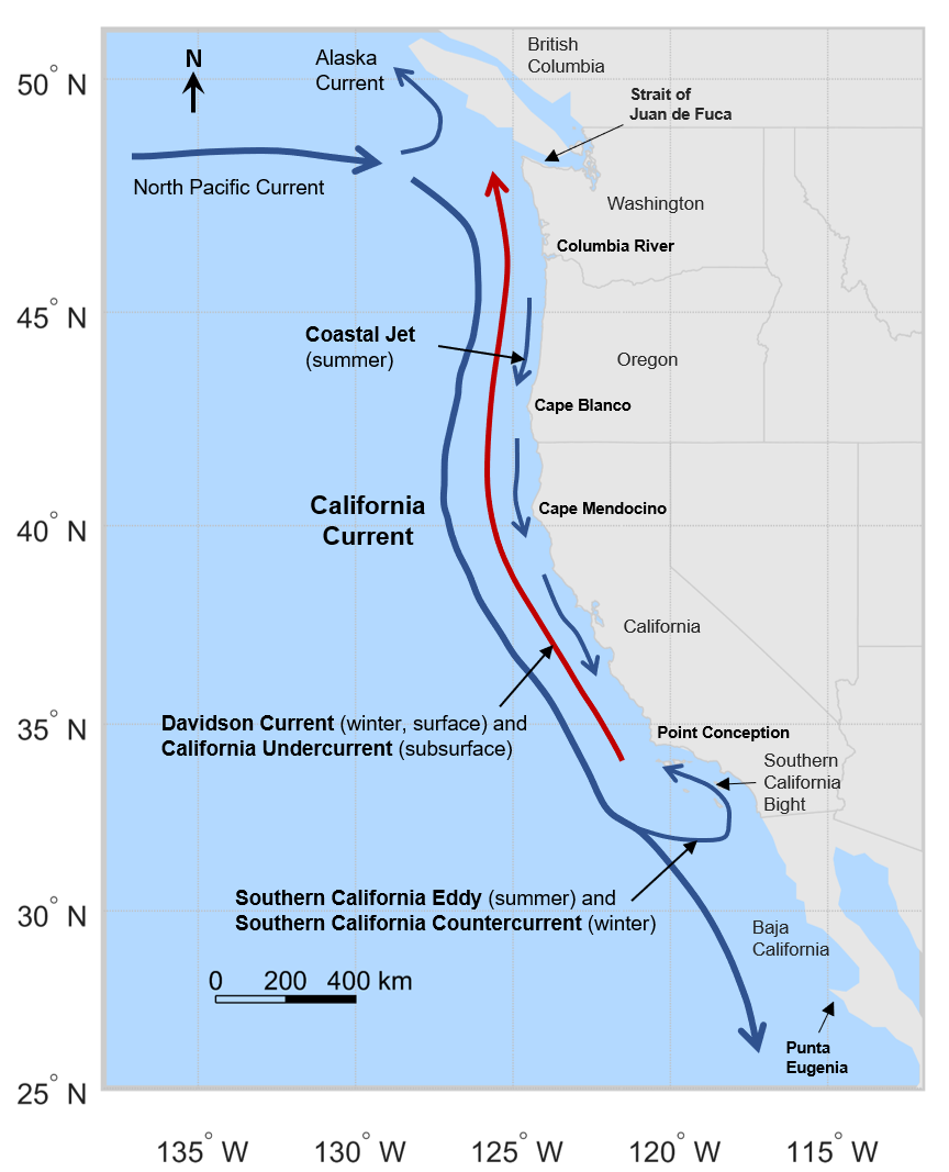
The California Current is a cold water Pacific Ocean current that moves southward along the western coast of North America, beginning off southern British Columbia and ending off southern Baja California Sur. It is considered an Eastern boundary current due to the influence of the North American coastline on its course. It is also one of five major coastal currents affiliated with strong upwelling zones, the others being the Humboldt Current, the Canary Current, the Benguela Current, and the Somali Current. The California Current is part of the North Pacific Gyre, a large swirling current that occupies the northern basin of the Pacific. Physical properties The movement of Alaskan and northern ocean currents southward down the west coast results in much cooler ocean temperatures than at comparable latitudes on the east coast of the United States, where ocean currents come from the Caribbean and tropical Atlantic. The cooler ocean current along the west coast also makes summer ... [...More Info...] [...Related Items...] OR: [Wikipedia] [Google] [Baidu] |
North Pacific Current
The North Pacific Current (sometimes referred to as the North Pacific Drift) is a slow warm water current that flows west-to-east between 30 and 50 degrees north in the Pacific Ocean. The current forms the southern part of the North Pacific Subpolar Gyre and the northern part of the North Pacific Subtropical Gyre. The North Pacific Current is formed by the collision of the Kuroshio Current, running northward off the coast of Japan, and the Oyashio Current, which is a cold subarctic current that flows south and circulates counterclockwise along the western North Pacific Ocean. In the eastern North Pacific off southern British Columbia, it splits into the southward flowing cold water California Current and the northward flowing Alaska Current. Flows and temperature Originating from the eastward directed flow occurring east of the island of Honshu, Japan, the North Pacific Current extends over 40° of longitude. According to the Great Soviet Encyclopedia, the NPC may be considere ... [...More Info...] [...Related Items...] OR: [Wikipedia] [Google] [Baidu] |
South Pacific High
The South Pacific High is a semi-permanent subtropical anticyclone located in the southeast Pacific Ocean. The area of high atmospheric pressure and the presence of the Humboldt Current in the underlying ocean make the west coast of Peru and northern Chile extremely arid. The Sechura and Atacama deserts, as the whole climate of Chile, are heavily influenced by this semi-permanent high-pressure area. This high-pressure system plays a major role in the El Niño–Southern Oscillation (ENSO), and it is also a major source of trade winds across the equatorial Pacific. See also * North Pacific High * El Niño–Southern Oscillation * Trade winds The trade winds or easterlies are the permanent east-to-west prevailing winds that flow in the Earth's equatorial region. The trade winds blow mainly from the northeast in the Northern Hemisphere and from the southeast in the Southern Hemisp ... * Humboldt Current References External links * {{Cyclones Climate of Argentin ... [...More Info...] [...Related Items...] OR: [Wikipedia] [Google] [Baidu] |
Ridiculously Resilient Ridge
The "Ridiculously Resilient Ridge", sometimes shortened to "Triple R" or "RRR", is the nickname given to a persistent anticyclone that occurred over the far northeastern Pacific Ocean, contributing to the 2011–2017 California drought. The "Ridiculously Resilient Ridge" nickname was originally coined in December 2013 by Daniel Swain on the Weather West Blog, but has since been used widely in popular media as well as in peer-reviewed scientific literature. Features The Ridiculously Resilient Ridge was characterized by a broad region of anomalously positive geopotential height on monthly to annual timescales. This persistent high pressure system acted to "block" the prevailing mid-latitude westerlies, shifting the storm track northward and suppressing extratropical cyclone (winter storm) activity along the West Coast of the United States. Such a pattern is similar to—but of greater magnitude and longevity than—atmospheric configurations noted during previous California drought ... [...More Info...] [...Related Items...] OR: [Wikipedia] [Google] [Baidu] |
The Blob (Pacific Ocean)
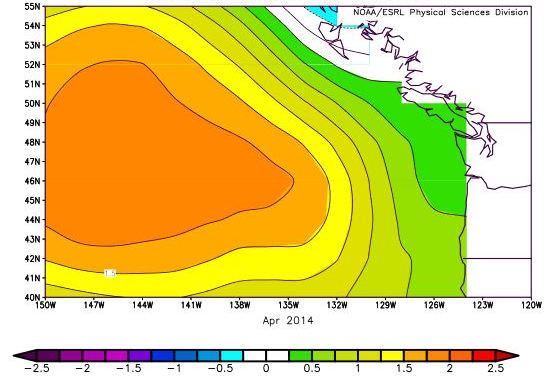
The Blob is a large mass of relatively warm water in the Pacific Ocean off the coast of North America that was first detected in late 2013 and continued to spread throughout 2014 and 2015. It is an example of a marine heatwave. Sea surface temperatures indicated that the Blob persisted into 2016, but it was initially thought to have dissipated later that year. By September 2016, the Blob resurfaced and made itself known to meteorologists. The warm water mass was unusual for open ocean conditions and was considered to have played a role in the formation of the unusual weather conditions experienced along the Pacific coast of North America during the same time period. The warm waters of the Blob were nutrient-poor and adversely affected marine life. In 2019 another scare was caused by a weaker form of the effect referred as "The Blob 2.0" and in 2021 the appearance of "The Southern Blob" at south of the equator near New Zealand has caused a major effect in South America, particula ... [...More Info...] [...Related Items...] OR: [Wikipedia] [Google] [Baidu] |
2011–2017 California Drought
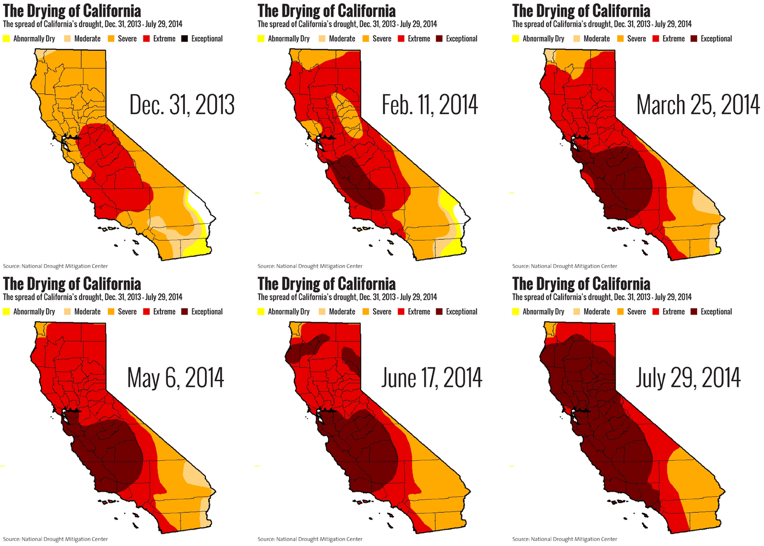
The 2011–2017 California drought persisted from December 2011 to March 2017 and consisted of the driest period in California's recorded history, late 2011 through 2014. The drought wiped out 102 million trees from 2011 to 2016, 62 million of those during 2016 alone. The cause of the drought was attributed to a ridge of high pressure in the Pacific Sea — the "Ridiculously Resilient Ridge" — which often barred powerful winter storms from reaching the state. By February 2017, the state's drought percentage returned to lower levels seen before the start of the drought. This change was due to an exceedingly wet pattern caused by atmospheric river-enhanced Pacific storms, which caused severe flooding. In mid-March 2019, California was declared drought-free except for a small pocket of "abnormally dry" conditions in Southern California. This declaration followed a series of powerful Pacific storms during the first few months of the year, which coincided with the U.S. experiencing ... [...More Info...] [...Related Items...] OR: [Wikipedia] [Google] [Baidu] |
NOAA
The National Oceanic and Atmospheric Administration (abbreviated as NOAA ) is an United States scientific and regulatory agency within the United States Department of Commerce that forecasts weather, monitors oceanic and atmospheric conditions, charts the seas, conducts deep sea exploration, and manages fishing and protection of marine mammals and endangered species in the U.S. exclusive economic zone. Purpose and function NOAA's specific roles include: * ''Supplying Environmental Information Products''. NOAA supplies to its customers and partners information pertaining to the state of the oceans and the atmosphere, such as weather warnings and forecasts via the National Weather Service. NOAA's information services extend as well to climate, ecosystems, and commerce. * ''Providing Environmental Stewardship Services''. NOAA is a steward of U.S. coastal and marine environments. In coordination with federal, state, local, tribal and international authorities, NOAA manages the ... [...More Info...] [...Related Items...] OR: [Wikipedia] [Google] [Baidu] |
Spring (season)
Spring, also known as springtime, is one of the four temperate seasons, succeeding winter and preceding summer. There are various technical definitions of spring, but local usage of the term varies according to local climate, cultures and customs. When it is spring in the Northern Hemisphere, it is autumn in the Southern Hemisphere and vice versa. At the spring (or vernal) equinox, days and nights are approximately twelve hours long, with daytime length increasing and nighttime length decreasing as the season progresses until the Summer Solstice in June (Northern Hemisphere) and December (Southern Hemisphere). Spring and "springtime" refer to the season, and also to ideas of rebirth, rejuvenation, renewal, resurrection and regrowth. Subtropical and tropical areas have climates better described in terms of other seasons, e.g. dry or wet, monsoonal or cyclonic. Cultures may have local names for seasons which have little equivalence to the terms originating in Europe. Meteoro ... [...More Info...] [...Related Items...] OR: [Wikipedia] [Google] [Baidu] |
Subtropic
The subtropical zones or subtropics are geographical and climate zones to the north and south of the tropics. Geographically part of the temperate zones of both hemispheres, they cover the middle latitudes from to approximately 35° north and south. The horse latitudes lie within this range. Subtropical climates are often characterized by hot summers and mild winters with infrequent frost. Most subtropical climates fall into two basic types: humid subtropical (Koppen climate Cfa), where rainfall is often concentrated in the warmest months, for example Southeast China and the Southeastern United States, and dry summer or Mediterranean climate (Koppen climate Csa/Csb), where seasonal rainfall is concentrated in the cooler months, such as the Mediterranean Basin or Southern California. Subtropical climates can also occur at high elevations within the tropics, such as in the southern end of the Mexican Plateau and in Da Lat of the Vietnamese Central Highlands. The six climate clas ... [...More Info...] [...Related Items...] OR: [Wikipedia] [Google] [Baidu] |


