|
Nome Census Area, Alaska
Nome Census Area is a census area located in the U.S. state of Alaska, mostly overlapping with the Seward Peninsula. As of the 2020 census, the population was 10,046, up from 9,492 in 2010. It is part of the unorganized borough and therefore has no borough seat. Its largest community by far is the city of Nome. Geography According to the U.S. Census Bureau, the census area has a total area of , of which is land and (18.8%) is water. It also includes the large offshore St. Lawrence Island, which has about 14 percent of the census area's population and two of its larger cities in Gambell and Savoonga. Nome Census Area is the 7th largest county-equivalent in the state of Alaska. Adjacent boroughs and census areas * Northwest Arctic Borough, Alaska - north * Yukon-Koyukuk Census Area, Alaska - east * Kusilvak Census Area, Alaska - south * Chukotsky District, Chukotka Autonomous Okrug - west National protected areas * Alaska Maritime National Wildlife Refuge (part of the B ... [...More Info...] [...Related Items...] OR: [Wikipedia] [Google] [Baidu] |
Iditarod Trail
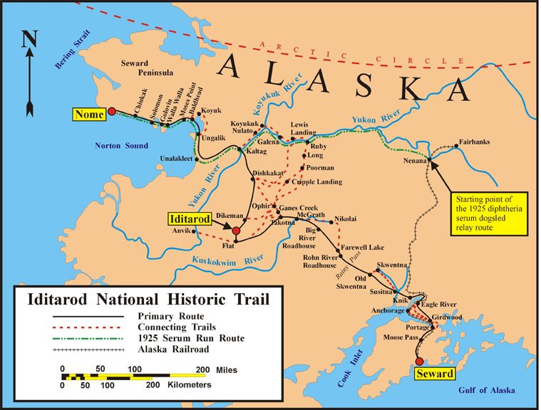
The Iditarod Trail, also known historically as the Seward-to-Nome Trail, is a thousand-plus mile (1,600 km) historic and contemporary trail system in the US state of Alaska. The trail began as a composite of trails established by Alaskan native peoples. Its route crossed several mountain ranges and valleys and passed through numerous historical settlements en route from Seward to Nome. The discovery of gold around Nome brought thousands of people over this route beginning in 1908. Roadhouses for people and dog barns sprang up every 20 or so miles. By 1918 World War I and the lack of 'gold fever' resulted in far less travel. The trail might have been forgotten except for the 1925 diphtheria outbreak in Nome. In one of the final great feats of dog sleds, twenty drivers and teams carried the life-saving serum in 127 hours. Today, the Iditarod Trail Sled Dog Race serves to commemorate the part the trail and its dog sleds played in the development of Alaska, and the route an ... [...More Info...] [...Related Items...] OR: [Wikipedia] [Google] [Baidu] |
Chukotsky District
Chukotsky District (russian: Чуко́тский райо́н, ''Čukótskiy rayón''; Chukchi: , ''Čukotkakèn rajon'') is an administrativeLaw #33-OZ and municipalLaw #47-OZ district (raion), one of the six in Chukotka Autonomous Okrug, Russia. It is the easternmost district of the autonomous okrug and Russia, and the closest part of Russia to the United States. It borders with the Chukchi Sea in the north, the Bering Sea in the east, Providensky District in the south, and the Kolyuchinskaya Bay in the west. The area of the district is .Official website of Chukotsky DistrictMap of the district Its administrative center is the rural locality (a '' selo'') of Lavrentiya. Population: The population of Lavrentiya accounts for 30.2% of the district's total population. The district is populated mainly by indigenous peoples, the majority being either Chukchi or Yupik. The sparse nature of the population means that this is the only district in the autonomous okrug without any urba ... [...More Info...] [...Related Items...] OR: [Wikipedia] [Google] [Baidu] |
Black People
Black is a racialized classification of people, usually a political and skin color-based category for specific populations with a mid to dark brown complexion. Not all people considered "black" have dark skin; in certain countries, often in socially based systems of racial classification in the Western world, the term "black" is used to describe persons who are perceived as dark-skinned compared to other populations. It is most commonly used for people of sub-Saharan African ancestry and the indigenous peoples of Oceania, though it has been applied in many contexts to other groups, and is no indicator of any close ancestral relationship whatsoever. Indigenous African societies do not use the term ''black'' as a racial identity outside of influences brought by Western cultures. The term "black" may or may not be capitalized. The '' AP Stylebook'' changed its guide to capitalize the "b" in ''black'' in 2020. The '' ASA Style Guide'' says that the "b" should not be capitalized. S ... [...More Info...] [...Related Items...] OR: [Wikipedia] [Google] [Baidu] |
White Americans
White Americans are Americans who identify as and are perceived to be white people. This group constitutes the majority of the people in the United States. As of the 2020 Census, 61.6%, or 204,277,273 people, were white alone. This represented a national white demographic decline from a 72.4% share of the US's population (white alone) in 2010. As of July 1, 2021, United States Census Bureau estimates that 75.8% of the US population were white alone, while Non-Hispanic whites were 59.3% of the population. White Hispanic and Latino Americans totaled about 12,579,626, or 3.8% of the population. European Americans are the largest panethnic group of white Americans and have constituted the majority population of the United States since the nation's founding. The US Census Bureau uses a particular definition of "white" that differs from some colloquial uses of the term. The Bureau defines "White" people to be those "having origins in any of the original peoples of Europe, the Midd ... [...More Info...] [...Related Items...] OR: [Wikipedia] [Google] [Baidu] |
Yupik Language
The Yupik languages () are a family of languages spoken by the Yupik peoples of western and south-central Alaska and Chukotka. The Yupik languages differ enough from one another that they are not mutually intelligible, although speakers of one of the languages may understand the general idea of a conversation of speakers of another of the languages. One of them, Sirenik, has been extinct since 1997. The Yupik languages are in the family of Eskimo–Aleut languages. The Aleut and Eskimo languages diverged around 2000 BC (contemporaneous with the split of Indo-Iranian); within the Eskimo classification, the Yupik languages diverged from each other and from the Inuit language around 1000 AD. List of languages # Naukan Yupik (also Naukanski): spoken by perhaps 100 people in and around Lavrentiya, Lorino, and Uelen on the Chukotka Peninsula of Eastern Siberia. # Central Siberian Yupik (also Yupigestun, Akuzipigestun, Akuzipik, Siberian Yupik, Siberian Yupik Eskimo, Centr ... [...More Info...] [...Related Items...] OR: [Wikipedia] [Google] [Baidu] |
Census
A census is the procedure of systematically acquiring, recording and calculating information about the members of a given population. This term is used mostly in connection with national population and housing censuses; other common censuses include censuses of agriculture, traditional culture, business, supplies, and traffic censuses. The United Nations (UN) defines the essential features of population and housing censuses as "individual enumeration, universality within a defined territory, simultaneity and defined periodicity", and recommends that population censuses be taken at least every ten years. UN recommendations also cover census topics to be collected, official definitions, classifications and other useful information to co-ordinate international practices. The UN's Food and Agriculture Organization (FAO), in turn, defines the census of agriculture as "a statistical operation for collecting, processing and disseminating data on the structure of agriculture, covering th ... [...More Info...] [...Related Items...] OR: [Wikipedia] [Google] [Baidu] |
Andreafsky Wilderness
Andreafsky Wilderness is a wilderness area in the U.S. state of Alaska. Located within the Yukon Delta National Wildlife Refuge, it is about in area, and was designated by the United States Congress in 1980. History Andreafsky Wilderness is designated by the United States Congress now it contains a total area of 1,300,000 acres and managed by Fish & Wildlife service. The Andreafsky River and its East Fork, in the northern section, flow southwest along parallel paths and drain into the Yukon River The Yukon River (Gwichʼin language, Gwich'in: ''Ųųg Han'' or ''Yuk Han'', Central Alaskan Yup'ik language, Yup'ik: ''Kuigpak'', Inupiaq language, Inupiaq: ''Kuukpak'', Deg Xinag language, Deg Xinag: ''Yeqin'', Hän language, Hän: ''Tth'echù' .... References External linksRecreation.gov - Andreafsky Wilderness Protected areas of Nome Census Area, Alaska Protected areas of Kusilvak Census Area, Alaska Wilderness areas of Alaska {{Alaska-protected-area-stub ... [...More Info...] [...Related Items...] OR: [Wikipedia] [Google] [Baidu] |
Yukon Delta National Wildlife Refuge
The Yukon Delta National Wildlife Refuge is a United States National Wildlife Refuge covering about in southwestern Alaska. It is the second-largest National Wildlife Refuge in the country, only slightly smaller than the Arctic National Wildlife Refuge. It is a coastal plain extending to the Bering Sea, covering the delta created by the Yukon and Kuskokwim rivers. The delta includes extensive wetlands near sea level that are often inundated by Bering Sea tides. It is bordered on the east by Wood-Tikchik State Park, the largest state park in the United States. The refuge is administered from offices in Bethel. U.S. President Theodore Roosevelt first set aside southwestern Alaska refuge lands in 1909. Other lands were added through the years until December 2, 1980, when President Jimmy Carter signed the Alaska National Interest Lands Conservation Act (ANILCA) into law, which created the Yukon Delta National Wildlife Reserve by consolidating existing refuges and adding additional land ... [...More Info...] [...Related Items...] OR: [Wikipedia] [Google] [Baidu] |
Bering Land Bridge National Preserve
The Bering Land Bridge National Preserve is one of the most remote Protected areas of the United States, located on the Seward Peninsula. The National Preserve protects a remnant of the Bering Land Bridge that connected Asia with North America more than 13,000 years ago during the Pleistocene ice age. The majority of this land bridge now lies beneath the waters of the Chukchi and Bering Seas. During the glacial epoch this bridge was a migration route for people, animals, and plants whenever ocean levels fell enough to expose the land bridge. Archeologists disagree whether it was across this Bering Land Bridge, also called Beringia, that humans first migrated from Asia to populate the Americas, or whether it was via a coastal route. Bering Land Bridge National Monument was established in 1978 by Presidential proclamation under the authority of the Antiquities Act. The designation was modified in 1980 to a national preserve with the passage of the Alaska National Interest Lands ... [...More Info...] [...Related Items...] OR: [Wikipedia] [Google] [Baidu] |
Sledge Island
Sledge Island, or Ayak Island, is a small island in the Bering Sea. It is located from the southwestern shore of the Seward Peninsula, off the shores of Alaska. Geography Sledge Island is of volcanic origin and is only across. The average elevation is . Administratively this island belongs to the Nome Census Area, Alaska. The island is long and wide. The island is part of the Bering Sea unit of the Alaska Maritime National Wildlife Refuge. History This island was named on August 5, 1778, by Captain James Cook, who commented: ''"We found, a little way from the shore where we landed, a sledge, which occasioned this name being given to the island."'' Martin Sauer, the secretary of the 1791 Russian expedition who sailed under orders from Catherine II of Russia, claimed in 1802 that the Inuit name of this island is "Ayak." Captain Frederick Beechey Frederick William Beechey (17 February 1796 – 29 November 1856) was an English naval officer, artist, explorer, hydrog ... [...More Info...] [...Related Items...] OR: [Wikipedia] [Google] [Baidu] |
King Island (Alaska)
King Island ( ik, Ugiuvak; russian: Остров Кинг) (King's Island in early US sources) is an island in the Bering Sea, west of Alaska. It is about west of Cape Douglas and is south of Wales, Alaska. Geography King island is a small island located about offshore, south of the village of Wales, Alaska and about 90 miles northwest of Nome. The island is about wide with steep slopes on all sides. It was named by James Cook, first European to sight the island in 1778, for Lt. James King, a member of his party. It is part of the Bering Sea unit of the Alaska Maritime National Wildlife Refuge. Population The island was once the winter home of a group of about 413 Inupiat who called themselves Asiuluk, meaning "people of the sea," or Ugiuvaŋmiut, from Ugiuvak, the village of King Island and "miut," meaning "people of" or "group of people". The Ugiuvaŋmiut spent their summers engaging in subsistence hunting and gathering on King Island and on the mainland near the location o ... [...More Info...] [...Related Items...] OR: [Wikipedia] [Google] [Baidu] |


