|
Nibok District
Nibok is a district in the island nation of Nauru in the Micronesian South Pacific. It is located in the west of the island and covers an area of 1.6 square kilometres (395 acres). Nibok is a part of the Ubenide Constituency. As of 2011, the population was 484. The NPC field workshops are located in Nibok. Education Nibok Infant School is in Nibok.Education Statistics Digest 2015 " . Retrieved on July 8, 2018. p. 47 (PDF p. 47). The primary and secondary schools serving all of Nauru are Yaren Primary School in |
Districts Of Nauru
Nauru ( or ; na, Naoero), officially the Republic of Nauru ( na, Repubrikin Naoero) and formerly known as Pleasant Island, is an island country and microstate in Oceania, in the Central Pacific. Its nearest neighbour is Banaba Island in Kiribati, about to the east. It further lies northwest of Tuvalu, northeast of Solomon Islands, east-northeast of Papua New Guinea, southeast of the Federated States of Micronesia and south of the Marshall Islands. With only a area, Nauru is the third-smallest country in the world behind Vatican City and Monaco, making it the smallest republic as well as the smallest island nation. Its population of about 10,000 is the world's second-smallest (not including colonies or overseas territories), after Vatican City. Settled by people from Micronesia circa 1000 BCE, Nauru was annexed and claimed as a colony by the German Empire in the late 19th century. After World War I, Nauru became a League of Nations mandate administered by Aust ... [...More Info...] [...Related Items...] OR: [Wikipedia] [Google] [Baidu] |
Nauru Phosphate Corporation
The Nauru Phosphate Corporation (NPC) was a government-owned company controlling phosphate mining in Nauru, now known as the Republic of Nauru Phosphate, or RONPhos. Failed investments In the early years of the Nauru Phosphate Royalties Development Trust, it financed the construction of two of five high-rise luxury condos in Hawaii (on the island of Oahu). The five towers (two completed as of October 2005) are on prime Honolulu real estate with ocean views and represent a benchmark in Honolulu luxury high-rises. Other investments included Nauru House in Melbourne and Hawaiki Tower in Honolulu. These luxury properties were only part of an international real estate portfolio that stretched into countries including Australia, the Philippines, Fiji, Guam, Samoa, the US, New Zealand, and the United Kingdom. Financial mismanagement and extravagant government spending (i.e., investing A$4 million in a London play, '' Leonardo the Musical: A Portrait of Love'', about Leonardo da Vinc ... [...More Info...] [...Related Items...] OR: [Wikipedia] [Google] [Baidu] |
List Of Settlements In Nauru ...
The Republic of Nauru originally consisted of 169 villages; by 1900 these were already partly abandoned, uninhabited or destroyed. With the increasing population growth the single villages merged into a single connected settlement, which today is spread out around the entire coastal strip. The village names are from the book Nauru - Ergebnisse der Südseeexpedition by Paul Hambruch, who researched on the island during the Hamburger Südsee-Expedition 1908–1910. The village names were changed following the orthographic reform of the Nauruan language of 1939. List See also * Geography of Nauru {{Nauru topics Nauru Cities A city is a human settlement of notable size.Goodall, B. (1987) ''The Penguin Dictionary of Human Geography''. London: Penguin.Kuper, A. and Kuper, J., eds (1996) ''The Social Science Encyclopedia''. 2nd edition. London: Routledge. It can be def ... [...More Info...] [...Related Items...] OR: [Wikipedia] [Google] [Baidu] |
Geography Of Nauru
Nauru is a tiny phosphate rock island nation located in the South Pacific Ocean south of the Marshall Islands in Oceania. It is only south of the Equator at coordinates . Nauru is one of the three great phosphate rock islands in the Pacific Ocean—the others are Banaba (Ocean Island) in Kiribati and Makatea in French Polynesia. Its land area is , and it has a . Maritime claims are an Exclusive Economic Zone of with 200-nautical-miles (370 km), and a 12-nautical-mile (22 km) territorial sea. The climate is tropical with a monsoon rainy season from November to February. A sandy beach rises to the fertile ring around raised coral reefs. The raised phosphate plateau ('Topside') takes up the central portion of the island. The highest point is 213 ft (65 m) above sea level, along the plateau rim. Nauru's only economically significant natural resources are phosphates, formed from guano deposits by seabirds, and fisheries, particularly for tuna. Due to being s ... [...More Info...] [...Related Items...] OR: [Wikipedia] [Google] [Baidu] |
OHCHR
The Office of the United Nations High Commissioner for Human Rights, commonly known as the Office of the High Commissioner for Human Rights (OHCHR) or the United Nations Human Rights Office, is a department of the Secretariat of the United Nations that works to promote and protect human rights that are guaranteed under international law and stipulated in the Universal Declaration of Human Rights of 1948. The office was established by the United Nations General Assembly on 20 December 1993 in the wake of the 1993 World Conference on Human Rights. The office is headed by the High Commissioner for Human Rights, who co-ordinates human rights activities throughout the United Nations System and acts as the secretariat of the Human Rights Council in Geneva, Switzerland. The eighth and current High Commissioner is Volker Türk of Austria, who succeeded Michelle Bachelet of Chile on 8 September 2022. In 2018–2019, the department had a budget of $201.6 million (3.7 per cent of the reg ... [...More Info...] [...Related Items...] OR: [Wikipedia] [Google] [Baidu] |
Nauru Secondary School
Nauru Secondary School (abbreviated as NSS) is an upper Government school, public secondary school in the Yaren District, Nauru, located in the Nauru Learning Village, along with the University of the South Pacific Nauru Campus and the Nauru Technical & Vocational Education Training Centre. The school served years 10-12 and had the final stages of secondary education in Nauru. it served years 8 through 12. It uses the curriculum of Queensland, Australia.Teachers for Nauru " Queensland Government. Retrieved on July 5, 2018. In the 1950s it served grades 4 and 5, and a new building opened in 1954. Reuben Kun, who wrote an article about Nauru's university system, stated that in that period there was an unanticipated increase in the number of students at the school. The school had classes teaching Nauruan langua ... [...More Info...] [...Related Items...] OR: [Wikipedia] [Google] [Baidu] |
Meneng District
Meneng (or Menen) is a district located in the Meneng Constituency in the country of Nauru. The constituency elects 2 members to the Parliament of Nauru in Yaren District, Yaren. Geography The district is located in the southeast of the island, covering an area of 3.1 km². It has a population of 1,400. Meneng District has 18 villages, the most of any district in Nauru. Local features Features in Meneng include: * The Menen Hotel, one of the island's four hotels * the wireless station * the State House (presidential residence; recently burned down) * the Government Printing Office * the Meneng Stadium * Australian Nauru Detention Centre Education Meneng Infant School is in Meneng.Education Statistics Digest 2015 " Department of Education (Nauru). Retrieved on July 8, 2018. p. 47 ... [...More Info...] [...Related Items...] OR: [Wikipedia] [Google] [Baidu] |
Yaren District
Yaren (in earlier times Makwa/Moqua) is a district of the Pacific nation of Nauru. It is the ''de facto'' capital of Nauru and is coextensive with Yaren Constituency.Constituencies of Nauru (naurugov.nr) History The district was created in 1968. Its original name, Makwa (or Moqua), refers to Moqua Well, an and primary source of drinking water for Nauruan people."Moqua Caves and Moqua Well"Gatis Pāvils, 30 October 2011. G ...
|
Department Of Education (Nauru)
An education ministry is a national or subnational government agency politically responsible for education. Various other names are commonly used to identify such agencies, such as Ministry of Education, Department of Education, and Ministry of Public Education, and the head of such an agency may be a minister of education or secretary of education. Such agencies typically address educational concerns such as the quality of schools or standardization of curriculum. The first such ministry ever is considered to be the Commission of National Education ( pl, Komisja Edukacji Narodowej, lt, Edukacinė komisija), founded in 1773 in the Polish–Lithuanian Commonwealth. Following is a list of education ministries by country: Africa * Ministry of National Education (Algeria) * Ministry of Education (Egypt) * Ministry of Education (Ethiopia) * Ministry of Education (Ghana) * Ministry of Education (Kenya) * Ministry of Education (Namibia) * Nigeria: :* Federal Ministry of Education ( ... [...More Info...] [...Related Items...] OR: [Wikipedia] [Google] [Baidu] |
Acres
The acre is a unit of land area used in the imperial and US customary systems. It is traditionally defined as the area of one chain by one furlong (66 by 660 feet), which is exactly equal to 10 square chains, of a square mile, 4,840 square yards, or 43,560 square feet, and approximately 4,047 m2, or about 40% of a hectare. Based upon the international yard and pound agreement of 1959, an acre may be declared as exactly 4,046.8564224 square metres. The acre is sometimes abbreviated ac but is usually spelled out as the word "acre".National Institute of Standards and Technolog(n.d.) General Tables of Units of Measurement . Traditionally, in the Middle Ages, an acre was conceived of as the area of land that could be ploughed by one man using a team of 8 oxen in one day. The acre is still a statutory measure in the United States. Both the international acre and the US survey acre are in use, but they differ by only four parts per million (see below). The most common use of ... [...More Info...] [...Related Items...] OR: [Wikipedia] [Google] [Baidu] |
Denigomodu District
Denigomodu is a district in the western part of the island of Nauru. It is the most populous district in Nauru. It houses the expatriate housing compound "The Location". This makes it Nauru's largest settlement by population. 25.7% of the people in Nauru live in Denigomodu. Geography The district, part of the constituency of Ubenide, covers an area of 1.18 km², and has a population of 2,827, making it the most populous of the fourteen Nauruan districts. Local features In this district is the laborers' settlement for the phosphate mining workers of the Nauru Phosphate Corporation (NPC). Also located in Denigomodu are: * Republic of Nauru Hospital * NPC planning and construction offices * Eigigu Supermarket Education The primary and secondary schools serving all of Nauru are Yaren Primary School in Yaren District (years 1-3), Nauru Primary School in Meneng District (years 4-6), Nauru College in Denigomodu District (years 7-9), and Nauru Secondary School (years 10-12) in Ya ... [...More Info...] [...Related Items...] OR: [Wikipedia] [Google] [Baidu] |
Australasia
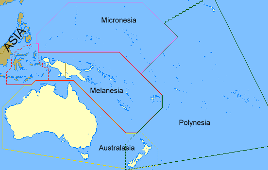
Australasia is a region that comprises Australia, New Zealand and some neighbouring islands in the Pacific Ocean. The term is used in a number of different contexts, including geopolitically, physiogeographically, philologically, and ecologically, where the term covers several slightly different, but related regions. Derivation and definitions Charles de Brosses coined the term (as French ''Australasie'') in ''Histoire des navigations aux terres australes'' (1756). He derived it from the Latin for "south of Asia" and differentiated the area from Polynesia (to the east) and the southeast Pacific (Magellanica). In the late 19th century, the term Australasia was used in reference to the "Australasian colonies". In this sense it related specifically to the British colonies south of Asia: New South Wales, Queensland, South Australia, Tasmania, Western Australia, Victoria (i.e., the Australian colonies) and New Zealand. Australasia found continued geopolitical attention in the earl ... [...More Info...] [...Related Items...] OR: [Wikipedia] [Google] [Baidu] |


