|
Needham Center (MBTA Station)
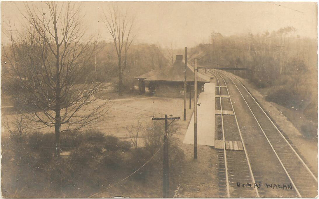
Needham Center station is a commuter rail station on the MBTA Commuter Rail Needham Line, located just north of Great Plain Avenue ( MA-135) in downtown Needham, Massachusetts. The first station at Needham opened in 1853; it burned in 1887 and was replaced with a stone station, some of which is still in place. The has a single side platform with an accessible mini-high platform serving the line's single track. History Great Plain On June 1, 1853, the Charles River Branch Railroad was extended from Newton Upper Falls into Needham as the first stage of a line to Dover and beyond. The railroad was not able to follow its original plan to go through the East Village, Needham's historical center, because one landowner refused to sell; instead, it was routed to Great Plain station in Great Plain Village further to the east. Great Plain served as the terminus of the railroad until it was extended to Medway in 1861 and to Woonsocket in 1863. Needham With the coming of the railroad ... [...More Info...] [...Related Items...] OR: [Wikipedia] [Google] [Baidu] |
Needham, Massachusetts
Needham ( ) is a town in Norfolk County, Massachusetts. A suburb of Boston, its population was 32,091 at the 2020 U.S. Census. It is home of Olin College. History Early settlement Needham was first settled in 1680 with the purchase of a tract of land measuring by from Chief Nehoiden for the sum of 10 pounds, of land, and 40 shillings worth of corn. It was officially incorporated in 1711. Originally part of the Dedham Grant, Needham split from Dedham and was named after the town of Needham Market in Suffolk, England. Just 15 months after asking for their own church, 40 men living on the north side of the Charles River suddenly asked the General Court to separate them from Dedham. Their petition cited the inadequate services provided, namely schools and churches. They also said that, if they were simply to be made a precinct instead of a separate town, that they would suffer political reprisals. Dedham agreed that the services were inadequate and did not oppose the ... [...More Info...] [...Related Items...] OR: [Wikipedia] [Google] [Baidu] |
New York And New England Railroad
The New York and New England Railroad (NY&NE) was a railroad connecting southern New York State with Hartford, Connecticut; Providence, Rhode Island; and Boston, Massachusetts. It operated under that name from 1873 to 1893. Prior to 1873 it was known as the Boston, Hartford and Erie Railroad, which had been formed from several smaller railroads that dated back to 1846. After a bankruptcy in 1893, the NY&NE was reorganized and briefly operated as the New England Railroad before being leased to the competing New York, New Haven and Hartford Railroad in 1898. Today, most of the original New York and New England lines have been abandoned. A segment in Massachusetts is now part of the MBTA's Franklin Line providing commuter rail service to South Station in Boston, and another segment near East Hartford and Manchester, Connecticut, is used for freight service on the Connecticut Southern Railroad. Other portions in Connecticut and Rhode Island have been converted to rail trails. Hist ... [...More Info...] [...Related Items...] OR: [Wikipedia] [Google] [Baidu] |
MBTA Commuter Rail Stations In Norfolk County, Massachusetts
The Massachusetts Bay Transportation Authority (abbreviated MBTA and known colloquially as "the T") is the public agency responsible for operating most public transportation services in Greater Boston, Massachusetts. The MBTA transit network includes the MBTA subway with three metro lines (the Blue, Orange, and Red lines), two light rail lines (the Green and Ashmont–Mattapan lines), and a five-line bus rapid transit system (the Silver Line); MBTA bus local and express service; the twelve-line MBTA Commuter Rail system, and several ferry routes. In , the system had a ridership of , or about per weekday as of , of which the rapid transit lines averaged and the light rail lines , making it the fourth-busiest rapid transit system and the third-busiest light rail system in the United States. As of , average weekday ridership of the commuter rail system was , making it the sixth-busiest commuter rail system in the U.S. The MBTA is the successor of several previous public ... [...More Info...] [...Related Items...] OR: [Wikipedia] [Google] [Baidu] |
Stations Along New York, New Haven And Hartford Railroad Lines
Station may refer to: Agriculture * Station (Australian agriculture), a large Australian landholding used for livestock production * Station (New Zealand agriculture), a large New Zealand farm used for grazing by sheep and cattle ** Cattle station, a cattle-rearing station in Australia or New Zealand **Sheep station, a sheep-rearing station in Australia or New Zealand Communications * Radio communication station, a radio frequency communication station of any kind, including audio, TV, and non-broadcast uses ** Radio broadcasting station, an audio station intended for reception by the general public ** Amateur radio station, a station operating on frequencies allocated for ham or other non-commercial use ** Broadcast relay station ** Ground station (or Earth station), a terrestrial radio station for extraplanetary telecommunication with satellites or spacecraft ** Television station * Courier station, a relay station in a courier system ** Station of the ''cursus publicus'', a sta ... [...More Info...] [...Related Items...] OR: [Wikipedia] [Google] [Baidu] |
Buildings And Structures In Needham, Massachusetts
A building, or edifice, is an enclosed structure with a roof and walls standing more or less permanently in one place, such as a house or factory (although there's also portable buildings). Buildings come in a variety of sizes, shapes, and functions, and have been adapted throughout history for a wide number of factors, from building materials available, to weather conditions, land prices, ground conditions, specific uses, prestige, and aesthetic reasons. To better understand the term ''building'' compare the list of nonbuilding structures. Buildings serve several societal needs – primarily as shelter from weather, security, living space, privacy, to store belongings, and to comfortably live and work. A building as a shelter represents a physical division of the human habitat (a place of comfort and safety) and the ''outside'' (a place that at times may be harsh and harmful). Ever since the first cave paintings, buildings have also become objects or canvasses of much artistic ... [...More Info...] [...Related Items...] OR: [Wikipedia] [Google] [Baidu] |
Accessible
Accessibility is the design of products, devices, services, vehicles, or environments so as to be usable by people with disabilities. The concept of accessible design and practice of accessible development ensures both "direct access" (i.e. unassisted) and "indirect access" meaning compatibility with a person's assistive technology (for example, computer screen readers). Accessibility can be viewed as the "ability to access" and benefit from some system or entity. The concept focuses on enabling access for people with disabilities, or enabling access through the use of assistive technology; however, research and development in accessibility brings benefits to everyone. Accessibility is not to be confused with usability, which is the extent to which a product (such as a device, service, or environment) can be used by specified users to achieve specified goals with effectiveness, efficiency, convenience, or satisfaction in a specified context of use. Accessibility is also s ... [...More Info...] [...Related Items...] OR: [Wikipedia] [Google] [Baidu] |
Southwest Corridor (Boston)
The Southwest Corridor or Southwest Expressway was a project designed to bring an eight-lane highway into the City of Boston from a direction southwesterly of downtown. It was supposed to connect with Interstate 95 (I-95) at Route 128. As originally designed, it would have followed the right of way of the former Penn Central/New Haven Railroad mainline (current Amtrak Northeast Corridor) running from Readville, north through Roslindale, Forest Hills and Jamaica Plain, where it would have met the also-cancelled I-695 (Inner Belt Expressway). The 50-foot-wide (15 m) median for the uncompleted "Southwest Expressway" would have carried the southwest stretch of the MBTA Orange Line within it, replacing the Washington Street Elevated railway's 1901/1909-built elevated railbed. Another highway, the four-lane South End Bypass, was proposed to run along the railroad corridor between I-695 in Roxbury and I-90 near Back Bay. History Early railroad history The Boston and Providence Railroa ... [...More Info...] [...Related Items...] OR: [Wikipedia] [Google] [Baidu] |
Penn Central
The Penn Central Transportation Company, commonly abbreviated to Penn Central, was an American Railroad classes, class I railroad that operated from 1968 to 1976. Penn Central combined three traditional corporate rivals (the Pennsylvania Railroad, Pennsylvania, New York Central Railroad, New York Central and the New York, New Haven and Hartford Railroad, New York, New Haven and Hartford railroads), all united by heavy service into the New York metropolitan area and (to a lesser extent) New England and Chicago. The new company failed barely two years after formation, the largest bankruptcy in U.S. history at the time. The Penn Central's railroad assets were nationalized into Conrail along with the other bankrupt northeastern roads; its real estate and insurance holdings successfully Reorganization, reorganized into American Premier Underwriters. History Pre-merger The Penn Central railroad system developed in response to challenges facing Northeast United States, northeaste ... [...More Info...] [...Related Items...] OR: [Wikipedia] [Google] [Baidu] |
MBTA
The Massachusetts Bay Transportation Authority (abbreviated MBTA and known colloquially as "the T") is the public agency responsible for operating most public transportation services in Greater Boston, Massachusetts. The MBTA transit network includes the MBTA subway with three metro lines (the Blue, Orange, and Red lines), two light rail lines (the Green and Ashmont–Mattapan lines), and a five-line bus rapid transit system (the Silver Line); MBTA bus local and express service; the twelve-line MBTA Commuter Rail system, and several ferry routes. In , the system had a ridership of , or about per weekday as of , of which the rapid transit lines averaged and the light rail lines , making it the fourth-busiest rapid transit system and the third-busiest light rail system in the United States. As of , average weekday ridership of the commuter rail system was , making it the sixth-busiest commuter rail system in the U.S. The MBTA is the successor of several previous public a ... [...More Info...] [...Related Items...] OR: [Wikipedia] [Google] [Baidu] |
Highland Branch
The Highland branch, also known as the Newton Highlands branch, was a suburban railway line in Boston, Massachusetts. It was opened by the Boston and Albany Railroad in 1886 to serve the growing community of Newton, Massachusetts. The line was closed in 1958 and sold to the Metropolitan Transit Authority (MTA), the predecessor of the current Massachusetts Bay Transportation Authority (MBTA), which reopened it in 1959 as a light rail line, now known as the D branch of the Green Line. The first section of what became the Highland branch was built by the Boston and Worcester Railroad between Boston and Brookline in 1848. The Charles River Branch Railroad, a forerunner of the New York and New England Railroad, extended the line to Newton Upper Falls in 1852. The B&A bought the line in 1883 and extended to Riverside, rejoining its main line there. The MTA electrified the line when it rebuilt it for light rail use. The conversion of the Highland branch into a light rail line was p ... [...More Info...] [...Related Items...] OR: [Wikipedia] [Google] [Baidu] |
Boston And Albany Railroad
The Boston and Albany Railroad was a railroad connecting Boston, Massachusetts to Albany, New York, later becoming part of the New York Central Railroad system, Conrail, and CSX Transportation. The line is currently used by CSX for freight. Passenger service is provided on the line by Amtrak, as part of their ''Lake Shore Limited'' service, and by the MBTA Commuter Rail system, which owns the section east of Worcester and operates it as its Framingham/Worcester Line. History When the Erie Canal opened in 1825, New York City's advantageous water connection through the Hudson River threatened Boston's historical dominance as a trade center. Since the Berkshires made construction of a canal infeasible, Boston turned to the emerging railroad technology for a share of the freight to and from the Midwestern United States. The Boston and Worcester Railroad was chartered June 23, 1831 and construction began in August 1832. The line opened in sections: to West Newton on April 16, 18 ... [...More Info...] [...Related Items...] OR: [Wikipedia] [Google] [Baidu] |
Needham Cutoff
The Needham Line is a branch of the MBTA Commuter Rail system, running west from downtown Boston, Massachusetts through Roxbury, Jamaica Plain, Roslindale, West Roxbury, and the town of Needham. The second-shortest line of the system at just 13.7 miles long, it carried 4,881 daily riders in October 2022. Unlike the MBTA's eleven other commuter rail lines, the Needham Line is not a former intercity mainline; instead, it is composed of a former branch line, a short segment of one intercity line (running in the reverse of its original direction), and a 1906-built connector. History Dedham branch The Boston and Providence Railroad (B&P) opened its main line from Boston through Toll Gate (Forest Hills) to Providence in 1834. A branch line from Forest Hills to Dedham via West Roxbury was opened on June 3, 1850 by the B&P. South Street (Roslindale), Central (Bellevue), and West Roxbury all opened with the branch; Highland was added around 1855. Charles River Branch Railroad On ... [...More Info...] [...Related Items...] OR: [Wikipedia] [Google] [Baidu] |


