|
Ngalda River
Ngalda River is a river in Nigeria that has its source in the commercial town of Ngalda community, in Fika local government area of Yobe State. The Ngalda is also connected with Ngaji River Ngaji River is a river in the northern part of Nigeria. Originating in the wetland areas of Gadaka town in Yobe State, it runs some 40 kilometres south to Ngalda and where it joins with the Ngalda River about 22.2 kilometres south of Fika town. ... about 40 kilometres to the north. The 2022 flooding from the river has made over 1000 people homeless. References Rivers of Nigeria {{Nigeria-river-stub ... [...More Info...] [...Related Items...] OR: [Wikipedia] [Google] [Baidu] |
Nigeria
Nigeria ( ), , ig, Naìjíríyà, yo, Nàìjíríà, pcm, Naijá , ff, Naajeeriya, kcg, Naijeriya officially the Federal Republic of Nigeria, is a country in West Africa. It is situated between the Sahel to the north and the Gulf of Guinea to the south in the Atlantic Ocean. It covers an area of , and with a population of over 225 million, it is the most populous country in Africa, and the world's sixth-most populous country. Nigeria borders Niger in the north, Chad in the northeast, Cameroon in the east, and Benin in the west. Nigeria is a federal republic comprising of 36 states and the Federal Capital Territory, where the capital, Abuja, is located. The largest city in Nigeria is Lagos, one of the largest metropolitan areas in the world and the second-largest in Africa. Nigeria has been home to several indigenous pre-colonial states and kingdoms since the second millennium BC, with the Nok civilization in the 15th century BC, marking the first ... [...More Info...] [...Related Items...] OR: [Wikipedia] [Google] [Baidu] |
Fika, Nigeria
Fika is a Local Government Area in Yobe State, Nigeria. Its headquarters are in the town of Fika in the south of the area at. It has an area of 2,852 km and a population of 215,000 at the 2022 census. The postal code of the area is 622. Geography The northeasterly line of equal latitude and longitude passes through the area close to Fika. Gadaka is Also the largest town in the Fika LGA. It is located at about 12 km off the Potiskum-Gombe main road, about 55 km from the commercial city of Potiskum. List of Districts under Fika Daya Fika Gadaka Shembire Gudi Dozi Godo wali Maluri Janga Boza Zangaya Mazawaun Mubi Fusami Garin wayo T.nanai Fa.sawa See also * List of Local Government Areas in Yobe State Yobe was created on 27 August 1991. It is a mainly agricultural state, and it is a state located in northeastern Nigeria. Yobe State was carved out of Borno State. The capital of Yobe State is Damaturu; its largest and most populated city is ... [...More Info...] [...Related Items...] OR: [Wikipedia] [Google] [Baidu] |
Yobe State
Yobe is a state located in northeastern Nigeria. A mainly agricultural state, it was created on 27 August 1991. Yobe State was carved out of Borno State. The capital of Yobe State is Damaturu; and it's largest and most populated city is Potiskum. Geography The state borders four states: Bauchi, Borno, Gombe, and Jigawa.Yobe State shares borders with Borno State to the east, Gombe State to the south, Bauchi and Jigawa States to the west and Niger Republic to the north. It borders to the north the Diffa and Zinder Regions of Niger. Because the state lies mainly in the dry savanna belt, conditions are hot and dry for most of the year, except in the southern part of the state which has more annual rainfall. History Yobe State came into being on 27 August 1991. It was carved out of the old Borno State by the Babangida administration. Yobe State was created because the old Borno State was one of Nigeria's largest states in terms of land area and was therefore considered to be ... [...More Info...] [...Related Items...] OR: [Wikipedia] [Google] [Baidu] |
Ngaji River
Ngaji River is a river in the northern part of Nigeria. Originating in the wetland areas of Gadaka town in Yobe State, it runs some 40 kilometres south to Ngalda and where it joins with the Ngalda River about 22.2 kilometres south of Fika town. See also * Yobe River The Yobe River, also known as the Komadougou Yobe or the Komadougou-Yobe (french: Komadougou Yobé), is a river in West Africa that flows into Lake Chad through Nigeria and Niger. Its tributaries include the Hadejia River, the Jama'are River ... References Rivers of Nigeria {{Nigeria-river-stub ... [...More Info...] [...Related Items...] OR: [Wikipedia] [Google] [Baidu] |
Northern Nigeria
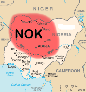
Northern Nigeria was an autonomous division within Nigeria, distinctly different from the southern part of the country, with independent customs, foreign relations and security structures. In 1962 it acquired the territory of the United Kingdom, British Northern Cameroons, which voted to become a province within Northern Nigeria. In 1967, Northern Nigeria was divided into the North-Eastern State, North-Western State, Kano State, Kaduna State, Kwara State, and the Benue-Plateau State, each with its own Governor. History Prehistory The Nok culture, an ancient culture dominated most of what is now Culture of Northern Nigeria, Northern Nigeria in prehistoric times, its legacy in the form of terracotta statues and megaliths have been discovered in Sokoto State, Sokoto, Kano (city), Kano, Birnin Kebbi, Birinin Kudu, Nok and Zaria. The Kwatarkwashi Culture, Kwatarkwashi culture, a variant of the Nok culture centred mostly around Zamfara State, Zamfara in Sokoto Province is thoug ... [...More Info...] [...Related Items...] OR: [Wikipedia] [Google] [Baidu] |

