|
New York State Route 78A
New York State Route 78 (NY 78) is a state highway in western New York in the United States. While it is signed north–south, the southern portion runs in an east–west direction across Wyoming County, New York, Wyoming and Erie County, New York, Erie counties, from its beginning at a junction with New York State Route 19, NY 19 north of the village of Gainesville (village), New York, Gainesville to the village of East Aurora, New York, East Aurora. The part of the route north of East Aurora follows a generally north–south alignment to an intersection with New York State Route 18, NY 18 in the Niagara County, New York, Niagara County town of Newfane, New York, Newfane (at the hamlet of Olcott, New York, Olcott), just south of the Lake Ontario shoreline. The route is most closely identified in the region with Transit Road, a major north–south trunk road through the center of Erie and Niagara counties; however, NY 78 does not follow Transit Road for i ... [...More Info...] [...Related Items...] OR: [Wikipedia] [Google] [Baidu] |
New York State Department Of Transportation
The New York State Department of Transportation (NYSDOT) is the department of the New York state government responsible for the development and operation of highways, railroads, mass transit systems, ports, waterways and aviation facilities in the U.S. state of New York. This transportation network includes: * A state and local highway system, encompassing over 110,000 miles (177,000 km) of highway and 17,000 bridges. * A 5,000 mile (8,000 km) rail network, carrying over 42 million short tons (38 million metric tons) of equipment, raw materials, manufactured goods and produce each year. * Over 130 public transit operators, serving over 5.2 million passengers each day. * Twelve major public and private ports, handling more than 110 million short tons (100 million metric tons) of freight annually. * 456 public and private aviation facilities, through which more than 31 million people travel each year. It owns two airports, Stewart International Airport near Newburgh, ... [...More Info...] [...Related Items...] OR: [Wikipedia] [Google] [Baidu] |
Newfane, New York
Newfane is a town in Niagara County, New York, United States. The population was 9,666 at the 2010 census. The name was suggested by an early settler. The Town of Newfane is in the north-central part of the county, north of the City of Lockport. History The Town of Newfane was established in 1824 by Wesley R. Rupert and others it is made up of parts of the Towns of Hartland, Somerset, and Wilson. The first town meeting was held at the Van Horn Mansion in 1824. At one time, the community was known as "Charlotte" and "Charlottesville," but then was renamed Newfane ("New Fane" = "New Church"). Its school district includes an Early Childhood Center, Elementary school, Middle School, and one High School. The school's mascot is a panther. In Olcott, there is a monument with a handful of names of soldiers who fought for the Union cause in the American Civil War. In total, 252 Union soldiers came from Newfane, of which about 55 died during service. Olcott is also home to an o ... [...More Info...] [...Related Items...] OR: [Wikipedia] [Google] [Baidu] |
County Route 11 (Wyoming County, New York)
New York State Route 98 (NY 98) is a state highway in the western part of New York in the United States. The southern terminus of the route is at an intersection with U.S. Route 219 (US 219) in the town of Great Valley in Cattaraugus County. The northern end is at an interchange with the Lake Ontario State Parkway in the town of Carlton in Orleans County, near the southern shore of Lake Ontario. In between, NY 98 serves the city of Batavia, connects to the New York State Thruway ( Interstate 90 or I-90), and passes by the Attica Correctional Facility. Most of the route passes through rural, undeveloped areas; however, in southern Genesee County, it traverses more urbanized areas that lie in and around Batavia. Most of modern NY 98 north of Batavia was originally designated as New York State Route 74 in the mid-1920s. It was extended south to US 20 (now US 20A) in Varysburg in the late 1920s. NY 98, meanwhile, was ... [...More Info...] [...Related Items...] OR: [Wikipedia] [Google] [Baidu] |
County Route 54 (Wyoming County, New York)
County routes in Wyoming County, New York, serve as connections between major routes in the county. Wyoming County does not use the Manual on Uniform Traffic Control Devices-standard yellow-on-blue pentagonal route marker to sign its county routes; however, most county route numbers are listed on street blade signs. Routes 1–30 Routes 31 and up See also *County routes in New York *List of former state routes in New York (301–400) Notes References {{reflist, refs= {{cite web, url=https://www.dot.ny.gov/divisions/engineering/technical-services/hds-respository/NYSDOT_2021_LHI_County_Roads_Wyoming_County.pdf, title=County Roads Listing - Wyoming County, publisher=New York State Department of Transportation The New York State Department of Transportation (NYSDOT) is the department of the New York state government responsible for the development and operation of highways, railroads, mass transit systems, ports, waterways and aviation facilities in ..., access-date=August ... [...More Info...] [...Related Items...] OR: [Wikipedia] [Google] [Baidu] |
New York State Route 362
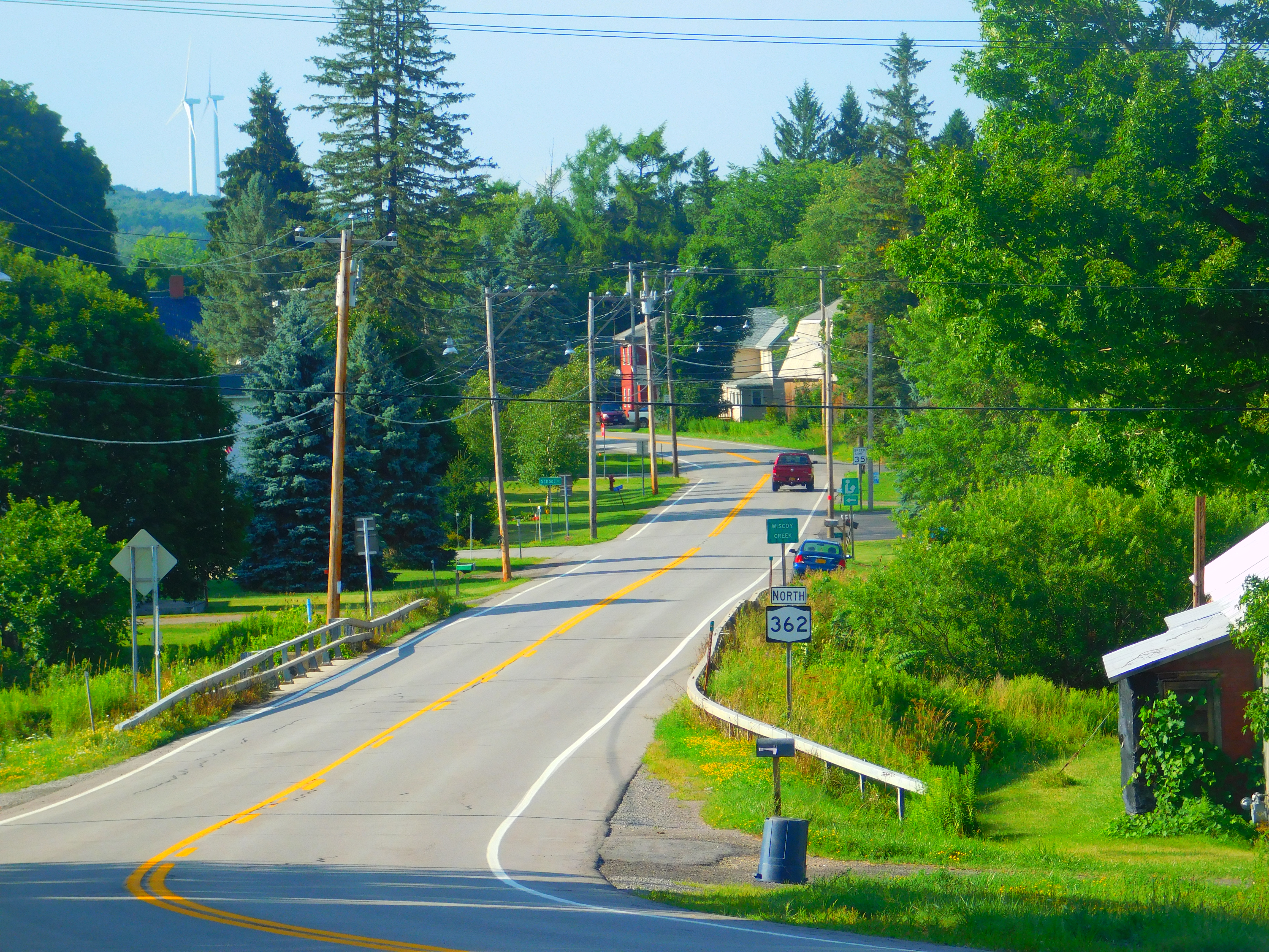
New York State Route 362 (NY 362) is a state highway located entirely in Wyoming County, New York, in the United States. It runs north–south for between an intersection with NY 39 in the town of Eagle and a junction with NY 78 in the town of Wethersfield. The two-lane route begins in the hamlet of Bliss, and heads across gradually less developed areas as it heads north from the community. NY 362 was assigned to its current routing as part of the 1930 renumbering of state highways in New York. Route description NY 362 begins at an intersection with NY 39 in the hamlet of Bliss, located within the town of Eagle. The route heads north through the community as a two-lane road, traversing several residential blocks ahead of a junction with Main Street ( County Route 58). Past this junction, NY 362 turns northwest and heads under an abandoned railroad overpass as it leaves Bliss for less developed areas of the town of Eagle. Outs ... [...More Info...] [...Related Items...] OR: [Wikipedia] [Google] [Baidu] |
County Route 57 (Wyoming County, New York)
County routes in Wyoming County, New York, serve as connections between major routes in the county. Wyoming County does not use the Manual on Uniform Traffic Control Devices-standard yellow-on-blue pentagonal route marker to sign its county routes; however, most county route numbers are listed on street blade signs. Routes 1–30 Routes 31 and up See also *County routes in New York *List of former state routes in New York (301–400) Notes References {{reflist, refs= {{cite web, url=https://www.dot.ny.gov/divisions/engineering/technical-services/hds-respository/NYSDOT_2021_LHI_County_Roads_Wyoming_County.pdf, title=County Roads Listing - Wyoming County, publisher=New York State Department of Transportation The New York State Department of Transportation (NYSDOT) is the department of the New York state government responsible for the development and operation of highways, railroads, mass transit systems, ports, waterways and aviation facilities in ..., access-date=August ... [...More Info...] [...Related Items...] OR: [Wikipedia] [Google] [Baidu] |
NY 78S At NY 362
NY most commonly refers to: * New York (state), a state in the Northeastern United States * New York City, the most populous city in the United States, located in the state of New York NY, Ny or ny may also refer to: Places * North Yorkshire, an English county * Ny, Belgium, a village * Old number plate of German small town Niesky People * Eric Ny (1909–1945), Swedish runner * Marianne Ny, Swedish prosecutor Letters * ny (digraph), an alphabetic letter * Nu (letter), the 13th letter of the Greek alphabet, transcribed as "Ny" * ñ (énye), sometimes transcribed as "ny" Other uses * New Year * Air Iceland (IATA code: NY) * Chewa language (ISO 639-1 code: ny) See also * New Year (other) * New York (other) * NYC (other) * NYS (other) NYS may refer to: *New York Skyports Seaplane Base (IATA: NYS) * National Youth Service (other), National Youth Service, of several countries * New York State * New York Shipbuilding, a corpor ... [...More Info...] [...Related Items...] OR: [Wikipedia] [Google] [Baidu] |
County Route 4 (Wyoming County, New York)
County routes in Wyoming County, New York, serve as connections between major routes in the county. Wyoming County does not use the Manual on Uniform Traffic Control Devices-standard yellow-on-blue pentagonal route marker to sign its county routes; however, most county route numbers are listed on street blade signs. Routes 1–30 Routes 31 and up See also *County routes in New York *List of former state routes in New York (301–400) Notes References {{reflist, refs= {{cite web, url=https://www.dot.ny.gov/divisions/engineering/technical-services/hds-respository/NYSDOT_2021_LHI_County_Roads_Wyoming_County.pdf, title=County Roads Listing - Wyoming County, publisher=New York State Department of Transportation The New York State Department of Transportation (NYSDOT) is the department of the New York state government responsible for the development and operation of highways, railroads, mass transit systems, ports, waterways and aviation facilities in ..., access-date=August ... [...More Info...] [...Related Items...] OR: [Wikipedia] [Google] [Baidu] |
County Route 10 (Wyoming County, New York)
County routes in Wyoming County, New York, serve as connections between major routes in the county. Wyoming County does not use the Manual on Uniform Traffic Control Devices-standard yellow-on-blue pentagonal route marker to sign its county routes; however, most county route numbers are listed on street blade signs. Routes 1–30 Routes 31 and up See also *County routes in New York *List of former state routes in New York (301–400) Notes References {{reflist, refs= {{cite web, url=https://www.dot.ny.gov/divisions/engineering/technical-services/hds-respository/NYSDOT_2021_LHI_County_Roads_Wyoming_County.pdf, title=County Roads Listing - Wyoming County, publisher=New York State Department of Transportation The New York State Department of Transportation (NYSDOT) is the department of the New York state government responsible for the development and operation of highways, railroads, mass transit systems, ports, waterways and aviation facilities in ..., access-date=August ... [...More Info...] [...Related Items...] OR: [Wikipedia] [Google] [Baidu] |
Wethersfield, New York
Wethersfield is an incorporated town in Wyoming County, New York. The population was 891 at the time of the 2000 census. The Town of Wethersfield is centrally located in the county. History The Town of Wethersfield was established in 1823 from part of the Town of Orangeville. It was named after settlers from their home, Wethersfield, Connecticut. Geography According to the United States Census Bureau, the town has a total area of , of which is land and (0.78%) is water. Wethersfield has 35 General Electric wind-power turbines atop a hill at approximately 2060 feet above sea level, which can be seen from NY Route 78 (Cattaraugus Road), Perry Road (CR 9), Pee Dee Road, and Poplar Tree Road. Demographics As of the census of 2000, there were 891 people, 323 households, and 248 families residing in the town. The population density was 24.9 people per square mile (9.6/km2). There were 442 housing units at an average density of 12.3 per square mile (4.8/km2). The racial makeup o ... [...More Info...] [...Related Items...] OR: [Wikipedia] [Google] [Baidu] |
New York State Route 422
__NOTOC__ Year 422 ( CDXXII) was a common year starting on Sunday (link will display the full calendar) of the Julian calendar. At the time, it was known as the Year of the Consulship of Honorius and Theodosius (or, less frequently, year 1175 ''Ab urbe condita''). The denomination 422 for this year has been used since the early medieval period, when the Anno Domini calendar era became the prevalent method in Europe for naming years. Events By place Roman Empire * End of the Roman–Sassanid War: Emperor Theodosius II signs a 100-year peace treaty with Persia after 2 years of war. He agrees to a ''status quo ante bellum'' ("the state in which things were before the war"), and both parties guarantee liberty of religion in their territories. * March 3 – Theodosius II issues a law to form provisions in peacetime. He instructs landowners leasing towers in the Theodosian Walls to assist with the build-up of emergency goods. Theodosius pays an annual tribute of 350 p ... [...More Info...] [...Related Items...] OR: [Wikipedia] [Google] [Baidu] |
Depew, New York
Depew () is a village (New York), village in Erie County, New York, Erie County, New York (state), New York. The population was 15,303 at the time of the 2010 census. It is part of the Buffalo–Niagara Falls metropolitan area. The village is named for Chauncey Depew, a politician and one of the original investors who bought the land for the village, which was incorporated in 1894. The village extends across the boundary between the towns of Lancaster, New York, Lancaster and Cheektowaga (town), New York, Cheektowaga. The village lies on both sides of New York State Route 78, NY Route 78 (Transit Road), a major north-south route. Village residents voted on January 17, 2017 to not dissolve the Village of Depew into the Towns of Lancaster and Cheektowaga, by a margin of 3,006–1,165. Geography Depew is located at (42.911758, -78.701600). According to the United States Census Bureau, the village has a total area of , all land. Depew straddles the towns of Lancaster, New York, L ... [...More Info...] [...Related Items...] OR: [Wikipedia] [Google] [Baidu] |


