|
New Jersey Route 42
Route 42 is a state highway in the U.S. state of New Jersey within the Camden area. It runs from an intersection with U.S. Route 322 and County Route 536 Spur in Monroe Township, Gloucester County to an intersection with Interstate 76 and Interstate 295 in Bellmawr, Camden County. The route is a mix of freeway and divided four-lane arterial road. The southern portion of Route 42 is a local arterial route and one of several highways comprising the Black Horse Pike, a road that runs from Camden to Atlantic City. The northern portion is part of a six- to eight-lane freeway referred to locally as the North–South Freeway (or simply the 42 Freeway) that connects the Atlantic City Expressway to the Benjamin Franklin Bridge (via I-76 and I-676). Major intersections along the route include the Atlantic City Expressway and the southern terminus of Route 168 in Turnersville, another intersection with Route 168 in Blackwood, and Route 41 and Route 55 in Deptford Townsh ... [...More Info...] [...Related Items...] OR: [Wikipedia] [Google] [Baidu] |
Monroe Township, Gloucester County, New Jersey
Monroe Township is a Township (New Jersey), township in Gloucester County, New Jersey, Gloucester County, in the U.S. state of New Jersey. As of the 2020 United States census, the township's population was 37,117, an increase of 988 (+2.7%) from the 2010 United States census, 2010 census count of 36,129, in turn reflecting an increase of 7,162 (+24.7%) from the 28,967 counted in the 2000 United States census, 2000 census. The township is part of the South Jersey region of the state. Monroe Township was originally formed as a township by an act of the New Jersey Legislature on March 3, 1859, from portions of Washington Township, Gloucester County, New Jersey, Washington Township while the area was still part of Camden County, New Jersey, Camden County. Monroe Township was shifted to Gloucester County on February 28, 1871, along with the majority of Washington Township. In 1950, portions of the township were transferred to Winslow Township, New Jersey, Winslow Township in Camden C ... [...More Info...] [...Related Items...] OR: [Wikipedia] [Google] [Baidu] |
Atlantic City, New Jersey
Atlantic City, often known by its initials A.C., is a coastal resort city in Atlantic County, New Jersey, United States. The city is known for its casinos, boardwalk, and beaches. In 2020, the city had a population of 38,497.QuickFacts Atlantic City city, New Jersey . Accessed November 9, 2022. It was incorporated on May 1, 1854, from portions of and [...More Info...] [...Related Items...] OR: [Wikipedia] [Google] [Baidu] |
Atlantic County, New Jersey
Atlantic County is a county located along the southern coast of the U.S. state of New Jersey. As of the 2020 U.S. census, the county had a population of 274,534.DP1 - Profile of General Population and Housing Characteristics: 2010 Demographic Profile Data for Atlantic County, New Jersey . Accessed September 30, 2013. Its is the |
Hamilton Township, Atlantic County, New Jersey
Hamilton Township is a township in Atlantic County, in the U.S. state of New Jersey. As of the 2010 U.S. census, the township's population was 26,503, reflecting an increase of 6,004 (+29.3%) from the 20,499 counted in the 2000 census. The Township of Hamilton was incorporated by the New Jersey Legislature on February 5, 1813.A Brief Overview of our Town Hamilton Township. Accessed October 2, 2006. The township calls itself "New Jersey's Largest Municipality" on its stationery and its website. At , Hamilton Township has the largest land area of any municipality in New Jersey. However, with a total area (land and water combined) of it is the second-largest municipality in New Jersey, behind neighboring [...More Info...] [...Related Items...] OR: [Wikipedia] [Google] [Baidu] |
McKee City, New Jersey
McKee City is an unincorporated community located within the Mays Landing section of Hamilton Township, Atlantic County, New Jersey, United States. The community was named after Colonel John McKee (1821–1902), an African American property speculator. Although its name includes the word "city", McKee City is not an actual city — it is currently a crossroads of commerce that has replaced tenant farmers with retail stores and residential neighborhoods. McKee City was the site of the former Atlantic City Race Course, and is home to numerous commercial businesses, including the Hamilton Mall, which opened in 1987. Demographics History McKee City was founded by Colonel John McKee in 1884. It was originally a farming community, along with a sawmill, a schoolhouse, a general store, a community hall, and several farms near the former Pennsylvania-Reading Railroad (currently the site of the Black Horse Pike). Colonel McKee intended to build a planned community where African Americ ... [...More Info...] [...Related Items...] OR: [Wikipedia] [Google] [Baidu] |
New Jersey Route 55
Route 55 is a state highway in the southern part of the U.S. state of New Jersey that is built to freeway standards. Also known as the Veterans Memorial Highway, it runs from an intersection with Route 47 in Port Elizabeth north to an interchange with Route 42 in Gloucester County. The Route 55 freeway serves as a main road through Cumberland and Gloucester counties, serving Millville, Vineland, and Glassboro. It is used as a commuter route north to Philadelphia and, along with Route 47, as a route from the Delaware Valley to the Jersey Shore resorts in Cape May County. Route 55 has a posted speed limit of for most of its length. What is now Route 55 was originally proposed in the 1950s as a toll road called the Cape May Expressway that was to run from the Walt Whitman Bridge to Cape May. In 1962, the New Jersey Expressway Authority was created to build the Cape May Expressway and the Atlantic City Expressway. However, by 1965, the road ... [...More Info...] [...Related Items...] OR: [Wikipedia] [Google] [Baidu] |
New Jersey Route 41
Route 41 is a state highway in the U.S. state of New Jersey. It runs from the five-way intersection of Route 47 (Delsea Drive), County Route 603 (CR 603; Fairview-Sewell Road/Blackswood-Barnsboro Road), and County Route 630 (Egg Harbor Road), also known as Five Points, in Deptford Township, Gloucester County to the southern terminus of County Route 611 in Maple Shade, Burlington County, just north of the Route 41's interchanges with Route 38 and Route 73. The route is a two- to four-lane suburban road that passes through several communities, including Runnemede, Haddonfield, and Cherry Hill Township. Between the intersection with Route 168 in Runnemede and Route 154 in Cherry Hill Township, Route 41 is maintained by Camden County and is also signed as County Route 573 (CR 573). Route 41 was legislated in 1927 to run from Route 47 in Fairview, Deptford Township to Route 38 in Moorestown. Originally, the route was intended to bypass Haddonfield, however this bypass ... [...More Info...] [...Related Items...] OR: [Wikipedia] [Google] [Baidu] |
Blackwood, New Jersey
Blackwood is an unincorporated community and census-designated place (CDP) located within Gloucester Township, in Camden County, in the U.S. state of New Jersey.New Jersey: 2010 - Population and Housing Unit Counts - 2010 Census of Population and Housing (CPH-2-32) , p. III-5, August 2012. Accessed June 19, 2013. As of the , Blackwood's population was 4,545. [...More Info...] [...Related Items...] OR: [Wikipedia] [Google] [Baidu] |
Turnersville, New Jersey
Turnersville is an unincorporated community and census-designated place (CDP) located within Washington Township, in Gloucester County, New Jersey, United States. As of the 2010 United States Census, the CDP's population was 3,742.DP-1 - Profile of General Population and Housing Characteristics: 2010 Demographic Profile Data for Turnersville CDP, New Jersey . Accessed November 11, 2012. It is named after the Turner family, one of the original families of Washington Township. The area falls under the 08012 < ... [...More Info...] [...Related Items...] OR: [Wikipedia] [Google] [Baidu] |
New Jersey Route 168
Route 168 is a state highway in the southern part of New Jersey. The route's southern terminus is an interchange with Route 42 and the Atlantic City Expressway in the Turnersville section of Washington Township, Gloucester County. The northern terminus is an intersection with County Route 603 (CR 603) on the border of Camden and Woodlynne in Camden County. At this point, the route continues toward downtown Camden as CR 605. Route 168 follows the Black Horse Pike for most of its length, running through suburban areas in Gloucester Township, Runnemede, Bellmawr, and Mount Ephraim. It intersects many major roads, including the Route 42 freeway in Gloucester Township, Route 41 in Runnemede, the New Jersey Turnpike and Interstate 295 (I-295) in Bellmawr, Route 76C (an access ramp to I-76 and I-676) in Haddon Township, and U.S. Route 130 (US 130) in Camden. What is now Route 168 runs along the Black Horse Pike, a turnpike established in 1855 that was to run from Camden t ... [...More Info...] [...Related Items...] OR: [Wikipedia] [Google] [Baidu] |
Interstate 676
Interstate 676 (I-676) is an Interstate Highway that serves as a major thoroughfare through Center City Philadelphia, where it is known as the Vine Street Expressway, and Camden, New Jersey, where it is known as the northern segment of the North–South Freeway, as well as the Martin Luther King Jr. Memorial Highway in honor of civil rights leader Martin Luther King Jr. Its western terminus is at I-76 in Philadelphia near the Philadelphia Museum of Art and Fairmount Park. From there, it heads east and is then routed on surface streets near Franklin Square and Independence National Historical Park, home of the Liberty Bell, before crossing the Delaware River on the Benjamin Franklin Bridge. On the New Jersey side of the bridge, the highway heads south to its southern terminus at I-76 in Gloucester City near the Walt Whitman Bridge. Between the western terminus and downtown Camden, I-676 is concurrent with U.S. Route 30 (US 30). After World War II, freeway appro ... [...More Info...] [...Related Items...] OR: [Wikipedia] [Google] [Baidu] |
Benjamin Franklin Bridge
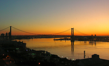
The Benjamin Franklin Bridge, originally named the Delaware River Bridge and known locally as the Ben Franklin Bridge, is a suspension bridge across the Delaware River connecting Philadelphia, Pennsylvania, and Camden, New Jersey. Owned and operated by the Delaware River Port Authority, it is one of four primary vehicular bridges between Philadelphia and southern New Jersey, along with the Betsy Ross, Walt Whitman, and Tacony-Palmyra bridges. It carries Interstate 676/ U.S. Route 30, pedestrians/cyclists, and the PATCO Speedline. The bridge was dedicated as part of the 1926 Sesquicentennial Exposition, celebrating the 150th anniversary of the signing of the United States Declaration of Independence. From 1926 to 1929, it had the longest single span of any suspension bridge in the world. History Plans for a bridge to augment the ferries across the Delaware River began as early as 1818, when one plan envisioned using Smith Island, a narrow island off the Philadelp ... [...More Info...] [...Related Items...] OR: [Wikipedia] [Google] [Baidu] |


