|
Navy Yard–Ballpark Station
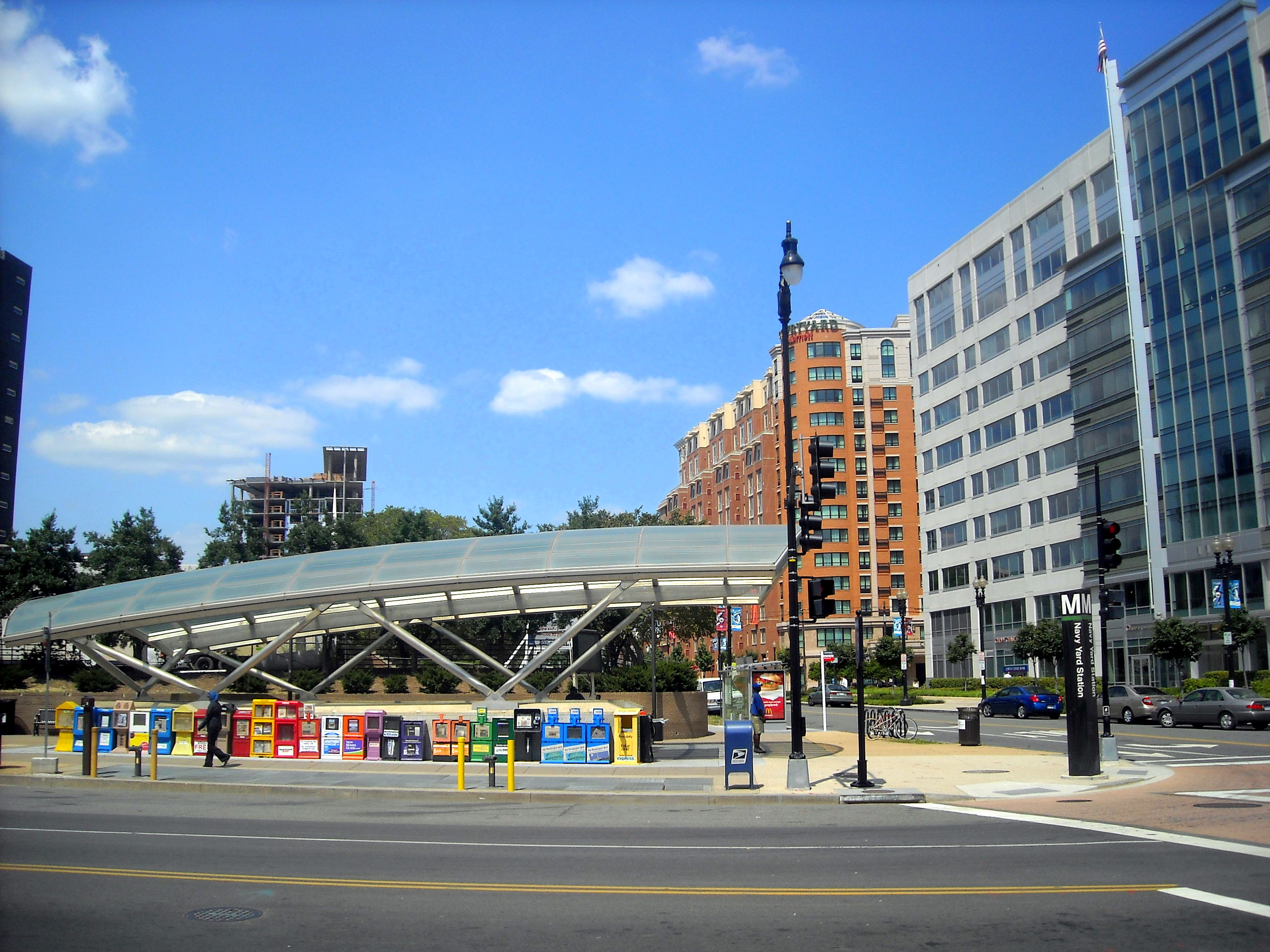
Navy Yard–Ballpark station (also known by its former name, Navy Yard) is a Washington Metro station in Washington, D.C., on the Green Line. The station is located in the Navy Yard/Near Southeast neighborhood of Southeast, with entrances on M Street at Half Street and New Jersey Avenue. Station layout The station uses the island platform layout with two tracks. Track F1 is used by trains to Greenbelt while Branch Avenue-bound trains use track F2. It also features the 22-coffer "waffle" ceiling vault design among , , , , and . Track Maps , by John R. Cambron, Retrieved September 11, 2008 History A station serving the Navy Yard area existed in original plans for Metro; however, the routing of the Green Line below proved controversial. In 1976, the original routing was rejected as too costly and disruptive. A new study propo ...[...More Info...] [...Related Items...] OR: [Wikipedia] [Google] [Baidu] |
M Street (Washington, D
M Street or "M" Street is the thirteenth of a sequence of alphabetical streets in many cities (or the twelfth if "I" or "J" is omitted). It may refer to: * M Street (Washington, D.C.) (3 such streets) * Greenland Hills, Dallas, also known as ''M Streets'' * M. Street, South Korean music group See also * M Street Bridge (other), regarding M Streets in Sacramento, California, and in Washington, D.C. * M Street High School, Washington, D.C. {{disambiguation ... [...More Info...] [...Related Items...] OR: [Wikipedia] [Google] [Baidu] |
Congress Heights (Washington Metro)
Congress Heights station is an island-platformed Washington Metro station situated in the Congress Heights neighborhood of Washington, D.C., United States. Opened on January 13, 2001, the station is operated by the Washington Metropolitan Area Transit Authority (WMATA). Serving only the Green Line, it is positioned at the intersection of Alabama Avenue and 13th Street, beneath St. Elizabeths Hospital. Congress Heights marks the last station of the Green Line in the District of Columbia as it extends southeastward into Prince George's County. Groundbreaking for the final segment of the Green Line occurred on September 23, 1995, and Congress Heights station officially opened on January 13, 2001. Its opening coincided with the completion of approximately of rail southeast of Anacostia, as well as the opening of Branch Avenue, Suitland, Naylor Road, Southern Avenue. Congress Heights is the closest metro station to the CareFirst Arena, home to the Washington Mystics of th ... [...More Info...] [...Related Items...] OR: [Wikipedia] [Google] [Baidu] |
Major League Baseball
Major League Baseball (MLB) is a professional baseball league composed of 30 teams, divided equally between the National League (baseball), National League (NL) and the American League (AL), with 29 in the United States and 1 in Canada. MLB is one of the major professional sports leagues in the United States and Canada and is considered the premier professional baseball league in the world. Each team plays 162 games per season, with Opening Day traditionally held during the first week of April. Six teams in each league then advance to a four-round Major League Baseball postseason, postseason tournament in October, culminating in the World Series, a best-of-seven championship series between the two league champions first played in 1903. MLB is headquartered in Midtown Manhattan. Formed in 1876 and 1901, respectively, the NL and AL cemented their cooperation with the National Agreement in 1903, making MLB the oldest major professional sports league in the world. They remained le ... [...More Info...] [...Related Items...] OR: [Wikipedia] [Google] [Baidu] |
Washington Navy Yard
The Washington Navy Yard (WNY) is a ceremonial and administrative center for the United States Navy, located in the federal national capital city of Washington, D.C. (federal District of Columbia). It is the oldest shore establishment / base of the United States Navy, established 1799, situated along the north shore of the Anacostia River (Eastern Branch of the Potomac River) in the adjacent Navy Yard (Washington, D.C.), Navy Yard neighborhood of Southeast, Washington, D.C. Formerly operating as a shipyard since the end of the 18th century / beginning of the 19th century, and Weapon, ordnance plant, the yard currently serves as home to the Chief of Naval Operations (CNO), commanding the U.S. Navy, and is headquarters for the several military agencies and commands of: Naval Sea Systems Command, Naval Reactors, Naval Facilities Engineering Systems Command, Naval History and Heritage Command, Commander, Navy Installations Command, Navy Installations Command, the National Museum of ... [...More Info...] [...Related Items...] OR: [Wikipedia] [Google] [Baidu] |
Navy Yard Metro Station - Baseball Crowd
A navy, naval force, military maritime fleet, war navy, or maritime force is the branch of a nation's armed forces principally designated for naval and amphibious warfare; namely, lake-borne, riverine, littoral, or ocean-borne combat operations and related functions. It includes anything conducted by surface ships, amphibious ships, submarines, and seaborne aviation, as well as ancillary support, communications, training, and other fields. The strategic offensive role of a navy is projection of force into areas beyond a country's shores (for example, to protect sea-lanes, deter or confront piracy, ferry troops, or attack other navies, ports, or shore installations). The strategic defensive purpose of a navy is to frustrate seaborne projection-of-force by enemies. The strategic task of a navy also may incorporate nuclear deterrence by use of submarine-launched ballistic missiles. Naval operations can be broadly divided between riverine and littoral applications (brown-water na ... [...More Info...] [...Related Items...] OR: [Wikipedia] [Google] [Baidu] |
Audi Field
Audi Field is a soccer-specific stadium in the Buzzard Point neighborhood of Washington, D.C. It is the home of D.C. United, DC Power FC, and Washington Spirit soccer teams, and the DC Defenders American football team. The stadium seats 20,000 people. Previously, D.C. United had explored sites in the Washington metropolitan area. Following the failure of an initial stadium proposal in 2006, D.C. United made two additional stadium proposals that also failed to be built. In January 2011, the club explored using previously unused land at Buzzard Point to build a stadium; this was confirmed in July 2013, when Buzzard Point was announced as the stadium location. The ground-breaking ceremony occurred in February 2017, with construction completed in July 2018. Site selection Early proposals D.C. United and Major League Soccer commissioner Don Garber raised concerns about scheduling conflicts with the Washington Nationals at RFK Stadium in July 2004, with Garber stating that a soccer-sp ... [...More Info...] [...Related Items...] OR: [Wikipedia] [Google] [Baidu] |
Nationals Park
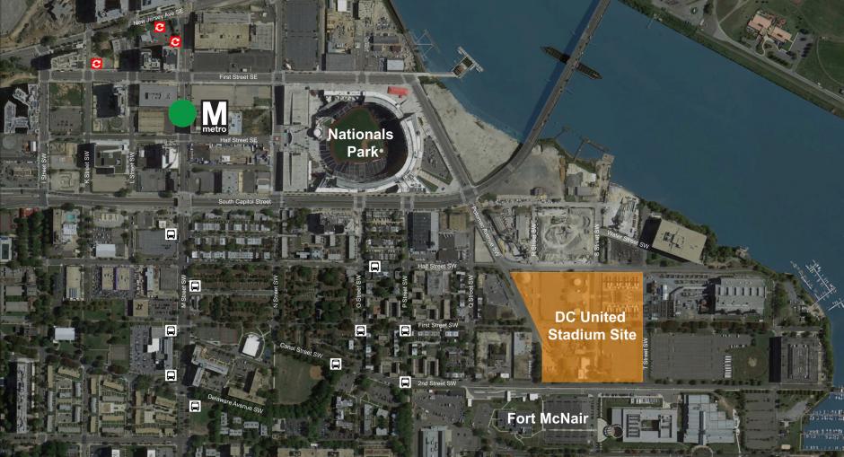
Nationals Park is a baseball stadium along the Anacostia River in the Navy Yard (Washington, D.C.), Navy Yard neighborhood of Washington, D.C. It is the ballpark of Major League Baseball's Washington Nationals. Since its completion in 2008, it was the first LEED-certified green building, green major professional sports stadium in the United States. Designed by Populous (company), HOK Sport and Paul S. Devrouax, Devrouax & Purnell Architects and Planners, the ballpark was initially expected to cost United States dollar, $670 million, with a later price tag of United States dollar, $693 million to build, financed almost entirely by D.C. This amount included $135 million in an upfront payment from taxpayer funds. The rest of the sum, about $535 million dollars, was funded by municipal bonds, putting the city deeply into debt. An additional $84.2 million was spent on transportation, art, and infrastructure upgrades, bringing the total cost to $783.9 million. The stadium has a capacity ... [...More Info...] [...Related Items...] OR: [Wikipedia] [Google] [Baidu] |
Washington Nationals
The Washington Nationals are an American professional baseball team based in Washington, D.C. The Nationals compete in Major League Baseball (MLB) as a member club of the National League (NL) East Division. They play their home games at Nationals Park, located on South Capitol Street in the Navy Yard neighborhood of the Southeast quadrant of D.C. along the Anacostia River. The Nationals are the eighth major league franchise to be based in Washington, D.C., and the first since 1971. The current franchise was founded in 1969 as the Montreal Expos as part of a four-team expansion. After a failed contraction plan, MLB bought the Expos, seeking to move the team to a new city. MLB owners chose Washington, D.C., in 2004 and established the Nationals the next year, in the first MLB franchise move since 1971 when the third Washington Senators moved to Arlington, Texas, to become the Texas Rangers. No other MLB team would move until the 2025 season, when the Oakland Athleti ... [...More Info...] [...Related Items...] OR: [Wikipedia] [Google] [Baidu] |
Waterfront (Washington Metro)
Waterfront station (known as Waterfront–SEU from 1997 to 2011) is a Washington Metro station on the Green Line in the Southwest Waterfront neighborhood of Washington, D.C., United States. The station was opened on December 28, 1991, and is operated by the Washington Metropolitan Area Transit Authority (WMATA). Waterfront is located in the Southwest Waterfront neighborhood at the intersection of 4th and M Streets SW. Notable places nearby * Arena Stage * Fort Lesley McNair * Titanic Memorial * The Wharf History Much of the physical construction of the station was complete by 1980, and its opening was initially to occur in 1983. However, due to litigation surrounding where the line would terminate in Prince George's County, planning and construction of the Green Line halted in 1981 and would not resume until 1985. The station opened on December 28, 1991, and coincided with the completion of approximately of rail southeast of the L'Enfant Plaza station and the opening o ... [...More Info...] [...Related Items...] OR: [Wikipedia] [Google] [Baidu] |
Injunction
An injunction is an equitable remedy in the form of a special court order compelling a party to do or refrain from doing certain acts. It was developed by the English courts of equity but its origins go back to Roman law and the equitable remedy of the "interdict". "When a court employs the extraordinary remedy of injunction, it directs the conduct of a party, and does so with the backing of its full coercive powers."'' Nken v. Holder''556 U.S. 418, 428 (2009) (citation and internal quotation marks omitted). A party that fails to comply with an injunction faces criminal or civil penalties, including possible monetary sanctions and even imprisonment. They can also be charged with contempt of court. Rationale The injunction is an equitable remedy that was created by the English courts of equity. Like other equitable remedies, it has traditionally been given when a wrong cannot be effectively remedied by an award of money damages. (The doctrine that reflects this is the req ... [...More Info...] [...Related Items...] OR: [Wikipedia] [Google] [Baidu] |
Navy Yard Metro Entrance
A navy, naval force, military maritime fleet, war navy, or maritime force is the branch of a nation's armed forces principally designated for naval and amphibious warfare; namely, lake-borne, riverine, littoral, or ocean-borne combat operations and related functions. It includes anything conducted by surface ships, amphibious ships, submarines, and seaborne aviation, as well as ancillary support, communications, training, and other fields. The strategic offensive role of a navy is projection of force into areas beyond a country's shores (for example, to protect sea-lanes, deter or confront piracy, ferry troops, or attack other navies, ports, or shore installations). The strategic defensive purpose of a navy is to frustrate seaborne projection-of-force by enemies. The strategic task of a navy also may incorporate nuclear deterrence by use of submarine-launched ballistic missiles. Naval operations can be broadly divided between riverine and littoral applications (brown-water na ... [...More Info...] [...Related Items...] OR: [Wikipedia] [Google] [Baidu] |
United States District Court For The District Of Columbia
The United States District Court for the District of Columbia (in case citations, D.D.C.) is a United States district court, federal district court in Washington, D.C. Along with the United States District Court for the District of Hawaii and the High Court of American Samoa, it also sometimes handles Federal government of the United States, federal issues that arise in the territory of American Samoa, which has no local federal court or United States territorial court, territorial court.https://www.gao.gov/products/GAO-08-1124T U.S. Government Accountability Office. AMERICAN SAMOA: Issues Associated with Some Federal Court Options. September 18, 2008. Retrieved September 7, 2019. Appeals from the District Court are taken to the United States Court of Appeals for the District of Columbia Circuit except for patent claims and claims against the U.S. government under the Tucker Act, which are appealed to the United States Court of Appeals for the Federal Circuit, Federal Circuit ... [...More Info...] [...Related Items...] OR: [Wikipedia] [Google] [Baidu] |


