|
NDBC
The National Data Buoy Center (NDBC) is a part of the National Oceanic and Atmospheric Administration's (NOAA) National Weather Service (NWS). NDBC designs, develops, operates, and maintains a network of data collecting buoys and coastal stations. The NDBC is located in southern Mississippi as a tenant at the John C. Stennis Space Center, a National Aeronautics and Space Administration (NASA) facility. Operations NDBC employs engineers, meteorologists, oceanographers, computer scientists, and other professionals. NDBC provides hourly observations from a network of about 90 buoys and 60 Coastal Marine Automated Network (C-MAN) stations to help meet these needs. All stations measure wind speed, direction, and gust; atmospheric pressure; and air temperature. In addition, all buoy stations, and some C-MAN stations, measure sea surface temperature and wave height and period. Conductivity and water current are measured at selected stations. A new task is the operation of the DART ... [...More Info...] [...Related Items...] OR: [Wikipedia] [Google] [Baidu] |
Deep-ocean Assessment And Reporting Of Tsunamis
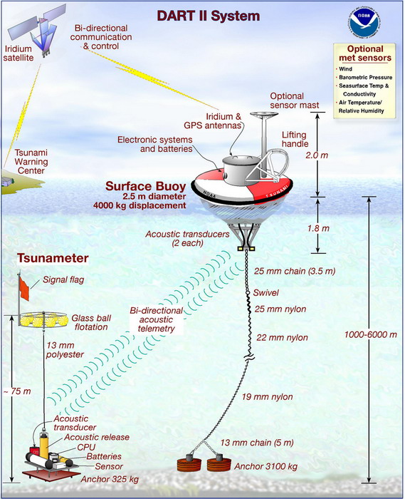
Deep-ocean Assessment and Reporting of Tsunamis (DART) is a component of an enhanced tsunami warning system. By logging changes in seafloor temperature and pressure, and transmitting the data via a surface buoy to a ground station by satellite, DART enables instant, accurate tsunami forecasts. In Standard Mode, the system logs the data at 15-minute intervals, and in Event Mode, every 15 seconds. A 2-way communication system allows the ground station to switch DART into Event Mode whenever detailed reports are needed. Stations Each DART station consists of a surface buoy and a seafloor bottom pressure recording (BPR) package that detects water pressure changes caused by tsunamis. The surface buoy receives transmitted information from the BPR via an acoustic link and then transmits data to a satellite, which retransmits the data to ground stations for immediate dissemination to NOAA's Tsunami Warning Centers, NOAA's National Data Buoy Center, and NOAA's Pacific Marine Environm ... [...More Info...] [...Related Items...] OR: [Wikipedia] [Google] [Baidu] |
Weather Buoy
Weather buoys are instruments which collect weather and ocean data within the world's oceans, as well as aid during emergency response to chemical spills, legal proceedings, and engineering design. Moored buoys have been in use since 1951, while drifting buoys have been used since 1979. Moored buoys are connected with the ocean bottom using either chains, nylon, or buoyant polypropylene. With the decline of the weather ship, they have taken a more primary role in measuring conditions over the open seas since the 1970s. During the 1980s and 1990s, a network of buoys in the central and eastern tropical Pacific Ocean helped study the El Niño-Southern Oscillation. Moored weather buoys range from in diameter, while drifting buoys are smaller, with diameters of . Drifting buoys are the dominant form of weather buoy in sheer number, with 1250 located worldwide. Wind data from buoys has smaller error than that from ships. There are differences in the values of sea surface temperatur ... [...More Info...] [...Related Items...] OR: [Wikipedia] [Google] [Baidu] |
National Weather Service
The National Weather Service (NWS) is an Government agency, agency of the Federal government of the United States, United States federal government that is tasked with providing weather forecasts, warnings of hazardous weather, and other weather-related products to organizations and the public for the purposes of protection, safety, and general information. It is a part of the National Oceanic and Atmospheric Administration (NOAA) branch of the United States Department of Commerce, Department of Commerce, and is headquartered in Silver Spring, Maryland, Silver Spring, Maryland, within the Washington metropolitan area. The agency was known as the United States Weather Bureau from 1890 until it adopted its current name in 1970. The NWS performs its primary task through a collection of national and regional centers, and 122 local List of National Weather Service Weather Forecast Offices, Weather Forecast Offices (WFOs). As the NWS is an agency of the U.S. federal government, most o ... [...More Info...] [...Related Items...] OR: [Wikipedia] [Google] [Baidu] |
Tropical Atmosphere Ocean Project
The Tropical Atmosphere Ocean (TAO) project is a major international effort that instrumented the entire tropical Pacific Ocean with approximately 70 deep ocean Mooring (oceanography), moorings. The development of the TAO array in 1985 was motivated by the 1982-1983 El Niño event and ultimately designed for the study of year-to-year climate variations related to Southern Oscillation, El Niño and the Southern Oscillation (ENSO). Led by the TAO Project Office of the Pacific Marine Environmental Laboratory, Pacific Marine Environmental Laboratory (PMEL), the full array of 70 moorings was completed in 1994. The completed TAO array provides in-situ data collection of high quality oceanographic and surface meteorological data for monitoring, forecasting, and understanding of climate swings associated with El Niño and La Nina. In January 2000, the TAO array was renamed the TAO/TRITON array in recognition of the contribution made by the TRITON (Triangle Trans-Ocean Buoy Network) mooring ... [...More Info...] [...Related Items...] OR: [Wikipedia] [Google] [Baidu] |
Coastal Marine Automated Network
The Coastal-Marine Automated Network (C-MAN) is a meteorological observation network along the coastal United States. Consisting of about sixty stations installed on lighthouses, at capes and beaches, on near shore islands, and on offshore platforms, the stations record atmospheric pressure, wind direction, speed and gust, and air temperature; however, some C-MAN stations are designed to also measure sea surface temperature, water level, waves, relative humidity, precipitation, and visibility. The network is maintained by the National Data Buoy Center (NDBC) of the National Weather Service (NWS), which is part of National Oceanic and Atmospheric Administration (NOAA), and data is ingested into numerical weather prediction computer models. It was created in the early 1980s to maintain observations that were about to be discontinued by other programs. Data is processed and transmitted similarly to the moored buoy system. In 2002, C-MAN was added to the NOAA Observing System Ar ... [...More Info...] [...Related Items...] OR: [Wikipedia] [Google] [Baidu] |
Buoys
A buoy () is a floating device that can have many purposes. It can be anchored (stationary) or allowed to drift with ocean currents. Types Navigational buoys * Race course marker buoys are used for buoy racing, the most prevalent form of yacht racing and power boat racing. They delimit the course and must be passed to a specified side. They are also used in underwater orienteering competitions. * Emergency wreck buoys provide a clear and unambiguous means of temporarily marking new wrecks, typically for the first 24–72 hours. They are coloured in an equal number of blue and yellow vertical stripes and fitted with an alternating blue and yellow flashing light. They were implemented following collisions in the Dover Strait in 2002 when vessels struck the new wreck of the . * Ice marking buoys mark holes in frozen lakes and rivers so snowmobiles do not drive over the holes. * Large Navigational Buoys (LNB, or Lanby buoys) are automatic buoys over 10 m high equipped with ... [...More Info...] [...Related Items...] OR: [Wikipedia] [Google] [Baidu] |
Sea Surface Temperature
Sea surface temperature (SST), or ocean surface temperature, is the ocean temperature close to the surface. The exact meaning of ''surface'' varies according to the measurement method used, but it is between and below the sea surface. Air masses in the Earth's atmosphere are highly modified by sea surface temperatures within a short distance of the shore. Localized areas of heavy snow can form in bands downwind of warm water bodies within an otherwise cold air mass. Warm sea surface temperatures are known to be a cause of tropical cyclogenesis over the Earth's oceans. Tropical cyclones can also cause a cool wake, due to turbulent mixing of the upper of the ocean. SST changes diurnally, like the air above it, but to a lesser degree. There is less SST variation on breezy days than on calm days. In addition, ocean currents such as the Atlantic Multidecadal Oscillation (AMO), can affect SST's on multi-decadal time scales, a major impact results from the global thermohaline ci ... [...More Info...] [...Related Items...] OR: [Wikipedia] [Google] [Baidu] |
Solar Cell
A solar cell, or photovoltaic cell, is an electronic device that converts the energy of light directly into electricity by the photovoltaic effect, which is a physical and chemical phenomenon.Solar Cells chemistryexplained.com It is a form of photoelectric cell, defined as a device whose electrical characteristics, such as , , or resistance, vary when exposed to light. Individual solar cell devices are often the electrical ... [...More Info...] [...Related Items...] OR: [Wikipedia] [Google] [Baidu] |
Geostationary Operational Environmental Satellite
The Geostationary Operational Environmental Satellite (GOES), operated by the United States' National Oceanic and Atmospheric Administration (NOAA)'s National Environmental Satellite, Data, and Information Service division, supports weather forecasting, severe storm tracking, and meteorology research. Spacecraft and ground-based elements of the system work together to provide a continuous stream of environmental data. The National Weather Service (NWS) and the Meteorological Service of Canada use the GOES system for their North American weather monitoring and forecasting operations, and scientific researchers use the data to better understand land, atmosphere, ocean, and climate dynamics. The GOES system uses geosynchronous equatorial satellites that, since the launch of SMS-1 in 1974, have been a basic element of U.S. weather monitoring and forecasting. The procurement, design, and manufacture of GOES satellites is overseen by NASA. NOAA is the official provider of both GOES ... [...More Info...] [...Related Items...] OR: [Wikipedia] [Google] [Baidu] |
Wea02616 - Flickr - NOAA Photo Library
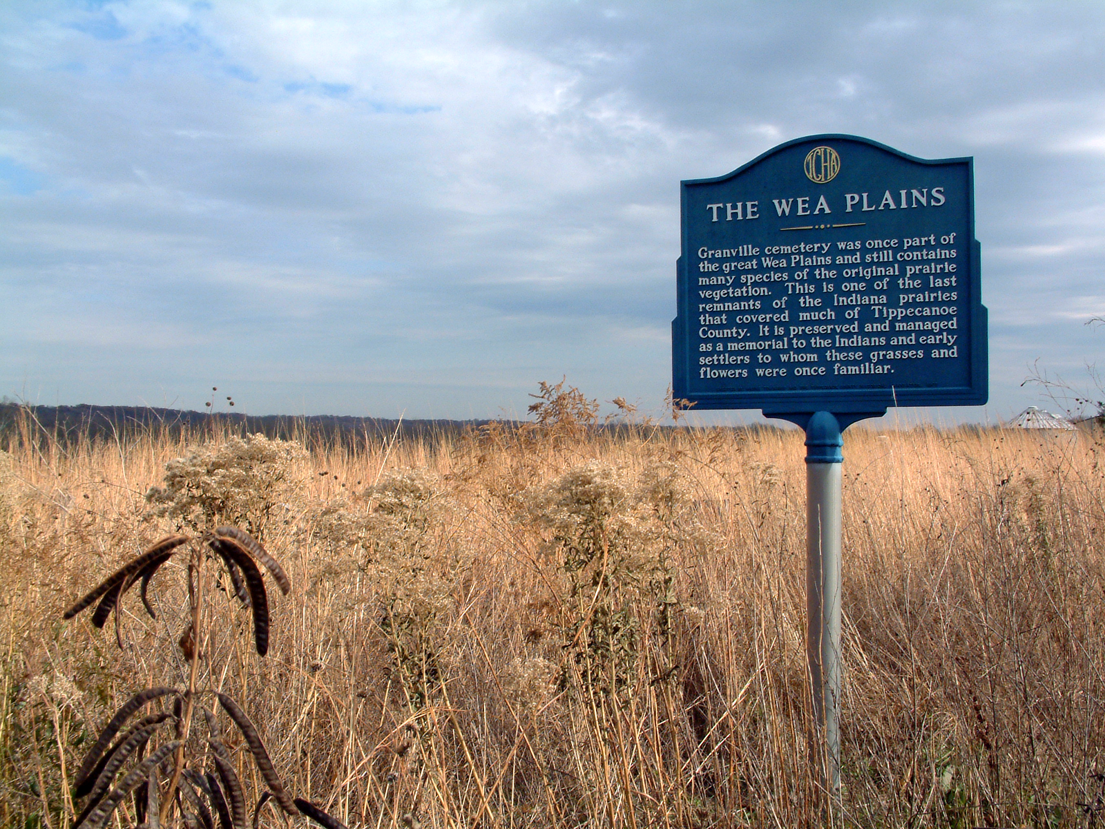
The Wea were a Miami-Illinois language, Miami-Illinois-speaking Native Americans in the United States, Native American tribe originally located in western Indiana. Historically, they were described as either being closely related to the Miami Tribe or a sub-tribe of Miami. Today, the descendants of the Wea, along with the Kaskaskia, Piankeshaw, and Peoria people, Peoria, are enrolled in the Peoria Tribe of Indians of Oklahoma, a federally recognized tribe in Oklahoma. Name The name ''Wea'' is used today as the a shortened version of their numerous recorded names. The Wea name for themselves (autonym) in their own language is ''waayaahtanwa'', derived from ''waayaahtanonki'', 'place of the whirlpool', where they were first recorded being seen and where they were living at that time. The many different spellings of the tribe's name include Waiatanwa, Ouaouiatanoukak, Aoiatenon, Aouciatenons, Ochiatenens, Ouatanons, Ouias, Ouiatanon, Wah-we-ah-tung-ong, Warraghtinooks, and Wya ... [...More Info...] [...Related Items...] OR: [Wikipedia] [Google] [Baidu] |
Wallops Island, Virginia
Wallops Island is a island in Accomack County, Virginia, part of the Virginia Barrier Islands that stretch along the eastern seaboard of the United States of America. It is just south of Chincoteague Island, a popular tourist destination. Wallops Island proper, originally known as Kegotank Island, was granted to John Wallop by the Crown on April 29, 1692. Ownership was divided through the years, until the Commonwealth of Virginia seized the property in 1876 and 1877 in lieu of unpaid taxes. From 1877, ownership was again divided and subdivided until 1889, when it was held by various trustees for the Wallops Island Club. The Club was incorporated and assumed ownership in 1933 as the Wallops Island Association, Inc. Association members and their families spent the summers fishing and swimming on the island. The Association grazed sheep, cattle, and ponies on the area until the mid-1940s. In 1947, the U.S. Navy began using the upper two-thirds of the island on a lease-rental basis ... [...More Info...] [...Related Items...] OR: [Wikipedia] [Google] [Baidu] |


