|
Moussoro
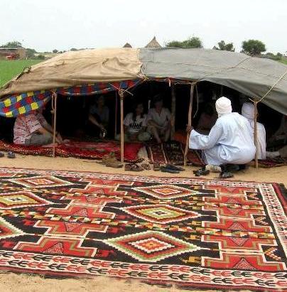
Moussoro ( ar, موسورو) is a town in Chad, lying northeast of N'Djamena on the road to Faya-Largeau. An important transportation centre, it lies in a dry river bed and as a result has more vegetation than is typical in the area. Moussoro is the capital of the region of Barh El Gazel (Bahr el Gazel). The town is served by Moussoro Airport. Moussoro is inhabited by Gouran (Krreda)(Karra) ethnic group of northern Chad. It serves as their commercial and administrative town. Moussoro market day is Thursday. They mostly known by their agricultural activity. Moussoro have the second president's residence in Chad after the main Residence in N'djamena (''see image below''). The town is also the main area for army training in Chad. Gallery File:BEG moussoro2.jpg, Nomadic tent near Moussoro (2012 photograph) File:Making Tea.jpg, Man pouring tea (2015) File:Camel Market.jpg, Weekly camel market (March 2011) References {{reflist , refs = {{cite web , url = http://www.estis.n ... [...More Info...] [...Related Items...] OR: [Wikipedia] [Google] [Baidu] |
Moussoro Airport
Moussoro Airport ( ar, مطار موسورو) is a public use airport located east-northeast of Moussoro, Bahr el Gazel, Chad. See also *List of airports in Chad This is a list of airports in Chad, grouped by type and sorted by location. Chad, officially known as the Republic of Chad (french: République du Tchad, ar, جمهورية تشاد or ''Jumhūriyyat Tshād''), is a landlocked country in Central ... References External links Airport record for Moussoro Airportat Landings.com Airports in Chad Bahr el Gazel Region {{Chad-airport-stub ... [...More Info...] [...Related Items...] OR: [Wikipedia] [Google] [Baidu] |
Bahr El Gazel (region Of Chad)
Barh El Gazel ( ar, منطقة بحر الغزال, french: Région du Barh El Gazel) is one of the 23 regions of Chad. The region's name may also be written as Barh El Gazal or Bahr el Gazel. Its capital is the town of Moussoro. The region was created in 2008 from the former Barh El Gazel Department of the Kanem Region. Geography The region borders Borkou Region to the north, Batha Region to the east, Hadjer-Lamis Region to the south, and Kanem Region to the west. The region is predominantly grassland, merging into the Sahara Desert in the north. Settlements Moussoro is the regional capital; other major settlements include Chadra, Dourgoulanga, Michemiré and Salal. Demographics As per the census of 2009, the population of the region was 260,865, 46.3% female. The average size of household as of 2009 is 5.90: 5.90 in rural households and 5.80 in urban areas. The total number of households was 43,478: 38,160 in rural areas and 5,318 in urban areas. The number of nomads in ... [...More Info...] [...Related Items...] OR: [Wikipedia] [Google] [Baidu] |
Departments Of Chad
The regions of Chad are divided into 61 Department (country subdivision), departments. The departments are listed below, by name and by region. Departments sorted by name Departments grouped by region The following is a list of departments grouped by Regions of Chad, region. Shown next to each department is its population as of 2009, the name of its capital city, capital or main town (''chef-lieu'' in French), and a list of Sub-prefectures of Chad, sub-prefectures (''sous-préfectures''). Bahr el Gazel (region of Chad), Bahr El Gazel Created in 2008 from the Kanem Region, Kanem region's former Barh El Gazel Department, Barh El Gazel department. Batha Region, Batha Borkou Region, Borkou Created in 2008 from the Borkou-Ennedi-Tibesti Region, Borkou-Ennedi-Tibesti region's former Borkou Department, Borkou department. Chari-Baguirmi Region, Chari-Baguirmi Ennedi-Est Region, Ennedi-Est Ennedi-Ouest Region, Ennedi-Ouest Guéra Region, Guéra Hadjer- ... [...More Info...] [...Related Items...] OR: [Wikipedia] [Google] [Baidu] |
Regions Of Chad
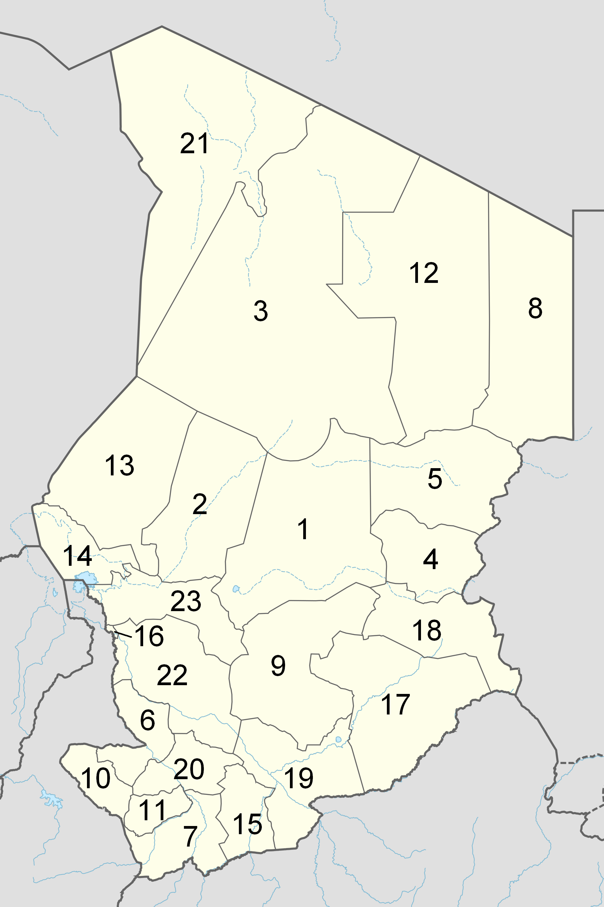
The Republic of Chad is made up of twenty-three regions. Chad was divided into regions in 2002. It was previously divided into prefectures, and then departments. Current regions This is a list of the regions of Chad since 2012, with population figures from the 2009 census. History From independence in 1960 until 1999 it was divided into 14 ''préfectures''. These were replaced in 1999 by 28 ''départements''. The country was reorganized again in 2002 to produce 18 ''régions''. In 2008, a further four ''régions'' were created, increasing the number to 22. Ennedi Region was split into Ennedi-Est and Ennedi-Ouest in 2012, producing the current 23 regions. Regions (2008–2012) Regions (2002–2008) (1) created in 2004 Regions created in 2008 On February 19, 2008, four new regions were created: * Former Borkou-Ennedi-Tibesti Region divided into: ** Borkou Region, from Borkou-Ennedi-Tibesti's former Borkou Department ** Ennedi Region, from Borkou-Ennedi-Ti ... [...More Info...] [...Related Items...] OR: [Wikipedia] [Google] [Baidu] |
Sub-prefectures Of Chad
The departments of Chad are divided into 348 sub-prefectures (''sous-préfectures''). List of sub-prefectures by department and by region * The following is a list of departments grouped by region. Shown next to each department is its population as of 2009, the name of its capital or main town (''chef-lieu'' in French), and a list of sub-prefectures (''sous-préfectures''). Bahr El Gazel Created in 2008 from the Kanem region's former Barh El Gazel department. Batha Borkou Created in 2008 from the Borkou-Ennedi-Tibesti region's former Borkou department. Chari-Baguirmi Ennedi Created in 2008 from the Borkou-Ennedi-Tibesti region's former Ennedi Est and Ennedi Ouest departments. Guéra Hadjer-Lamis Kanem Lac Logone Occidental Logone Oriental Mandoul Mayo-Kebbi Est Mayo-Kebbi Ouest Moyen-Chari Ouaddaï Salamat Sila Created in 2008 from the Ouaddaï region's former Sila and Djourf Al Ahmar depa ... [...More Info...] [...Related Items...] OR: [Wikipedia] [Google] [Baidu] |
Chad
Chad (; ar, تشاد , ; french: Tchad, ), officially the Republic of Chad, '; ) is a landlocked country at the crossroads of North and Central Africa. It is bordered by Libya to the north, Sudan to the east, the Central African Republic to the south, Cameroon to the southwest, Nigeria to the southwest (at Lake Chad), and Niger to the west. Chad has a population of 16 million, of which 1.6 million live in the capital and largest city of N'Djamena. Chad has several regions: a desert zone in the north, an arid Sahelian belt in the centre and a more fertile Sudanian Savanna zone in the south. Lake Chad, after which the country is named, is the second-largest wetland in Africa. Chad's official languages are Arabic and French. It is home to over 200 different ethnic and linguistic groups. Islam (55.1%) and Christianity (41.1%) are the main religions practiced in Chad. Beginning in the 7th millennium BC, human populations moved into the Chadian basin in great numbe ... [...More Info...] [...Related Items...] OR: [Wikipedia] [Google] [Baidu] |
N'Djamena
N'Djamena ( ) is the capital and largest city of Chad. It is also a special statute region, divided into 10 districts or ''arrondissements''. The city serves as the centre of economic activity in Chad. Meat, fish and cotton processing are the chief industries, and it is a regional market for livestock, salt, dates, and grains. It is a port city located at the confluence of the Logone River with the Chari River, forming a transborder agglomeration with the city of Kousséri (in Cameroon), capital of the Department of Logone-et-Chari, which is on the west bank of both rivers. It had 1,093,492 inhabitants in 2013. History N'Djamena was founded as Fort-Lamy by French commander Émile Gentil on 29 May 1900, and named after Amédée-François Lamy, an army officer who had been killed in the Battle of Kousséri about a month earlier. It was a major trading city and became the capital of the region and nation. During the Second World War, the French relied upon the city's airpor ... [...More Info...] [...Related Items...] OR: [Wikipedia] [Google] [Baidu] |
Faya-Largeau
Faya-Largeau (also known as Faya, ar, فايا لارجو or ) is the largest city in northern Chad and was the capital of the region of Bourkou-Ennedi-Tibesti. It is now in the Borkou Region, which was formed in 2008 from the Borkou Department of the former Bourkou-Ennedi-Tibesti region. History Originally called ''Faya'', the town was renamed ''Largeau'' after French Colonel Victor Emmanuel Largeau; upon Chadian independence from France, it assumed the name ''Faya-Largeau''. The town was captured by Libya when Libya annexed the Aouzou Strip in 1975, but was retaken by Hissène Habré's forces in 1980. Libya recaptured Faya-Largeau in 1983, but retreated in 1987. Economy Due to the considerable underground water supply in the town, the main economic activities are agriculture and natron mining. The town is serviced by Faya-Largeau Airport with a paved runway, used almost exclusively by military airplanes. Demographics Climate Faya-Largeau has a hot desert climate typical ... [...More Info...] [...Related Items...] OR: [Wikipedia] [Google] [Baidu] |
River Bed
A stream bed or streambed is the bottom of a stream or river (bathymetry) or the physical confine of the normal water flow (channel). The lateral confines or channel margins are known as the stream banks or river banks, during all but flood stage. Under certain conditions a river can branch from one stream bed to multiple stream beds. A flood occurs when a stream overflows its banks and flows onto its flood plain. As a general rule, the bed is the part of the channel up to the normal water line, and the banks are that part above the normal water line. However, because water flow varies, this differentiation is subject to local interpretation. Usually, the bed is kept clear of terrestrial vegetation, whereas the banks are subjected to water flow only during unusual or perhaps infrequent high water stages and therefore might support vegetation some or much of the time. The nature of any stream bed is always a function of the flow dynamics and the local geologic materials, influ ... [...More Info...] [...Related Items...] OR: [Wikipedia] [Google] [Baidu] |
Vegetation
Vegetation is an assemblage of plant species and the ground cover they provide. It is a general term, without specific reference to particular taxa, life forms, structure, spatial extent, or any other specific botanical or geographic characteristics. It is broader than the term ''flora'' which refers to species composition. Perhaps the closest synonym is plant community, but ''vegetation'' can, and often does, refer to a wider range of spatial scales than that term does, including scales as large as the global. Primeval redwood forests, coastal mangrove stands, sphagnum bogs, desert soil crusts, roadside weed patches, wheat fields, cultivated gardens and lawns; all are encompassed by the term ''vegetation''. The vegetation type is defined by characteristic dominant species, or a common aspect of the assemblage, such as an elevation range or environmental commonality. The contemporary use of ''vegetation'' approximates that of ecologist Frederic Clements' term earth cover, a ... [...More Info...] [...Related Items...] OR: [Wikipedia] [Google] [Baidu] |
Capital City
A capital city or capital is the municipality holding primary status in a country, state, province, Department (country subdivision), department, or other subnational entity, usually as its seat of the government. A capital is typically a city that physically encompasses the government's offices and meeting places; the status as capital is often designated by its law or constitution. In some jurisdictions, including several countries, different branches of government are in different settlements. In some cases, a distinction is made between the official (constitutional) capital and the seat of government, which is List of countries with multiple capitals, in another place. English language, English-language news media often use the name of the capital city as an alternative name for the government of the country of which it is the capital, as a form of metonymy. For example, "relations between Washington, D.C., Washington and London" refer to "United Kingdom–United States rel ... [...More Info...] [...Related Items...] OR: [Wikipedia] [Google] [Baidu] |


