|
Mount Gelai
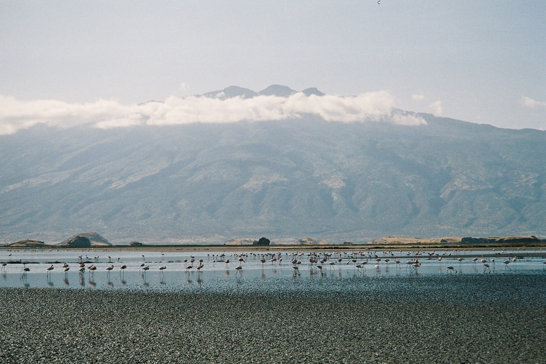
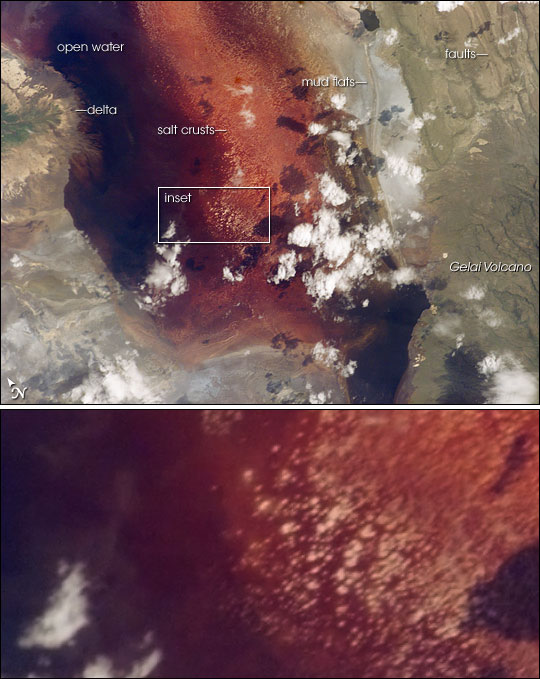
Gelai Volcano also known as Mount Gelai stands at tall and is located in Ngorongoro District, Arusha Region, Tanzania in the Crater Highlands. It is at the southeastern edge of Lake Natron in the East African Rift. Gelai is the third most prominent peak in Arusha Region and is the 13th highest peak in Arusha region. Volcanic activity on Gelai dates to less than one million years ago. A number of earthquakes occurred in the area in the summer of 2007. Associated with the largest earthquake on 17 July a NNE-oriented fracture or narrow graben formed on the southern flank of Gelai. The fracture may be associated with the intrusion of a narrow dike at a depth of around . The volcano falls within a game-controlled area that extends east to Longido District, within Arusha Region, where strict regulated hunting is permitted. This has caused an increase in the numbers of animals in the area due to anti poaching efforts provided by revenue from licensed hunters. See also *List of vol ... [...More Info...] [...Related Items...] OR: [Wikipedia] [Google] [Baidu] |
Ngorongoro District
Ngorongoro is one of the seven districts of the Arusha Region in Tanzania. The District covers an area of . It is bordered to the north by Kenya, to the east by Monduli District, the northeast by Longido District, and to the south by the Karatu District. The western border is the Serengeti District in Mara Region. Ngorongoro District is home to the Ngorongoro Crater and was named after it. The administrative seat is the town of Loliondo. The district is home to the Ngorongoro Conservation Area which is a UNESCO World Heritage Site. According to the 2002 Tanzania National Census, the population of the Ngorongoro Region was 129,776. By 2012, the population of the district was 174,278. Within the district are the Ngorongoro Crater and active volcano Ol Doinyo Lengai. The district plays host to parts of the wildebeest migration. While not part of the park, as such, much of the district is within the same Serengeti- Mara Ecosystem, which is defined by the limits of the annual wildli ... [...More Info...] [...Related Items...] OR: [Wikipedia] [Google] [Baidu] |
Arusha Region
Arusha City is a Tanzanian city and the regional capital of the Arusha Region, with a population of 416,442 plus 323,198 in the surrounding Arusha District Council (2012 census). Located below Mount Meru (Tanzania), Mount Meru on the eastern edge of the eastern branch of the East African Rift, Great Rift Valley, Arusha City has a temperate climate. The city is close to the Serengeti National Park, the Ngorongoro Conservation Area, Lake Manyara National Park, Olduvai Gorge, Tarangire National Park, Mount Kilimanjaro, and Mount Meru (Tanzania), Mount Meru in the Arusha National Park. The city is a major international diplomatic hub. It hosts the African Court on Human and Peoples' Rights, African Court of the African Union and is the capital of the East African Community. From 1994 to 2015, the city also hosted the International Criminal Tribunal for Rwanda, but that entity has ceased operations. It is a multicultural city with a majority Tanzanian population of mixed backgroun ... [...More Info...] [...Related Items...] OR: [Wikipedia] [Google] [Baidu] |
Tanzania
Tanzania (; ), officially the United Republic of Tanzania ( sw, Jamhuri ya Muungano wa Tanzania), is a country in East Africa within the African Great Lakes region. It borders Uganda to the north; Kenya to the northeast; Comoro Islands and the Indian Ocean to the east; Mozambique and Malawi to the south; Zambia to the southwest; and Rwanda, Burundi, and the Democratic Republic of the Congo to the west. Mount Kilimanjaro, Africa's highest mountain, is in northeastern Tanzania. According to the United Nations, Tanzania has a population of million, making it the most populous country located entirely south of the equator. Many important hominid fossils have been found in Tanzania, such as 6-million-year-old Pliocene hominid fossils. The genus Australopithecus ranged across Africa between 4 and 2 million years ago, and the oldest remains of the genus ''Homo'' are found near Lake Olduvai. Following the rise of '' Homo erectus'' 1.8 million years ago, humanity spread ... [...More Info...] [...Related Items...] OR: [Wikipedia] [Google] [Baidu] |
Crater Highlands
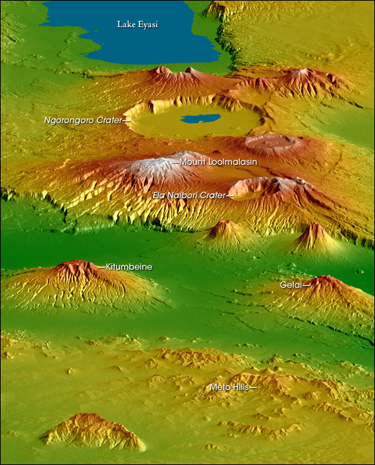
The Crater Highlands (Ngorongoro Highlands) are a geological region along the East African Rift in the Arusha Region and parts of northern Manyara Region in north Tanzania. Geology The highlands are located in a spreading zone at the intersection of branches of two tectonic plates, the African Plate and Somali Plate, resulting in distinctive and prominent landforms. The highlands are named for the many craters and calderas present. As is common in spreading zones, volcanoes can be found here. Magma, rising to fill the gaps, reaches the surface and builds cones. Calderas form if a volcano explodes or collapses, following the emptying of the magma chamber below, and further spreading can fracture the volcanoes as well. Geography The following are considered to be within the Crater Highlands: * Ela Naibori Crater * Gelai Mountain * Kitumbeine Mountain * Lake Eyasi * Meto Hills * Mount Loolmalasin * Ngorongoro Crater Visiting the Crater Highlands There are variety of scenic ... [...More Info...] [...Related Items...] OR: [Wikipedia] [Google] [Baidu] |
Lake Natron
Lake Natron is a salt or alkaline lake located in north Ngorongoro District of Arusha Region in Tanzania. It is in the Gregory Rift, which is the eastern branch of the East African Rift. The lake is within the Lake Natron Basin, a Ramsar Site wetland of international significance. The lake is fed principally by the Southern Ewaso Ng'iro River, which rises in central Kenya, and by mineral-rich hot springs. It is quite shallow, less than deep, and varies in width depending on its water level. The lake is a maximum of long and wide. The surrounding area receives irregular seasonal rainfall, mainly between December and May totalling per year. Temperatures at the lake are frequently above . High levels of evaporation have left behind natron (sodium carbonate decahydrate) and trona (sodium sesquicarbonate dihydrate). The alkalinity of the lake can reach a pH of greater than 12. The surrounding bedrock is composed of alkaline, sodium-dominated trachyte lavas that were laid down ... [...More Info...] [...Related Items...] OR: [Wikipedia] [Google] [Baidu] |
East African Rift
The East African Rift (EAR) or East African Rift System (EARS) is an active continental rift zone in East Africa. The EAR began developing around the onset of the Miocene, 22–25 million years ago. In the past it was considered to be part of a larger Great Rift Valley that extended north to Asia Minor. A narrow zone, the rift is a developing divergent tectonic plate boundary where the African Plate is in the process of splitting into two tectonic plates, called the Somali Plate and the Nubian Plate, at a rate of 6-7 mm per year. The rift system consists of three microplates, the Victoria Microplate to the north, and the Rovuma and Lwandle microplates to the south. The Victoria Microplate is rotating anti-clockwise with respect to the African plate. Its rotation is caused by the configuration of mechanically weaker and stronger lithospheric regions in the EARS. Extent A series of distinct rift basins, the East African Rift System extends over thousands of kilometers. The ... [...More Info...] [...Related Items...] OR: [Wikipedia] [Google] [Baidu] |
Graben
In geology, a graben () is a depressed block of the crust of a planet or moon, bordered by parallel normal faults. Etymology ''Graben'' is a loan word from German, meaning 'ditch' or 'trench'. The word was first used in the geologic context by Eduard Suess in 1883. The plural form is either ''graben'' or ''grabens''. Formation A graben is a valley with a distinct escarpment on each side caused by the displacement of a block of land downward. Graben often occur side by side with horsts. Horst and graben structures indicate tensional forces and crustal stretching. Graben are produced from parallel normal faults, where the displacement of the hanging wall is downward, while that of the footwall is upward. The faults typically dip toward the center of the graben from both sides. Horsts are parallel blocks that remain between graben; the bounding faults of a horst typically dip away from the center line of the horst. Single or multiple graben can produce a rift valley. Half-g ... [...More Info...] [...Related Items...] OR: [Wikipedia] [Google] [Baidu] |
Dike (geology)
A dike or dyke, in Geology, geological usage, is a sheet of rock that is formed in a Fracture (geology), fracture of a pre-existing rock body. Dikes can be either Intrusive rock, magmatic or Sedimentary rock, sedimentary in origin. Magmatic dikes form when magma flows into a crack then solidifies as a sheet intrusion, either cutting across layers of rock or through a contiguous mass of rock. Clastic dikes are formed when sediment fills a pre-existing crack.Essentials of Geology, 3rd Ed, Stephen Marshak Magmatic dikes A magmatic dike is a sheet of igneous rock that cuts across older rock beds. It is formed when magma fills a fracture in the older beds and then cools and solidifies. The dike rock is usually more resistant to weathering than the surrounding rock, so that erosion exposes the dike as a natural wall or ridge. It is from these natural walls that dikes get their name. Dikes preserve a record of the fissures through which most mafic magma (fluid magma low in silica) reac ... [...More Info...] [...Related Items...] OR: [Wikipedia] [Google] [Baidu] |
Longido District
Longido is one of the six districts in the Arusha Region of Tanzania. The District covers an area of . It is bordered to the east by the Ngorongoro District, to the south west by the Monduli District and Southeast by the Arusha Rural District and Meru District. To the far east by Siha District of Kilimanjaro Region and the north by Kenya. Longido District was created in 2007 from Monduli District. Mount Longido is located within the boundaries of the district. The administrative seat is the town of Longido. According to the 2012 census, the population of the district was 123,153. Longido District is known as Arusha's gem district as its home to Anyolite and Rubies. The Maasai are currently the dominant group in the district, whom have migrated to the district from Kenya in the 18th and 19th century. Transport Paved trunk road T2 from Arusha to the Kenyan border town Namanga passes through the district. Administrative subdivisions Constituencies For parliamentary elections, ... [...More Info...] [...Related Items...] OR: [Wikipedia] [Google] [Baidu] |
List Of Volcanoes In Tanzania
A ''list'' is any set of items in a row. List or lists may also refer to: People * List (surname) Organizations * List College, an undergraduate division of the Jewish Theological Seminary of America * SC Germania List, German rugby union club Other uses * Angle of list, the leaning to either port or starboard of a ship * List (information), an ordered collection of pieces of information ** List (abstract data type), a method to organize data in computer science * List on Sylt, previously called List, the northernmost village in Germany, on the island of Sylt * ''List'', an alternative term for ''roll'' in flight dynamics * To ''list'' a building, etc., in the UK it means to designate it a listed building that may not be altered without permission * Lists (jousting), the barriers used to designate the tournament area where medieval knights jousted * ''The Book of Lists'', an American series of books with unusual lists See also * The List (other) * Listing ... [...More Info...] [...Related Items...] OR: [Wikipedia] [Google] [Baidu] |


