|
Mortar, Bihar
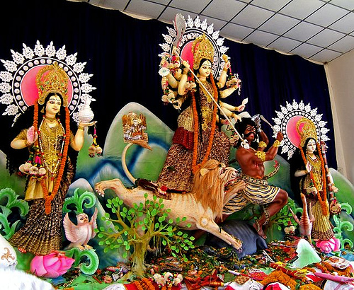
Mortar is a village in the Garhpura block of Begusarai district in the Indian state of Bihar about north of district capital, Begusarai. The 2011 census gives its population as 1,817. It comes under Malipur Panchayat and under post office Malipur. Facilities As of 2009, the water supply is from wells and hand pumps; there is no tap water. Domestic electricity is available. Primary, middle and secondary schooling is provided within the village. The nearest police station is at Garhpura. Mortar Durga Puja Samiti The annual Durga Puja festival is organised by the Mortar Durga Puja Samiti. A mela takes place in the school ground, when an idol of the goddess Durga is made and people gather together to celebrate. Sweets are bought, new clothes are worn, people offer their prayers, and different types of functions are organised, like Kushti. At night, you can enjoy Jagran along with a play by the Mortar Youth Front. See also * Begusarai Begusarai is the industrial and ... [...More Info...] [...Related Items...] OR: [Wikipedia] [Google] [Baidu] |
States And Territories Of India
India is a federal union comprising 28 states and 8 union territories, with a total of 36 entities. The states and union territories are further subdivided into districts and smaller administrative divisions. History Pre-independence The Indian subcontinent has been ruled by many different ethnic groups throughout its history, each instituting their own policies of administrative division in the region. The British Raj mostly retained the administrative structure of the preceding Mughal Empire. India was divided into provinces (also called Presidencies), directly governed by the British, and princely states, which were nominally controlled by a local prince or raja loyal to the British Empire, which held ''de facto'' sovereignty ( suzerainty) over the princely states. 1947–1950 Between 1947 and 1950 the territories of the princely states were politically integrated into the Indian union. Most were merged into existing provinces; others were organised into ... [...More Info...] [...Related Items...] OR: [Wikipedia] [Google] [Baidu] |
Bihar
Bihar (; ) is a state in eastern India. It is the 2nd largest state by population in 2019, 12th largest by area of , and 14th largest by GDP in 2021. Bihar borders Uttar Pradesh to its west, Nepal to the north, the northern part of West Bengal to the east, and with Jharkhand to the south. The Bihar plain is split by the river Ganges, which flows from west to east. On 15 November 2000, southern Bihar was ceded to form the new state of Jharkhand. Only 20% of the population of Bihar lives in urban areas as of 2021. Additionally, almost 58% of Biharis are below the age of 25, giving Bihar the highest proportion of young people of any Indian state. The official languages are Hindi and Urdu, although other languages are common, including Maithili, Magahi, Bhojpuri and other Languages of Bihar. In Ancient and Classical India, the area that is now Bihar was considered the centre of political and cultural power and as a haven of learning. From Magadha arose India's first empire, ... [...More Info...] [...Related Items...] OR: [Wikipedia] [Google] [Baidu] |
Begusarai District
Begusarai District is one of the thirty-eight districts of the Indian state of Bihar. The city of Begusarai is its administrative headquarters and is part of the Munger division. History Begulsarai was established in 1870 as part of Munger District. In 1972, it was given district status. Simaria village is the birthplace of famous Hindi poet Ramdhari Singh Dinkar. Begusarai is part of the historic Mithila or Mithilanchal region. Begusarai is notable for its milk, sweets and dairy products. Geography Begusarai district occupies an area of , The district lies on the northern bank of the river Ganges. Begusarai district is a part of Munger division. It is located at latitudes 25.15N & 25.45N and longitudes 85.45E & 86.36E. The Ganges river separates Begusarai district from Patna District and Munger District. Flora and Fauna In 1989 Begusarai district became home to the Kanwar Lake Bird Sanctuary Kanwar Lake Bird Sanctuary Wildlife Sanctuary, which has an area of . It is Asia's ... [...More Info...] [...Related Items...] OR: [Wikipedia] [Google] [Baidu] |
Community Development Block
In India, a Community development block (CD block) or simply Block is a sub-division of Tehsil, administratively earmarked for planning and development. The area is administered by a Block Development Officer (BDO), supported by several technical specialists and village-level workers. A community development block covers several gram panchayats, the local administrative units at the village level. Nomenclature Only in the state of West Bengal are CD blocks considered the third level administrative units (equal to tehsils in North India. Elsewhere, tehsils are also called Talukas in the Western Indian states of Goa, Gujarat, Maharashtra and South Indian states of Karnataka, Kerala, and Tamil Nadu. In Arunachal Pradesh and Nagaland, the term Circles are used, while Sub-divisions are present in the Eastern Indian states of Bihar, Jharkhand, Assam, and most of Northeast India (Manipur, Meghalaya, Mizoram, Sikkim and Tripura). In Andhra Pradesh and Telangana, a newer form of admini ... [...More Info...] [...Related Items...] OR: [Wikipedia] [Google] [Baidu] |
Maithili Language
Maithili () is an Indo-Aryan language spoken in parts of Languages of India, India and Languages of Nepal, Nepal. It is native to the Mithila region, which encompasses parts of the Indian states of Bihar and Jharkhand as well as Nepal's eastern Terai. It is one of the 22 Eighth Schedule to the Constitution of India, officially recognised languages of India and the second most spoken Languages of Nepal, Nepalese language in Nepal. The language is predominantly written in Devanagari, but there were two other historically important scripts: Tirhuta script, Tirhuta, which has retained some use until the present, and Kaithi script, Kaithi. Official status In 2003, Maithili was included in the 8th Schedule, Eighth Schedule of the Indian Constitution as a recognised language of India, Indian language, which allows it to be used in education, government, and other official contexts in India. Maithili language is included as an optional paper in the Union Public Service Commission, UP ... [...More Info...] [...Related Items...] OR: [Wikipedia] [Google] [Baidu] |
Hindi Language
Hindi (Devanāgarī: or , ), or more precisely Modern Standard Hindi (Devanagari: ), is an Indo-Aryan language spoken chiefly in the Hindi Belt region encompassing parts of northern, central, eastern, and western India. Hindi has been described as a standardised and Sanskritised register of the Hindustani language, which itself is based primarily on the Khariboli dialect of Delhi and neighbouring areas of North India. Hindi, written in the Devanagari script, is one of the two official languages of the Government of India, along with English. It is an official language in nine states and three union territories and an additional official language in three other states. Hindi is also one of the 22 scheduled languages of the Republic of India. Hindi is the '' lingua franca'' of the Hindi Belt. It is also spoken, to a lesser extent, in other parts of India (usually in a simplified or pidginised variety such as Bazaar Hindustani or Haflong Hindi). Outside India, several ot ... [...More Info...] [...Related Items...] OR: [Wikipedia] [Google] [Baidu] |
Indian Standard Time
Indian Standard Time (IST), sometimes also called India Standard Time, is the time zone observed throughout India, with a time offset of UTC+05:30. India does not observe daylight saving time or other seasonal adjustments. In military and aviation time, IST is designated E* ("Echo-Star"). It is indicated as Asia/Kolkata in the IANA time zone database. History After Independence in 1947, the Union government established IST as the official time for the whole country, although Kolkata and Mumbai retained their own local time (known as Calcutta Time and Bombay Time) until 1948 and 1955, respectively. The Central observatory was moved from Chennai to a location at Shankargarh Fort in Allahabad district, so that it would be as close to UTC+05:30 as possible. Daylight Saving Time (DST) was used briefly during the China–India War of 1962 and the Indo-Pakistani Wars of 1965 and 1971. Calculation Indian Standard Time is calculated from the clock tower in Mirzapur nearly exa ... [...More Info...] [...Related Items...] OR: [Wikipedia] [Google] [Baidu] |

_1_by_N._A._Naseer.jpg)

