|
Mission Range
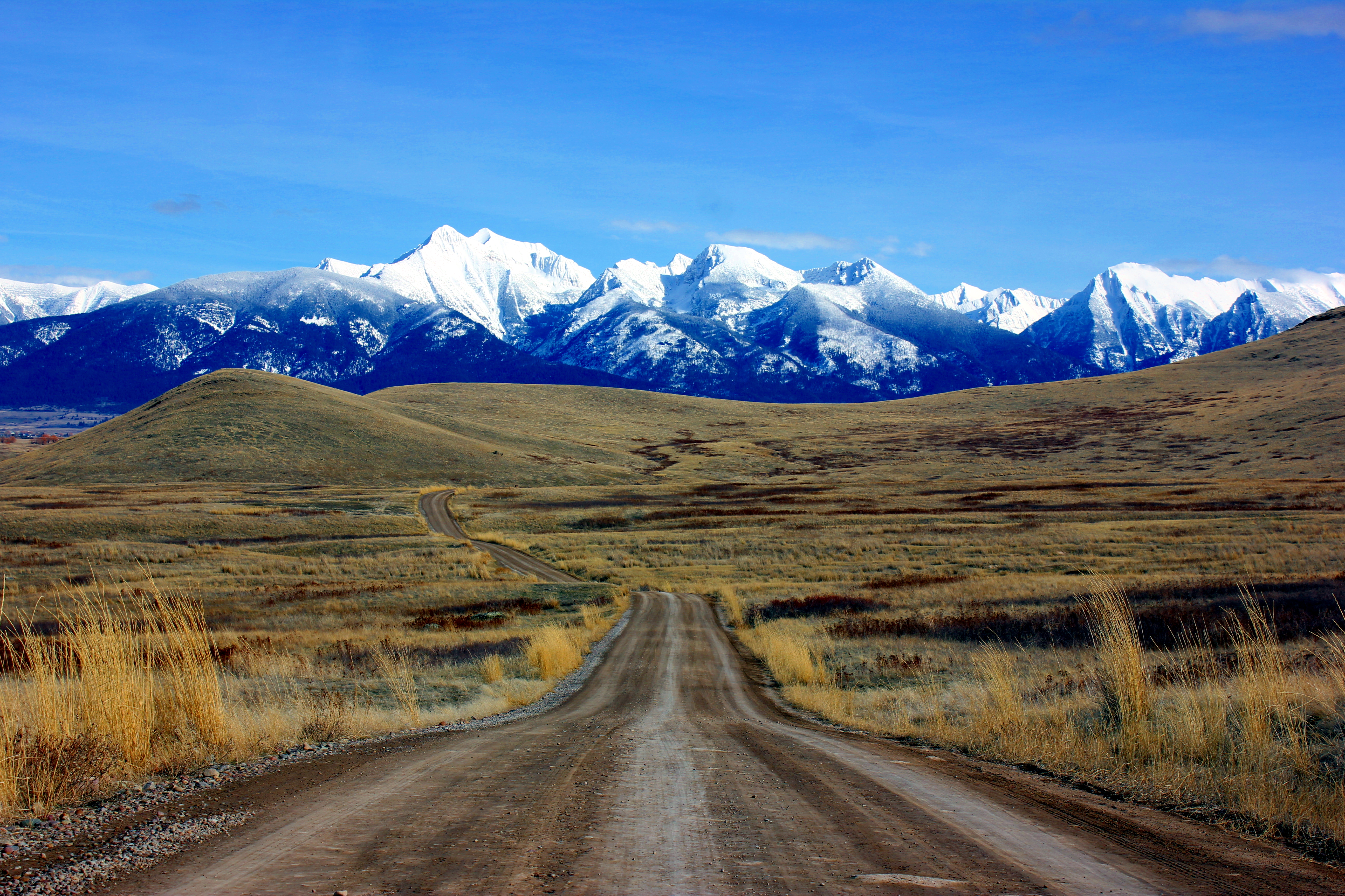
The Mission Mountains or Mission Range are a range of the Rocky Mountains located in northwestern Montana in the United States. They lie chiefly in Lake County, Montana, Lake County and Missoula County, Montana, Missoula County and are south and east of Flathead Lake and west of the Swan Range. On the east side of the range is the Swan River (Montana), Swan River Valley and on the west side the Mission Valley. The highest point in the Mission Mountains is McDonald Peak at . The range is named for its proximity to the Jesuit St. Ignatius Mission, established in the mid-19th century in what is today St. Ignatius, Montana. Geology The Mission Mountains are composed largely of what is called "Belt Rock" from the Belt Supergroup. The sedimentary rocks in this group formed between 1.47 and 1.4 billion years ago in the Belt Basin. The roughly circular Sedimentary basin, basin collected sediments from surrounding areas for millions of years. The basin was eventually buried and later ... [...More Info...] [...Related Items...] OR: [Wikipedia] [Google] [Baidu] |
Montana
Montana () is a state in the Mountain West division of the Western United States. It is bordered by Idaho to the west, North Dakota and South Dakota to the east, Wyoming to the south, and the Canadian provinces of Alberta, British Columbia, and Saskatchewan to the north. It is the fourth-largest state by area, the eighth-least populous state, and the third-least densely populated state. Its state capital is Helena. The western half of Montana contains numerous mountain ranges, while the eastern half is characterized by western prairie terrain and badlands, with smaller mountain ranges found throughout the state. Montana has no official nickname but several unofficial ones, most notably "Big Sky Country", "The Treasure State", "Land of the Shining Mountains", and " The Last Best Place". The economy is primarily based on agriculture, including ranching and cereal grain farming. Other significant economic resources include oil, gas, coal, mining, and lumber. The health ca ... [...More Info...] [...Related Items...] OR: [Wikipedia] [Google] [Baidu] |
Hematite
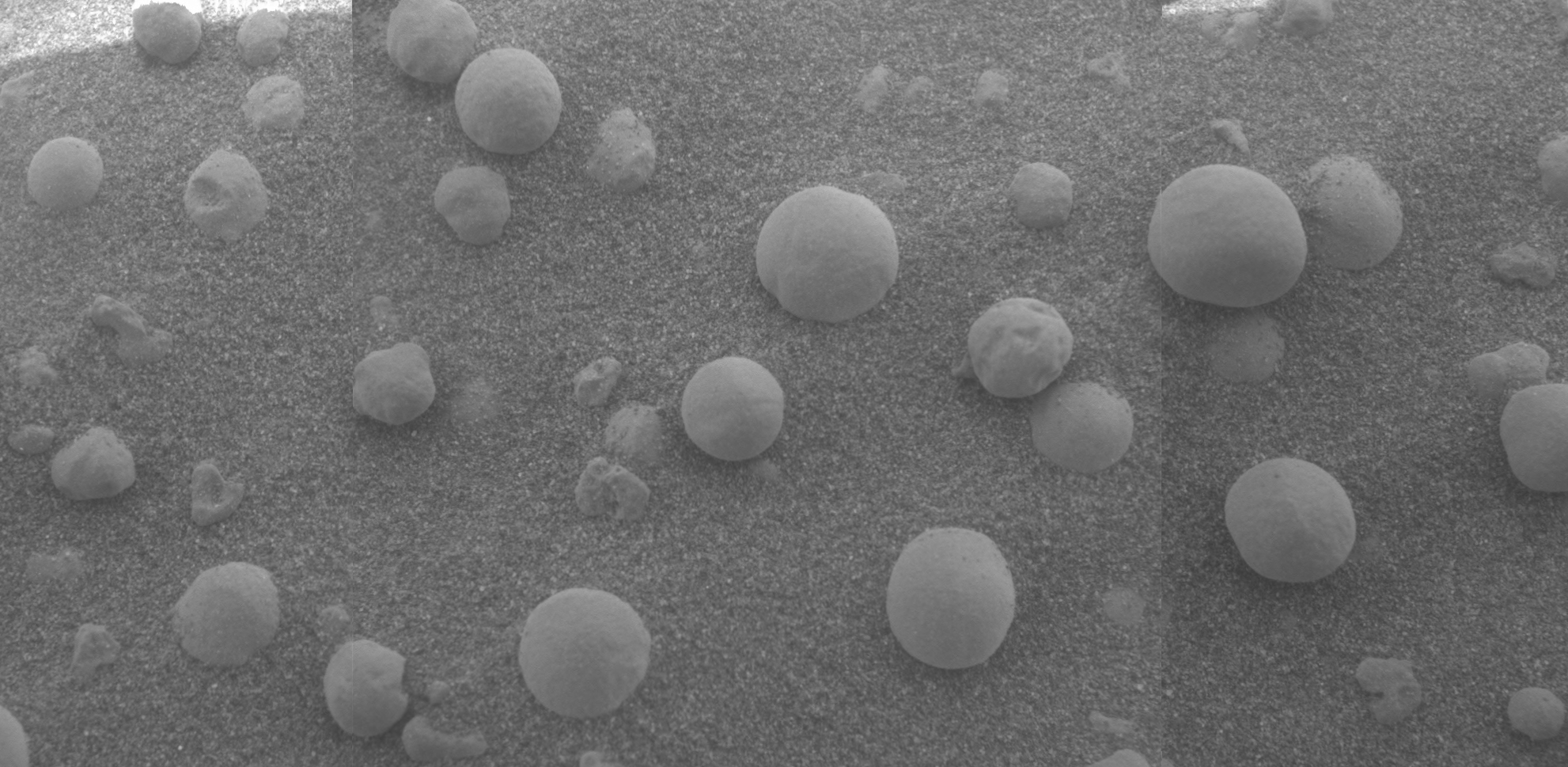
Hematite (), also spelled as haematite, is a common iron oxide compound with the formula, Fe2O3 and is widely found in rocks and soils. Hematite crystals belong to the rhombohedral lattice system which is designated the alpha polymorph of . It has the same crystal structure as corundum () and ilmenite (). With this it forms a complete solid solution at temperatures above . Hematite naturally occurs in black to steel or silver-gray, brown to reddish-brown, or red colors. It is mined as an important ore mineral of iron. It is electrically conductive. Hematite varieties include ''kidney ore'', ''martite'' (pseudomorphs after magnetite), ''iron rose'' and ''specularite'' (specular hematite). While these forms vary, they all have a rust-red streak. Hematite is not only harder than pure iron, but also much more brittle. Maghemite is a polymorph of hematite (γ-) with the same chemical formula, but with a spinel structure like magnetite. Large deposits of hematite are found in ... [...More Info...] [...Related Items...] OR: [Wikipedia] [Google] [Baidu] |
Rocky Mountain Trench
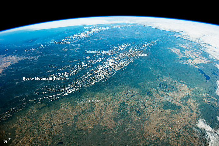
The Rocky Mountain Trench, also known as the Valley of a Thousand Peaks or simply the Trench, is a large valley on the western side of the northern part of North America's Rocky Mountains. The Trench is both visually and cartographically a striking physiographic feature extending approximately from Flathead Lake, Montana, to the Liard River, just south of the British Columbia–Yukon border near Watson Lake, Yukon. The trench bottom is wide and is above sea level. The general orientation of the Trench is an almost straight 150/330° geographic north vector and has become convenient as a visual guide for aviators heading north or south. Although some of its topography has been carved into U-shaped glacial valleys, it is primarily a byproduct of geologic faulting. The Trench separates the Rocky Mountains on its east from the Columbia Mountains and the Cassiar Mountains on its west. It also skirts part of the McGregor Plateau area of the Nechako Plateau sub-area of the ... [...More Info...] [...Related Items...] OR: [Wikipedia] [Google] [Baidu] |
Pleistocene
The Pleistocene ( , often referred to as the ''Ice age'') is the geological Epoch (geology), epoch that lasted from about 2,580,000 to 11,700 years ago, spanning the Earth's most recent period of repeated glaciations. Before a change was finally confirmed in 2009 by the International Union of Geological Sciences, the cutoff of the Pleistocene and the preceding Pliocene was regarded as being 1.806 million years Before Present (BP). Publications from earlier years may use either definition of the period. The end of the Pleistocene corresponds with the end of the last glacial period and also with the end of the Paleolithic age used in archaeology. The name is a combination of Ancient Greek grc, label=none, πλεῖστος, pleīstos, most and grc, label=none, καινός, kainós (latinized as ), 'new'. At the end of the preceding Pliocene, the previously isolated North and South American continents were joined by the Isthmus of Panama, causing Great American Interchang ... [...More Info...] [...Related Items...] OR: [Wikipedia] [Google] [Baidu] |
Glacier
A glacier (; ) is a persistent body of dense ice that is constantly moving under its own weight. A glacier forms where the accumulation of snow exceeds its Ablation#Glaciology, ablation over many years, often Century, centuries. It acquires distinguishing features, such as Crevasse, crevasses and Serac, seracs, as it slowly flows and deforms under stresses induced by its weight. As it moves, it abrades rock and debris from its substrate to create landforms such as cirques, moraines, or fjords. Although a glacier may flow into a body of water, it forms only on land and is distinct from the much thinner sea ice and lake ice that form on the surface of bodies of water. On Earth, 99% of glacial ice is contained within vast ice sheets (also known as "continental glaciers") in the polar regions, but glaciers may be found in mountain ranges on every continent other than the Australian mainland, including Oceania's high-latitude oceanic island countries such as New Zealand. Between lati ... [...More Info...] [...Related Items...] OR: [Wikipedia] [Google] [Baidu] |
Fault (geology)
In geology, a fault is a planar fracture or discontinuity in a volume of rock across which there has been significant displacement as a result of rock-mass movements. Large faults within Earth's crust result from the action of plate tectonic forces, with the largest forming the boundaries between the plates, such as the megathrust faults of subduction zones or transform faults. Energy release associated with rapid movement on active faults is the cause of most earthquakes. Faults may also displace slowly, by aseismic creep. A ''fault plane'' is the plane that represents the fracture surface of a fault. A ''fault trace'' or ''fault line'' is a place where the fault can be seen or mapped on the surface. A fault trace is also the line commonly plotted on geologic maps to represent a fault. A ''fault zone'' is a cluster of parallel faults. However, the term is also used for the zone of crushed rock along a single fault. Prolonged motion along closely spaced faults can blur the ... [...More Info...] [...Related Items...] OR: [Wikipedia] [Google] [Baidu] |
Cenozoic
The Cenozoic ( ; ) is Earth's current geological era, representing the last 66million years of Earth's history. It is characterised by the dominance of mammals, birds and flowering plants, a cooling and drying climate, and the current configuration of continents. It is the latest of three geological eras since complex life evolved, preceded by the Mesozoic and Paleozoic. It started with the Cretaceous–Paleogene extinction event, when many species, including the non-avian dinosaurs, became extinct in an event attributed by most experts to the impact of a large asteroid or other celestial body, the Chicxulub impactor. The Cenozoic is also known as the Age of Mammals because the terrestrial animals that dominated both hemispheres were mammalsthe eutherians (placentals) in the northern hemisphere and the metatherians (marsupials, now mainly restricted to Australia) in the southern hemisphere. The extinction of many groups allowed mammals and birds to greatly diversify so that l ... [...More Info...] [...Related Items...] OR: [Wikipedia] [Google] [Baidu] |
Tectonic Uplift
Tectonic uplift is the geologic uplift of Earth's surface that is attributed to plate tectonics. While isostatic response is important, an increase in the mean elevation of a region can only occur in response to tectonic processes of crustal thickening (such as mountain building events), changes in the density distribution of the crust and underlying mantle, and flexural support due to the bending of rigid lithosphere. Tectonic uplift results in denudation (processes that wear away the earth's surface) by raising buried rocks closer to the surface. This process can redistribute large loads from an elevated region to a topographically lower area as well – thus promoting an isostatic response in the region of denudation (which can cause local bedrock uplift). The timing, magnitude, and rate of denudation can be estimated by geologists using pressure-temperature studies. Crustal thickening Crustal thickening has an upward component of motion and often occurs when continental crus ... [...More Info...] [...Related Items...] OR: [Wikipedia] [Google] [Baidu] |
Subduction
Subduction is a geological process in which the oceanic lithosphere is recycled into the Earth's mantle at convergent boundaries. Where the oceanic lithosphere of a tectonic plate converges with the less dense lithosphere of a second plate, the heavier plate dives beneath the second plate and sinks into the mantle. A region where this process occurs is known as a subduction zone, and its surface expression is known as an arc-trench complex. The process of subduction has created most of the Earth's continental crust. Rates of subduction are typically measured in centimeters per year, with the average rate of convergence being approximately two to eight centimeters per year along most plate boundaries. Subduction is possible because the cold oceanic lithosphere is slightly denser than the underlying asthenosphere, the hot, ductile layer in the upper mantle underlying the cold, rigid lithosphere. Once initiated, stable subduction is driven mostly by the negative buoyancy of the de ... [...More Info...] [...Related Items...] OR: [Wikipedia] [Google] [Baidu] |
Pacific Plate
The Pacific Plate is an oceanic tectonic plate that lies beneath the Pacific Ocean. At , it is the largest tectonic plate. The plate first came into existence 190 million years ago, at the triple junction between the Farallon, Phoenix, and Izanagi Plates. The Pacific Plate subsequently grew to where it underlies most of the Pacific Ocean basin. This reduced the Farallon Plate to a few remnants along the west coast of North America and the Phoenix Plate to a small remnant near the Drake Passage, and destroyed the Izanagi Plate by subduction under Asia. The Pacific Plate contains an interior hot spot forming the Hawaiian Islands. Boundaries The north-eastern side is a divergent boundary with the Explorer Plate, the Juan de Fuca Plate and the Gorda Plate forming respectively the Explorer Ridge, the Juan de Fuca Ridge and the Gorda Ridge. In the middle of the eastern side is a transform boundary with the North American Plate along the San Andreas Fault, and a boundary with the ... [...More Info...] [...Related Items...] OR: [Wikipedia] [Google] [Baidu] |
North American Plate
The North American Plate is a tectonic plate covering most of North America, Cuba, the Bahamas, extreme northeastern Asia, and parts of Iceland and the Azores. With an area of , it is the Earth's second largest tectonic plate, behind the Pacific Plate (which borders the plate to the west). It extends eastward to the Mid-Atlantic Ridge and westward to the Chersky Range in eastern Siberia. The plate includes both continental and oceanic crust. The interior of the main continental landmass includes an extensive granitic core called a craton. Along most of the edges of this craton are fragments of crustal material called terranes, which are accreted to the craton by tectonic actions over a long span of time. It is thought that much of North America west of the Rocky Mountains is composed of such terranes. Boundaries The southern boundary with the Cocos Plate to the west and the Caribbean Plate to the east is a transform fault, represented by the Swan Islands Transform Fault unde ... [...More Info...] [...Related Items...] OR: [Wikipedia] [Google] [Baidu] |
Pangaea
Pangaea or Pangea () was a supercontinent that existed during the late Paleozoic and early Mesozoic eras. It assembled from the earlier continental units of Gondwana, Euramerica and Siberia during the Carboniferous approximately 335 million years ago, and began to break apart about 200 million years ago, at the end of the Triassic and beginning of the Jurassic. In contrast to the present Earth and its distribution of continental mass, Pangaea was centred on the equator and surrounded by the superocean Panthalassa and the Paleo-Tethys Ocean, Paleo-Tethys and subsequent Tethys Ocean, Tethys Oceans. Pangaea is the most recent supercontinent to have existed and the first to be reconstructed by geologists. Origin of the concept The name "Pangaea" is derived from Ancient Greek ''pan'' (, "all, entire, whole") and ''Gaia (mythology), Gaia'' or Gaea (, "Mother goddess, Mother Earth, land"). The concept that the continents once formed a contiguous land mass was hypothesised, with ... [...More Info...] [...Related Items...] OR: [Wikipedia] [Google] [Baidu] |


