|
Metrorex
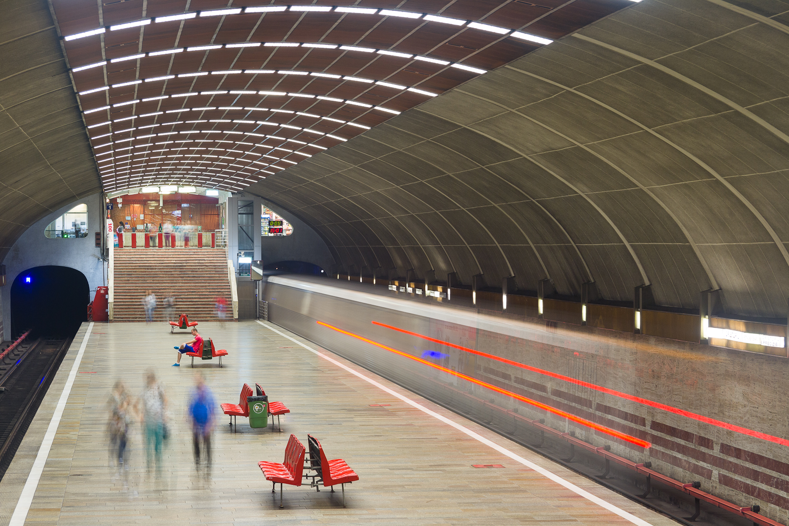
The Bucharest Metro ( ro, Metroul din București) is an underground rapid transit system that serves Bucharest, the capital of Romania. It first opened for service on 16 November 1979. The network is run by Metrorex. One of two parts of the larger Bucharest public transport network, Metrorex has an average of approximately 720,000 passenger trips per weekday (as of 2018), compared to the 1,180,000 daily riders on Bucharest's STB transit system. In total, the Metrorex system is long and has 64 stations. History The first proposals for a metro system in Bucharest were made in the early part of the 20th century, by the Romanian engineers Dimitrie Leonida and Elie Radu. The earliest plans for a Bucharest Metro were drafted in the late 1930s, alongside the general plans for urban modernization of the city. The outbreak of World War II, followed by periods of political tensions culminating with the installation of communism, put an end to the plans. By 1970, the public transport ... [...More Info...] [...Related Items...] OR: [Wikipedia] [Google] [Baidu] |
Transport In Bucharest
Bucharest has the largest transport network in Romania, and one of the largest in Europe. The Bucharest transport network is made up of a metro network and a surface transport network. Although there are multiple connection points, the two systems operate independently of each other, are run by different organisations (the metro is run by Metrorex and the surface transport network by Societatea de Transport București. The two companies used separate ticketing systems until 2021, when a new smartcard was introduced alongside the old tickets, which allows travel on both the STB and the Underground. Bucharest Metro Bucharest has a fairly extensive metro system consisting of five lines ( M1, M2, M3, M4, and M5) run by Metrorex. In total, the network is long and has 63 stations, with average distance between stops. It is one of the fastest ways to get around the city. Surface transport Surface transport in Bucharest is run by Societatea de Transport București (STB) and co ... [...More Info...] [...Related Items...] OR: [Wikipedia] [Google] [Baidu] |
List Of Bucharest Metro Stations
This is a list of the stations on the Bucharest Metro rapid transit system in Bucharest, Romania. There are 63 stations in the Bucharest Metro. Current Lines * Line 1: Dristor 2 — Pantelimon * Line 2: Pipera — Berceni * Line 3: Preciziei — Anghel Saligny * Line 4: Străulești — Gara de Nord 2 * Line 5: Râul Doamnei/ Valea Ialomiței — Eroilor 2 Stations For each of the 63 stations, the list reports the lines serving it, the opening year and the statistics of passenger usage; the English translation of the name (in quotes) and other names previously used (in italics) are listed, where available, in the second last column. Interchange (i) and terminal stations (t) are in bold. Extensions M2 (blue line) Opened in 1986, Line M2 is the busiest line crossing the city in the north–south direction, from Pipera to Berceni. An extension toward the Bucharest South Ring Road is under construction. * '' Tudor Arghezi'' M4 (green line) Line M4, opened in 20 ... [...More Info...] [...Related Items...] OR: [Wikipedia] [Google] [Baidu] |
Track Gauge In Hong Kong
Current use Standard gauge In Hong Kong, the ex-KCR East Rail line, the Tuen Ma line (combination of the 2 former ex-KCR West Rail and Ma On Shan lines), the Light Rail services, the West Island line, the Kwun Tong line extension and the South Island line use . Almost-standard gauge The Mass Transit Railway (MTR) lines (apart from the West Island line, Kwun Tong line extension and South Island line) that were not part of the Kowloon–Canton Railway (KCR) use the track gauge of , narrower than the standard gauge. This gauge is also used on the Bucharest Metro in Romania. Narrow gauge Hong Kong Tramways, which has been operating tram service on northern Hong Kong Island since 1904, uses a narrow gauge of . Rail gauge table Former narrow gauge The Kowloon–Canton Railway (now East Rail) was originally partially laid to and gauge during its construction, and the latter was proposed to be its gauge since the tunnel could only accommodate gauge if the line was to ... [...More Info...] [...Related Items...] OR: [Wikipedia] [Google] [Baidu] |
Bucharest
Bucharest ( , ; ro, București ) is the capital and largest city of Romania, as well as its cultural, industrial, and financial centre. It is located in the southeast of the country, on the banks of the Dâmbovița River, less than north of the Danube River and the Bulgarian border. Bucharest was first mentioned in documents in 1459. The city became the capital of Romania in 1862 and is the centre of Romanian media, culture, and art. Its architecture is a mix of historical (mostly Eclectic, but also Neoclassical and Art Nouveau), interbellum ( Bauhaus, Art Deco and Romanian Revival architecture), socialist era, and modern. In the period between the two World Wars, the city's elegant architecture and the sophistication of its elite earned Bucharest the nickname of 'Paris of the East' ( ro, Parisul Estului) or 'Little Paris' ( ro, Micul Paris). Although buildings and districts in the historic city centre were heavily damaged or destroyed by war, earthquakes, and even Nic ... [...More Info...] [...Related Items...] OR: [Wikipedia] [Google] [Baidu] |
Romania
Romania ( ; ro, România ) is a country located at the crossroads of Central Europe, Central, Eastern Europe, Eastern, and Southeast Europe, Southeastern Europe. It borders Bulgaria to the south, Ukraine to the north, Hungary to the west, Serbia to the southwest, Moldova to the east, and the Black Sea to the southeast. It has a predominantly Temperate climate, temperate-continental climate, and an area of , with a population of around 19 million. Romania is the List of European countries by area, twelfth-largest country in Europe and the List of European Union member states by population, sixth-most populous member state of the European Union. Its capital and largest city is Bucharest, followed by Iași, Cluj-Napoca, Timișoara, Constanța, Craiova, Brașov, and Galați. The Danube, Europe's second-longest river, rises in Germany's Black Forest and flows in a southeasterly direction for , before emptying into Romania's Danube Delta. The Carpathian Mountains, which cross Roma ... [...More Info...] [...Related Items...] OR: [Wikipedia] [Google] [Baidu] |
Armata Poporului Metro Station
''Lujerului'' metro station, previously known as ''Armata Poporului'' is a metro station in the Militari neighborhood of Bucharest. It is located at the intersection of Lujerului and Iuliu Maniu Avenues, close to the Lujerului road-tunnel, near the Cotroceni Freight Railway Terminal, the Lujerului Silo, Mills and Bread Factory, and next to the Cora Lujerului hypermarket. The metro station also services the Plaza Romania mall. It was opened on 19 August 1983 as part of the extension from Eroilor to Industriilor and currently serves M3. The station is also of the central platform design, slightly narrower than Politehnica, also built in marble and featuring a color scheme based on white, crimson and shades of gray. The previous name of the station comes from the former name of the easternmost portion of the Iuliu Maniu Avenue, that was formerly known as ''Armata Poporului'' (People's Army). The name of the avenue was changed in 1997 to honor Iuliu Maniu, an inter-war Romanian st ... [...More Info...] [...Related Items...] OR: [Wikipedia] [Google] [Baidu] |
Regia Autonomă De Transport București
The Regia ("Royal house") was a two-part structure in Ancient Rome lying along the Via Sacra at the edge of the Roman Forum that originally served as the residence or one of the main headquarters of kings of Rome and later as the office of the '' pontifex maximus'', the highest religious official of Rome. It occupied a triangular patch of terrain between the Temple of Vesta, the Temple of Divus Julius and Temple of Antoninus and Faustina. Only the foundations of Republican/Imperial Regia remain. Like the Curia it was destroyed and rebuilt several times, as far back as the Roman monarchy. Studies have found multiple layers of similar buildings with more regular features, prompting the theory that this "Republican Regia" was to have a different use. History According to ancient tradition it was built by the second king of Rome, Numa Pompilius, as a royal palace. Indeed, the Latin term ''regia'' can be translated as ''royal residence''. It is said that he also built the Temp ... [...More Info...] [...Related Items...] OR: [Wikipedia] [Google] [Baidu] |
Tineretului Metro Station
Tineretului (''Youth's'' station in English) is a metro station in Bucharest, Romania, on the Bucharest Metro Line M2. The station was inaugurated on 6 April 1986 as part of the previously built section of the line, from Piața Unirii to Depoul IMGB. The station is named for the Tineretului Park ''Tineretului'' Park (, "Youth's Park") is a large public park in southern Bucharest ( Sector 4). History The park, which was created in 1965 and finished in 1974, was planned by the architect Valentin Donose. It was designed as the main recreati ... (Youth's Park) nearby. References Bucharest Metro stations Railway stations opened in 1986 1986 establishments in Romania {{Romania-railstation-stub ... [...More Info...] [...Related Items...] OR: [Wikipedia] [Google] [Baidu] |
Rapid Transit
Rapid transit or mass rapid transit (MRT), also known as heavy rail or metro, is a type of high-capacity public transport generally found in urban areas. A rapid transit system that primarily or traditionally runs below the surface may be called a subway, tube, or underground. Unlike buses or trams, rapid transit systems are railways (usually electric railway, electric) that operate on an exclusive right-of-way (transportation), right-of-way, which cannot be accessed by pedestrians or other vehicles, and which is often grade-separated in tunnels or on elevated railways. Modern services on rapid transit systems are provided on designated lines between rapid transit station, stations typically using electric multiple units on rail tracks, although some systems use guided rubber tires, magnetic levitation (''maglev''), or monorail. The stations typically have high platforms, without steps inside the trains, requiring custom-made trains in order to minimize gaps between train a ... [...More Info...] [...Related Items...] OR: [Wikipedia] [Google] [Baidu] |
Kowloon–Canton Railway
The Kowloon–Canton Railway (KCR; ) was a railway network in Hong Kong.Legislative Council information paper CB(1)357/07-08(0 THB(T) CR 8/986/00, CB(1)1749/07-08(0/ref> It was owned and operated by the Kowloon-Canton Railway Corporation (KCRC) until 2007. Rapid transit services, a light rail system, feeder bus routes within Hong Kong, and intercity passenger and freight train services to China on the KCR network, have been operated by the MTR Corporation since 2007. While still owned by its previous operator, the KCR network (which is wholly owned by the Hong Kong Government through the KCRC) has been operated by the MTR Corporation Limited under a 50-year, extendible, service concession since 2 December 2007. The two companies have merged their local metro lines into one unified fare system. Immediately after the merger, steps were taken to integrate the network into the same fare system as the MTR, and gates between the two networks were removed in several stages in 200 ... [...More Info...] [...Related Items...] OR: [Wikipedia] [Google] [Baidu] |
Loading Gauge
A loading gauge is a diagram or physical structure that defines the maximum height and width dimensions in railway vehicles and their loads. Their purpose is to ensure that rail vehicles can pass safely through tunnels and under bridges, and keep clear of platforms, trackside buildings and structures. Classification systems vary between different countries, and gauges may vary across a network, even if the track gauge is uniform. The term loading gauge can also be applied to the maximum size of road vehicles in relation to tunnels, overpasses and bridges, and doors into automobile repair shops, bus garages, filling stations, residential garages, multi-storey car parks and warehouses. A related but separate gauge is the structure gauge, which sets limits to the extent that bridges, tunnels and other infrastructure can encroach on rail vehicles. The difference between these two gauges is called the clearance. The specified amount of clearance makes allowance for wobbling of ... [...More Info...] [...Related Items...] OR: [Wikipedia] [Google] [Baidu] |
Track Gauge
In rail transport, track gauge (in American English, alternatively track gage) is the distance between the two rails of a railway track. All vehicles on a rail network must have wheelsets that are compatible with the track gauge. Since many different track gauges exist worldwide, gauge differences often present a barrier to wider operation on railway networks. The term derives from the metal bar, or gauge, that is used to ensure the distance between the rails is correct. Railways also deploy two other gauges to ensure compliance with a required standard. A '' loading gauge'' is a two-dimensional profile that encompasses a cross-section of the track, a rail vehicle and a maximum-sized load: all rail vehicles and their loads must be contained in the corresponding envelope. A ''structure gauge'' specifies the outline into which structures (bridges, platforms, lineside equipment etc.) must not encroach. Uses of the term The most common use of the term "track gauge" refers to the ... [...More Info...] [...Related Items...] OR: [Wikipedia] [Google] [Baidu] |

.jpg)


