|
Meare Pool
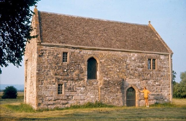
Meare Pool (also known as Ferlingmere, Ferran Mere or Meare fish pool) was a lake in the Somerset Levels in South West England. Lake villages existed there in prehistoric times. During medieval times it was an important fishery, but following extensive drainage works it had disappeared from maps in the eighteenth century. Location Meare Pool was formed by water ponding-up behind the raised peat bogs between the Wedmore and the Polden Hills, and core samples have shown that it is filled with at least of detritus mud, especially in the Subatlantic climatic period (1st millennium BC). Meare Pool was located on low-lying levels just north of Meare. Its precise boundaries varied according to season, and, over the longer term, as efforts were made to drain the area. Early 16th century surveys variously describe it as being up to a mile and a half wide and having a circumference of between 2.5 and 5 miles. The south end was bordered by the high ground that the village of Meare is built ... [...More Info...] [...Related Items...] OR: [Wikipedia] [Google] [Baidu] |
Somerset Levels
The Somerset Levels are a coastal plain and wetland area of Somerset, England, running south from the Mendip Hills, Mendips to the Blackdown Hills. The Somerset Levels have an area of about and are bisected by the Polden Hills; the areas to the south are drained by the River Parrett, and the areas to the north by the rivers River Axe (Bristol Channel), Axe and River Brue, Brue. The Mendip Hills separate the Somerset Levels from the North Somerset Levels. The Somerset Levels consist of marine clay "levels" along the coast and inland peat-based "moors"; agriculturally, about 70 per cent is used as grassland and the rest is arable. Willow and Dipsacus fullonum, teazel are grown commercially and peat is extracted. A Palaeolithic flint tool found in West Sedgemoor is the earliest indication of human presence in the area. The Neolithic people exploited the reed swamps for their natural resources and started to construct wooden trackways, including the world's oldest known tim ... [...More Info...] [...Related Items...] OR: [Wikipedia] [Google] [Baidu] |
Listed Building
In the United Kingdom, a listed building or listed structure is one that has been placed on one of the four statutory lists maintained by Historic England in England, Historic Environment Scotland in Scotland, in Wales, and the Northern Ireland Environment Agency in Northern Ireland. The term has also been used in the Republic of Ireland, where buildings are protected under the Planning and Development Act 2000. The statutory term in Ireland is " protected structure". A listed building may not be demolished, extended, or altered without special permission from the local planning authority, which typically consults the relevant central government agency, particularly for significant alterations to the more notable listed buildings. In England and Wales, a national amenity society must be notified of any work to a listed building which involves any element of demolition. Exemption from secular listed building control is provided for some buildings in current use for worship, ... [...More Info...] [...Related Items...] OR: [Wikipedia] [Google] [Baidu] |
Ordnance Survey
, nativename_a = , nativename_r = , logo = Ordnance Survey 2015 Logo.svg , logo_width = 240px , logo_caption = , seal = , seal_width = , seal_caption = , picture = , picture_width = , picture_caption = , formed = , preceding1 = , dissolved = , superseding = , jurisdiction = Great BritainThe Ordnance Survey deals only with maps of Great Britain, and, to an extent, the Isle of Man, but not Northern Ireland, which has its own, separate government agency, the Ordnance Survey of Northern Ireland. , headquarters = Southampton, England, UK , region_code = GB , coordinates = , employees = 1,244 , budget = , minister1_name = , minister1_pfo = , chief1_name = Steve Blair , chief1_position = CEO , agency_type = , parent_agency = , child1_agency = , keydocument1 = , website = , footnotes = , map = , map_width = , map_caption = Ordnance Survey (OS) is the national mapping agency for Great Britain. The agency's name indicates its original military purpose (se ... [...More Info...] [...Related Items...] OR: [Wikipedia] [Google] [Baidu] |
Glastonbury Abbey
Glastonbury Abbey was a monastery in Glastonbury, Somerset, England. Its ruins, a grade I listed building and scheduled ancient monument, are open as a visitor attraction. The abbey was founded in the 8th century and enlarged in the 10th. It was destroyed by a major fire in 1184, but subsequently rebuilt and by the 14th century was one of the richest and most powerful monasteries in England. The abbey controlled large tracts of the surrounding land and was instrumental in major drainage projects on the Somerset Levels. The abbey was suppressed during the Dissolution of the Monasteries under King Henry VIII of England. The last abbot, Richard Whiting (Whyting), was hanged, drawn and quartered as a traitor on Glastonbury Tor in 1539. From at least the 12th century the Glastonbury area has been associated with the legend of King Arthur, a connection promoted by medieval monks who asserted that Glastonbury was Avalon. Christian legends have claimed that the abbey was founded by J ... [...More Info...] [...Related Items...] OR: [Wikipedia] [Google] [Baidu] |
River Hartlake
A river is a natural flowing watercourse, usually freshwater, flowing towards an ocean, sea, lake or another river. In some cases, a river flows into the ground and becomes dry at the end of its course without reaching another body of water. Small rivers can be referred to using names such as Stream#Creek, creek, Stream#Brook, brook, rivulet, and rill. There are no official definitions for the generic term river as applied to Geographical feature, geographic features, although in some countries or communities a stream is defined by its size. Many names for small rivers are specific to geographic location; examples are "run" in some parts of the United States, "Burn (landform), burn" in Scotland and northeast England, and "beck" in northern England. Sometimes a river is defined as being larger than a creek, but not always: the language is vague. Rivers are part of the water cycle. Water generally collects in a river from Precipitation (meteorology), precipitation through a ... [...More Info...] [...Related Items...] OR: [Wikipedia] [Google] [Baidu] |
River Axe (Bristol Channel)
The River Axe is a river in South West England. The river is formed by water entering swallets in the limestone and rises from the ground at Wookey Hole Caves in the Mendip Hills in Somerset, and runs through a V-shaped valley. The geology of the area is limestone and the water reaches Wookey Hole in a series of underground channels that have eroded through the soluble limestone. The river mouth is in Weston Bay on the Bristol Channel. The river was navigable from the middle ages until 1915, during early centuries of which seeing some European trade. Geography The River Axe is formed by the water entering the cave systems and flows through the third and first chambers, from which it flows to the resurgence, through two sumps and long, where it leaves the cave and enters the open air. It is the second largest resurgence on Mendip, with an estimated catchment area of , and an average discharge of per second. Some of the water is allogenic in origin i.e. drained off ... [...More Info...] [...Related Items...] OR: [Wikipedia] [Google] [Baidu] |
River Sheppey
The River Sheppey has its source in a group of springs west of the village of Doulting, near Shepton Mallet in Somerset, England. It flows through the wetlands to the north of the Polden Hills and ultimately joins the River Brue. Route From Doulting, the Sheppey flows south west to Charlton, where parts of its course have been culverted. The river has been diverted underground for much, though not all, of its passage through Shepton Mallet. It reappears at Darshill and then flows south west through Croscombe to Dinder where it flows through the grounds of Dinder House which was built in 1801 and under a bridge which pre-dates the house. It then continues west past Dulcote, Woodford and Coxley. At Coxley it is joined by the Keward Brook which carries the water from the springs in Wells which fill the moat of the Bishop's Palace. From Coxley, the river flows north through Hay Moor and North Moor, west through Ash Moor, then sharply south through Frogmore and west through God ... [...More Info...] [...Related Items...] OR: [Wikipedia] [Google] [Baidu] |
River Brue
The River Brue originates in the parish of Brewham in Somerset, England, and reaches the sea some west at Burnham-on-Sea. It originally took a different route from Glastonbury to the sea, but this was changed by Glastonbury Abbey in the twelfth century. The river provides an important drainage route for water from a low-lying area which is prone to flooding which man has tried to manage through rhynes, canals, artificial rivers and sluices for centuries. The Brue Valley Living Landscape is an ecological conservation project based on the Somerset Levels and Moors and managed by the Somerset Wildlife Trust. The valley includes several Sites of Special Scientific Interest including Westhay Moor, Shapwick Heath and Shapwick Moor. Much of the area has been at the centre of peat extraction on the Somerset Levels. The Brue Valley Living Landscape project commenced in January 2009 to restore and reconnect habitat that will support wildlife. The aim is to be able to sustain itself in ... [...More Info...] [...Related Items...] OR: [Wikipedia] [Google] [Baidu] |
Lent
Lent ( la, Quadragesima, 'Fortieth') is a solemn religious observance in the liturgical calendar commemorating the 40 days Jesus spent fasting in the desert and enduring temptation by Satan, according to the Gospels of Matthew, Mark and Luke, before beginning his public ministry. Lent is observed in the Anglican, Eastern Orthodox, Lutheran, Methodist, Moravian, Oriental Orthodox, Persian, United Protestant and Roman Catholic traditions. Some Anabaptist, Baptist, Reformed (including certain Continental Reformed, Presbyterian and Congregationalist churches), and nondenominational Christian churches also observe Lent, although many churches in these traditions do not. Which days are enumerated as being part of Lent differs between denominations (see below), although in all of them Lent is described as lasting for a total duration of 40 days. In Lent-observing Western Churches, Lent begins on Ash Wednesday and ends approximately six weeks later; depending on the Christian ... [...More Info...] [...Related Items...] OR: [Wikipedia] [Google] [Baidu] |
Fasting
Fasting is the abstention from eating and sometimes drinking. From a purely physiological context, "fasting" may refer to the metabolic status of a person who has not eaten overnight (see " Breakfast"), or to the metabolic state achieved after complete digestion and absorption of a meal. Metabolic changes in the fasting state begin after absorption of a meal (typically 3–5 hours after eating). A diagnostic fast refers to prolonged fasting from 1 to 100 hours (depending on age) conducted under observation to facilitate the investigation of a health complication, usually hypoglycemia. Many people may also fast as part of a medical procedure or a check-up, such as preceding a colonoscopy or surgery, or before certain medical tests. Intermittent fasting is a technique sometimes used for weight loss that incorporates regular fasting into a person's dietary schedule. Fasting may also be part of a religious ritual, often associated with specifically scheduled fast days, as determ ... [...More Info...] [...Related Items...] OR: [Wikipedia] [Google] [Baidu] |


