|
Matthew Flinders
Captain Matthew Flinders (16 March 1774 – 19 July 1814) was a British navigator and cartographer who led the first inshore circumnavigation of mainland Australia, then called New Holland. He is also credited as being the first person to utilise the name ''Australia'' to describe the entirety of that continent including Van Diemen's Land (now Tasmania), a title he regarded as being "more agreeable to the ear" than previous names such as ''Terra Australis''. Flinders was involved in several voyages of discovery between 1791 and 1803, the most famous of which are the circumnavigation of Australia and an earlier expedition when he and George Bass confirmed that Van Diemen's Land was an island. While returning to Britain in 1803, Flinders was arrested by the French governor at Isle de France (Mauritius). Although Britain and France were at war, Flinders thought the scientific nature of his work would ensure safe passage, but he remained under arrest for more than six years. In ... [...More Info...] [...Related Items...] OR: [Wikipedia] [Google] [Baidu] |
George Bass
George Bass (; 30 January 1771 – after 5 February 1803) was a British naval surgeon and explorer of Australia. Early years Bass was born on 30 January 1771 at Aswarby, a hamlet near Sleaford, Lincolnshire, the son of a tenant farmer, George Bass, and a local beauty named Sarah (née Newman). His father died in 1777 when Bass was 6. He had attended Boston Grammar School and later trained in medicine at the hospital in Boston, Lincolnshire. At the age of 18, he was accepted in London as a member of the Company of Surgeons, and in 1794 he joined the Royal Navy as a surgeon. He arrived in Sydney in New South Wales on HMS ''Reliance'' on 7 September 1795. Also on the voyage were Matthew Flinders, John Hunter, Bennelong, and his surgeon's assistant William Martin. The voyages of the Tom Thumb and Tom Thumb II Bass had brought with him on the ''Reliance'' a small boat with an keel and beam, which he called the Tom Thumb on account of its size. In October 1795 Bass and Flin ... [...More Info...] [...Related Items...] OR: [Wikipedia] [Google] [Baidu] |
Antoine Toussaint De Chazal
upPortrait of Captain Matthew Flinders (1806–1807) Antoine Toussaint de Chazal (1770–1854) was a French settler established as a planter on the (now Mauritius). De Chazal was born on 15 December 1770, in Port Louis, . He was deputy of the district of Pamplemousses, in the colonial Assembly of the . He was an amateur painter and is known for his portrait of the British cartographer and Royal Navy captain Matthew Flinders, painted in 1806–1807. The fourth edition of the ''Benezit Dictionary of Artists'' confuses him with the painter Antoine Chazal (1793–1854). He died in Moka, , on 25 December 1822 and is an ancestor of Malcolm de Chazal. Work * Portrait of Captain Matthew Flinders, oil on canvas, 50x64.5 cm. Gift of David Roche in memory of his father, J.D.K. Roche, and the South Australian Government 2000, to the Art Gallery of South Australia, Adelaide. References * "Flinders Captain Flinders at Flinders: an exhibition of his oil portrait by Chazal", Ade ... [...More Info...] [...Related Items...] OR: [Wikipedia] [Google] [Baidu] |
High Speed 2
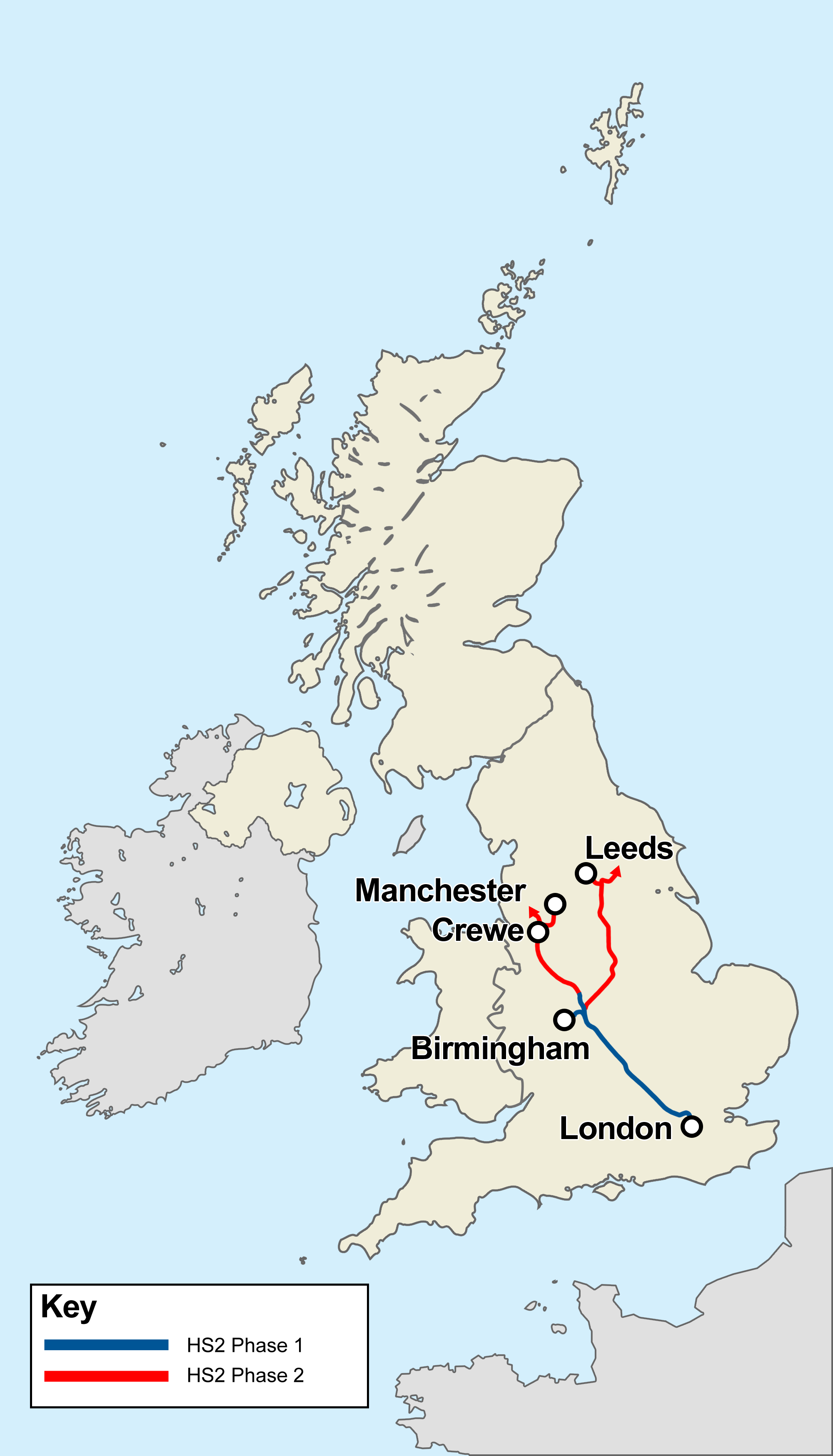
High Speed 2 (HS2) is a planned high-speed railway line in England, the first phase of which is under construction in stages and due for completion between 2029 and 2033, depending on approval for later stages. The new line will run from its most southerly terminus, London, to its most northerly point, Manchester, with branches to Birmingham and the East Midlands. HS2 will be Britain's second purpose-built High-speed rail in the United Kingdom, high-speed line, the first being High Speed 1, which connects London to the Channel Tunnel. At its southern end, the line will terminate at London's London Euston railway station, Euston station while other termini will be Birmingham Curzon Street railway station, Birmingham Curzon Street station and Manchester Piccadilly station. In addition to these stations, the dedicated track will serve Old Oak Common railway station, Old Oak Common in west London, Birmingham Interchange, East Midlands Parkway railway station, East Midlands Parkway ... [...More Info...] [...Related Items...] OR: [Wikipedia] [Google] [Baidu] |
Adventure Bay, Tasmania
Adventure Bay is the name of a locality, a township and a geographical feature on the eastern side of Bruny Island, Tasmania. At the , Adventure Bay had a population of 218. Early history The first European to sight the bay was explorer Abel Tasman, who sought to anchor his vessel ''Heemskerck'' there in 1642. Instead, ''Heemskerck'' was driven back offshore by a storm, in token of which Tasman named the place Storm Bay. Captain Tobias Furneaux renamed it in March 1773, in honour of his ship , which he had anchored in the bay for five days after becoming separated from Captain James Cook's during Cook's second voyage to the Pacific search of Terra Australis Incognita. Furneaux's log made clear the bay was an excellent anchorage for resupplying vessels:To the SW of the first watering place there is a large lagoon which I believe has plenty of fish in it for one of our Gentlemen caught upwards of 2 dozen trout, and shot a possum which was the only animal we saw. There are a g ... [...More Info...] [...Related Items...] OR: [Wikipedia] [Google] [Baidu] |
Cape Of Good Hope
The Cape of Good Hope ( af, Kaap die Goeie Hoop ) ;''Kaap'' in isolation: pt, Cabo da Boa Esperança is a rocky headland on the Atlantic coast of the Cape Peninsula in South Africa. A common misconception is that the Cape of Good Hope is the southern tip of Africa, based on the misbelief that the Cape was the dividing point between the Atlantic and Indian oceans, and have nothing to do with north or south. In fact, by looking at a map, the southernmost point of Africa is Cape Agulhas about to the east-southeast. The currents of the two oceans meet at the point where the warm-water Agulhas current meets the cold-water Benguela current and turns back on itself. That oceanic meeting point fluctuates between Cape Agulhas and Cape Point (about east of the Cape of Good Hope). When following the western side of the African coastline from the equator, however, the Cape of Good Hope marks the point where a ship begins to travel more eastward than southward. Thus, the first mode ... [...More Info...] [...Related Items...] OR: [Wikipedia] [Google] [Baidu] |
Mutiny On The Bounty
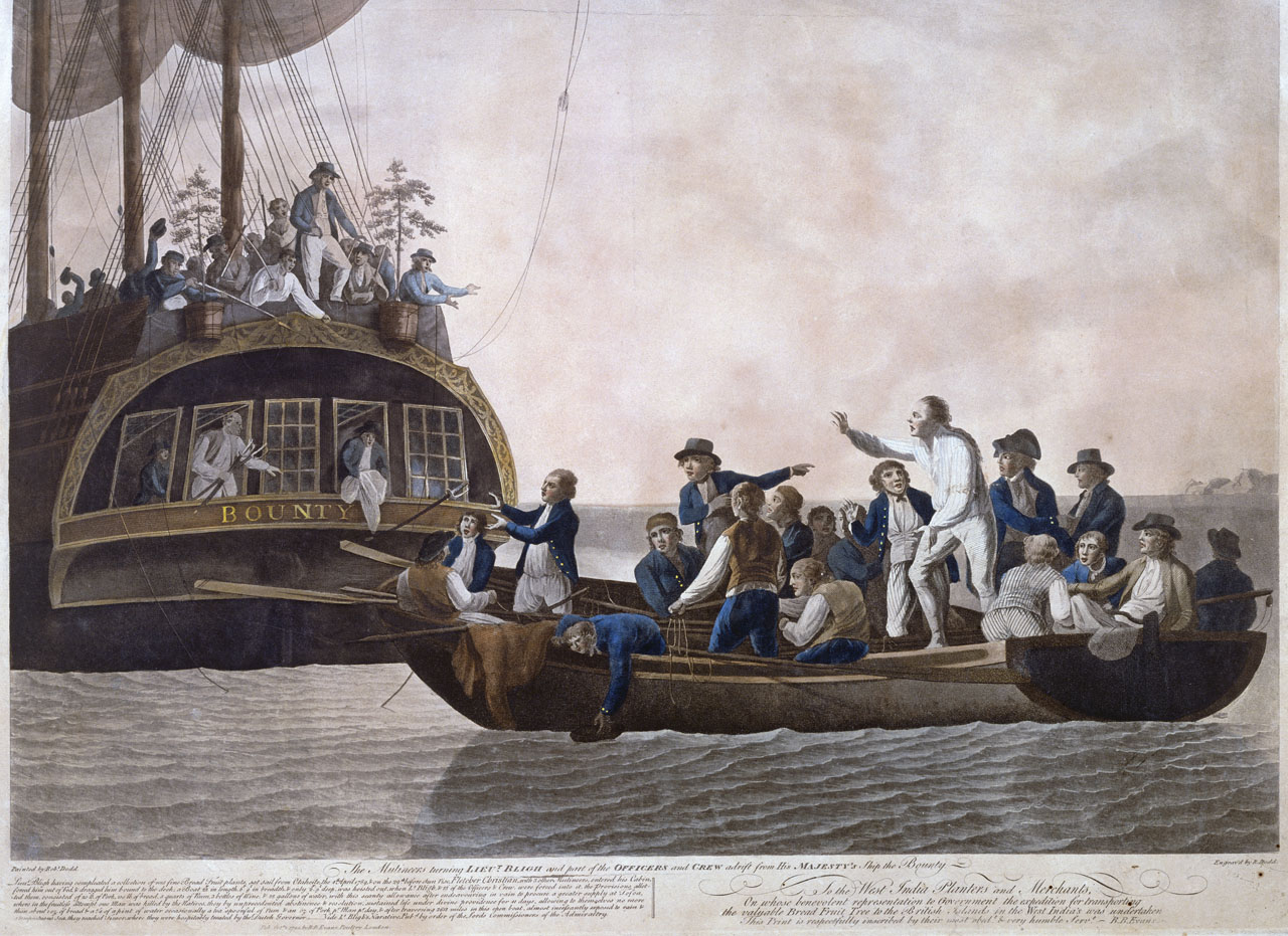
The mutiny on the Royal Navy vessel occurred in the South Pacific Ocean on 28 April 1789. Disaffected crewmen, led by acting-Lieutenant Fletcher Christian, seized control of the ship from their captain, Lieutenant William Bligh, and set him and eighteen loyalists adrift in the ship's open launch. The mutineers variously settled on Tahiti or on Pitcairn Island. Bligh navigated more than in the launch to reach safety, and began the process of bringing the mutineers to justice. ''Bounty'' had left England in 1787 on a mission to collect and transport breadfruit plants from Tahiti to the West Indies. A five-month layover in Tahiti, during which many of the men lived ashore and formed relationships with native Polynesians, led those men to be less amenable to military discipline. Relations between Bligh and his crew deteriorated after he allegedly began handing out increasingly harsh punishments, criticism, and abuse, Christian being a particular target. After three weeks ba ... [...More Info...] [...Related Items...] OR: [Wikipedia] [Google] [Baidu] |
Jamaica
Jamaica (; ) is an island country situated in the Caribbean Sea. Spanning in area, it is the third-largest island of the Greater Antilles and the Caribbean (after Cuba and Hispaniola). Jamaica lies about south of Cuba, and west of Hispaniola (the island containing the countries of Haiti and the Dominican Republic); the British Overseas Territory of the Cayman Islands lies some to the north-west. Originally inhabited by the indigenous Taíno peoples, the island came under Spanish rule following the arrival of Christopher Columbus in 1494. Many of the indigenous people either were killed or died of diseases, after which the Spanish brought large numbers of African slaves to Jamaica as labourers. The island remained a possession of Spain until 1655, when England (later Great Britain) conquered it, renaming it ''Jamaica''. Under British colonial rule Jamaica became a leading sugar exporter, with a plantation economy dependent on the African slaves and later their des ... [...More Info...] [...Related Items...] OR: [Wikipedia] [Google] [Baidu] |


